by TIM MCCALL

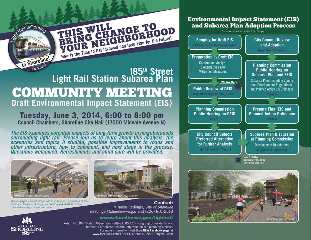
Those affected by, and interested in, the planned construction of light rail on the Lynnwood Link Corridor are encouraged to attend a series of community meetings related to planning for the two station areas in Shoreline, adjacent I-5 at 145th St and 185th St.
The topic of these meetings will be the Draft Environmental Impact Statement (DEIS) for 185th Street, and a Design Workshop for the 145th Station near Jackson Park. The meetings will be held at Shoreline City Hall on Midvale Avenue and N 175th Street. Shoreline City Hall is accessible via King County Metro routes 301, 348 (with a short walk from N 185th) and RapidRide E, 301, and 348.
The 185th Street Light Rail Station Subarea Plan community meeting (flyer) will be held on June 3rd. In a recent newsletter from the City of Shoreline, proposals for upzoning parcels in the immediate vicinity of the light rail station was developed. The upzoning of N 185th Street from Aurora to I-5 was envisioned. In addition to the 185th Street DEIS community meeting on June 3rd, the City has planned a walking tour around the 185th Street Station Subarea on June 13th (14:00-16:00).
The 145th Street Light Rail Station Design Workshop (flyer) will take place from 18:00 – 20:00 on June 12th. The design workshop appears to be looking for ideas to improve pedestrian and bicycle access to and from the light rail facility within the mobility study area. Similar to the walking tours around the 185th Street Station Subarea, a 145th Street Station Subarea walking tour is planned for June 27th (14:00 – 16:00).
Tim McCall is a resident of Shoreline.
I’m still a bit intrigued why ST insists on making a light rail system do the job of an intercity train. There are much more suitable rolling stock (wider, higher speed, more expandable) and track configurations (wider loading gauge) for this purpose. Any info on journey times to Lynnwood?
Timeh
28 minutes Lynnwood – Westlake. 16 minutes Lynnwood – U-District. 65 minutes Lynnwood – SeaTac (plus transfer, minus improvements when buses are kicked out of DSTT).
28 minutes Lynwood-Westlake.
16 minutes Lynwood-UW.
The only way you can come close to that in a car is by driving at 4:00 Sunday morning. Assuming no lanes are blocked off for construction.
This is going to be great.
Though some off peak buses may be faster, the more reliable route will get more use. I can easily see myself having folks meet me near a station on the north end to do something. Alderwood mall will be easily walkable (or bikable) from the park and ride at the northern terminus.
It would be nice to run the trains faster outside of downtown, but perhaps we can worry about that more later after the system is a bit more built out. Its going to be fully grade separated or have devoted ROW all the way to Lynnwood transfer center, so I imagine if we wanted to upgrade to faster vehicles at some point we probably could.
A cost benefit analysis would be needed to see if faster trains would be more important than expanding the system though.
At the first Lynnwood design meeting, several residents were excited about a frequent train to the airport even though it was already clear it would take at least an hour travel time. Snohomans seem to think differently about the airport than Seattlites. If you told a Seattleite that a train to the airport will take an hour he’d say, “I’m taking a taxi” and would go on highway 99. But from Snohomish County a taxi would probably take an hour anyway because it’s going through twice as much congestion (south Seattle, central Seattle, north Seattle, Shoreline, Snohomish).
The 512 northbound is 27 minutes Westlake – Lynnwood at 7am; the 511 is 40 minutes at 5pm. Of course they’re less reliable.
@Mike Orr As a former Snohomish county resident I can verify that many of the folks I know from up there are really really tired of the traffic jams getting south to Seattle and past there to the airport. This will be a very popular route for sure.
If it’s going to be 28 minutes Lynnwood – Westlake and 16 minutes Lynnwood – U-District, that would seem to indicate 12 minutes from U District – Westlake, but I’ve heard 8 minutes for the same. Is one of those numbers off?
Northbound from Westlake, 3 minutes to Capitol Hill, 8 minutes to UW, 12 minutes to U-District, 15 minutes to Northgate, 28 minutes to Lynnwood. Soutbound from Westlake, existing time is 37 minutes to SeaTac. Eastbound from Westlake I don’t remember the estimates but I’d guess 30-40 minutes to Bellevue and 40-60 minutes to Redmond.
In comparison, existing non-DSTT stations are 2-4 minutes apart. (The big gap between Rainier Beach and TIB is 9 minutes.)
Some of these times seem implausably long. How can it take 3 minutes to get from Westlake to Capitol Hill, or 4 minutes from UW to U-District? I assume the times are padded, or the curves cause significant slowdowns.
@Mike Orr
I wonder if some of these times are padded (as you suggest), but for tunnel congestion. Perhaps the times will improve a bit more when the buses come out of the tunnel?
28 minutes Lynwood-Westlake.
16 minutes Lynwood-UW.
(……)
This is going to be great.
I already sent in a complaint to SoundTransit asking if they would be willing to consider increasing the speeds. The line is elevated on a structure that in many parts of the world would see faster speeds than 55 mph. My hope is that before they start construction they can do what it requires to get the speed up in the range of, say, the 70 mph cars KinkiSharyo built for certain other cities.
Light rail was chosen because it can run on streets a la MLK; this was seen as a cost-cutting measure. Originally International Blvd was going to be surface too, but Tukwila quashed that because Intl Blvd had just been rebuilt and the city didn’t want it torn up again.
I’m glad we didn’t end up with two surface sections. It would have been nice to have a highway 99 routing to the airport though.
I think it was a good choice. The ability to run in city streets where desirable means that lower speed and more economical branch lines can be made if necessary or desirable. If necessary or desirable it is possible to run low floor light rail cars on freight track with time based separation, but high level platforms prevent this.
For their “streetcar”, Atlanta chose the Siemens S70 – which is the same car design used here in Portland for the light rail lines. If their streetcar ever gets to the point where they need to go onto a private right of way and operate at higher speeds, these cars will be able to operate as either light rail or streetcar. Just the same as that, a light rail car could be used as a streetcar if necessary in places. For example, drop the SLUT into a tunnel and join it to one of the underground light rail lines. Sadly, the SLUT was built with very tight clearances so it could never accept a LINK car as a streetcar, but that does not mean future streetcar lines that are intended to serve as branches of LINK need to be built that way.
@CharlesB
There are two surface running sections. One in SODO and one on MLK.
@Glenn In Portland
With what you say about the SLUT, does this mean that Tacoma Link would need to have its station platforms rebuilt if it were joined to South Link? I believe it uses similar vehicles to those on the SLUT.
SODO is a different kind of surface: the track is isolated from the street and it has bells and gates, which let it run a bit faster and ignore traffic signals.
Tacoma Link is a streetcar in spite of its name and paint job. Putting Central Link on it would require changing the voltage, extending the platforms for larger 4-car trains, making sure the blocks are long enough for it, eliminating any lane-shares with cars, eliminating single-tracking, etc. I don’t think there are any plans for that. Central Link would terminate at Tacoma Dome, and Tacoma Link would go from there to downtown and throughout Tacoma. The first chosen line is to the Hilltop neighborhood. Potential future lines could be on 6th Avenue and Pacific Street. Tacoma would likely freak out at large elevated guideways or wide street reservations for Central Link in its neighborhoods, because it’s just not used to big-city things like Seattle is.
The system isn’t meant to resemble an intercity rail line. The more it does, the more we will have failed. For North Link, I don’t think this is the case. From the city limits at 145th, for example, I see six stations* between there and downtown (130th, Northgate, Roosevelt, U-District, Husky Stadium, Capitol Hill). The only significant gap is between Northgate and Roosevelt, about two miles. I don’t think that heavier rail would speed things up that much. From a design standpoint, this is a fairly good line for everyone. The folks in Lynnwood lose a little time compared to an express bus, but gain it back with frequency and the ability to reach a lot of really heavily used locations (UW being the biggest). It isn’t just the spots on the line, either. Someone trying to get to Lake City or Fremont from Lynnwood, for example, will save a lot of time by taking the train.
For the south end, however, it isn’t clear what the line is supposed to be doing. On the one hand, as already mentioned, you have a classic light rail line going down a city street. Nothing wrong with that. Rainier valley is the most densely populated area along that line (south of Beacon Hill), but it is no where near as populated as Capitol Hill or the UW. So matching the quality of the system to the density makes sense there (not as many people so less than ideal ride). Plus it is slow, but not horribly so. But then it tries to turn into an intercity system. It goes for about 7 miles without another stop. Here is where the frustration with the system arises. For folks getting to the airport (an intercity type location, given the distance) it is fairly slow. But for folks in Rainier Valley, you have to wonder why it suddenly goes 7 miles without a stop. If there aren’t any good stops for seven miles, maybe it would be better to just end it (at Rainier Beach) and put up a big transit center there. In many ways, the system was built so that it could demonstrate to the voters that we could build something, as opposed to building something that makes any sense.
* There should have been at least one more, of course: First Hill.
A station between Northgate and Roosevelt also would have been nice, but because it goes close to the freeway, that would have been tricky. Ideally it wouldn’t go close to the freeway, but that would add to the expense (assuming it served Northgate). If it served Lake City (instead of Northgate) then it could have added a couple stops between Roosevelt and Lake City, but at least one of those would be in a pretty low density area. You were likely to have a gap, unless you swung east a little after Roosevelt, then swung back west again to get to Northgate. As I said, that would have added a fair amount to the cost (and slowed things down a bit). Of course, after it leaves the city, you are likely to have some pretty big gaps in density (as big as any in Seattle) but you may have some really good areas for bus to rail transfer.
Guess that means we failed pretty hard!
The powers that be are talking about building Link out to Tacoma and Everett with two-mile spacing between stops! And if us city-dwellers want anything resembling the rail system we should have built in the 70s, we better play along and wait our turn. The gold-plated single seat ride to the middle of nowhere is far more politically valuable than actually moving people in the urban zone.
@Kyle S.
The two mile spacing would not be ideal for sure, but neither Everett nor Tacoma are the middle of nowhere. They are both the largest cities in their respective counties and in the top six by population for the state.
Now perhaps you do have to pass through some pretty low density areas to get to these cities, but they are worth having on the main transit spine.
I would not put them at higher priority over connecting the city to itself (Ballard to West Seattle and Ballard to UW for example) but I don’t think that is going on right now.
The money to connect the rest of the way to Everett comes from the Snohomish sub area and the money to connect to Tacoma comes from the South King and Pierce sub areas. Neither take any funds from the Seattle sub area.
It is a hybrid in-between system. That’s because people were not willing to pay for two levels of service (a city subway and a regional interurban). Streetcars are too slow. Half-hourly Sounder was not considered due to BNSF fees and freight congestion, and it doesn’t go near major destinations anyway (airport, UW, Seattle-Bellevue, Lynnwood). Sounder was sold as low-hanging fruit (low capital cost and quick to get running because of the existing track), not as a comprehensive regional service.
The initial segments have rather wide stop spacing. There’s some regret for that, which is why the extensions have tentative extra stations.
Lynnwood – Westlake and Westlake – Redmond are clearly competitive on travel time. The 520 shortcuts to UW are just that, shortcuts, which may or may not justify continuing bus service; that’s a separate debate.
The south end has an identity crisis. Westlake – Rainier Beach is mediocre rapid transit. Westlake – SeaTac is also mediocre but is one of the most popular trips, and will become even more popular when UW and Lynnwood come on-line. The “Rainier Valley overhead” is 10 minutes for east-west travel and maybe 5 minutes for surface. A Georgetown bypass would not be nonstop so assume 2-3 stations.
Federal Way should understand now that Westlake – Federal Way would be 55 minutes, and Piercians should understand that Westlake – Tacoma may be 70 or 75 minutes. (577: 40 minutes at noon, 179: 42 minutes at 5pm). (594: 55 minutes at noon, 65 minutes at 5pm.) If they want fast they should consider something other than Link. If they want frequent full-time but not fast, then Link would do it. But don’t forget that Link will also serve Tacoma – SeaTac and Tacoma – UW trips.
Nobody raised an 85th station during the design that I heard. It was assumed that 85th would remain low-density and freeway-encumbered, so no point in a station.
The airport is an important destination, and worth the gap. The Chicago El doesn’t stop at the edge of the city and refuse to go to O’Hare, and that’s partly why the El is so well used. The area in the TIB – Rainier Beach gap is all industrial and highways, so no reason for a station. The only reason would be to truncate the 150 at 133rd, and that would cost millions of dollars for a minor benefit. A Boeing Access station would not be worth it unless Sounder goes to half-hourly, because 90% of runs would find no Sounder there.
@Mike Orr
A station at 85th really only makes sense to me if you are closer to Aurora or Greenwood. Maybe on a future line…
@ Mike and Charles — The census block at about 85th and 15th NE is over 10,000 people per square mile. This is nothing special by Seattle standards, but more than the vast majority of tracts south of the city. The one exception down south is Kent, but Link manages to skip to the side of it. Anyway, a station at 85th and 15th might have been good not only because of the people who live around there, but also because of the obvious connections (to Lake City Way, the freeway and 15th NE). But it would have cost a little more, and would have slowed down the train a little bit. It is no big deal, in my opinion; since I don’t think it is a huge loss.
The fact that the airport is such a popular destination shows how poorly we have done. There are a fair number of people in Rainier Valley, but we managed to make it so difficult for them to take the train that they just as soon take the bus (thank God we didn’t kill all the bus service). Put it this way — how long do you think it will take for the Capitol Hill station to overpass the airport? Keep in mind, the ride to the airport is essentially an express ride once it leaves Rainier Beach (one stop in between). I’m sure if light rail went directly from Rainier Beach to Portland it would be popular (faster than Amtrak and a lot more frequent) but it would be a waste of money. Going to the airport first was silly, but it satisfied the demands of suburban voters. Once they built that, they got confidence in the system, which means they couldn’t sink light rail (the way they did the first time (http://www.historylink.org/index.cfm?DisplayPage=output.cfm&file_id=2677)).
Oh, and comparing Seattle and Chicago is really silly. Chicago is much, much bigger and has miles and miles of track built inside the city long before they ran a line out to the airport (the line to the airport wasn’t built until 1984). Plus there are plenty of stops along the way, serving areas that are quite dense. The Cumberland station serves a couple census tracts with over 35,000 people per square mile. That’s bigger than anything south of I-90. It also serves some pretty big office towers. In other words, no one said “Hey, let’s run a line all the way out to the airport, as an express route (with very few stops in between)”. They said “As long as we are going all the way out there (to serve areas like Cumberland) we might as well go to the airport”.
I disagree with a number of your conclusions.
For starters, while I don’t visit the Ranier Valley often, when I do, I always walk from the nearest Link station. I never ride the 7, even if my ultimate destination is on or east of Ranier. Why? Because the 7 is excruciatingly slow and unreliable. Even if the time savings of Link is largely canceled out by the extra walking, at least with Link and walking, you’re in control, rather at the mercy of a bunch of change fumblers.
As to the airport, one only needs to look at the 194 route we had prior to Link to see the difference. On paper, the route was nonstop down I-5, so it should have been faster than Link. In practice, the bus was chronically late, cruised down I-5 at 40 mph while all the cars around it were doing 60-70, lacked the signal priority that Link has through SODO (and had a couple extra turns and stoplights too), and was significantly slower than Link at loading and unloading passengers in the downtown tunnel stops. When all was said and done, the actual time savings of the 194 over Link today was less than 5 minutes. On top of that, the 194 lacked sufficient room for luggage, and was overcrowded during peak travel times, sometimes to the point where people got outright passed up. It also ran less frequently than Link does and stopped running altogether as early as 7 PM. Once the 194 stopped running, the only way between the airport and downtown was the 174, a milk run through Tukwila and Georgetown, similar to route 124 today.
Finally, in another 2 years, being able to hop on the train north of downtown and ride all the way to the airport without a transfer will save an additional 20 minutes or so over the service today, something that would not be possible without a huge mesh of overlapping route if airport service were dependent on buses.
Even if Link will never have a station next to everyone’s doorstep, for airport trips that really doesn’t matter all that much. When we’re talking about a trip not made more than a few times a year, asking friends or neighbors for a ride to the nearest Link station, or even taking Car2Go or Uber to the nearest Link station is not really a big deal.
Finally, it should be noted that the stations and Tukwila and SeaTac make a huge difference for mobility of people living in the Ranier Valley who want to go somewhere other than downtown. Today, it is perfectly reasonable for an airport worker to live in the Ranier Valley and commute to work each day on Link. Before, that trip would have required taking on a slow and unreliable bus at least as far north as SODO, followed by a backtrack on the 194, turning what today is a 15-minute ride on the train into an hour-long saga with an ugly transfer. Similarly, there are a lot of reverse commuters who ride Link south to TIBS and catch some other bus, such as the A-line or the 140 to their ultimate destination. While not great commutes today, it would have been far worse with the pre-Link bus network.
If Link simply ended at Ranier Beach station, it would have been strictly about travel between the Ranier Valley and downtown, and nothing more. Residents of the Ranier Valley and north Seattle would still be stuck with the same old buses to get to the airport, and nobody not living in the Ranier Valley would have much of any reason to ride the line, or justify paying for it with their tax dollars.
>> Even if Link will never have a station next to everyone’s doorstep, for airport trips that really doesn’t matter all that much. When we’re talking about a trip not made more than a few times a year, asking friends or neighbors for a ride to the nearest Link station, or even taking Car2Go or Uber to the nearest Link station is not really a big deal.
Aye, there’s the rub. We are talking about a trip not made more than a few times a year (for most people). So why bother with spending billions improving it. Really, I’m not saying it is useless, I’m only saying it wasn’t worth the effort.
>> Finally, it should be noted that the stations and Tukwila and SeaTac make a huge difference for mobility of people living in the Ranier Valley who want to go somewhere other than downtown. Today, it is perfectly reasonable for an airport worker to live in the Ranier Valley and commute to work each day on Link.
I totally agree. I think you are absolutely right, and I’ve said as much in the past. Again, this is a useful line, it just shouldn’t have been done first (it probably wouldn’t rank in the top five). We basically made it easy for someone who works at SeaTac but lives in Rainier Valley to get to work. This was a laudable goal, but hardly worth the money. It’s funny that nobody stated this a goal, even though it is by far the biggest achievement of our light rail system so far. Probably because people wouldn’t think it was worth the money.
>> If Link simply ended at Ranier Beach station, it would have been strictly about travel between the Ranier Valley and downtown, and nothing more. Residents of the Ranier Valley and north Seattle would still be stuck with the same old buses to get to the airport, and nobody not living in the Ranier Valley would have much of any reason to ride the line, or justify paying for it with their tax dollars.
So how justified is it now? Are we supposed to be happy to spend billions of dollars so that we can now go to the airport twice a year? Hell, for that much money (over a thousand dollars a person) I’ll hire a limo. Actually, a limo isn’t really that expensive (it isn’t really a limousine, its usually just a big car with a big trunk). I keep repeating it: The airport really isn’t that important. It is a “nice to have”, but not an essential part of any transit system for any city. OK, for Las Vegas or maybe Honolulu, it is important. But for most cities, it really isn’t that important (e. g. I don’t think the DC system goes out to Dulles yet). It is nice that people in Rainier Valley can get to SeaTac if they work there, but for the same amount of money we could have improved the lives of way more commuters (including some that live in Rainier Valley).
Besides, if the point was to go to the airport, why is it still going further south? You are absolutely right, though, the promise of the airport did excite people (I mentioned that above). That’s my point — this was purely political. There is no way an educated committee looking at a map and data for the city would have started with this line (or built it as one of the first five). But we based the system on whether it would excite people — and it did. “Wow, look at how far it goes and so much of it above traffic. Neato!” But that says something more about the voters, than the system. Shouldn’t we build a system based on need? In other words, if someone tells me that a train to Rainier Valley will help thousands of people for not that much money, I will support it. The same is true for any part of the system. For example, UW to downtown passes that test. I’m not a student, I don’t work at the UW or the UW hospital, I don’t live on Capitol Hill, nor do I experience any of the nightlife there. But I sure know a good transit line when I see one, and that is a really good transit line. South of Rainier Valley, not so much.
Here’s an example of a line: Replace the Metro 8 (roughly) with a subway. It could include stops in Lower Queen Anne, Seattle Center, South Lake Union, Cascade, Capitol Hill (station), Seattle U, North Beacon Hill then the Beacon Hill station. I would probably rarely ride a line like that, but I know lots and lots of people would. Way more than will ever ride the line that is now half way to Tacoma. But we keep sending the “Central” line (by the way, the name is a joke) south, but a line like the one I sketched out isn’t even in the pre-planning stages. That line, by the way, would probably be of much greater value to the people in Rainier Valley than the line to the airport. Yes, they would have to transfer, but it would mean fast, frequent rides to some very popular destinations (South Lake Union, Seattle U, etc.).
“The census block at about 85th and 15th NE is over 10,000 people per square mile.”
The alternatives analysis for the north corridor looked at I-5, Aurora, 15th NE, and Lake City Way. The latter two were dropped early on due to less ridership and less benefit/cost.
However, a separate Lake City/Bothell line is in ST’s long-term plan, and it would have to cross 15th somewhere.
“Are we supposed to be happy to spend billions of dollars so that we can now go to the airport twice a year?”
If you’re the only person with a telephone, it doesn’t do you any good. But if lots of other people have telephones, it does everybody a lot of good. It’s the same with rapid transit stations. A single station or trip pattern generates only a minority of use, but everyone is better off both in their actual trips, trips they could take, and trips their associates can take to meet them. You may not need an airport station or south King County station today, but in five years you might. In any case, the people of North King and South King have already said yes to your question. They said to spend billions of dollars on a line to the airport.
“Replace the Metro 8 (roughly) with a subway.”
That’s great, but first you have to get the subway in the long-range plan (either ST’s or Seattle’s), then several years later you can decide to build it. None of that has been done yet for a Denny Way subway. What is on the table now is Ballard-south Link, Ballard-east Link, West Seattle Link, and South Link. That’s because thousands of people prioritized those corridors a decade ago, and millions of people voted to confirm them (the studies currently going on). You can’t come around now and say, “We should scrap this and build a Denny Way subway instead”… or a 15th NE line or something else. That’s johnny-come-lately, and it leads to getting nothing.
I am encouraged to see at least some development plans near the station at 185th. Hopefully something results from the zone changes.
What do people here think of a surface branch line over to Shoreline Community Collrge? Community colleges are almost always good sources of transit ridership. Maybe make east link trains terminate there while central trains continue north?
It’ hard to change a DEIS for a new line, although since there are two lines coming in from Seattle it would make sense to plan for a branch in the design. I’d suggest that there be two tail tracks on the first segment north of Northgate to allow for an eventual branch line to SCC or Aurora, or to Lake City.
I guess I am thinking more along the lines of operating both “lines” on the same two tracks until you get to about N 145th, and then do a flying junction that drops the branch down to street level. Say, something like Chicago’s 17th Junction:
http://www.chicago-l.org/operations/towers/17th.html
only instead of the diverging route go over the main line, have the diverging route drop down below it to street level. It then becomes a regular light rail line.
This puts this branch into the range of the Lynnwood route currently under environmental review.
The problem that I see is that there doesn’t seem to be a really good route between the I-5 corridor and Shoreline Community College. It looks like the only real route with streets wide enough to get between I-5 and Shoreline CC is 145th to Hwy 99 to 160th. Maybe put it on elevated above the Aurora Square shopping mall (its not like elevated structure there would make it any uglier than it already is).
Or, do you assume that most of the people going there are going there from the north, so it would be better to put the branch line at 175th, and have trains that serve the branch operate Lynnwood -> 175th -> Hwy 99 -> 160th? 175th seems wide enough to be able to accept a light rail line on the surface, with some rebuilding of the street.
A grade separated route would be better, but with the development patterns I see through there I just don’t see an elevated line over the residential areas like this:
http://goo.gl/maps/VlyHI
being accepted by the local residents. So, it seems like the only way to do this, if it is desirable, would be a median line down an already busy and fairly wide street.
It’s the same issue as the Ballard spur. ST is reserving all DSTT and Lynnwood capacity for Central Link and East Link until those lines have opened, the actual demand curve is demonstrated, and it can assess whether there’s spare capacity for another shared line or spur. Those may be physical constraints or just ST’s conservative policy, but either way the result is the same: no spurs now.
This idea doesn’t make any sense.
Shoreline CC is in the middle of one of the lowest density parts of Shoreline, and to get there you have to pass through some pretty low density neighborhoods. Do you want to run surface rail along 145th or 105th after a 90 degree turn off of Greenwood somewhere?
A branch line out to Bitter Lake and Lake City would make a lot more sense than this.
If you want to give Shoreline CC something better, run an express version of the 5 bus down to Seattle with half the stops of the current 5 (Keeping the regular 5 as well).
At that point you could have transfers to future lines in Fremont (Ballard to Downtown or Ballard to UW) and possibly near 105th if the Ballard to Lake City if that portion gets into the long term plan.
None of it really strikes me as being especially high density.
The thing with community colleges is that they tend to have a really nice traffic mixture, due to night classes and in some cases community education events on the weekends, etc. The neighborhood between there and I-5 may not be very dense, but it might be that the traffic mixture the college generates helps balance out the heavy one-way and peak period traffic seen elsewhere on the system.
There actually are somewhat dense areas this far north, but this community college is nowhere near them.
A community college can be a good stop along a train line, but only if its already near the alignment of the existing line. Good examples are North Seattle Community College and Highline community college which are already near the proposed alignments.
In order to have a long spur away from the main line, you need to have more than just a community college to justify the cost.
Also, I would like to point out that there are no direct east-west surface routes that come anywhere near that college. Unless you want to take over a bunch of private land for right of way, the closest alternative would be Greenwood to 145th which would be a long, slow jog via surface rail and would not be any better than the existing #5 bus.
I’m hoping that once LINK is built out to Lynnwood that Metro will have good East/West bus service along 155th, 175th and 185th. I live close to the future 145th stop and would love to be able to take a reliable bus to the shopping area at 155th and Aurora, as well as improved bus service to Bothel/Kenmore/Woodinville. And having better bus service to Shoreline Community College would be nice when I get older and want to take classes for the fun of it…
This times a million. I hope having Link means less need for north-south bus service and that those hours can get used for east-west connectivity. Like the 125th/130th corridor and the 145th/155th corridor, etc.
Branches split frequency and there is nothing between Northgate and Lynnwood that would justify splitting frequency. Lake City deserves it’s own line, likely crossing central Link at NG and proceeding to Ballard… There was a case to be made for the 99 alignment north of NG which would have served some destinations better (Shoreline and Edmonds CC). It would have had better access from west of I-5 worse for east of I-5, more stops and would have been slower. That train left the station 2 years ago. Shoreline opposed any alignment that would travel off the I-5 ROW and I doubt their position has changed.
The only point dense enough to justify any diversion south of Lynnwood is Melody Hill at 220th / Hwy 99 where a lot of employment is centered. The 220th Station made it to the final DEIS as a “engineer it now to build it in the future” option like 130th, so that’s good. Demand for it will increase when the line goes farther beyond Lynnwood because of many commuters from the north. The best point for branching the 2 Link lines coming into SnoCo will be some kind of diversion to the Boeing Everett plant after Alderwood Mall and an express to Everett on I-5. Eventually these branches would pair with lines from the eastside so frequency is maintained on all sections.
The problem I see with the current proposal to Lynnwood is that the only thing that makes it worthwhile is the Lynnwood park and ride lot. There doesn’t seem to me to be a lot of density around it either. This means lots of peak demand, but really terrible demand off-peak and reverse direction until the area either redevelops or the line gets extended northward even further.
@Glenn in Portland
Here are a things that might be worth considering about the Lynnwood station:
1) Its not that far from the mall, and the existence of the interurban trail here makes a walk to the mall almost viable. By bicycle its really easy.
2) Lynnwood is planning to create a downtown of some sort near this station: https://seattletransitblog.wpcomstaging.com/2013/07/31/lynnwood-city-center-project/ What will become of this initiative remains to be seen.
3) Just because this is a park and ride now does not mean it must remain one forever. If at least some large portion of the park and ride remains a surface lot, it will not be difficult to redevelop.
The 145th stop now is a near complete was of time stopping. The most people I’ve ever seen get on or off there is 4 and that was during commute hours. Is there some magic sauce that’s going to suddenly make this top work the time to put a station in?
There a few things they might be able to do that *might* help 145th be a less horrible station than it is probably destined to be:
1) Dedicated transit lanes to keep buses out of the traffic on 145th during rush hour.
2) Sidewalks and crossings that don’t suck so pedestrians might actually consider walking to the station.
3) Park and ride access places other than just 145th street (because the park and ride is going to happen).
4) TOD?
Unfortunately the TOD opportunities here are pretty minimal because of being trapped between the freeway and the golf course. If Seattle is willing to redevelop the golf course maybe something might come of this, but I suspect the answer is no.
Many folks here are much more interested in seeing the potential stop at 130th funded so buses for Bitter Lake and Lake City could actually get to it in a reasonable amount of time.
We could argue about the other points, but I’m amazed every time someone claims ST can’t turn a stretch of broken, muddly sidewalk into a good sidewalk. If you saw the pre- and post-Link-construction sidewalks on MLK, you know ST can do it. That is just not a serious point of argument for station siting. (But I do want the 130th Station as well, even though I think the dreams of TOD, faster bus access, and dedicated transit lanes are delusional.)
Not arguing link can’t do it, I was just noting that the existing sidewalks on 145th suck.
I think it will be an improvement if Shoreline takes over responsibility for both sides of 145th. Seattle has been totally neglectfull of infrastructure on the southside of 145th, where building the sidewalk is easiest. That Shoreline has stepped forward to make promises about the future of 145th is a hopeful sign.
For whatever reason, the politicians along the Bothell Way corridor (Bothell, Kenmore, Lake Forest Park, etc.) believe that the station at 145th is key for them. I get that. It is closer to their area, and it means avoiding a congested Lake City Way between 145th and 125th. There is really good density right there at 145th, too, so going that way makes a lot of sense, if not for the traffic.
The traffic issue is key, which is why a lot of people wanted 155th. There will be interesting politics involved, because the street is the dividing line between two cities (Seattle and Shoreline) and those two cites have less skin in the game. If this can be done with bus lanes, then it would be great; but I’m not sure if it is going to be that simple. Bus lanes on the left are really complicated and bus lanes on the right mean sharing it with those turning right. I suppose the street could be widened (to provide for more exclusive lanes), but that would cost more. It is a highway, so maybe the state could chip in a few bucks (if the state ever gets around to doing anything). Speaking of which, here is an idea that would greatly improve the traffic situation: Build extra ramps. Right now a south bound driver coming from Bothell has to wait at a light to make a left turn. This screws up traffic a lot in the morning (even for those trying to go straight or northbound). Add a cloverleaf on the east side of the freeway, so that drivers would drive past the northbound ramp, then take a right to go south. Add another one for those exiting the freeway going south who want to go east. Not only would that help with traffic (eliminating a traffic light) but it would make for a really easy U-turn spot for buses (using the freeway ramps).
Then again, maybe it doesn’t make sense for a bus to turn around there. I could easily see buses turning around at Bitterlake (where there is decent density). A RapidRide line that goes from UW Bothell to Bitterlake (via Bothell Way and 145th) might make a lot of sense. Of course, if they do build a line like that, then it would probably go as far south as Lake City, then head east, to 130th. There are just too many people in Lake City to bypass them. All of which suggests that it is Metro where a lot of the fighting may occur (amongst those that want the buses to go on 145th versus those that want buses to go on 125th).
It depends in part on whether ST Express 522 will serve 145th St Station. That is the fastest path for 522 riders to access Link, and get to nearly everywhere along Link except 130th St. It comes down to a political decision of whether most 522 riders want to go to downtown Lake City, or to destinations along Link. I’m pretty sure it is the latter. I’ve lived in Lake City. There just isn’t that much there there to downtown Lake City, especially since most of the historic shopping district has been bulldozed to make room for single-story strip malls and larger surface parking lots. One six-story building does not an urban village make.
Some will argue that the traffic is worse on 145th than on Lake City Way between 145th and 125th. In my experience, it is a wash. Add on the time to traverse 125th (which is not fast), and having to stay on through Lake City certainly adds minutes to the commute of any 522 riders just trying to get to Link and continue on to their destination (downtown, UW, or maybe even Shoreline).
130th is surrounded by single-family houses from 25th Ave NE west. I think we’ve all seen what a cakewalk it is to convince nice single-family-housing neighborhoods to support TOD. Where will this TOD be built? Meanwhile, 145th has more multi-unit housing, up to 15th Ave NE. I’ve walked that stretch many times.
I’m not against 130th, but I’m tired of seeing it used as a reason not to build 145th. They are separate walksheds, with a different set of riders, both of which pay taxes and deserve access to Link. Let the rich neighborhood have its station, but not by yanking away the station from the poorer neighborhood, or making the commute longer for everyone living along Bothell Way.
Really? I lived in the area for 40 years and commuted via transit for much of that time. Not putting a station in at 130th basically deprives Lake City, Meadowbrook — basically everyone living between 100th and 130th and east of Lake City Way — any realistic access to Link. If, in addition to that, you turn the 522 on 145th to access a Link station there, you’ve actually cut Lake City off completely from reasonable transit at all. Almost nobody is going to choose to go through the Northgate mess–to the far end of Northgate no less–if they have any other choice. It did not take me long to decide to drive to the Northgate TC to access the 41, even when the 75 that ran a block from my house was upgraded to 15 minute service, because it generally took more than twice as long to get there via bus, and more than that over the 6 week holiday shopping season.
Lake City, ugly though it may be, has a decent amount of 3-6 story apartments already in the core area. The density is likely greater already than any point in West Seattle, and there is a ton of potential for greater density where the car lots are and throughout the urban village. It’s one of the last seriously developable areas near the CBD–less than 8 miles out–and is within 5 miles of the UW. Bitter Lake is similar as far as proximity to downtown and development potential. A 130th station has actual destinations at either side of a short, frequent crosstown bus service directly connecting to Link. 145th has nothing at either end (at best it will be at the south end of Shoreline’s development–from which bus service could access 130th station on a straight line via Roosevelt) and nothing possible at the station.
Please don’t misunderstand me–I think that a 145th station would be quite useful, particularly for terminating the 522, IF there is a 130th station to pick up the entirety of NE Seattle for which 145th is pointless backtracking, Northgate is often inaccessible, and Roosevelt is the only possible alternative and is quite some distance south of Lake City and its surroundings. However, choosing 145th in PLACE of 130th ranks up there with other regional transportation idiocies like building the Northgate station at the butt end of a mall instead of directly over Northgate Way, spending FSM knows how much to build a damn pedestrian tunnel from the Capitol Hill station under a two lane street that people have managed to successfully cross for 120 years and building palatial freeway bus stations at places like Yarrow Bay and Evergreen Point while omitting actual useful ones such as Bellevue Way would have been. /end rant
(no offense intended, Brent–you are one of the best contributors on STB–it’s just that even though I no longer live there I know that area very, very well and commuted from there for over two decades, and my parents for two more before that)
Brent, I have to agree with Scott here. The heaviest-used station on the 522 is Kenmore P&R. But what are #2 and #3? 130th and 125th. With no 522 and no 130th Station, you are telling all of those riders that to get downtown they have to use the 41/75 with a transfer to Link. That’s more than a ten-minute delay at the best of times, and can get a lot worse than that, almost entirely because it has to crawl all the way through the most congested part of Northgate.
Lake City not only has development potential, it has actual development, coming soon. The entirety of Lake City Way between 123rd and Northgate Way is now car dealerships. Ten years from now, it will all be high-density housing. One way or another, it’s destined to be the highest-density Seattle neighborhood that is not in Sound Transit’s long-range plan for rail, and it should be served accordingly. And it’s not a “rich” neighborhood, as you’re trying to set up in this false rich/poor dichotomy — much of Lake City is actually pretty low-income.
Thanks, David–I didn’t want to touch the rich/poor thing, which is funny to most who have actually lived in the area. I had no idea LC was rich–it missed me apparently–or that the housing stock dramatically changed somewhere between 120th and 145th. It was at best a solidly lower-middle to middle class area with some areas of public housing at 127th and 145th, and of course much nicer homes down by the lake. Perhaps the poor kids at Lakeside School skew the 145th demographic. ;-)
As you mention, the potential of LC is immense, particularly when you take into consideration the fact that in the urban village the land is flat, woefully underdeveloped and development would block nobody’s view of anything. If there were actually a rail station there as envisioned in the 1968 and 1972 plans, it would be a serious candidate for mid/high rise development if only due to the relative lack of NIMBYism that would likely pop up.
(As far as Shoreline is concerned, some slight alterations to intersections near 145th/Aurora and 130th/I-5 or thereabouts make an easy bus route down Roosevelt Way from south Shoreline to a 130th station. It’s about a mile from Aurora to I-5 on 145th and only about 1/4 mile longer to 130th via Roosevelt, which is also a far less busy street. You could conceivably alternate LC-Bitter Lake and LC-Shoreline-Shoreline CC frequent routes via 130th station quite easily.)
A Lake City line is in ST’s long-range plan. It’s just not in ST3.
I will chime in here with a couple thoughts. It certainly is a challenging trade-off (which I mention above https://seattletransitblog.wpcomstaging.com/2014/05/27/lynnwood-link-shoreline-community-meetings-and-workshops/#comment-485584). Assuming traffic issues are solved, I think having the buses go via 145th is reasonable, but I also think that you are just leaving too much on the table by skipping Lake City Way. I don’t think it is ugly in the least. I think it is just fine, and getting better. There are two outstanding places for beer (Beer Authority and Elliot Bay) while in the past there none. There are a bunch of great places for food, some of which are fairly new (Thai, Pho) and some that have been there a long time (Toyoda Sushi). All that being said, I’m not sure if it is an attractive destination (for folks coming from other parts of town). But to me, that isn’t the point. Roosevelt is largely residential (the only destination is the high school) but you will get plenty of riders there. So, just as people from, say, Northgate, will have to wait a minute in the morning while very few people get off at Roosevelt, it is all for the greater good of the system that they wait for the folks there to board.
Of course, in this case, there is a bigger time penalty (for Bothell Way people) but still not that much. If the buses don’t go that way, you will essentially have to split the bus line. There has to be a way for Lake City riders to get to Link, and that way is via 125th/130th to a station there. You also will want some service from 125th to 145th (there are just too many people there). Plus you want some sort of reverse service, out to UW Bothell. The obvious answer is to simply go along this very popular route, from Bothell Way to 125th/130th. Doing so would mean the possibility of very high frequency buses. Split the line and you would probably have less frequent service for everyone.
“Roosevelt is largely residential (the only destination is the high school)”
… and Whole Foods, and Greenlake, and hi-fi shops, and the Monkey Pub. Those are all places I’ve personally gone to over the years and would have taken Link to if it had existed. There’s also a new age bookstore and MMA school which I haven’t gone to but for various reasons I might have. Then there’s the new apartments coming to the neighborhood where people will live. And a potential major east-west bus route, of which the 71 reorg may be a precursor.
Great points, Ross…and as a native of the area I will state that the term “ugly” was used affectionately, with due regard to the fact that LC is not Ballard or even a streetcar suburb, but that it has tons of potential (enough so that while my life so far has taken me to South Carolina, Doha and Madison Valley, I’ve kept my LC-area property).
I must chastise you, however, for missing Aloha Ramen, which is outstanding! No, LC is not currently a destination, and the places there now basically serve the community, but it clearly is a potential “build it and they will come” area as regards transit. With outstanding transit this area could become an outlet for much denser, more affordable housing that is still in the city. Now that Bill Pierre has gone to that great car lot in the sky, his family seems inclined to want to develop all those dealerships they own. It’s a shame that it’s unlikely to get true high capacity transit for many decades, but with a great, frequent, fast connection to the regional spine it has a lot going for it. It’s dead on the historical route to the NE county, particularly those going to Seattle, and is a natural route for the Bothell/Kenmore areas–both of which either have current plans for a great deal more housing/urban development (the Kenmore cement plant) or are already building it (Bothell). It’s very close to the UW and will be no more than 20 minutes all day, every day from downtown once Link comes, IF it comes, to 130th and the no-brainer crosstown bus is instituted. It’s a shame there is little or no space for BAT lanes south of 95th, as a RR line replacing the 522 to Roosevelt Station might be a good forerunner to higher capacity transit. Much of Lake City/Bothell Way north of 125th is already ready for this.
Otherwise, it will remain part of the NE Seattle transit desert and a great deal of potential will be wasted.
Every option, save one, in the Lynnwood DEIS has 145th in it. We might not like 145th … and frankly I think 125th has far more capacity for cross town traffic than 145th – but 130th “used as a reason not to build 145th” strikes me a strawman argument.
FYI – Aloha Ramen rocks but they just moved to LC 3 months ago.
Even if 145th is a throwaway station, it means all the other stations are better than it. There’s always going to be a worst station. The point is that Link doesn’t just terminate at 145th, but connects Seattle to Shoreline and Snohomish County. 145th is just on the way, so it gets a station. That’s all.
145th should have a station…as should 130th. If we are forced to choose one, however, 130th has far more going for it.
We should have both.
“A Lake City line is in ST’s long-range plan. It’s just not in ST3.”
LOL!
Hey Lake City! Your Grandkids might get the L00t train one day!