Rainier Avenue is one of the more dangerous roads in Seattle. SDOT says that the road has averaged one crash per day over the past 10 years. Phase 1 of Seattle’s approach to fixing it took it from four lanes to three between Kenny (near Orcas) and Alaska Streets, added some transit queue jumps, and reduced speed limits. Although it’s about a minute slower to drive through the corridor, collisions are down about 15%, and Northbound transit times improved 3 minutes.* Vehicle volumes dropped on Rainier, though they increased on MLK a similar amount.
Now it’s time for Phase 2. The next segment continues the revision from S Kenny St. all the way down to S. Henderson St. The 4-lane-plus-parking roadway will transform into one of two alternatives as early as next year [edited], but they involve difficult tradeoffs:

Alternative 1 turns one traffic lane into a center turn lane, and one into a Northbound bus lane. This transit improvement anticipates Metro and Seattle upgrading Route 7 to RapidRide.
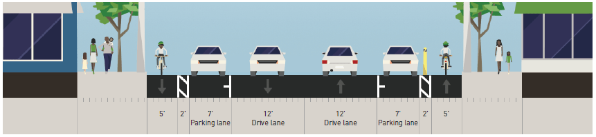
Alternative 2 replaces one lane with more on-street parking, and one lane width with a cycle track in each direction. At intersections, the parking makes way for a turn lane and transit shelters in the roadway. Unfortunately, the budget is not large enough to fully fund this alternative. Also, turning vehicles and other disruptions might severely reduce bus reliablility. But it’s not all bad news for buses: the shelter islands mean that “route 7 will stop in-lane to improve efficiency of loading and unloading,” in the words of SDOT Traffic Safety Coordinator Jim Curtin.
There is a parallel greenway under construction that provides another safe bike path north-south in the area. However, Rainier Avenue is, by far, the flattest pathway through the area, and a much more direct route of travel. And by the same argument, there is a parallel rapid transit corridor only blocks away on MLK. And much like the greenway is an imperfect substitute for Rainier for many ages and abilities, Link doesn’t answer all the transportation needs of the Rainier corridor.
It’s disappointing that the alternatives present this difficult tradeoff. Consider some possible changes to Alternative 2:
- Get rid of the new parking lane, and use the resulting 31′ of roadway for two general-purpose lanes and a turn lane to prevent delays from turning vehicles. Admittedly, this would omit the calming effect on the bike lane of a row of parked cars.
- Consolidate the two bike lanes into two-way cycle track, saving one 2′ barrier. The remaining 40′ of ROW could be divided into a 12′ NB bus lane, 7′ of parking, and two 10.5′ general-purpose lanes (wider than the 10′ lanes in alternative 1).
I asked Mr. Curtin about my second idea. “Design of protected bike lanes is a relatively new thing… Having a two-way bike facility on one side of the street can be problematic. Bicyclists have trouble getting to the bike lane from the other side.” He added that it can “lead to additional crashes, especially on a principal arterial with a record of crash problems.”
You can comment on the genuinely difficult tradeoffs at SDOT’s project website. The deadline is August 28th.
* Southbound transit times were unchanged.
I also proposed a 2-way bicycle facility to Curtin’s team for their NE 65th project. They weren’t interested. That project is pitting bikes against pedestrians by narrowing the sidewalk in places in order to fit a protected bike lane. SDOT needs to stop doing this nonsense.
I’ve recently started bike commuting more. I’m really getting tired of the fact that cyclists don’t have a lot of traffic separated right of way that they don’t have to share with pedestrians. It seems like the city is intentionally cramming cyclists and pedestrians onto things like the Burke, while providing ridiculous amounts of right of way for motor vehicle traffic. This pits “clueless pedestrians ambling around my bike highway” against “jerk cyclists screaming down the trail”. We need better traffic-separated right of way for both cyclists and pedestrians at the cost of motor vehicle right of way. I’m sick of cars being a first class concern, and bikes, walkers and buses being second class.
Tired and sick? Don’t like cars? Don’t like pedestrians? Don’t like to share? An additude adjustment would be recommended.
Hi,
I’m surprised at the negative comments from others about 2-way bike lanes. I live in Washington DC and we have a two-way protected lane (i.e. the lane is between the sidewalk and a row of parked cars) on a one-way street, which i use every day. we also have one-way “semi-protected” lanes going the same direction as traffic on one-way streets. by semi-protected, i mean that often there is just a row of plastic poles, in addition to pavement markings, between the bike lane and the traffic. I couldn’t tell you which design feels safer. to me, the biggest danger is pedestrians stepping into the bike lane while checking their Twitter feed.
I think the fact that it is one way makes it a lot safer. I’m not sure which side of the street the 2-way bike lane is. But assume that it is on the driver’s left. When taking a left (crossing the path) they don’t have to worry about oncoming cars. They only worry about pedestrians and bikes. If the driver is aware of the bike path, then they will assume that someone will be traveling the same direction, so they check behind them. A biker who is going against the car traffic is heading right towards them (can’t miss them). Dealing with the bikers is similar to dealing with pedestrians. You slow down, look both ways, make the turn. There really is nothing else to worry about when making the turn (making a left turn from a one way street is similar to making a right turn on a two way street).
Now compare that with a two way road (like Rainier). There are cars to the right (heading the same direction) and cars on the left (heading the opposite direction). Someone taking a left turn is focused on avoiding a head on collision (with another car). That is the first order of business. Just avoiding that makes things more dangerous. A biker heading towards them is treated just like a car. It is headed the same way, and basically seems like the same thing. But it is that bike that comes up from behind that is odd. Eventually people get used to it, but a driver is forced to look both directions for fast moving vehicles, and that is inherently dangerous.
Of course we also have a 2-way bike path on a one-way street, downtown on 2nd Ave, and it’s basically fine. As Ross says, drivers turning off of 2nd don’t have to worry about oncoming car traffic. Additionally, they don’t even have to think about bikes and pedestrians except at driveways: every proper intersection has a signal and a separate turn phase, and right-on-red is banned at all the cross-streets. Rainier is totally different: many of the intersections aren’t signalized, many left-turns aren’t protected, and there are lots of driveways.
It’s hard to think of a 2-way path along a road that’s really comparable to Rainier, with so many driveways and unprotected turns. Many paths have particular sections where you really have to watch out for turning vehicles from multiple directions (the path along Des Moines Memorial Drive has a few clusters of driveways; the Green River and Duwamish Trails have a few sections with driveways; the Interurban has the part along Linden). But few have so much turning traffic, so continuously, for so long as Rainier. You’d get no break from that stress. NE 65th would be sort of like that, too, though probably not as bad as Rainier…
“2-way bike path on a one-way street, downtown on 2nd Ave, and it’s basically fine”
Second avenue is awful and barely used at around 750 trips per day, which is about one fourth of the Fremont Bridge. It has more problems than solutions. The lane is almost always blocked off at some point for adjacent building related construction closures, parked cars block the view of the lane for drivers turning left, drivers still routinely turn left on red arrows, pedestrians stand in the lane to wait for signal changes blocking access for cyclists turning onto the lanes, it isn’t actually connected to anything (no bike network in Seattle), there are large cracks/gaps between the concrete slab that are perfect for puncture flats, and absolutely no signage for infrequent users – which is hugely important with the rise of bike share use.
The best thing about Second is that it teaches us everything not to do on a bike facility.
Bike facility usage, compared to the Fremont Bridge, is hardly a test of design quality. The Fremont Bridge and its approaches make a pretty lousy bike facility themselves (mitigated by their flatness and short length), but the bridge occupies a uniquely important location in the network, which accounts for its popularity. 2nd, as you mention, lacks connections to major bike routes. It’s in an important location, in the middle of downtown, but not a uniquely important location, as there are other streets right nearby.
I don’t think the difficulties of 2nd Ave “teach” us that it was a fundamentally misguided project. We could take construction closures in stride if we had a more robust network otherwise — but of course we won’t get there unless we take the first step. Something has to be first, and here it was 2nd Ave. Driver behavior around the ‘track has improved significantly since it opened, and because most of the downtown streets are one-ways there aren’t too many places to check for scofflaws. The pavement quality is, indeed, pretty bad, though hardly worse than average for Seattle. As for signage… maybe we could use some signs illustrating turn-box use?
So should 2nd be a two-way facility? I actually think it’s particularly useful going north, against the flow of car traffic, because 2nd and 3rd Avenues are the easiest climbs. Avenues to the west like 1st and Western leave you with really steep climbs up to the major routes out to the north. Avenues to the east like 4th have steeper blocks climbing out of Pioneer Square. 3rd will need lots of room for buses for many years still. 2nd really is a very important route for heading north. And with relatively few uncontrolled turns across it, it’s not such a bad one.
I think Broadway is significantly worse than 2nd, and I think Rainier would be a disaster with that design.
I don’t know if there’s data on this, but as a cyclist, I feel unsafe on two-way bike lanes. Cars simply aren’t looking for bikes coming the opposite direction as traffic. I constantly have to shout at drivers on 2nd Ave and on Broadway to keep them from hitting me. I know this is anecdotal, but I really think we should stop asking for two-way bike lanes. We need protected bike lanes that go the same direction as traffic.
Cars aren’t looking for bikes in protected bike lanes that go in the same direction as traffic, either. SDOT doesn’t know how to design PBL intersections yet. If you go to other places (Vancouver, BC being the closest example), their two-way PBLs feel much safer.
Dutch traffic engineers (who know more about biking than anyone else) are in the process of removing their two way bike lanes in most intersections. Two way bike lanes always create more confusing road layouts and are less safe. I don’t think we should be repeating their mistakes.
2 way bike lanes are horrible for everyone.
As someone who rides himself and his kids in 2 way bikes lanes, I disagree.
The first phase collisions are down 15 percent — but volumes are down 27 percent! That would mean that each car is actually now more dangerous! That’s not a clear-cut success.
The road diet removed a lane, but we also widened each lane from 11′ to 12′. Imagine if we’d actually narrowed the lanes to make them safer?
https://www.citylab.com/design/2014/10/why-12-foot-traffic-lanes-are-disastrous-for-safety-and-must-be-replaced-now/381117/
It’s unfortunate that collisions are only being measured on Rainier. How many additional collisions are now occurring on MLK, Seward Park Ave S, Beacon Ave, Lake Washington Blvd or any of the other alternatives to Rainier? The stats show that Rainier Avenue is now safer, but is traffic in all of Rainier Valley/Beacon Hill safer overall now? SDOT hasn’t provided that answer.
Thanks for this comment, Al. It prompted me to take a closer look at the data from Rainier, which resulted in this Urbanist post. SDOT really needs to reexamine the Rainier road diet..
https://www.theurbanist.org/2017/08/31/rainier-ave-road-diet-data/
Why the interest in a NB bus lane but not a SB bus lane?
I’m assuming that the traffic is worse that direction.
It may also be that people are more sensitive about delays on their way to work than from it.
It may be that the bus lane would be northbound in some locations and south in others, depending on traffic situations
You know, that’s a real interesting idea – having a reversible direction bus lane that’s dependent on traffic direction, like I-5 express lanes. Huh I couldn’t think of a way to implement them though.
Have one lane in the center of the street, with island platforms on both sides?
It’d work a lot easier with the dual-side-door buses Seattle’s planning to buy eventually.
I don’t think that would work very well. When the bus isn’t in the special lane, it would be in the left lane. Otherwise, a rider would be very confused (either get to the middle island or the curb, depending on time of day). So far so good, but then you don’t have a left turn lane. This means that buses (who aren’t in the special lane) would be stuck behind cars making a left turn.
The express lane idea works fine for just that — an express. I’m sure there are instances where it would make a lot of sense in the city. I’m afraid this isn’t one of them.
Gotcha. Forget about it then. As I said I couldn’t really think of a way to implement something like this. Just floating the thought
As a dedicated bike commuter who lives just off Rainier, I think I have to favor the bus lanes over the bike lanes. I would personally benefit greatly from the bike lanes (no more climbing Beacon to get downtown!), but the bus lanes offer much more commuter throughput. The truth is, thanks mainly to our topography cycling isn’t and will never be an option for the majority of commuters in our city. By comparison, buses offer a faster, safer and higher volume mode of transit. If we have to choose, I choose Alternative 1.
We need to move past this kind of thinking. Ignoring bikes on Rainier doesn’t mean that people won’t bike there, it just means they won’t be safe when they do so. We don’t let car speed trump bike safety, and we shouldn’t let bus speed either.
Totally agree. Why should cyclists have to take the long, hilly route while drivers get the direct, flat one?
Cities like Copenhagen and Amsterdam deliberately divert car traffic to longer, windier, less direct routes and prioritize active transport on the most convenient roads. Diverting car traffic onto MLK or 31st or over Beacon Hill would result in a few minutes’ delay for a driver. For a cyclist, it increases the transit time by more than 50%.
Absolutely. If the city is serious about moving us to a true multi-modal, sustainably growing city, we need to set SDOT to the “screw cars” mode and go the full mile. These half measures are just going to leave everyone unhappy.
But wouldn’t a continuous bike facility on Rainier change the topography significantly?
I agree that the scope of this project is too limited to open up bike commuting to a much wider range of cyclists but a full bike facility on Rainer to Dearborn would. That would take more vision than small segment by segment projects like this one. Tackling the Accessible Mount Baker project (Rainer and MLK junction) first probably makes the most sense but if we miss this opportunity for bike lanes here then a complete network becomes even harder to achieve in the future.
People talk about the topography but in fact there are relatively flat stretches like Rainier that would be great spines for a bicycling network. Of course Rainier is a main thoroughfare for a good reason: it’s the most direct route and there aren’t good alternates if you’re trying to *get* somewhere. Well, the same applies to bicyclists–especially with light rail stations on that corridor! Other examples: Broadway and 2nd Ave. Broadway doesn’t go all the way, 2nd Ave could hook up with the waterfront trail and Marginal Ave trail down to the West Seattle Bridge near Pioneer Square, but it doesn’t. Jackson has protected bike lanes under the I-5 bridge–why not go all the way to the waterfront?! These are examples where the topography isn’t the main obstacle to biking, it’s the lack of an interconnected network. Because, cars. And as Rainier Ave. Road Diet–Part I shows, despite the wailing and gnashing of teeth, drivers can easily adjust their trips and/or park somewhere else, and life goes on. Whereas protected bicycling networks save lives–and much more so than mandatory helmet use.
The tiny, 30 yard bike lane under the I5 bridge had always struck me as comical and cute (or insulting even).
But no one here is taking about volumes. My wife rides the bus up Rainier and rarely gets a seat even getting on at Orcas at 7:00am. I really don’t believe that most of those people (many elderly) will be mounting bicycles if we build a protected lane. They will still need a speedy mass transit option and I just won’t subordinate their interests to mine.
Regardless, all of this is moot, as was pointed out, because the proposed improvements stop well short of even freaking ORCAS. None of the bike or bus lanes will make any significant difference if they don’t extend at least to I90.
The creation of a two way cycle track on Rainier would be asking for trouble. For years the road has been a major thoroughfare. You would have to do major work — limit turns, add additional signals and the like — to even come close to making it reasonably safe. Even then, I wouldn’t bike it in the opposite direction. I would just ride in the main traffic lane and put up with people honking (while pedaling as fast as I can). Or I would bike on the side streets.
In general, this is going to be common theme with these projects. The combination of our tough geography as well as mixed up grid make for tough choices. On the one extreme, you have Eastlake, which is a major bike corridor that doesn’t have a reasonable alternative. On the other end, you have 45th, which has lots of alternatives for bike travel (and isn’t very good in general), and is far more important as a transit corridor.
This sits somewhere in between, but in my opinion, is much closer to 45th. There are biking alternatives. Along with the one you mentioned (east of Rainier) you can also bike west of it. From Charleston down to Henderson (beyond this project) there are various ways to get there, like so: https://goo.gl/maps/B5armkxDr7K2. This is where the bike path should be.
It is north of Charleston where tough decisions have to be made. You either go on Rainier, MLK or up a hill. It gets even worse as you get close to the freeway. Something has to give. There side streets that go over the freeway, but they become a pain for riders. I don’t see an easy way to accommodate both transit and bikes.
With all that being said, here are my recommendations:
1) For this section, build alternative bike routes. They are there, and they are reasonably flat.
2) Take the parking lanes. Some streets (e. g. Denny) haven’t had parking for years. You can make a good argument that no major arterial should have parking. This would not only free up a lane for transit (in some cases) but allow regular car traffic to flow more freely. People pulling in or out of parking spaces routinely slows down traffic. If you there are side streets nearby (and there are for Rainier) then just take the parking lane.
3) Leave the tough work (what to do farther north) for another day.
I would place the section of Rainier between Charlestown and Orcas much more in line with Eastlake in your typology. The alternative bike route you link to is fine for some but it has two short sections with grades >10% (the first section of Letitia Ave south of Rainier and Hitt’s Hill on Renton Ave south of Husdon). Those aren’t ride-able for an average citizen on an average bike but Rainier Ave would be.
I don’t think the average citizen will ever feel comfortable riding on Rainier. You can add bike lanes, but it is still an arterial, and lots of people (myself included) will avoid it. We might ride for small sections (if it is unavoidable) but not for a long distance. I would rather go up the hill, even if it means walking the bike during the steep sections.
Side note: I have no idea why Google says the route is “mostly flat”. You are right, it has hills. The weird part is that Google does a good job of listing the hills if you shorten the route (e. g. https://goo.gl/maps/oPH4bEJNKa32).
Question — You say Rainier is flat, but Google says otherwise: https://goo.gl/maps/h68eMhpfgLz, as does a look at the topo maps. It is still probably better than the alternatives (if there were no cars) but not really flat.
When I had a bike before Link, I always used MLK because it was flat and wide and doesn’t have as much traffic as Rainier. Can we retrofit a cycletrack onto MLK now? That would take the pressure off Rainier.
Good question. I was thinking the same thing. Adding a bike lane on MLK would make more sense than adding it on Rainier. Add bus lanes on Rainier, and bike lanes on MLK. Works for me.
Yes, the obvious choice that was made here was for parking, rather than getting people safely around the neighborhood.
I had similar thoughts. There is clearly enough room for bike lanes, provided all parking is removed. I guess private property storage is more important than transit speed or safety for vulnerable road users.
“Transit takes so many subsidies from the government!”
Like cars don’t take some of the most valuable and expensive ROW in the state for free parking as well? I wonder how much money those thousands upon thousands of free parking spaces in the city should be pulling in if the city charged for them what they were worth.
From what I have read, the general consensus among urban planners is that 2 way cycle tracks should only be used when there are limited turns from on-coming traffic. This means that the cycle track on Westlake is good but 2nd Ave and Broadway are bad. Personally, I feel safe on all 3 but it’s definitely a much more pleasing experience being on Westlake than the others. I don’t live or work anywhere near Rainier ave, so I do not have a strong opinion on its best use. My own personal take is that we live in such a hilly city that every possible “flat” road we are not using towards cycling is a huge opportunity lost. I have no doubt that buses currently move significantly more people through that area but safe bike infrastructure on that road would be revolutionary and it could help a lot more people reach the light rail..
I like my car and enjoy driving very much. But for those reasons, for trips where I don’t need it, I generally leave the car at transit stations, and ride buses or trains from there. Every now and then, I’ll have to use a cab. Or car-sharing, when I finally get a smart-phone.
So I’m wondering how fair a comparison this is with people who substitute bicycles for an automobile, for travel around places where there’s reliable transit. Especially with new bike-share provisions. I think buses will always have limited capacity for bikes, and also that streetcar and light rail have better potential.
I think LINK can trade seating for bikes and standing room in some cars. Also, like in Stuttgart Germany:
https://www.flickr.com/photos/43315334@N07/25381820415/in/dateposted-public/
Though notice the toothed cog-wheel track between the running rails. Wonder if Tacoma LINK might need a couple of blocks where tracks do a 90 degree (well for real results, it should look like one on a map!) and breath-taking traffic blocked climb to Division.
But especially for Rainier Avenue, I wonder if best solution is to put the money into more frequent bus service, with every reserved lane and preempted signal possible. Is any of this a fair comparison?
Mark Dublin
Hey! What about bus operations? We’ve officially declared this street in the Transit Master Plan to be a Rapid line!
Rather than define the alternatives by mere cross-sections, we should be looking at cross-sections at bus stops and in between bus stops separately for starters. We should be as concerned about bus stop geometries and amenities and pedestrian waiting area footprints as much as we are concerned about PBLs.
SDOT is approaching this as a PBL and traffic calming assignment first. It’s not! A paradigm shift to first designing bus stops and operations is needed. Why not have the blocks with bus stops in either direction be exclusive, with queue jumps at the ends of those blocks, for example?
I don’t think any alternative should be chosen until a full street design concept for Rapid bus operation is developed and refined. Otherwise, we are left to constraining our buses to fit into what’s left over once we’ve agreed to do for all the other modes. I think that buses are being treated as afterthoughts right now.
I agree. It is like the right hand doesn’t know what the left hand is doing. These are all laudable goals (quieter street, better bike paths, better transit) but they all need to be designed together.
My personal hope is that they prioritize buses first over bicycles. Bicycles can (and do) ride on the sidewalk, or can take alternate routes, and are a small segment of commuters. Most bicyclists here have to be fairly athletic. A bus lane helps transit riders, and those who are less physically able who often rely on transit. I don’t see why they can’t get rid of the parking and have both a bus and a bike lane. That said, there sure are a lot of bicyclists that don’t use the bike lane anyway, so I’m not sure it matters that much.
Exactly. And if a few people who are biking (or walking on the sidewalk and are knocked over by a bike) die because they didn’t have a safe route to use, so be it. The important thing is that we made the bus go slightly faster.
They have a dozen quiet streets in Rainier Valley to choose from. The arterial is the only street mass transit can use, and it has thousands of existing riders per day and the potential to pick up the majority of trips in the valley if we build it right. All those people shouldn’t wait behind cars because we want to squeeze a cycletrack on Rainier for bicyclists won’t choose another street or use the sidewalk.
I can play that game too, Andres:
Let’s ignore the fact that faster bus service gets people out of their cars. If a few people die because there are more cars on the road, who cares? At least we have a bike path that a handful of people use.
+10000000, Ross and Mike.
the bus lane will become the default place for people to ride their bikes so that buses will be slowed by bikes, putting bike lanes in gets the bike riders out of the way of buses and vehicles. the article points to the mass transit spine for the region is on MLK, the 7 is not a fast route, it’s a local milk run, those who need to get to farther out destinations can choose light rail
Milk run? Please.
Let’s say I’m at Rainier Avenue and Othello and want to get to Rainier and Jackson. That is about a 20 minute bus ride, and worse if there is traffic. That is hardly a milk run.
Oh wait, I’m supposed to use Link! I get it, so now I walk over to the Link station (half a mile) then take Link to Mount Baker. Then I make a transfer once described as “awful” (https://seattletransitblog.wpcomstaging.com/2012/04/18/the-awfulness-of-mt-baker-station/) followed by getting on the 7. This is if I’m on Othello! If I’m on Kenyon, it is a 20 minute walk. It is absurd to suggest that Link serves all of those riders.
There is a reason why the 7 is so popular. It is the most popular non-Rapid Ride bus because it serves a vital corridor. That is why the city wants to make it a RapidRide bus, if not a BRT bus. It should be made faster and one way to do that is to give it its own own bus lane (and no, the bikes shouldn’t be allowed to use the bike lane).
milk run was probably a poor term, but it is a local bus as in it makes a lot of stops and serves an area with a lot of destinations. the trip you describe is a local trip, about 5 miles long. My point was that people on bikes use Rainier and if a bus lane is added they are still going to use Rainier but ride in the bus lane. Having bike lanes helps all traffic, not just people on bikes
keeping bikes out of the bus lane is absurd unless they are given a dedicated space to ride and it’s legal to ride in the bus lane http://sdotblog.seattle.gov/2013/06/28/its-ok-to-ride-a-bike-on-the-sidewalk-but/
>> it is a local bus as in it makes a lot of stops and serves an area with a lot of destinations.
Right. Another term for this might be a very well performing bus. The type of bus that most buses wished they were. This is 2016 data, but at that point the 7 was a top three bus, surpassing many of the special RapidRide buses: http://s3.amazonaws.com/stb-wp//srv/htdocs/wp-content/uploads/2016/08/08221717/Screen-Shot-2016-08-08-at-10.16.52-PM.png
Who cares if it is a five mile trip. Why should a longer trip get priority over a five mile trip? A bus that is stuck in traffic is a slower bus. A trip that should take 20 minutes takes 30. Thousands of riders are forced to endure bad traffic.
Adding bike lanes won’t fix that. It will certainly make the situation better for the handful of people who bike there now (as well as lots more who are considering it) but it won’t make things faster for the many more who ride the bus. A few will ride in the bus lane if it is added, but a lot won’t. They will ride in the general purpose lane, either there or on MLK. Or they will ride the side streets.
Bus service on MLK is not nearly as important as bus service on Rainier. No one is talking about adding a bus lane there. But they should be talking about adding bike lanes there. Add bus lanes on Rainier, and bike lanes on MLK makes the most sense.
a shorter trip has less possibility of being delayed, for longer trips the benefits of light rail might outweigh the transfer penalty but for two destinations along Rainier the 7 will always be the best choice whether the trip takes 15 mins, 20 mins or 30 mins.
for bike advocates these proposals are either huge or literally nothing. it’s nice to think about bike lanes on MLK but it’s not part of the proposal. people have been talking about bike lanes on Rainier for a long time, it’s unfortunate that this is being presented as a choice between a bus lane where bike riders don’t exist or bike lanes.
don’t forget the whole point of this project is to increase the safety of the street. if a bus ride takes 5 mins longer but overall there are fewer crashes than the project will be a success
>> it’s unfortunate that this is being presented as a choice between a bus lane where bike riders don’t exist or bike lanes.
Yet that’s common, and it is wrong. Just to be clear, there are areas where that is our only choice. Eastlake is a good example. Unless you spend a huge amount of money (and build a bike pah along the waterfront, which would require purchasing access) you will have to choose. In that case (as I said above) it makes sense to prioritize bike access, as it helps complete an important connection (around Lake Union).
But this is not one of those times. We are being presented with a choice that is purely political. The city is basically saying “here, you bike and transit advocates fight over this bit of land”, while completely ignoring MLK next door. If you step back a bit, it is obvious that this is bullshit. The best solution is pretty simple:
1) Have two bus lanes, two regular car lanes and a turn lane on Rainier. This will allow both regular traffic and bus traffic to run faster on Rainier. If you happen to be driving for miles on Rainier, you get in that left lane, and just cruise. If someone is turning left, they get out of your lane. If someone is turning right, they get out of your lane. The bus does have to occasionally wait for drivers turning right, but it is still a major improvement.
2) Add bike lanes on MLK. Yes, this makes it slower, but again, Rainier is faster. The 106 is slowed down, but it isn’t clear whether we should have a bus running on MLK, anyway. If you add a bus lane for Rainier, then maybe the best thing to do is send the 106 there (or do something else with it). When we add a stop at Graham Street, the distance between stops shrink, and so too will ridership on MLK. If we do keep a bus on MLK, then it shouldn’t be given priority.
Now consider the alternative:
1) We do nothing for MLK, but add bike lanes on Rainier. From a traffic perspective, the best you can do is two general purpose car lanes and a turn lane. The 7 is an enormously popular bus, which runs every 12 minutes, all day long. Since it is a RapidRide+ bus (slated for improvements) it is likely to run more frequently soon. This means that cars have to stop and wait for the bus constantly. So both the buses and the cars would be stuck.
Yet the city wouldn’t be able to fix the situation. They could add bus lanes for MLK, but that would be nuts. We would just live with a situation that *only* the bikers like, and to me that is crazy. This is too important a corridor for transit. Keep in mind that the 7 has ridership that is about twice that of Link in the valley. Some of that is folks riding up the road (on Jackson) but still. Add together the four Link stops in Rainier Valley and they are about half that of the 7.
If ST was thinking of adding a second line down Rainier — which would make sense given the popularity of the 7 — then we wouldn’t even be having this conversation. No one would say that we need to add bike lanes instead. Well, the same is true for bus service. The 7 should be made faster — not slower — and bike lanes should be made on MLK.
Ditch the parking and there is enough room for people to bike safely (with barriers from traffic) and for two GP lanes in each direction and a bus lane.
Let’s stop pitting the mobility of people who take the bus against the safety and mobility of people who bike against each other.
If we kill the parking everywhere on Rainier, can we have both? Honestly, the total number of heavily used spaces is very very low, limited to a couple small business districts. I live in the neighborhood and drive Rainier a lot. From MLK to Henderson I mostly see parking lanes on Rainier that nobody uses. Because no one wants to get out of their car into Rainier traffic for the same reason people don’t want to bike nor walk along it.
Ditch all the parking outside Columbia City, Hillman City, and Rainier Beach cores. Wasted space. Just idle asphalt. Turn it into bike and bus lanes.
Not without compromises. It’s a 52 foot corridor. Two bus lanes and two arterial traffic lanes are 24 feet for the bus lanes and 20 for the cars. There isn’t room for a ten foot turn lane (a compromise… the usual deal on a road diet is going from 4 to 3 not 4 to 2).
So you have 8 feet left exclusively for bikes. That’s either 6 foot bidirectional lane with 2 feet of separation or 8 feet without separation, or an unseparated 4 foot bike lane on each side. I don’t think either of these is a great option. You could probably do some sort of Jersey barrier for partial separation, but it wouldn’t be ideal.
I suppose we could take from the sidewalks, but my recollection is that the sidewalks on Rainier are already too narrow, so I wouldn’t really support it.
I think the logical compromise is one bus lane, two bike lanes (on opposite sides of the street), two general purpose lanes and a turn lane. One bus lane is better than nothing, and apparently is a good enough idea for the city to propose it.
Personally, I would favor two bus lanes, two general purpose lanes, a turn lane and no bike lanes or parking lanes for Rainier Avenue. Then I would convert a general purpose lane (both directions) on MLK to bike lanes. Traffic would end up being bad on MLK, but so be it. MLK is already very regulated as far as turns are concerned (because of the train) which makes it inherently safer for bikes. One full lane is plenty of room to build an actual barrier, which would make it much safer as well.
That’s basically option 1, but with the 8 feet of parking replaced with two bike lanes. There’s only 4 feet of budget for each one, including separation. I’m fine with getting rid of parking (although I do sympathize with the merchants who claim that this will impoverish them). But will it satisfy the cyclists the lanes are supposed to serve?
What is the best practice for a bike lane next to a bus lane? Bus on the inside, so a big gap between door and curb, and (at least at bus stops) no separation [would this be ADA compliant?], or bus on the outside, sandwiching bikes between traffic and bus? Neither sounds ideal.
@William “That’s basically option 1, but with the 8 feet of parking replaced with two bike lanes.”
Yep.
>> What is the best practice for a bike lane next to a bus lane? Bus on the inside, so a big gap between door and curb, and (at least at bus stops) no separation [would this be ADA compliant?],
I think so. That is the way Roosevelt/Eastlake will work.
I should have added above that I think any street parking on a major arterial has been out of date for at least twenty years, from both customer and merchant’s point of view.
The time one customer – and not necessarily a patron of the business they’re parked in front of- spends parking and leaving- could let a lot a lot of over ones arrive by walking and bike. And transit if all it competes with is street parking.
However, I think right now, there might be a major swing to transit if there were parking structures for motorists built along with each line, in places where connecting transit is still scarce. Any architect: Structure and poison-chemical-wise, how possible is it to convert today’s transit parking garage into tomorrow’s passenger home address?
Mark
And yet merchants consistently disagree with this assessment. Perhaps they are misguided, but generally speaking, I’ll take the opinion of someone who has skin in the game over some academic study that has no real stake in being right.
But the merchants are often wrong! I don’t know why they consistently over-estimate the percentage of customers who drive. Maybe because that’s the way it was when they started business. But today urban commercial streets get a lot of business from pedestrians, transit riders, cyclists.
Eliminating on-street parking can deal with a lot of these geometric issues. But sometimes it can’t, and often it’s politically impossible. Then the city needs to figure out which streets should prioritize transit and which streets should prioritize bikes, so there can be good networks for both.
It really depends on the street. There are some places where the blocks are long, and the side streets are arterials that also don’t contain parking. This means that someone who parks has a long walk (several normal blocks) just to get to the business. I could see that hurting business. In this case, i don’t think that is a problem. There are plenty of side streets.
You also have trucks that drop off stuff. It can make their jobs tougher, which can trickle down to the businesses. In that case, the answer is fairly simple — allow them to use the bus lanes (within designated sections) during certain hours. This practice has come under fire here, but mainly because the limits for rush hour are way too small. But from, say, 10:00 to 3:00, it is OK. That is the type of compromise that makes sense, and can work out just fine.
Option 1. Buses blocking traffic will just anger the already angry drivers on Rainier and make them swerve around the buses. Drivers already use the center turning lane as a passing lane if they’re angry today.
I agree with much of what has been said in the comments already but will add a few thougths:
– 2 way bike lanes anecdotally feel more dangerous (as a cyclist), and I’m happy that the city is limiting their implementation. I would also add that they are uncomfortable for cyclists as their usage increases, since it becomes very difficult to pass. The 10′ 2wPBL that the author proposes would be uncomfortably narrow (I think this is narrower even than the narrowest section of the BGT under the new bridge at UW). Andres- can you provide specific examples and safety analysis of “properly designed” 2WBPL intersections? perhaps the issue is not SDOT’s lack of knowledge but lack of funding? or a lack of education of American motorists? I am genuinely interested and would happily work to educate sdot if that’s really what’s needed.
– regardless of topography, greenways seem like a sub-par alternative for bike commuting as the crossings are necessarily less efficient. (On an arterial, theres a significant chance that you will be able to keep momentum through a green light, whereas crossing an arterial from a greenway can take several minutes even with rapid flash beacons)
– I agree with Tim F and Chris I: this article may have been better titled “ranier ave must choose between parking and modern street design.” Without parking, the 52 feet of roadway could easily accommodate two 12 foot travel lanes, a 12 foot bus lane, and two 7 foot protected bike lanes. This seems by far the safest and most efficient option since cars wouldn’t block sight-lines of the bike lane, and there would be no parking maneuvers to slow down traffic/busses. Intersection design would be a bit more difficult if you can’t trade parking for turn lanes, but I’m sure that with a little creativity we can have our cake and eat it too. (for example, 10′ SB right turn, 4′ bike, 12′ SB travel, 10′ NB travel 12′ NB bus, 4′ bike. If the ROW is a bit bigger at the intersections, it might get easier, or there might be ways to combine bike/bus/travel lanes to make way for turn lanes, or maybe the intersections would just have to only allow either left or right turns)
– Has there been any investigation into BRT lanes that switch direction with rush hour? I’m not sure if it’s applicable in this case, but it may be a solution in many cases with restricted widths of ROW. If anyone knows of domestic or international examples of this, I’d be very interested.
> Without parking, the 52 feet of roadway could easily accommodate two 12 foot travel lanes, a 12 foot bus lane, and two 7 foot protected bike lanes.
That’s basically a decision to give a horrible bus riders in at least one direction to satisfy the tiny fraction of travelers who (1) use a bike and (2) won’t just ride in the GP lanes or on the sidewalk anyway.
> Has there been any investigation into BRT lanes that switch direction with rush hour?
The biggest problem is that you either need buses with doors on both sides, or need to deal with passengers getting off on the wrong side, which, at a minimum, requires space.
I think your assumption that the bus ride would be “horrible” is likely untrue. I based that suggestion of a road plan based on SDOT’s: none of their suggestions included two bus lanes. I suspect that with parking removed and well designed intersections, the SB busses would move more smoothly. That said, i have never personally experienced morning rush hour on Rainier.
Your comment about these projects trying to “satisfy the tiny fraction of travelers who (1) use a bike and (2) won’t just ride in the GP lanes or on the sidewalk anyway” is really infuriating for many reasons. Especially in a less wealthy neighborhood, the bicycle can be the lowest cost option for people to get to work or around town. The working hypothesis for the small size of the mode share is that there is no safe bicycle network — exactly what this project has the potential to solve. There may be a few especially brave souls that would take on the GP lanes on Rainier, but to suggest bicycle usage on sidewalks is ridiculous: it seems like common knowledge that this is uncomfortable for pedestrians and more dangerous for the cyclist– that’s why most other major cities make it illegal. (I would gladly trade seattle’s helmet law for a no adult bikes on sidewalks law, but that’s a totally different conversation)
As for the 2-way bus lanes, wouldn’t the city need to buy rapidride busses to serve this corridor anyway? Would it really be too much different in cost to buy ones with doors on both sides?
The approach is wrong.
Must choose between storing possessions on the roadway and moving people on the roadway.
Ever notice that none of the cross-sections show a 7X passing a 7 local?
It makes me wonder how well the buses would even pass each other once a lane is gone. SDOT doesn’t apparently want anyone to know if it’s possible or not.
I’ve always wondered why there can’t be a bus + bike auxiliary lane that accommodates both (i.e. bikes just travel in the bus-only lane). The bus drivers are trained expert drivers and cautious enough to be wary of cyclists. And cyclists probably travel about the mean speed of busses, so while they are in transit, leapfrogging is probably at a minimum. Anyone have any thoughts on this?
it’s legal to ride bikes in all transit lanes in Seattle unless specifically banned. SDOT just doesn’t advertise it usually
Why can’t bikes use the bus lane?
Route 7 is a serious high ridership service, even if not branded as RapidRide. It provides 10-minute headway service with articulated trolley buses. Seattle has already made investments to move the buses better (e.g., stop consolidation, signals, bus bulbs) and provided some real time information. It probably attracts about 12K weekday rides. It has much multifamily housing and villages; it should have frequent reliable transit.
The headline is solid. Can priority be provided to two modes on the same arterial? Both buses and bikes sorta need to be at the curb. Can the bike facilities be on another arterial? Both MLK and Rainier and diagonal.
It would be great if trolley bus overhead and a terminal were funded to extend Route 7 to the Rainier Beach Link station on MLK Jr. Way South.
I have biked on Rainier. It is not an 8 to 80 roadway.