
Sound Transit has another online open house up, now with more details on station locations and elevation. We’ve covered the alignment alternatives in previous posts, so let’s focus on the stations. Two notes to start with: first, if you like mezzanines, you are in for a treat! Second, opening dates are pushed out past 2035 due to COVID, though that could slip further pending reprioritization discussions at the board level.
Links go directly to station images or pages where appropriate.
North of Downtown
- The 15th Ave option in Ballard remains superior. It would straddle the arterial, allowing riders to avoid crossing 7 lanes of traffic to get to and from the heart of the neighborhood.
- Sound Transit imagines that buses would detour to 14th to serve the station; yet another reason why 14th is bad.
- If you want the 15th Avenue elevated station in Ballard, you’ll also get a 15th Avenue station in Interbay. Straddling the arterial improves access from the Queen Anne side.
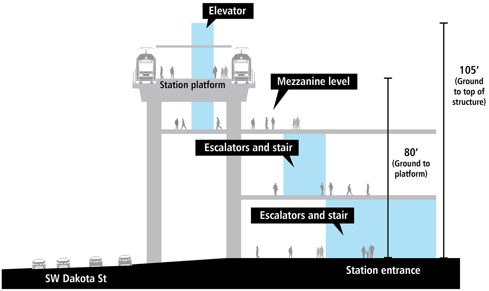
- (For context, 50 feet from ground to platform is roughly TIBS height. Mezzanine-less Mt. Baker is is 35 feet.)
- I don’t have much to say about Smith Cove other than a couple of the options would be bad for the Taco Time.
- The Mercer St. option at Seattle Center has better bus transfer opportunities than Republican, but it’s connected to 6th Avenue through downtown
Downtown & SLU
- Harrison Street in South Lake Union has better transfers to SR 99 buses like the E Line
- A Westlake station south of Denny has better pedestrian access for Belltown and slightly easier transfers to the 8. (Imagine a station directly under Denny & Westlake that let you emerge at any corner!)
- No new details on Chinatown-ID, where four options are still on the table.
South of Downtown
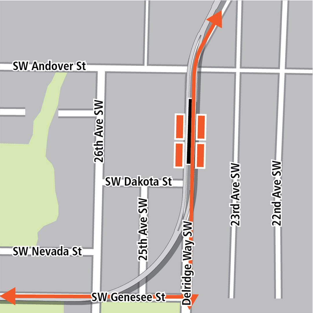
- Check out this absolute unit of a station in Delridge. Two mezzanines! At 105 feet tall, would it be the tallest building in West Seattle?
- A reasonably-sized station straddling Delridge Way, on the other hand, would have excellent transfers to RapidRide H.
- An elevated station at Avalon would have decent bus transfers but would condemn yet another Taco Time.
- Keeping Avalon above ground but with a short tunnel to bury the Alaska Junction station seems nice, but expensive.
Have at it in the comments.
It’s rather noteworthy how the vertical station profiles showing heights and levels is missing for any below-ground station. This exercise appears to focus only on above-ground visual impacts. While those are significant and revealing, it’s the below-ground layouts at many stations Downtown and SLU that will affect the cost and schedule more.
The difficulty of excavating and building deep subway stations around skyscrapers remains a big elephant that is being ignored.
Looking at West Seattle in particular…
Delridge: agreed, the Delridge Way station is easily the best of the 3. The most important thing here is to axe the Andover (“Nucor”) station which is in a terrible location.
Avalon: The tunnel station is the best one here, right in the middle of the Avalon Triangle with entrances on all sides. Excellent bus and pedestrian access. The “retained cut” has poor entrance locations. The elevated one looks fine but is opposed by all of the local neighborhood groups due to impact on existing homes. My main feedback would be to include a new Taco Time in the station design. We can’t afford to lose the West Seattle Taco Time.
Junction: both elevated stations have serious problems. However, my understanding is that the ‘short tunnel’ option is the favorite here which has a nice location at 41st and Alaska, and won’t require nearly as much 3rd party funding as a longer tunnel.
The junction is a terrible location for light rail, the roads are too narrow, and there is no practical way “out” of the junction for destinations south, the WSEA chamber has this fantasy there will be a sex in the city NYC style stairwell in front of easy street, that magically whisks shoppers into the neighborhood.
Junction: both elevated stations have serious problems.
I agree. Whatever happened to the original plans? You know, the ones that people voted on, and approved? If memory serves, the train turned on Alaska Street, then ended a block or so before The Junction, putting it right smack dab in the middle of what little urbanism exists in West Seattle. Instead this will be closer to the golf course, the single family homes nearby, and auto repair stores. This seems like it is trying to wipe out property (and cost more) while simultaneously providing a weaker station.
Or maybe it is all being done so that the tunneling option looks like the only reasonable choice. It is as if Sound Transit is trying desperately to get Seattle to pay for a decent option in West Seattle, instead of building one themselves.
First of all, I’m not speaking for JUNO here but here is my understanding based on second-hand accounts. JUNO wanted the station at Jefferson Square between 41st/42nd (i.e. as close to California as possible without disrupting California). And obviously they want a tunnel. Another problem was when ST started doing the engineering they discovered they couldn’t fit the elevated station between the buildings on Alaska as was originally planned. So the representative alignment was dead a while ago. That’s why the 41st/42nd elevated track just plows right through the LA Fitness, it can’t be avoided.
So given that background the elected leaders asked Sound Transit to draw up some short tunnel options, which is how we ended up with the 41st/42nd Ave tunnel stations. A tunnel is being built. It’s as close to a done deal as there is at this stage in the game. And a LID will be proposed to pay for it if other third-party sources are not found.
From a transit advocate perspective the tradeoff needs to be accepted because a blessing from the Junction businesses is good for everyone. Plus the tunnel stations are pretty good in terms of location and potential for future extensions to the south. If the station was elevated it’s never getting extended because they will never be able to muster up the political will to plow through the neighborhoods to the south of the Junction.
Another problem was when ST started doing the engineering they discovered they couldn’t fit the elevated station between the buildings on Alaska as was originally planned.
How the hell did that happen? Why didn’t they catch that before people voted on this? That is outrageous, and amounts to a giant bait and switch.
All of the options look bad. The preferred Fauntleroy option is too far east. The other elevated option is way to disruptive (wiping out a bunch of property). The big tunnels are way too expensive, which leaves only the short tunnel. That is still not as good as the original plan, while being more expensive. Yet is the best option on the table.
I sure as hell don’t want to pay more for the West Seattle project (which is a terrible value as is). That leaves the people in West Seattle to pay more this thing. Good luck.
Credit (or blame) where due: Seattle Subway criticized the original plans for West Seattle because they did not orient the Alaska Junction terminus in the direction of future expansion in an ST4. And Sound Transit listened. (link: https://seattletransitblog.wpcomstaging.com/2019/03/26/a-better-elevated-option-in-west-seattle/ )
Joe Z is exactly right about the political impossibility of extending an elevated line through West Seattle. So Sound Transit’s current preferred alignment offers the worst of both worlds: an elevated line that will both (1) bulldoze its way through blocks of houses and a few large new apartment buildings, and (2) never actually be extended to the south.
Yes, Will is right, that was the #1 piece of feedback they got in round 1. The other thing they tried was to go up Oregon St with the elevated track but that resulted in a TON of community opposition which further tipped the scales in favor of a tunnel.
It was always obvious to me from the very beginning that West Seattle would get a tunnel. There’s no way for them to build an elevated line without knocking down dozens of houses and other buildings. If you thought Surrey Downs was a battle, this would be WWIII. It’s either tunnel or nothing at all for West Seattle.
@RossB agreed, a tunnel is a horrible idea for West Seattle. I don’t know why Sound Transit keeps suggesting it as if it’s actually a real idea and teasing West Seattle with the prospect of it.
1) Who is going to pay for it. Is West Seattle really going to be happy with a prospect of another tax??
2) The constructions impacts of a tunnel are much larger than people think. I’m not sure why people keep thinking it’s ‘no impact’. It takes much longer to construct a tunnel plus the stations involve blocking the road for many years.
3) Any expansion down to Westwood is impossible with the high costs of tunneling.
The Junction is out of the way and at the top of the massive hill, it was always going to be a logistical challenge to get a station there. It will be an even bigger logistical challenge to extend the track from the Junction farther south. I doubt it ever happens. If the line does ever extend south they will split the track at Delridge and continue from there.
RossB: The Fauntleroy option is not a bad one. The “center of mass” of development seems to have shifted eastward from California. That’s where the new apartments have been going up, and that’s where there are strip malls just begging to be redeveloped. While the walk to the Junction farmer’s market is further than I would like, most of the daily riders will likely be going to/from apartment complexes and businesses somewhere between California and Fauntleroy, as after a block west of California it is single family homes. Finally, there’s gonna be less objection to the El train above Faultleroy with larger structures on either side than, say, the El train cutting through a low density area requiring demolishing multiple structures.
Unfortunately, the WS end station issue is not better resolved with this ST round of feedback. This merely flushed out what has already been proposed.
I personally think that — given the huge amount of construction and valuable development along Alaska Street — moving the station to be along Oregon Street (some block between 39th and 42nd Ave SW) is the way to go. The station can be added into the hillside like Downtown Bellevue, and the tail track can extend to California in a shallow tunnel (that doesn’t have to accommodate a station). Closing Oregon Street partially or fully for a few years also has an advantage because it won’t be as disruptive as where the construction zone will be for these station location options.
Of course, ST picked the constraints and now we are left with some really problematic options. If they would open the concept up by revisiting station locations that can be a block or two away, a large cost and construction hassle can be avoided.
It’s politically hard and costly to take residential parcels. However, this is what going all the way into this small area requires. It is a matter of which properties get demolished rather than if.
The Fauntleroy option is not a bad one. The “center of mass” of development seems to have shifted eastward from California.
Yeah, sure, there are apartments there. But a handful of apartments doesn’t make for a good station. If this was just a station on the way (e. g. Roosevelt) then it would be fine. But it isn’t. This is *the* station for West Seattle. This is why they didn’t take the cheaper approach and just run down Delridge. This station is supposed to be in a vibrant, attractive area. The type of station that gets riders from outside the area all-day-long, especially in the evenings. This is what Capitol Hill Station is (right in the middle of things). It is what the U-District Station is (a block from The Ave). There will be people — including me, an old fart — who will go there just for fun. But I’ll think twice if I have to walk through this sort of thing: https://goo.gl/maps/kov98bT8Hw8sdCmv8.
Then there are the buses. If the station was really close to the Junction, you could send the C straight on California to Admiral. Now, after spending all this money, the buses will still serve the Junction, *and* make a turn to serve this station. There is no way a bus like the 128 is going to continue on California, which means that riders are left with a two seat ride, just to go a mile or so on the main commercial strip in all of West Seattle (https://goo.gl/maps/gYqPUs5oo3gdT9jG9).
It is just not good. The entire West Seattle line becomes suburban in nature (with West Seattle as a bedroom community). It is like commuter rail, right in the city. West Seattle has always been isolated from the rest of the city because of its dependence and glorification of the automobile. Light rail could bridge that gap. This won’t.
I agree with Ross. One of the most powerful things about Link station at the Junction was it allowed for the C to run straight to Admiral. Alongside the Avalon station, it will allow for a really strong north/south network in West Seattle. If the various bus lines are going to need to divert to connect to Link, then we might as well just stop at Delridge and just build a bus transfer facility.
I’m left scratching my head why ST wants so many mezzanines. As much as I like center platforms, it would seem cheaper and less impactful to have two side platforms at some if these locations. Unless a station is straddling a roadway or the track has to be way above the ground, why have them? After all, mezzanines as shown here seem to be requiring for extra sets of stairs, escalators and elevators that would be required for side platforms anyway. This is a huge design departure from the layouts of many soon-to-open ST2 stations.
I can’t even begin to think about how much I’d dread transferring to Link at many of these stations.
Generally I agree, but for 15th it does appear to facilitate elevated crossing of 15th, and that seems very useful (and perhaps could be improved to also include an entrance north of Market). If that station really does need to be that high for the fixed bridge approach, layering in a mezzanine shouldn’t be driving that incremental capital cost.
I’m not sure that’s correct that mezzanines generate additional vertical conveyance cost? It should actually decrease the need for redundant VC for ADA compliance, because if one elevator is out, customers can be directed to use the mezzanine to access alternative VC.
The transfer will be time consuming, but if that station really needs to be that high, I’m not sure what can be improved?
I’m left scratching my head why ST wants so many mezzanines.
I agree. There is tremendous station bloat in this thing, while cheap decisions are made about station locations.
15th in Ballard is a good example. Yes, it is a pain to cross 15th. It is also a pain to cross Market. Yet the current location spends a lot of money avoiding the former, while doing nothing for the latter. If the station straddled Market, then it would be easier to access from the north.
This has ramifications for the buses. It is quite likely that a bus coming from the north on 15th will turn on Market, and head towards the main part of Ballard. That means the bus stop will continue to be on the north side of the street.
I’m not saying I would spend millions so that people can avoid crossing the street. I’m saying it doesn’t make sense to spend millions for the extra mezzanine while ignoring the other issue.
The contrast between this system, and the most popular transit system in North America is striking. In Manhattan, the avenues are very wide (not unlike 15th). But if you want to get north, you access the train on one side of the street, and if you want to go south, you go to the other side. There is no mezzanine on a typical stop (what we would call “station”) in Manhattan, even though they have way more people, and way more riders.
The obsession over mezzanines contributes to the overly high costs of American mass transit systems. See item 2 here: https://pedestrianobservations.com/2019/03/03/why-american-costs-are-so-high-work-in-progress/.
For whatever it’s worth, I recall most Toronto subway stops that are actually underground having mezzanines. The typical setup is that you have entrances on all four corners of the major intersection, if the station is centered at an intersection (for example, the Eglinton station at Yonge and Eglinton). Sometimes there are separate mezzanines at each end of the station. In any case, it is very easy to access the station from either side of either road. There are exceptions though – I recall Main Street station to be weirdly off to the side of Danforth where the old street car loop was (and probably located there for that reason). Then you have the outdoor stations on the Spadina line where the subway runs in the “not freeway” Allen Road right of way, and I think some of those entrances are just on one side of the street, and they’re inconvenient to use and just annoying.
I could not find any statistics, though, on how many TTC stations have mezzanines, nor how many NYC subway ones do for that matter. There is an offhand comment in the Wikipedia entry for the NYC subway that “many stations” have them. Do you have any citation to support the claim that mezzanines are not common in Manhattan? I do not doubt it, but I just do not see any info on this at all, so I am curious to read more.
Thanks in advance.
There are also tons of mezzanines in Korea, even in smaller cities outside of Seoul (Busan, Gwangju), and Korea has relatively low construction costs*. Stations usually have a mezzanine with entrances on multiple corners of the intersection, which is really nice to have as a pedestrian given that Seoul has pretty wide streets. The presence of a mezzanine probably increases costs by some amount, but also gives an extra way to cross the street that might be easier than the crosswalk.
* https://pedestrianobservations.com/2012/10/28/construction-costs-and-perceptions/
The mezzanine doesn’t need to cross streets, just pedestrian bridges. Clearly the ideal location is directly over or under the primary intersection in the urban village. Then entrances are provided on all four corners, or as near to them as building clearances allow.
Absent that, connect the mezzanine to the far sides with elevated bridges or access tunnels. Stations have been designed like this since the 19th Century.
Done well such stations largely remove pedestrians from the intersection. People use the grade separation because it’s faster and more reliable.
To answer AM’s question below about NY, mezzanines were built into the IND lines — those were the publicly financed lines that were built to compete with the elevated BMT lines and put them out of business. The IND system was known for overengineering (e.g., lots of flying junctions, lots of 4- and sometimes 6-track segments) to put the screws to the BMT. By contrast, few of the original IRT or BMT subway stations had mezzanines.
Thank you, @Tony Baer – interesting tidbit of history. Do you have any link to a document or any reference to an offline resource I could look up to read more?
Thank you again in advance for any additional information, greatly appreciate it.
Mezzanines are a function of height. UW Station also has two mezzanines below ground. I assume the reason is to avoid long escalators. And perhaps to give escalators landings the way stairways have landings. Although in stairways’ case they’re to allow people to rest, while on escalators you don’t have to rest. On the other hand, I wouldn’t want to fall down a really long escalator.
The obsession with mezzanines is not Sound Transit’s but seemingly the entire North American transit industry’s as seen in other recent bloated subway station designs in NYC, Toronto, and SF.
Transit Twitter’s leading theory is that National Fire Protection Association’s NFPA 130 standards (fire safety code for fixed guideway transit) are to blame.
Is the implication, then, that the standards are overly restrictive vs. what is required? And, to go with observations from yesterday’s post, who is making this implication – a professional, or random bloggers like us here on this thread?
In the opinion of Japanese engineers, it is overly restrictive compared to European and Japanese practice.
https://openjicareport.jica.go.jp/pdf/12001715_03.pdf
“If this standard is applied strictly, the structure of the tunnel and station tends to be bigger and the cost of the construction also tends to be higher.”
“The regulation of the evacuation time in the NFPA 130 seems very strict and the station where the NFPA 130 is strictly applied is prone to be large and excessive.” = large mezzanines are the laziest way to meet the standards
Thank you for the link, it is very interesting. I read through the first ten pages or so. The comment about time restrictions also seem to be driven by imprecise definitions in the US standard.
A couple of obvious follow-up questions that could be considered:
1. What is the average amount of material and human damage arising from a fire in the US vs. Japan, assuming the standards are followed to the letter in both cases (this could perhaps be compiled from existing public records, but the analysis would be very laborious and I do not expect anyone here to have it)
2. Are there cultural differences that may lead to different standards – for example, likelihood of lawsuits against the agencies in each country, people’s ability to evacuate safely by following directions in each country, etc. Again, I do not expect an answer, just musing.
Thank you again for the link, I will read more over the next few days and reserve the right to ask additional questions as they come up :)
I don’t think the fire risk is applicable for aerial stations with mezzanines.
I certainly think that mezzanines are great when they enable exiting on different sides of the street. However, many of the diagrammed aerial mezzanine stations here aren’t straddling a busy street.
Is the tunnel option to Ballard dead?
With COVID-induced revenue drops, probably. But, I don’t think the tunnel options were ever really needed. The bridge won’t open that often, and, if done between the trains, nobody will notice.
What makes a bigger difference is station placement. Having a station on top of 15th is best for mobility because it avoids the need to cross a large arterial street to access it from either side. But, it sounds like Sound Transit’s labeling of 14th as the “preferred alternative” means they’ve already made up their mind, the listing of the 15th option is just to check the box to say they considered it, and any advocacy of 15th is a waste of time.
The priority for decisions like these is avoiding inconvenience to loud stakeholders during construction, not rider convenience when the whole thing is done.
According to Sound Transit: “The term ‘preferred alternative,’ as identified by the Sound Transit Board, indicates the Board’s preference at the time but is not a final decision or obligation. The preferred alternative may be confirmed or modified by the Board after the Draft EIS public comment period.”
In other words, it can easily be changed.
“Preferred alternative” is the zero point in the EIS, against which other alternatives are compared. When did ST select it? That was supposed to be a big process with hearings. Last I heard ST was still publishing drafts of the Alternatives Analysis, which is the input to selecting a preferred alternative. Did the board select a preferred alternative and STB didn’t cover it or I missed it? It was supposed to happen midyear, but covid has thrown everything off schedule.
The EIS is just a disclosure statement of the impacts of various scenarios. It must have a preferred alternative, but that doesn’t necessarily say how wedded ST is to all of that alternative. After the EIS is finished, ST will choose projects for construction, and it can mix and match among any of the alternatives in the EIS. If it wants to choose something not in the EIS, it would first have to make a supplemental EIS to study it.
@Joe Z
“In other words, it can easily be changed”
I don’t know about “easily”
@Mike Orr
“‘Preferred alternative’ is the zero point in the EIS, against which other alternatives are compared.
In the process for the I-405 program, the ‘zero point’ was the ‘No Action’ alternative, Mike.
(Which, is the one they chose, effectively.)
We came to the decision for the “Preferred Alternative” after the results of the Cost/Benefit analysis. They were just Alternatives 1 through 4 before that.
Oh, and if you haven’t forgotten (how could you?), that’s my beef with the exclusion of Commuter Rail on the ERC before the C/B analysis due to NIMBY politics.
I assume ST has the same format for decisions, sans the “Steering” and “Citizens” committees.
Just the Executives attending and dealing with each step of the process.
One needs to be a “ST Meeting Groupie” to follow it now.
(With COVID-19, I don’t know how that works)
For the eighty-seventh time, a bridge at 15th will disrupt the fishing fleet’s moorage and requires twice the distance of “in-water” construction. The FTA is against in-water construction and they’re paying for enough of the project that they can block it.
Fifteenth also takes out a strip of buildings to the west of the street south of 52nd, all the way to the water. Fourteenth is a much shorter crossing and the median is available for the ramp south of 52nd.
The ideal solution would be to build a new auto bridge at 14th and turn the existing bridge at 15th into a train/bus/freight-only bridge with a widened bikeway.
Then two lanes of traffic could be used for the guideway north of the bridge.
That is unlikely to occur, though.
If we can’t have 15th, then that makes it less clear whether it’s worth having Link at all. There was not even a hint of 14th in the ballot measure or pre-ballot alternatives. Yet it’s not just an issue of being on one side of Lynnwood P&R or another. 14th is three normal blocks from 15th, ten blocks from a pedestrian exiting a business in Real Ballard and most of the housing, and some fifteen blocks from the library and Commons park where people congregate. People will either walk to the station repeatedly annoyed at how far it is from the center and how inappropriate that is for an urban village the size of Ballard, or they’ll take the 40 because it’s in the right place. If we build this expensive rail and most people take the 40 because Link doesn’t really server Real Ballard, then that defeats the point in building it. The only thing 14th is close to is Swedish (no small matter), the apartments on 15th, and the lesser density and destinations east of 15th. And it puts it in an awkward place for extending north, because Ballard High School blocks the way and it would have to make two sharp turns to go around it.
To compare this to the U-District, it’s like putting U-District Station at Latona or 22nd.
The Ballard station concept options are much wider than ST is currently willing to study.
The platform could simply be oriented east-west along Market Street. That would both allow a 14th Ave NE canal crossing and access west of 15th Ave NW if a 90-degree turn near Market and 14th is built. The Downtown Redmond Station layout concept could be replicated using the southern half of Market Street. (Note that the Downtown Redmond station was proposed as fully west of 166th Ave NE as late as 2017 and was only recently shifted to straddle 166th). Another design option would be a double-decked station over Market or NW 54th St.
Just like it took pressure to move the Downtown Redmond Station platforms, some advocacy group would have to step up and pursue exploring this. Otherwise, ST will do what they want and grumbling will be for naught.
Is the tunnel option to Ballard dead?
If you mean to the heart of Ballard (e. g. 20th) then I’m afraid so. For whatever reason, it isn’t even being studied.
If you mean an underground station to 15th, or worse yet, 14th, then I’m afraid it is still being considered. If someone can come up with the money, then Sound Transit is prepared to put the station at 14th (the worst location) AND spend a lot of extra money doing so. Wrap your head around that. Somehow the 20th station got dropped, because we didn’t have the money for an underground station to what would obviously be the ideal location. Yet at the same time, there is the possibility of an underground station to 15th (a bit worse) and 14th (a lot worse).
This epitomizes a dysfunctional agency.
Agreed, if we’re going to tunnel it makes sense to go to the center of the neighborhood. Otherwise what is the purpose of tunneling at all? Unfortunately they did the very same thing in Bellevue so I’m not surprised they haven’t learned their lesson.
It’s quite astonishing how bad ST is at actually building a transit system.
Why doesn’t ST just put the “Ballard” station on 3rd Ave then they can claim to serve THREE neighborhoods (Ballard, Fremont, and Phinney Ridge)! Yes, that’s sarcasm.
Poor effort, ST. Poor effort.
In fairness to ST, Ross, there is a large sewer under Elliott Bay which enters the Bay about 20th from the north shore and leaves to the south about 22nd. It is pretty m uch “in the way” of a tunnel anywhere wesypt of 17th. Grant, 17th is a bit closer to Central Ballard, but only a shortish block closer then 15th.
I expect the City said “Not a good idea.” to a West-of-15th tunnel.
@Tom — It was never studied to that degree. They simply rejected it early on. At that point, all underground stations were rejected. Later they considered 14th, along with 15th, because there were fewer issues with 14th. That was pretty much the argument for a while.
Then the mayor came out and said that if they can find the money, it would be nice to go underground. But at the point, they were only considering 14th and 15th, and didn’t reconsider 20th. Yeah, maybe the sewer would be a problem (although trains can turn). The main point is, no one seriously took a look at it.
This is not an aberration. We’ve seen this before. A First Hill station has been rejected twice now. The first time because they were worried about the soil, and the second time because they just didn’t want to bother with it. I understand there could be cost overruns if you try to make the system better, but in this case, that isn’t even the issue.
Perhaps a better example is 130th. Anyone with any sense realizes the importance of that station from a bus network standpoint. Yet Sound Transit had no interest in adding it. None. It wasn’t until a community group put pressure on the board that it has been planned.
You are giving the board way too much credit. To be clear, if the engineers come back and say it will cost a lot more because of this, that or the other thing, then fine. But so far, they haven’t said that, and you are just speculating. I certainly don’t remember *any* technical reason for not tunneling to 20th, other than it would cost too much (which is true of any tunnel).
The point is, they aren’t even studying it. It never got that far. In contrast, they are studying two options that are terrible, and two options that add nothing but expense (and of course one option is both terrible AND expensive — yippee).
Question about station location and zoning. When ST has identified a possible station site, are zoning change requests part of the process? In other words, does ST say to the city, here’s a possible location for a Delridge station, but if we select this site, we would like the zoning around the station changed to allow for TOD?
In my experience agencies become vested in their decisions during the “scoping” process, and it is difficult to prove or convince them they are wrong, especially if they are engineers. Comment periods in EIS are a legal requirement more than a good faith attempt to solicit public input in the design, and rarely do public comments from the public make much change. Usually the other agencies and city/neighborhood were involved in the original scoping process, so without one of them voicing an objection, or litigation under the EIS, 9 times out of 10 the EIS is to rubber stamp the proposed design.
My impression from all this is that they can’t be bothered to care about bus connections much at all. Should go nicely with the city council’s continuing policy of car-oriented development.
In theory they work together (see this video: https://www.youtube.com/watch?v=vdl8Xe_YG8s ). In practice the city is holding most of the cards here, not ST. Voters approved the general location, the city controls the building permits.
I don’t think it works like that. In general, ST is a political organization, in the worst sense of the word (i. e. demagoguery). They basically go to each city and say “What do you want?”. There is very little consideration as to how it will all work out. They figure if they have the support of the city leaders (who generally no little about transit) the measure will be successful, and they will keep building. City leaders then propose projects in vague terms (light rail to West Seattle, or South Lake Union) without considering the cost effectiveness, alternatives or even what the details will look like. Cities and communities then feel included (again, with little consideration as to what it will eventually look like). The proposal passes (largely from the support of areas that won’t benefit from the project) and the politicians all give each other high fives.
So, for example, consider the Roosevelt Station. The original plan was to put it under the freeway. In general freeway stations are bad, but in this case it actually served the area reasonably well. There are a lot of apartments on both sides, and the area is about as urban and nice as any place under a freeway can be. The Roosevelt neighborhood though, pushed to have the station further east. This is a better location, but it costs significantly more. ST agreed, and thus the station is where it is. But when that happened, the city also told the folks in Roosevelt that they would need to upzone around the station. That’s when things got nasty. The neighborhood objected, but eventually the city went along with half-ass zoning changes that we see today.
It would make sense to have it work the way you describe, but unfortunately, it doesn’t. Personally, I don’t think it is that big of a deal. Roosevelt was bound to upzone, with or without a station. The stations that are bad, will always be bad, no matter the zoning. You can’t put a station next to a golf course, or a freeway, and expect a lot of walk-up riders. Of course the area around each station should have urban zoning, but in many cases, it won’t matter much.
Nor do I think TOD should be a goal. The city of Seattle doesn’t need to spur development. They just need to allow it. Magnolia would have a lot of development, if it was allowed (and with it, eventually, they would get decent bus service).
Originally ST was neutral on TOD, in order to stay out of the inevitable flamewars and political repurcussions from both sides. The ST1 and 2 alignments were decided under that model. This was most apparent in the I-5 alignments in Lynnwood and Federal Way Link, with 145th and deferred 130th stations next to a golf course. The Surrey Downs alignment instead of Bellevue Way was also bad, although the final East Main station is better than the earlier SE 8th St station would have been.
Then around 2014 during the run-up to ST3, ST changed its mind and started advocating TOD and station-area density. It absorbed the transit-best-practices argument that having more residential units in the station area maximizes the ridership and usefulness of the line. If only ST had realized this before the ST2 alignments had been chosen!
ST’s ridership estimates include zoned capacity that is approved or is close to approval. It can’t very well make specific demands on zoning minimums at particular stations: it doesn’t have that political clout or mandate. And the ST board consists of mayors and councilmembers, so to some extend they’d be arguing with themselves. But its general advocacy for station-area TOD and density and affordable housing is at least something.
ST’s policy on surplus post-construction land has also changed. Previously it sold it to the highest bidder to get the maximum return for taxpayers. But since 2014, with a change in state law that allows it, ST now tries to dedicate it to affordable TOD, even selling it at a discount or giving it away. This is based on the assumption that housing is the most critical statewide need, that affordable TOD residents are disproportionately transit riders (theoretically), and that they can’t ride transit easily if they live far from it.
ST should be given credit for the pro-urban decisions it made before these policies changed: the stations at Broadway & John and 43rd & Brooklyn instead of I-5/Eastlake, Roosevelt’s central location (notwithstanding that it got a tunnel but Rainier Valley didn’t), the addition of Beacon Hill Station, etc. (Previously Link would have gone around Beacon Hill on the northeast sides, or later gone through the hill without a station or with a deferred station.) And KDM Station at Highline CC, although that decision was about the same time the policies changed.
This is not to excuse ST’s bad decisions on First Hill, S 216th/99, Redondo/99, intermediate southern stations, Aurora stations, deferring 130th station, Pine/Bellevue, 15th/Thomas, 23rd/Aloha stations (the last three it never considered), etc.
Ballard-wise, an elevated swing across the water to a 24th NW and Shilshole plaza-station, is not only what Ballard’s owed by the past, but perfect for a straight-line northbound future. In the hands of the right bridge-maker, drawbridge would be a work of art.
Would also de-necessitate an East-West People Mover. In its own lane, Route 44 just fine for The Nordic Museum.
But-can anybody tell me where I can find a map of the whole Ballard-to-West Seattle project? Because based on experience that included having toilets get suddenly ripped out of the King County Courthouse, I’d rather do like the Swiss and dodge basement-level Matterhorns before I’d mess with skyscrapers again.
I also need some details as to what ALL the Ballard line will do between Denny Way and Jackson. Is it intended that the Ballard line patch into the original DSTT, or do we need another tube beneath another avenue? Because in addition to the side-to-side constraints, an older railroad already has a tunnel under there. Soils? Seismology?
And are we sure we’ve counted all the underground rivers, like the one past Century Square? The utility-corrections that Waterfront Project Chief Marshall Foster mentioned to me incline me to send the line along the shoreline.
For which, when furnished with an excavated station at the foot of the Pike Street Hill-Climb up to the Market, all the Deep Bore Tunnel will lack is the track. Hang onto your heart, Aurora North, HERE COMES YOUR LOVE!
In addition to a lot of obstacles, Seattle’s also left us with a lot of tools and fixtures. Wouldn’t pout to much about what either Is or Isn’t. Attention should be on what we can DO with what WE’VE GOT, which is A LOT!
Mark Dublin
ST’s plan is a second downtown tunnel under 5th Avenue, with stations at Westlake, Madison, and Intl Dist. (This would give the library a station it missed the first time. :) For ST2 both Lynnwood-FW and Lynnwood-Redmond will use DSTT1 (2023-2036). For ST3 (2036-) they’ll be reconnected:
– Ballard-Tacoma in DSTT2. (45th to Tacoma Dome.)
– Everett-West Seattle in DSTT1. (Everett Station to WSJ,)
– Everett 128th-Redmond in DSTT1 . (Mariner P&R to downtown Redmond.)
The dates are pre-covid since no definite adjustment has been made yet.
Between Westlake and Ballard there’s consensus on stations near Denny Way, SLU, Key Arena, Smith Cove, Dravus, and 45th.
West Seattle is generally along the SODO busway, a new bridge, and Fauntleroy Way, with stations near Stadium and/or SODO, Delridge, 35th, and WSJ. Some alternatives displace the busway, others don’t.
Search “Ballard Link” for earlier articles with maps. The representative alignment in the ballot measure was elevated on 15th down to Smith Cove, then underground east through Uptown and SLU, and south along Westlake and 5th to Westlake and Intl Dist, emerging on the SODO busway as either surface or elevated, then west on a new bridge, and elevated roughly along Fauntleroy.
The original scheduling is for a West Seattle stub to SODO Station in 2030, and then both Ballard and DSTT2 simultaneously in 2036. At that point the reconnections would occur. Other extensions if I remember are downtown Redmond 2023 (?), FW 2024, Tacoma Dome 2030, Everett 2036. Some of these would occur before DSTT2 opens so they’d begin under the ST2 downtown routing. All these dates are pre-covid. ST is adamant that Everett-Tacoma is too long for drivers (>2 hours), so they must be split downtown. But Lynnwood-Tacoma (>1.5 hours) is OK.
I don’t know ST’s logic, but I think there is value in being able to give drivers/conductors a chance to use restrooms more often than every 2 hours. Mark Dublin might support me in this :)
FWIW, I know at least one 271 driver who is consistently about 5 minutes late leaving Bellevue TC because he takes a pit stop there. The 271 takes about 50 minutes to get from Issaquah to there, and if you figure a similar time in the opposite direction, plus layover in Issaquah, it’s probably about 1.5h since his previous opportunity. So, yes, it’s a reasonable call. And unlike with buses, trains can’t be delayed so the driver or conductor can use the facilities at one of the stations, it would screw up the entire system. So more care is needed, and I am glad that ST is doing it.
Yes, that’s the reason.
Doesn’t New York have 2+-hour runs with its Queens-Manhattan-Brooklyn routes?
Hm, good point. I distinctly remember taking a train once that went from Kennedy airport to the Bronx – I stopped somewhere in N Manhattan, maybe around 98th-100th St. or so, and that segment alone (from JFK to there) took well over an hour, but that may have been including my initial wait at JFK as well.
I could also imagine WA having stricter labor laws than NY in that sense, perhaps, or some other local jurisdiction requirements about breaks. But it’s an interesting observation, for sure.
The last time I was in New York, I flew into JFK. The A express was suspended for weekend maintenance so I took the A local. It took an hour to get from Howard Beach station to Manhattan.
Mark, this page has a project map: https://www.soundtransit.org/system-expansion/west-seattle-ballard-link-extensions
You should have something “to say about Smith Cove”. Namely that the “Preferred Alternative” above the auto corkscrew is in the wrong place. People headed for Expedia are going to be a long unpleasant walk from it, and nobody is going to their Alaskan cruise via Link.
Put the station at the Helix Bridge and add a stairway up to 11th West for folks in Southwest Queen Anne.
10th West
I have the same concerns. I don’t really get the idea of putting it next to the Galer Street overpass. That thing is not designed for pedestrians: https://goo.gl/maps/wc26e3mK1tXEAKyCA. It requires a major amount of effort just to get to the other side.
That being said, maybe the idea is to leverage the large infrastructure in place (big pillars) to provide a more straight forward crossing to the south. Any station in the area needs a crossing over the railroad tracks, which would otherwise add to the expense. This will be a bad station — keeping the costs down is reasonable.
The problem with the Helix Bridge location is that it is on the wrong side of the street. The bridge is better, but riders spend more time on it.
The problem with a stairway up to the other side of Queen Anne is that the slope is very unstable. I’m sure you could do it, but the cost would be exorbitant. After all, we have mezzanines to pay for.
Seriously though, this is one of the few places where a gondola might make sense. But that part of Queen Anne would have to get much bigger, and resemble the part of Queen Anne closer to the other station (or the part on top, or the part on the north side — basically every other part of Queen Anne).
“Any station in the area needs a crossing over the railroad tracks ” – I thought the alignment stays to the east of the BNSF tracks the entire way? I don’t think there are any freight rail crossing in this area.
I thought the alignment [for Smith Cove] stays to the east of the BNSF tracks the entire way?
Yeah, but that’s my point. You have to get over to Expedia, otherwise the station would be pretty much worthless. But at least the Galer Street is west of Elliot, which means it is closer to Expedia. It connects to the bridge — at the same level. I can’t say for sure that the Prospect proposal does that — there is nothing in the diagrams to suggest it. They clearly put the station on the east side of Elliot, and the existing bridge does not cross Elliot. Thus it is quite possible riders would get off the train, go down to the surface, wait to cross, cross, then go back up the bridge to get over.
By the way, the other pedestrian bridge farther south does go over both the tracks and Elliot, connecting elegantly to Lower Queen Anne at Third Avenue West (https://goo.gl/maps/QtZFwUiCMHbcEiUZA).
Oh OK. I thought you were saying Link itself needed to go over the BNSF tracks.
I read the diagram for Prospect elevated as including a new extension of the Helix bridge to something closer to the bridge at 3rd.
“The problem with a stairway up to the other side of Queen Anne is that the slope is very unstable.”
Agreed. It’s simply too steep and too unstable. Sound Transit would be crazy to even mess with the hillside on the western side of Queen Anne for any purpose.
Taco Time Takes aside, launching over the Galer Street Flyover seems very unnecessary. That’s a massive station and creates lots of left turns in mixed traffic for the bus loop (and loop and loop), whereas the Prospect bus loop options are clean and transit only.
All 3 of these options seems to be keen on consuming oodles of TOD parcels, reminding me of the retained cuts along 112th in Bellevue that burned through a bunch of TOD. I’d like the elevated option to actually run on 15th for a few blocks to create TOD on the east side of the road before needing to hug the hill to avoid the the flyover, or for the retained cut to consume more of the greenbelt (can re-green over the cut). Looks like there will be a bus loop under/over the station, but they should be able to do that without burning a bunch of TOD.
The helix bridge doesn’t cross Elliot so it appears ST would create a new Elliot crossing at Prospect, which is nice. Would also be good to put in a staircase for access to west Queen Anne. There’s a line of multi-family along Olympic that should find that useful.
Finally, a Prospect station would set up good stop spacing for a future infill station to serve the Amory, while the Galer option splits the difference and probably boxes out a future infill station.
I vote Prospect, retained cut, from what I can see
Now that ST can give the parcels to affordable housing companies, I would imagine they are taking parcels strategically for TOD.
Property owners caught onto ST eminent domain during ST/East Link. Now property owners whose property is needed for construction and staging are insisting on condemnation leases, knowing of course their property will be more expensive when light rail is completed. Or in the alternative property owners are demanding compensation based on the future upzoned value of the property (which can be estimated under recent legislation and the PSRC 2050 Vision Statement delineating density for HCT areas within 1/2 mile of a rail station), not its current zoning. Condemnation cases are attractive to attorneys for property owners because if the property owner recovers more at trial than offered before trial for condemnation of their property there is fee shifting, and generally public agencies — especially ST — are not sympathetic defendants before a jury.
“Property owners caught onto ST eminent domain…”
Agreed. Sadly though, many residential property owners facing such condemnation actions don’t get adequate representation to protect their interests, particularly when the agency seeking to acquire the needed property (or property right) plays hardball and sticks with their lowball offer. The strategy often works in the condemnor’s favor as the legal costs, time spent and stress, start to accumulate for the property owner. I know this first hand having gone through such a condemnation action by my county for a partial taking of my own property related to a road improvement project. Thankfully I had good representation and the resulting compensation reached via settlement was well worth the legal costs I incurred in the process. Many of my neighbors however were not as fortunate and simply got rolled over at the end of the day.
“Condemnation cases are attractive to attorneys…”
I don’t know about that. For some attorneys this may indeed be the case, but my impression has been that many law firms do not have expertise in this area (i.e., representing condemnee’s interests) and are prone to pushing their clients into settling, perhaps prematurely. Also, if the case does go all the way to trial, the court’s award needs to exceed the acquiring agency’s highest offer by ten percent or more in order to be entitled to recover fees. So that statutory stipulation comes into play, at times, in the decision whether to proceed to trial or not as well.
I think my earlier comment applies to most of your points (https://seattletransitblog.wpcomstaging.com/2020/11/20/new-details-on-ballard-west-seattle-link-stations/#comment-863279). I will say, though, that I don’t see anything that suggests an elevated crossing of Elliot with the Prospect option. I know it seems crazy to have an elevated station without an elevated crossing, forcing riders to go up and down and then back up again. But have you been to Mount Baker Station? It has the exact same thing.
I don’t think folks suggesting a stair case on that side of Queen Anne have ever been there. I have. There are a few social there, along with homeless encampments, and a lot of loose soil. It is a typical trees-on-top-of-clay, steep-as-hell Northwest bluff. There is a reason no one has built anything there. Yes, they could build a wooden walkway up to the streets above. But it wouldn’t be cheap, and it would require a huge amount of work for anyone to get up the hill. There are only so many people who want to live out their Rocky fantasies after a hard day at work (https://www.youtube.com/watch?v=Te0fs_L8HSo). Actually, now that I look at it, climbing that hill is much harder. It is 250 feet of elevation — great for fitness buffs; not gonna work for everyone else.
Wouldn’t get much going up, but seems useful going down. I’ve done the climb myself at a night out in Interbay.
It’s spread over a few blocks, but it’s basically the same elevation going down Galer to Lake Union.
Why is there no options where Link goes under Dravus? 15th isn’t a freeway, but a basic station design like Judkins or Mercer Island seems preferable. Dravus certainly needs wider sidewalks, but it doesn’t need 75′ ped bridges. Having ST rebuild the Dravus interchange to shift the 15th Ave lanes around to make room for some brief Link median running seems a much better outcome than ST bolting on a giant station over Dravus and then SDOT coming in a decade later and try to rebuild an aging bridge/interchange with an active rail line on top of everything.
More hot-takey, why are we constantly launching Link over bridges? We have light rail technology, why not take advantage of it? Dravus is moderately busy, but why can’t Link cross it at grade just like Link does in the Rainier Valley?
Yeah I had the same thought about going under Dravus.
I’m guessing the reason it goes over Dravus is because it needs to start gaining altitude to get high enough for the high bridge. Theoretically it could go under Dravus and under Nickerson, but that wouldn’t give it enough room to gain sufficient altitude. Maybe it could go under Dravus and over Nickerson, but again, I don’t think there is enough room.
That is just a guess. Otherwise, you are right.
That’s plausible.
This is where I hope ST simply defers this segment and then this all gets designed alongside a new car bridge, with one bridge at 15th and the other at 14th. In this case, the Nickerson bridge could simply be moved when that interchange is rebuilt.
Yeah, that would be ideal. It would also involve the least amount of disruption. The order of operations is pretty clear:
1) Build the new car/bike bridge on 14th.
2) Redo the Emerson/Nickerson Street interchange.
3) Tear down the car bridge on 15th.
4) Build the light rail over 15th.
It may be that the timing works out just right. The car bridge is showing its age — it may need to be replaced a few years before we ever get around to running a light rail line to Ballard.
Agreed.
In addition to a patient, positive, half-century wait for public transit, Ballard’s passengers and voters have also built their community its own Downtown.
Making the idea of a 14th Street station an Insult that If I proposed it, I’d deserve to get Injured. Or if I was any official who proposed it, I’d certainly deserve to lose my ORCA pass by getting fired.
14th Street station as planned? Nowhere. Its relationship to nearest major intersection? None or less. Line a bird-cage with it? Will the Humane Society ever Cancel you! If I still had my card-table, I’d be glad to sit out in Bergen Place getting signatures it’d take a lot of rain to wash out.
This tactic worked for the last Attempted Monorail. Won’t obsess over the rail-count, but it’s worth the same amount of effort to make sure 14th Street Station DOESN’T pass. The community-centered Link Station Ballard earned, Ballard certainly deserves to finally get.
Deep Bore Subway, I’m very seriously in favor. Just like SR 99 itself, can also serve trains for both 99 North and West Seattle. Massive trackage from Waterfront to Georgetown can also send DBT trains past King County Airport on their way to Sea-Tac.
Like ancient folklore’s standard Evil Deity, COVIDIA can be a fearsome ally. By making sure nothing as lame as 14th Street Station gets done, our laptops and keyboards have the time we need to stock up examples, facts, and figures for the fight.
It wasn’t Ballard that declared the war.
Mark Dublin
Seems like there should be an option that combines the good Delridge locations with a significantly lower approach to Avalon and then a short tunnel to the Junction, but I don’t see it. The short tunnel has Avalon at the same elevation as the elevated options. I thought the value of the tunnel is it would allow Link to not have to start climbing as early (and therefore not need the delridge station at a silly height), but if the Avalon station is the same height either way, then the tunnel seems only to be useful for aesthetic purposes. Am I missing anything?
I think the problem is the elevated track has to be high enough to clear Avalon Way OR the tunnel has to go to the east of Avalon. If the tunnel is to the east of Avalon, then the Avalon Station has to be underground, which is really expensive. Neighborhood groups have recognized this for a while and have asked about omitting the Avalon station from the project for this reason, in order to get the longer tunnel and lower guideway across Longfellow Creek without breaking the budget.
I don’t understand why the Avalon station cannot be the portal itself, like Bellevue TC station. Use the exact same alignment and station location as Elevated Avalon option, but cross Avalon at-grade (we are running light rail) and transition from surface to subway between Avalon and 35th; there appears to be plenty of natural grade change to facilitate a portal, just like in Bellevue between 112th and 110th. Shoot, just take 2 lanes from Genesee Street between Avalon and 30th to transition the guide way from elevated to at grade.
You’d probably still take out the Taco Time to construction staging, but that parcel could get TOD, albeit with no basement; something like how 625 5th Ave S which floats over Link.
Can we put a Taco Time in one of these mezzanines? Should be plenty of space.😀
It’s almost endearing how attached ST is to useless mezzanines.
Now you’re talking.
I actually worked at the Elliot Avenue Taco Time. But yeah, the excessive mezzanines are ridiculous.
That 14th Ave station is a bizarre monstrosity. There is more than enough room on 14th for the station to sit on top (like they’ve proposed for 15th). Why is it off to the side with an enormous walkway? It makes zero sense.
No matter how they cut it, the 14th station will be a monstrosity. Might as well go all out. Otherwise, you will lose the “worst station in America” contest. You won’t even win the Northwest division, losing again to Mount Baker.
Stations have to be on alignments. If alignments cannot have good station sites, they are weak. We do not want stations that do not serve pedestrians and bus transit well; that is the whole point.
In the Aurora Avenue North latitude, the Harrison Street station has high value: it allows pedestrians to reach SLU and Uptown; it has good transfer points with potential east-west transit service and SR-99 radial service. In contrast, the Mercer Street street has low value: it is in a valley; it has no east-west transit, nor should it, as Mercer Street is congested, as it feeds an interchange; it has no possible connection with SR-99 radial service; it has a topographical separation from routes 3 and 4; at Mercer, those routes are in the midst of a weave and cannot serve stops. It is not clear why ST is studying the Mercer alignment at all.
In Interbay, the western alignment seems to have stations without pedestrian or bus access. With the existing Magnolia bridge, the first stop pair served is at West Prospect Street, so the Link station should be far enough south for short walk transfers. A station next to West Garfield Street would have longer transfer walks. The station west and north of West Dravus Street would be next to the BNSFRR engine house and not near pedestrians or transit arterials.
in general, ST stations should help pedestrians and intending riders cross busy arterials on grade separated platforms or guideways. ST has not done this for SeaTac or Mt. Baker or Mercer Island.
I wonder about mix and match among the options studied. can the TBM dig diagonally? The did for U Link. So, could an alignment combine stations at Harrison on SR-99 and at Mercer Street in Uptown?
In 203X, with Ballard ST3 Link, the Ballard bus network would be completely redesigned. So, if the station straddled NW Market Street on 14th Avenue NW, of course the routes would be changed to meet Link. The D Line, as we know it, would not exist. in the meantime, the D Line is Link-lite. The challenge will be move it faster and add trips to reduce waits. Today, the ST3 capital funds for lines C and D are in limbo.
The Harrison Street option is better than the Mercer Street option, but they both suck. First of all, I question the importance of connecting to Aurora buses. The basic problem is that they are largely parallel routes, not perpendicular. Imagine you are coming from the north (on the E, or the 5). Why would you get off there:
1) To get to Ballard. Sorry, that is absurd. It is much faster to just get off at 45th, and slog your way on the overworked, but slowly getting better 44.
2) Dravus. I suppose, but not that many people are headed there.
3) Smith Cove. See previous item.
4) Seattle Center. Absolutely. But how much time have you saved over a bus that does this: https://goo.gl/maps/J8ggeYTEpiqtR8sF8? Two minutes? Maybe — at that point what is important is frequency, and often our buses are more frequent than our trains.
5) Downtown. You might as well stay on the bus.
6) Bellevue. Yeah, sure, but again, you could transfer at Westlake, and so you are talking about a couple minutes.
7) West Seattle. Not that many riders, and you might as well transfer at Westlake.
In short, I’m dubious as to the value of this station as a bus intercept.
Meanwhile, it manages to abut the absolute worst part of South Lake Union. The highway/6th Avenue mess takes up two city blocks right next to this station. The sprawling Bill and Melinda Gates Foundation (with its big garage and big lawn) takes up four square blocks. (I love you Bill — you are my favorite billionaire — but must you oppose urbanism with every structure?). It also manages to be less than five minutes to the parking lot at the Seattle Center. Too much nothing in a generally extremely urban area.
The smart thing to do would have been to go through Belltown. That would have been a lot cheaper, and picked up lots of riders. If the goal was to cover South Lake Union, then it should have stayed further east. If you really, really want to connect to the Aurora buses then Thomas would have been better, but Harrison is much, much better than Mercer.
Oh, and yeah, I agree with your other point. We should be able to mix and match. The Mercer option is better for Queen Anne and the Harrison option is better for South Lake Union.
https://www.youtube.com/watch?v=jQvo0vdQzqo
Also, RossB, I’m definitely putting in to have it named after you.
Mark Dublin
Noooooo!!! Taco Time?!!!! Nooooooo!!!
Buses can serve both 14th or 15th. The big difference is what they do afterwards. A bus coming from the north on 15th can easily serve the station, and then turn, serving the main part of Ballard (via Market). Not only does that get riders on the train sooner, but it means that you have improved the overall network. Lots of riders now have a one-seat ride to the main part of Ballard.
In contrast, a station at 14th creates several (bad) possibilities:
1) Just ask riders to walk to the station. Unfortunately, it is a long walk (roughly 4 minutes: https://goo.gl/maps/AHi1xyisKZcYPiyG9).
2) Send the bus to 14th, then back to Ballard. Unfortunately, this requires a lot of extra driving (this? https://goo.gl/maps/MtaqKxuo7dZr7zTr5). This is tedious for the rider, and costly for Metro.
3) End somewhere east of 15th. This means that the bus *only* functions as a feeder. The network really isn’t better, although you’ve saved some service hours (which then go to the south end of King County, apparently).
Clearly, the 15th station is better than 14th. Not only because it better serves walk-up riders, but also because it improves the bus network.
Oh, and by the way, an underground station at 20th would be just as good for the bus network, but much better for walk-up riders.
The only logical service pattern for the new D-line to take is to just end at the station. If the route is too short, they can extend the route to Northgate, replacing the Crown Hill->Northgate section of the 40, in turn, making the 40 more reliable by shortening it.
Other options generally suck. Doubling back makes for a slow ride that doesn’t really add value, since Crown Hill->Ballard already has the 40. Continuing on eastward suffers from the fact that there’s no where “on the way” to go without being redundant either either 40 or the 44.
Given that the 40 provides alternative service between Crown Hill and the center of Ballard, I don’t think this is terrible. But, a station at 15th would still be preferable.
Once Link gets to Ballard, the buses won’t go over the Ballard Bridge. I would send the 40 to Northgate via 85th (following the proposed route of the 61). The D would take over the northern tail of the 40, and perhaps be extended to Lake City.
No matter what, though, you have the same dynamic as I wrote about. If the station is at 14th, it doesn’t help the network at all. If the station is at 15th, the bus turns, and goes to the main part of Ballard. This provides a very good one-seat ride for the 15th corridor to the main part of Ballard. We don’t have to worry about layover space, as it would layover with the 44. There would be a very minor overlap with the 44, but half of that would be between 24th and 15th. This is exactly where you want the overlap. You want very frequent service between between where the people are (to the west) and where the station is (on 15th). Otherwise, people will just reject transit, and drive. West of 24th there are fewer people, but it is short distance, so the cost of overlapping is minor.
The main point is, that adds value. It would definitely be worth the small price in service.
ST should change the project order to do Ballard/DSTT2 first and then the West Seattle segment, rather the other way around as it’s planning now. Ballard/DSTT2 would take longer to construct because it would get only a third of the tax stream until all the ST2 bills are paid in 2024 (pre-covid), but it would make the openings match ridership and usefulness criteria. That would give West Seattle more time to figure out its bridge and tunnel issues, or possibly reconsider that segment. In compensation, it could get some money early for RapidRide C and H (Delrige) and route 21 improvements. (ST3 already has a C contribution; this would be higher. The H and 21 contributions would be new. Post-covid austerity may eliminate the contributions to the C and D, so that’s something to watch.)
I agree.
On the Ballard location, one thing to consider is a future UW extension. We have already lost our chance of having an extension from the main line north of the U district station, so this new Ballard line is Seattle best (only?) chance at making this happen.
The only way an extension as possible is with a tunnel – an E/W line would likely need to be below grade anyhow. ST really blew it by putting the elevated 15th alignment in ST3. It should’ve been the alignment via Interbay west: https://www.soundtransit.org/sites/default/files/C-01c_DowntownSeattletoBallard_elevated_tunnel_FTemp.pdf
Couple questions, RossB. One, what would you say is the average age of the people, political and administrative, who actually run Sound Transit? I’m especially curious about the youngest “hires.”
Prejudice, maybe, but I think its not age per se but personal experience, that determines somebody’s outlook and reflexes. For dysfunction, my evil sweetheart COVIDA is a really, really junior little helper. Politically and otherwise, a lot of things have long been in same condition as the West Seattle Freeway. Our whole country, for instance.
A lot of people whose decisions I disagree with, from the look of them at meetings, I think they want to get gone a lot faster than I want them to relocate. Since some things I do want, like a Ballard station worthy of the name, somebody’s going to have to not only fight for, but stay and do it. Not just feel less guilty when your side screws up ’cause they’re those other people are so mean.
So for the “Chase-Cutting Scene”….are we really talking about a brand new agency? Our regional transit system, its employees, and their bosses….is it really quitting time, and if so, all us passengers and voters, what’s our move when our own alarm clock goes off at six tomorrow morning?
Like for the whole rest of the region, my question about West Seattle is this: Freedom isn’t free. Is their no chance it’ll ever offer me a wider choice for work or school or coffee? Let alone a ride through scenery that’s worth the plane ticket between New York and Sea-Tac Station.
Which could be the coldest of all business calculations about the mezzanines. Between Ballard, the Junction, the Airport and more than a few other places, people will pay the airlines a lot of money to see what Nature’s put on display, from the platform or through a train-window.
In addition to some brand-new railcars I really find attractive, the beauty of both “light-rail” and its streetcar-derivation is as follows. Elevated, tunnel, or just plain grooved street rail, it’ll gracefully go wherever you need it to. If West Seattle requires, freeway and drugstore corner, same route and run.
You’ll alsp notice that even though Seattle does contain aggravations like both West Seattle and its visibly-poorer residents, Ballard has yet to ask for Norwegian troops to come help it regain its former independence.
Though for another sign of the times, the most authentically Scandinavian thing about Ballard is what replaced “Scandies” restaurant so long ago: “THE INDIA BISTRO!” On my last visit Stockholm Central Station proclaimed the definition of Nordic food to be KABOBS!
That drawbridge up to Market and Shilshole will be beautiful. Please hang in there with me.
Mark Dublin
Ugh so many terrible stations. But at this point I’ve learned to expect that.
1) Ballard. Its clear they have no intention of building on 15th. If you look at the elevated station you’ll see that it has tracks that run directly into a brand new 5 story building! At this point I’m far more in favor of stopping the line at Interbay and waiting for the glorious day a proper Ballard line can be built. Because whatever they build now, that’s it. There will never be another Ballard station and any UW to Ballard line will END at the 14th Ave station. To add further injury being on 14th all but guarantees there will never be a northward extension to the line unless we get unbelievably lucky and 30+ years from now none of the large, perfectly sized for apartment buildings, low lying lots between it and 15th have been redeveloped.
2) Interbay. Well they seem to be preferring the 17th st station. Which at least has the possibility of catching some reworked Magnolia bus lines and a smattering of walk ups other than the couple of apartment buildings in Interbay. But considering just how many properties they have it cutting across to get back over to the 14th Ave Bridge crossing, I suspect they are going to jam it back over to the 15th and Dravus intersection. So the station will do no better than the bus stops that are already there. Which of course would also mean an elevated line along 15th from Smith Cove. Just like the original proposal, huh imagine that.
3) Smith Cove. The whole point of this station is to serve the Expedia building. That’s it. Yet for some reason they place two of stations on the opposite side of the street making them useless and ignoring already built infrastructure. Helix bridge, which was built specifically so people could cross the railroad tracks and get to the campus with the idea it would be tied into transit, but never was. This is extra infuriating because the space next to the bridge is a bus lot owned by Expedia already. In fact the whole west side of the street is being cleared of buildings right now, I’m serious. Building on Prospect (on the Expedia side or at least extending Helix bridge across 15th) is the only logical location. It integrates with the bus stops that are all ready there, could use the already built Expedia bus lot if wanted to and (gasp!) could pick up/drop off Magnolia riders using the existing bus routes, especially those coming from downtown (no thinking required on Metros part). The Galer station is so far north it is useless to any bus riders. They would have gotten on the train either downtown or in Ballard. They might as well have it cross the train tracks and connect directly to the Expedia parking garage. Hell if you look at Galer you see that they are proposing building ANOTHER BUS LOT just so north bound buses can do a 360 to drop of riders. Why are they trying to build something that literally already exists just down the street!? Either someone at ST is running a real estate scam or they have never visited this location.
If I sound bitter and cynical it’s because I am. Following this whole process along its become clear to me that all this community outreach is more or less a sham. The original alignment and the funds it raised are so low that it guarantees that nothing better than it can ever be built. Even doing things like making the platforms better is like puling teeth. The only changes they are willing to make are ones that they perceive as saving money. Hence the station move from 15th to 14th or escalators that end up costing more in repairs then just buying the heavy duty ones upfront would have. Just cheap shortsightedness that ends up suppressing ridership and costing more in fixes in the long run.
J.S., whoever’s responsible for your learning, you need a real good counsellor to advise you what to do about your school system’s lack of quality.
Depending on your own age, either your parents, you, or all of you plus the dog have got to figure out how to bring your district’s performance up to standard. This really is what elections are for, including recalls.
Everybody officially transit-related to whom the word “They” applies, serve at the permission of their voters. And something else you’ll learn from close association. While in some quarters it might appear bad manners, there’s a time you’ll have to grab your goal and tug.
Or if you’ve mastered “Driver’s Ed”, your “coach” will look the other way if your rope the system to your back bumper with a torn-up sheet or clothes line, re-seat yourself, fasten your seat-belt, stomp your accelerator foot to the floor, ignore the screaming and move forward.
Looking forward to the event.
Mark Dublin
Were you drunk when you posted this Mark, because I thought J.S.’s post was very intelligent, and questioning his/her education was uncalled for IMO.
J.S.’s opinion mirrored my own experience with the cheap, 35’ tall corrugated stations we got on Mercer Island for a platform 30’ below grade. Total disrespect by public troglodytes.
I participated in the public process for the station design, and it was a waste of time by probably the most dishonest public agency I have ever experienced
The station design is a monument to public employee arrogance. Cheap, cheap, cheap in a subarea with more money than it can ever spend. ST was so arrogant, but now its critics see it is weak because it promised way more than it can ever deliver, and its apostles truly believed ST’s promises, and will never forgive the deceit, when ST always knew it was a Ponzi scheme without ST 4.
I would bet $100 right now the Ballard and West Seattle rail lines will never be completed because ST is incapable of operating in an efficient manner with reduced taxes, the cost of the bridges, and a ST 4 that has zero chance of passing because a majority of citizens legitimately believe ST is a dishonest agency. When I read posts about tunnels from Ballard to UW all I can do is shake my head, knowing it isn’t my money. Build the second transit tunnel and then I will listen.
The reality is the North King Co. subarea doesn’t even have the funds for its 1/2 of the [very optimistic] $2.2 billion cost estimate for the second transit tunnel that is a prerequisite for both the Ballard and West Seattle lines, and East Link, except no one will admit that. I can’t ever see Pierce and Snohomish Co., let alone S. King Co., coming up with $260 million each for the second tunnel under Seattle when their rail is above grade. Come on.
There ARE no West Seattle and Ballard lines without a second transit tunnel.
Who csres about rail station design in West Seattle or Ballard in 2030 if there isn’t a second transit tunnel under 5th Ave. What is the point with permanent 15 minute peak hour frequency with one tunnel when powerful Eastside cities will demand express buses in one of the tunnels in addition to East Link, rather than a bus intercept that adds a seat to their commute. Eastsiders have no love for transit — without the class warfare — which makes them agnostic on the benefits.
In a perfect world on the eastside no one ever has to take transit. Even in a normal world a $5.5 billion East Link does not add a second seat to an Issaquah — Seattle commute.
It is hard enough to get citizens to post on this or other blogs, and understandable why so many use initials or pseudonyms, without ridiculing their education for critiquing ST station design that is pretty much universal on this blog. I learned a lot from J. S. and J.S. knows way more than I do about both stations, and cares way more, and so I try to listen, having been through the same abusive process and really questioning my huge tax burden for ST, and I am not alone among those not on this blog.
I pretty much agree with with J.S. and Daniel about the arrogance of ST. Me and many others have attended meetings, only to find that citizen input is useless. Unless there is some organization or corporation behind an idea, it’s summarily ignored. Participants are given limited alternatives to review. Even in the the WSB project, only a segment at a time could be discussed at only one meeting (even though the meeting notices implied that the entire corridor would be discussed at each of three meetings), and everyone was told the meeting was over when two hours was up. Two hours for spending tens of billions! Then, some backroom deal or corporate lobbying emerges with a new alternative in the next round.
The tragedy is that a lot of people have lived using rail systems daily elsewhere, yet staff or consultants that haven’t lived elsewhere treat the insights offered as garbage. These commenters aren’t anti-transit; they just don’t want ST to make stupid costly mistakes or build stations difficult for a rider to use — and they have lived every day with bad design decisions made elsewhere and want to help ST avoid them. Yet any suggestions are viewed as anti-transit or stupid.
The fact that the entire WSB study was done without a riders committee review says it all. The “stakeholders” are wealthy property owners and community activists with agendas that don’t prioritize rider experience over their organization’s objective.
+10 I couldn’t have said it any better myself, Al S.
“I pretty much agree with with J.S. and Daniel about the arrogance of ST. Me and many others have attended meetings, only to find that citizen input is useless.”
Check and check. You can include me in both groups. The last ST community meeting I attended was a couple of years ago when they held one at the Lynnwood Convention Center for the final design of Lynnwood Link. It was largely a waste of my time as the agency reps who gave the presentation didn’t take any questions or give an opportunity for oral comments. Rather we were directed to spend our time walking around the room looking at the various “info graphics” and to direct our questions to the folks tasked with manning those various stations. The info presented was very general and was material I was already pretty familiar with anyway. The two or three questions I had went unanswered and I was just given a couple of names to contact. All in all, I could’ve just stayed at home and waited for ST to publish the material presented at the meeting on their website.
ST’s arrogance is compounded by a board that ultimately fails the public in its oversight role by largely rubber-stamping the agency’s requests again and again.
Daniel, thank you for correcting me, and J.S. I AM really very sorry. Being insulting or patronizing was the opposite of what I intended.
Impaired for sure. Gravity turns cement lethal. The concrete sidewalk I tripped and fell on this last Tuesday did some damage. How much, my care provider will tell me in about ten hours. Espresso isn’t meant to be snooty either. Transit-wise, it’s because I can’t touch alcohol that I need them beans.
Metaphors should really be against the law, at least after consuming de-caf. I wasn’t belittling your education. What I meant was that if a public school system ever fell into the planning and explanation condition of the transit entity we’re dealing with, the whole district would lose its charter.
And that the citizens to whom it belonged would surely make it their duty to take control of it and fix it. With our own hands on the controls. Hopefully trained. It’s straight out of Hell that at this juncture, the Coronavirus also leaves us fatally deprived of the ability to take any action at all.
What I can’t stand, comment by comment, is watching us accept that because Sound Transit is so badly flawed, we have to sit by and watch transit things develop that none of us can stand. If it’s that bad, first order of business is either fix the agency, or shut it down and start it over.
Daniel, you and I disagree on many details and possibilities. Each of us also wants things to happen than the other one doesn’t. It’s not in my power to make you spend your money on anything. But neither do I have to accept that I can’t attempt to spend mine as I think right. And politely persuade others in my direction.
This is what a representative political system is for. What you want, you’ve got every right to persuade other people to join you in directing your elected decision-makers to do what you say. Agree or disagree, mine all know my name. And what I think is right, and what I’ll do if I don’t get it.
Though numerically, I’m truly all alone. And right now, through no wish of mine, a long way off.
Weather forecasts for this region should definitely start to carry Brain-Storm warnings. Whether Fifth Avenue’s underside can hold a tunnel or not, I’ll always leave the “call” to an excavation engineer. Of whom I’d like to see a lot more at public meetings.
Given the regional importance of the three First Hill hospitals, I “like” the proposed loop past Madison/Boren station. But, soils-wise, X-ray vision doesn’t run in my family. And the fact that the Deep Bore Tunnel certainly can hold grooved rail doesn’t mean there’s not a reason not to do it.
Since I rode streetcars down the Waterfront before, there’s no reason Ballard/ West-Seattle/Airport light rail can’t do it too. IF Seattle can’t hold one more tunnel, also, like vote-cheating, nowhere proved.
Though I have always thought that rather than wasting taxpayers’ money on frills, the Waterfront should really earn its own living by carrying both employees and investors as their jobs demand.
Exercising my right to issue reminders, incidentally, that in many public matters, one voter’s tax is another one’s really solid investment.
And cursory, maybe, but my last visit to Mercer Island tells me that your Link station can definitely hold a sister-cafe for the first-rate roaster who’ll also have an outlet at Market Street and Shilshole Avenue in Ballard.
And am also serious-supreme about self-willed young people choosing their day’s location with the help of good fast transit. Being a responsible adult myself who’s also a former teenager, I’d advise nobody to tell them not to pick Ballard.
Bergen Park can only hold so many kids before they start to slow down the 44.
Mark Dublin
Somewhere on this long set of comments, Mike mentions that Sound Transit once considered running a train from downtown to the UW via the freeway (bypassing Capitol Hill). He wrote that they deserve credit for making the right choice. I agree.
It is worth pointing out that while I am quick to point out similarities in decision making over time, the board changes. It is not made up of transit professionals, appointed or elected to manage the complexities of transit planning. Instead, the board is made up of elected leaders, who currently hold their other, more important position. Being on the board is just a part time gig, not unlike how Marshawn Lynch is asked to handle a press conference. If he does poorly he might get some flack, but it really doesn’t matter — he is never judged on his performance in the studio, only on the field. The same is true for the Sound Transit board. They can build crap, and it doesn’t matter — no one votes based on their performance on the board.
The board will change. Some board members may take an enthusiastic and diligent approach to the role. Others will phone it in. Technical arguments tend to have very little power, because the basics are often not understood. Political arguments have weight, because that is the world they come from. Phrases like “It is essential for the transit grid” got nowhere when fighting for NE 130th Station. Things changed, though, when they said “lots of people in Lake City and Bitter Lake want this, especially the city council member, who says she will oppose ST3 without it”.
Sound Transit is a political board. They will only respond to political arguments. We will be left with crap, once again, if we expect them to understand why 15th is much better than 14th (and 20th is much better than both). It makes sense to keep pushing for the things we want, but at some point, it is quite possible they will come back and propose something that is crap.
At that point, it is up to us, as a community, to fight back. It means lots of emails and phone calls. It means working with other press. The Seattle Times, of course, but also The Stranger and Crosscut. If we don’t — if we just accept crap (or even worse, pay hundreds of millions extra for second rate) then we will be screwed.
Ballard to West Seattle is a very fragile project. By that I mean, it can’t afford to be off by much, otherwise it will fail, miserably.
This makes it different than UW to downtown, for example. While many rightfully complain about the poor placement of the UW station, it will do OK, just because it has so much going for it in general. It is the absolute worst corner to put it on, but those who are headed to the hospital or the UW find their way. Buses were bound to be truncated, because every other alternative sucks (both for cars and buses). And of course, you have the hugely important Capitol Hill Station. Suddenly light rail is the fastest way to get to that station — from two directions, all day long. Even with the poor station placement of the UW Station and the omission of a First Hill station, UW to downtown is a huge success (and it will get better with the other stations).
Ballard and West Seattle aren’t that lucky. Consider someone who works 9 to 5 at Swedish Ballard. Imagine they live somewhere on Queen Anne. Depending on where they live, they have any number of choices for getting there. They can take a bus, and transfer to the D. Or they can just walk to the D. Or of course, they can just drive. Now imagine they add the train, but it goes to 14th. Its not really better than the bus — in fact it is worse. Your ride might be quicker, but not the time to and from it.
What is true for people like this is true in general for Ballard. It is hard to get to Ballard from the east. Generally speaking, it is pretty easy from the south (there is a major expressway there). This means that other than peak direction, things don’t get better. At best there are a handful of people living in a handful of apartments that get easy access to transit. But you attract very few new riders. I’ve heard lots of old-timers complain about parking in Ballard. Good, they are doing something right. Of course, they aren’t really talking about parking — just free parking. The thing is, if you are willing to park close to 14th, you can always get a spot. No one does that, because they consider that too far. A station at 14th really doesn’t change anything. It is too far, and folks are stuck making a transfer. Or they just take a cab, or pay for parking. Nothing dramatically changes in the way that folks get to Ballard. The trains are entirely dependent on Metro forcing riders to transfer, which means anyone who has a car just uses it to get around most of the day.
What is true for Ballard is true for West Seattle. Put the station next to the Junction, and you get people visiting the area all day long, but especially weekends and evenings. Put it on Fauntleroy, and it just doesn’t work. It doesn’t feel urban, or vibrant. Even if surrounded by apartment buildings it will feel like an ode to the automobile.
In both of these cases it destroys the opportunity to improve the transit network. To be clear, neither had great promise; there are a lot of weaknesses with the overall plan from a bus network standpoint. But station placement could make it even worse. Consider some possibilities for Ballard:
20th — The 40 remains unchanged. The D turns on Market, and ends where the 44 does.
15th — The 40 doglegs to serve the station, avoiding Leary. The D turns on Market, and ends where the 44 does.
14th — The 40 doglegs to serve the station, avoiding Leary. The D turns on Market, and ends by the station.
In the first two cases, the D picks up lots more riders than if it was just truncated at the station. There are bound to be plenty of people trying to get from the commercial center of Ballard to some place on 15th (and beyond). That just isn’t the case for 14th.
For the 40, a move to 15th means a loss of coverage, and a loss of speed. If the station is at 14th, it means an even bigger loss of coverage, and the same loss of speed. Keep in mind, this is high density, high demand coverage that is being lost.
From a bus network standpoint, as well as a walk-up ridership standpoint, 20th is ideal, 15th is OK, and 14th is terrible.
The same dynamic exists in West Seattle. A station close to the Junction would allow the C to just go straight on California, ending where the 128 ends. The 50 can go to South Seattle College instead of Beacon Hill, while the 128 can just end at the Junction. There are other possibilities, of course, but the main thing is that buses can just keep going straight on California, the main commercial and cultural corridor for the peninsula.
If the station is at Fauntleroy, all of that is blown up. Every bus that reaches the Junction from the north or the south will turn and head towards the station. You save money with the truncations, but you don’t really improve the network.
I do think it is very interesting how the endpoint stations are so similar. In both cases they weren’t ideal, but looked OK. Then, for technical reasons, doubts were raised about them. Now they are favoring something much worse. In the case of West Seattle, the only way to get something good is apparently to come up with more money. In the case of Ballard there is a chance we will have something as good as planned, but we aren’t even given a chance to push for something ideal.
This could be a pretty big mess.
West Seattle and Ballard termini might be fragile, but WSBLE will be a wild successful because the primary point of the line is the QA to ID the segment. As long as the transfers to the existing Westlake and ID stations a good, the line will be great.
I’m not concerned about Ballard. If we end up with a station at 14th, I’m convinced development will occur to make that the center of “Ballard” over time. Neighborhoods drift, often in response to new transportation infrastructure.
I won’t disagree with any of your specific points, but I think you spend too much time trying to find the ideal station location for Seattle 2020 and not enough time thinking how Seattle 2050 can grow differently to maximize the value of each alternative.
If the station is at Fauntleroy, maybe the C can turn at Alaska and head down to Youngstown, while another route can come from Admiral, also turn on Alaska, and head south maybe on 35th, to make an X pattern. Is this as elegant as a single linear C line the whole length of California? Probably not, but we’ll figure it out. It’ll be fine.
Just don’t show pictures of gas stations as an example of why a station location is a bad idea. That gas station will be long gone by the time any of these station will open.
My opinion on the stations, from north to south:
Ballard: Elevated 15th. 15th is better for pedestrians and bus integration. Elevated saves money and is just as good.
Interbay: Elevated 15th. It is the only option that is actually on Dravus. The main purpose of this station is bus integration. Asking riders to walk further to make a transfer is crazy, and will only make the area reluctant to truncate the buses (or send them somewhere other than downtown). Oh, it also pairs with the elevated 15th option in Ballard.
Smith Cove: Galer — The only option on the west side of Elliot (where almost all riders are headed).
Seattle Center: Mercer is better. It fits better with the community as well as buses.
South Lake Union: Harrison is much better.
Denny: Terry is better, as it is further away from Westlake and the park (increasing coverage).
Westlake: Even though the outside plans are made with great detail (Mezzanines!) we don’t know what these will look like. The preferred alternative appears to have the best transfer — in fact, and ideal transfer (or at least close to it). Short escalators up from the middle of the train to the platform headed one direction or the other. If the two line is to succeed, this will be the most important transfer point in our system — that takes priority over other details.
Midtown: As nice as it would be to expand coverage, you lose a little being so close to the freeway. Fifth is fine (the preferred alternative).
Unfortunately, the five stations above all must be paired. I would pick the 5th Avenue and Harrison Alternative (which is preferred) simply to avoid the terrible station at Mercer and Aurora. I’m not sure why other combinations aren’t possible. At the very least I would try and Queen Anne Station further west, and the Denny station further north.
IDS: Again, the most important thing is the transfer. Both to Link, but also to Sounder. I’m not sure which one is best for this, but I think it is the 5th Avenue shallow, although maybe the 4th Avenue shallow option is fine (the devil is in the details, which aren’t shown).
SoDo: No strong preference.
Delridge: The only decent option is Delridge, and it should be as short as possible. The preferred alternative is terrible. You would be asking riders on Delridge to get off the bus (right before it gets on the freeway), cross the street, walk a block or so, go up three sets of stairs 80 feet in the air and wait for the train. That would be despicable.
Avalon: None of these are very good, because you are either too close to the freeway, or too close to the golf course. But of the choices, elevated (the preferred option) looks best, mainly because it is cheapest.
Alaska Junction: Pick your poison. The first station is way too far away from the junction. The second looks crazy — mowing over a huge swath of property. The tunnel to 42nd looks the best, although I’m sure it is expensive. The short tunnel may be the best value, but why does it stop at 41st? Why not go to 42nd?
Overall it just doesn’t look good. I had low expectations for this line, and so far, it looks worse. West Seattle looks like a complete mess. Ballard is OK if they stick with the original plan (15th for Ballard, Dravus for Interbay). Queen Anne/SLU — where the big value is added — looks like it will have at least one flawed station. The Denny Station may be way too close to Westlake while the Seattle Center Station is too far away from the buses and bulk of the people (to the northwest). Neither of those two would be as bad as putting the South Lake Union Station next to Mercer and Aurora — yuck.
Oh well. I’ll continue to fight for better rail transit, but Seattle will continue to be overwhelmingly dependent on buses to get around for the foreseeable future.
Off-topic, but the topic here was closed: https://seattletransitblog.wpcomstaging.com/2020/10/31/weekend-open-thread-light-rail/
Signs recently went up on MLK lowering the speed limit to 25mph. If Link has to follow that (and why wouldn’t it? LRVs hit pedestrians, too), it’s a big loss. ~40% increase in travel time through the valley (+3.5 min). And, it’s the *whole* valley; the 25mph limit starts at the city line (in the south).
More like “vision zero riders.”