On Tuesday, we talked a bit about Bellevue’s great new Transit Master Plan, which is expected to be adopted next Monday by the Bellevue City Council. The plan’s final detailed product (which is very far from the only useful thing we got out of the process) is divided into two pieces: a “Transit Service Vision Report” laying out a detailed vision of a frequent, gridded Bellevue bus network, and a “Transit Capital Vision Report” which describes capital projects necessary to make Bellevue’s service vision workable and efficient. In October, we covered the network report in some detail. This post is about the capital projects report, which is equally worthy of attention. Other local jurisdictions should pay close attention to Bellevue’s approach to capital projects, because it presents a logical, orderly path toward making a city in which transit trips are safe, easy, and practical from end to end.
The report is divided into four sections which, together, cover the entirety of a transit trip. This is already a welcome departure from most municipal transit plans, which tend to focus exclusively on the on-vehicle aspects of transit planning. Read about each section below the jump.

The first section is “The Development Lot,” which does not include new capital projects, but serves to acknowledge the importance of good land use planning to effective transit. It emphasizes that virtually all of Bellevue’s future growth is expected to be concentrated in downtown Bellevue, the redeveloped Bel-Red area, Crossroads, and Eastgate. It spotlights policies from the city’s Comprehensive Plan that are particularly important to effective transit, and focuses on the need to add service where high ridership is anticipated.

The second section is “The Pedestrian and Bicycle Environment,” which summarizes existing pedestrian and bicycle projects from earlier city planning work, and then singles out those projects that are within a quarter mile of a transit stop. Sidewalk improvements, particularly in car-centric South and East Bellevue, deservedly get the lion’s share of attention here, but the plan also incorporates the beginnings of a nice gridded network of bike lanes and three major trail projects, including the Eastside Rail Corridor and connecting links near Eastgate and SR-520. Finally, the report acknowledges that its “as the crow flies” quarter-mile distance isn’t optimal for planning, and promises a more detailed, real-world analysis of bus-stop access to come.
The third section is “The Transit Stop,” and naturally enough discusses improvements to and at bus stops. This being Bellevue, a substantial portion of the projects included are park-and-ride projects, which is in keeping with residents’ survey responses. The report also focuses, however, on shelters, real-time schedule information, and bus layover space — which is expected to be in critically short supply in Downtown Bellevue if anything like the plan’s network vision is implemented.

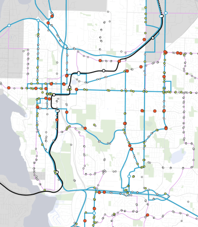
The final and largest section is “Transit Running Way,” and this one is the meat of the report. It incorporates all of the speed and reliability goodies we love, and focuses especially on corridors that are designated as frequent corridors in the Service Vision Report. Work from previous studies involving the City of Bellevue is rolled in, along with some new items developed with the Service Vision in mind. TSP, queue jumps, bus bulbs, Dexter-style boarding islands, BAT lanes, transit-only lanes, and contraflow lanes are all considered as part of a speed and reliability “toolbox” which could be applied where needs are identified. This toolbox was applied using an analysis that incorporated data from diverse sources. Then each project was prioritized using a methodology that considered its importance to the frequent network the city designed, its time savings relative to other similar projects, and previous study of the project. The result is a detailed, complete, transparent road map for how the city can most effectively use capital funds to improve speed and reliability.

The high-priority projects are all likely familiar to Bellevue transit users (and perceptive readers). The one that will be the most familiar is the “Bellevue College Connection,” a series of related projects intended to straighten and speed bus service near Bellevue College, of which the most important piece is a redesign of 142nd Ave. NE and Snoqualmie River Road to allow through bus traffic. Martin covered this project in detail, and begged for it to happen, years ago. Other high-priority projects include:
- two bus corridors in downtown Bellevue (108th Ave NE and NE 6th St)
- southbound bus lanes on Bellevue Way approaching I-90
- bus lanes on 116th Ave NE north of Overlake Hospital
- a southbound bus lane on 148th Ave NE south of SR-520
- queue jumps in three directions at the intersection of NE 8th St and 148th Ave NE, and
- signal revisions at Coal Creek Parkway and 119th Ave SE.
Regular Bellevue bus riders will recognize all of these as places where congestion regularly slows down bus service, particularly in the afternoon peak. Completion of these projects alone would help Bellevue’s transit network meaningfully.
The Bellevue Department of Transportation is to be congratulated both on the process that led to this plan and to the result. By adopting similarly clear criteria and a comprehensive approach, other local cities could bring us much closer to a future where transit trips are a realistic option for more trips, more of the time. This is how we’d like to see local transit planning work.
As a person who intentionally chose Bellevue over Kirkland and three Seattle neighborhoods when I purchased my home, I agree wholeheartedly with your comments, David. I have been consistently impressed with the Bellevue City Council. Yes, they argue and fight and posture like politicians. And yes, they spend a fair amount of time in the deep pockets of big interests (including Kemper Freeman, of course, but also big interests like Sound Transit.) But in the end, they focus on getting the facts lain out, debating them in the open, and making a decision that pleases most.
As much as we like to dismiss the suburbs on this blog, Bellevue really is trying to do the right thing. They can’t just jettison the people who lend them the image of Range Rovers and Dockers khakis that lends itself to being mocked here. But they can–and do–encourage the right kind of business development that makes Bellevue a generally great place to live. I honestly believe I get a good deal from the taxes I pay to the city. I don’t know if I’d have the same faith if I’d bought in Seattle proper.
My wife and I just chose Kirkland over several Seattle neighborhoods — we’ll be moving there next month. And I feel the same way about the leadership there. It’s responsive and usually tries to do the right thing. The truth is, though, I feel the same way about the vast majority of the Seattle leadership. Virtually all transit problems in the built-up parts of the Seattle area come down to state legislative intransigence, with a small side platter of older bureaucrats who still think “congestion reduction” is an achievable or meaningful goal.
Unfortunately, Bellevue has put itself in a very difficult position because it “just” (where “just” is a continuous process over the last 15 years or so) rebuilt much of its downtown in a way that makes walking difficult. Superblocks, 8-lane streets, narrow sidewalks, and giant parking garage entrances combine to make downtown Bellevue relatively unattractive as a walkable place. That plus lower housing prices is why we chose Kirkland. But if Bellevue keeps planning holistically for transit like it has been for the past couple of years, the trend will move in the right direction, and the redeveloped Bel-Red area may eventually become the Eastside’s next real pocket of urbanity.
I agree. Generally speaking the cities and the county do a good job. It really is the state legislature that screws up, more than anything.
“Range Rovers and Dockers khakis”
I have no idea what that means. My dad recommended Dockers when I was in college and my first jobs, as a mid level between jeans and business slacks. I’ve since worn them sometimes but not extensively. As for Range Rovers, I assume that means SUVs in general. People in Bellevue have all kinds of cars, like people in Seattle do.
I assume the author means wealthy tech folks. An unfair stereotype, to be sure. But Bellevue representatives can’t ignore that constituency, even though the area is probably more diverse (ethnically and financially) then ever.
Mike, your first sentence contains a basic truth about life, human relations, and history: nothing, and nobody lives forever- let alone, Thank God, clothing fashions and the impressions they carry. Ranger Rovers will doubtless go the way of the ’51 Hudson.
As years pass, though, it’s a shame when quality falls out from under respected brand names. Dockers used to be comfortable, appropriate for a variety of wear, and extremely well made. Meaning that one could keep a favorite personal style for many years- and save expense of constantly replacing clothes.
It’s kind of a shame about Kemper Freeman- whom I really doubt is anywhere near the presence he used to be. Whatever he added to his community, and in his position probably a fair amount, it’s likely what he’ll be remembered for was his completely unsuccessful campaign against something that would have been the benefit to him that it will now be to his successors.
For both his adversaries and allies, best memorial to the man would be to name Bellevue Central station after him, with a memorial statue in grandest 19th century tradition. Meaning no Dockers.
On their pilgrimage to the roof of Tukwila International, countless generations of pigeons will appreciate the rest stop.
Mark
“The author,” that is, I, am referring to comments made all over this blog. I won’t look up the Range Rover quotes but the “Dockers khakis and boat shoes” dig was authored by East Coast Cynic in a comment on July 1st. Basically I was referring to the general attitude of commenters on this blog towards Bellevue residents. Apparently I was a bit obscure in my reference.
Here I agree with John Bailo.
Whats been the spending per capita on bike, pedestrian, and transit improvements (over last five years?) in seattle, bellevue, redmond, and kirkland?
I have to bike or bus through Bellevue to get to work. It is miserable.
Bellevue may be putting forward planning documents to justify further planning dollars, but Bellevue is completely unserious about actually improving the anything but car transport.
And their spending shows it.
The bike lane gap on 520, and the complete lack of north/south safe options through Bellevue, and the complete lack of any east/west options…
Its fine if we’re going to praise Bellevue for pursuing more planning dollars, but it isn’t appropriate to claim that Bellevue is actually doing anything concrete for people who aren’t in cars.
I bike from downtown to Microsoft frequently and I’ll agree that there are major gaps in the bike infrastructure. 116th is a recommended street and it’s covered with potholes. But it’s not like biking in Seattle is much better. When I worked at the UW I couldn’t take the Burke-Gilman because north of the university has a street crossing every 20 yards. I opted for the I-90 route for safety, but the Arboretum isn’t exactly bike-friendly. My belief is that no city cares about bikes and pedestrians.
It seems to me that the majority of Seattle’s bike money has gone to painting sharrows–that gentle reminder that hey, there are bikes and you should respect them as vehicles. Bellevue’s money appears to have gone toward magnetic loops in the pavement to detect bikes at stoplights. I’ll take the latter any day.
But yeah, sorry, Bellevue commuting is brutal. Maybe you can find a job in West Seattle or Ballard where it isn’t so rough.
I’m praising them because this plan is much more serious than their past work (or, for that matter, than most such work you see in the region), and it’s likely to guide how future dollars will be spent. If nothing in this plan is built after 5-10 years, then I’ll criticize their funding priorities and say they’re wasting their planning efforts.
From what I read, the sharrows program was a flop. Lots of accidents and motorists complaints. Sharrows are not the answer for very heavily trafficked roads 45th Street in Wallingford.
However, they have moved on…now the design is “bicycle boulevards” where they take perhaps a parallel, but low traffic street (like 44th) and mark it for bicycles. That is certainly a better idea, although vehicular cyclists probably cringe at having to go slow through frequent intersections and circles.
In the suburbs, without lots of planning, it’s hard to do a bicycle boulevard because the side streets aren’t parallel and sometimes cul de sacs. However — it’s not impossible either! I tried making my own by piecing together a combinations of streets, alleys, and greenbelts here in Kent and found I could get a ways. Sometimes cul de sacs meet but there’s often spaces and walkways — enough for a bike.
John Bailo, I’m glad to hear that Seattle’s moved on past sharrows. They seemed ridiculously ineffective to me.
Boulevards would work well in many areas of Bellevue. I could easily imagine 110th Ave being made into a pedestrian/bicycle/transit corridor and I’ve suggested that to the council and transportation departments though I don’t expect it will happen. You could also create a boulevard inside the Spring District or along NE 8th (inside of the neighborhoods to the north) or Bellevue Way (along 100th Ave) or 156th (in the neighborhood to the east.) Cyclists will happily travel a few blocks out of the way to avoid dangerous intersections.
The best aspect of cycling in Bellevue, in my opinion, is that drivers are almost always respectful. There are many dangerous, clueless drivers but they’re usually only a problem near Microsoft.
Given the breath of the Microsoft campus…including Red West and other satellites…it’s surprising they don’t have segregated cycletracks to help avoid the main streets.
For main campus to Red West (and other locations in Redmond, like Redmond Town Center), the 520 trail serves well. On the other hand, the shuttles go everywhere. Why do you need a bike?
I have no problem with the drivers on campus–there are too many crosswalks and shuttles for drivers to be reckless. My problem is *near* Microsoft, and not just main campus. I had a motorcycle cut around me on the right when a stoplight turned green (apparently only motorized cycles need space for safety.) I was almost t-boned by a Mercedes leaving City Center. Microsoft has too many jerks in BMWs and clueless folks who just learned to drive.
On campus, I walk.
A couple of years ago Bellevue had a “Grand New Bicycle Plan” with some 90 miles of segregated cycletracks being planned for the city and environs.
Are these plans just that…plans.
Is there ever any follow up?
As someone who sat for five years on the Kent Bicycle Advisory Board, I do remember fighting and slugging to get streets and walkways redone and finally — nearly 8 years later and after I left the Board — they have been doing some very, very nice work on the street around the block from me (sidewalks!).
Still, are these plans triggered when, and if the money rolls in? What are the political or societal commitments…?
Typically, the plans help prioritize what projects get built with existing funding; support applications for regional, state, or federal grant funding; and help make the political case for more funding. “If we had funds we could build THIS bike lane next to your house” is a more compelling case for voters than “If we had funds we could build 90 unspecified miles of bike lanes… somewhere.”
I know most of you believe this to be in the realm of science-fiction, and perhaps I would include myself, but I sometimes wonder what-if we had taken all the money for LINK and all the money for DBT and instead applied it to a combination of BRT, heavy rail to the furthest reaches of the suburbs, and bicycle infrastructure.
They’re allegedly redoing the bicycle plan for 2015. The last update, in 2009, is online here: http://www.bellevuewa.gov/pedbikeplan.htm.
Franz Loewenherz, of the Transportation Department, is once again in charge of the pedestrian and bicycle plan. I have absolutely no idea if Mr. Loewenherz has every walked or biked a single block in Bellevue. I’d have to say it’s unlikely he has.
Feel free to ask him (courteously, please) about his plans. His phone is 425-452-4077 and his email is FLoewenherz@bellevuewa.gov.
It certainly is a well-organized report in its presentation. I appreciate that. I do think that it’s important to look closely at the specific projects here.
I’m curious what others think of project O-118-S/L-19, the extension of NE 6th Street over I-405. The pedestrian connection is presented as a medium priority — and the City is waiting until the entire roadway connector is built to add pedestrian connectivity (a sidewalk) to the project. Getting across the ramps on NE 4th and NE 8th is an exercise is Bellevue’s version of “fear factor” as pedestrians dash across freeway ramps. I cringe at what I see what pedestrians have to do crossing I-405 ramps today. NE 6th, when finally built, will be the same way because pedestrians will have to pass cars coming off and on the HOV ramps. Of course, the west end of this crossing is where the Downtown Bellevue Link station will be, so this is also a transit station access issue for both BTC and Link. Wouldn’t a more fast-tracked, exclusive pedestrian and bicycle connection that doesn’t require at-grade freeway ramp crossings for pedestrians make more sense? Can the East Link design over I-405 here somehow be modified to add pedestrian functionality (like Tilikum Crossing in Portland), or must pedestrians wait until the NE 6th St Extension is finally funded and built for the privilege of dashing across freeway ramp landings?
I don’t know what’s driving the timing of the parts of the 6th Street extension. All of 116th is slated for eventual redevelopment in the city’s comprehensive plan, and eventually (unlike today) there will actually be significant demand for pedestrian infrastructure in the area. It could be that the city sees the bus connection as necessary today while the pedestrian connection can wait for redevelopment.
The pedestrian crossings of the HOV ramps, once complete, should be a good deal more pleasant than today’s crossings at 8th (which is really not intended for pedestrians at all) and 4th (which has angled, super-wide GP+HOV ramps). The HOV ramps will be narrower and positioned more at right angles to the sidewalk.
There’s already a fairly dense housing population on 112th and a destination (Whole Foods) on 116th. I think if the pedestrian crossings were better (more like 10th St. or 12th St.) that more people would walk. Frankly, it’s just unpleasant to walk across 405 at 4th or 8th.
Although Whole Foods is closer to our house than the QFC, I can’t think of a time when I’ve walked to Whole Foods. I’ve walked a number of times to the QFC. And this isn’t a statement about the stores–we actually prefer Whole Foods. It’s a statement about the horribly unfriendly I-405. Don’t forget that the 116th and NE 8th intersection is the busiest in Washington State by a large margin.
I’ve walked between Whole Foods and downtown Bellevue several times, but I always take 10th St. across 405 – never 8th. Superficially, it looks out of the way, but all things considered, 10th is not only much more pleasant and safer – it’s actually faster due to having fewer stoplights to cross – even if the ultimately destination is somewhere like Bellevue Transit Center that requires backtracking south again.
Unfortunately, asdf, I live south of downtown so it really feels like a long walk to go to 10th. I’ll wait for 6th St to finish, I guess. Or maybe the train will reduce traffic in Bellevue (just kidding…)
Bellevue really needs better pedestrian and bike crossings of 405 and NE 8th. Getting across those roads is my biggest issue when traveling in Bellevue. Crossing 8th sucks east of 110th and crossing 405 varies from unpleasant (Main, 10th, 12th) to downright scary (8th, 4th).
I’d love to see Bellevue try something like what Columbus did (build bridges containing shops) at the 405 crossings. It would likely work better for Main, 10th, 12th and potential future crossings at 6th and 2nd than for 8th or 4th.
The Columbus solution wouldn’t work so well on NE 10th since there’s an interchange there.
Chris, I love the suggestion! You could work around the 10th St. interchange.
There was some talk of a lid over in downtown. It’s ridiculously expensive but I’m sure Bellevue could afford it, especially if they allowed commerce in addition to parks. Granted, the talk never made it off of STB comments: https://seattletransitblog.wpcomstaging.com/2012/03/24/a-shallower-bellevue-station/