Let’s start with an idea, a first principle if you will, that rider experience matters. Rider experience should always be our #1 goal in station and network design. Stations should be built as close to the surface as possible, with easy-to-understand way finding, built with properly sized and redundant conveyances to the platform, and station exits should be positioned to seamlessly connect to other modes. I would use a station that did all of that, wouldn’t you?
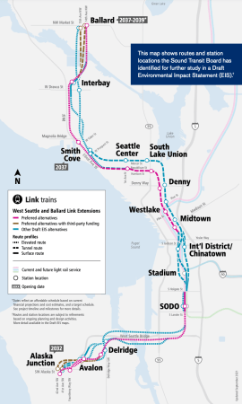
Light rail to Ballard is in trouble due in part to a $17B hole in the budget. This cost assumes a very high bridge or a very deep tunnel. Clearly the time is right to engage in some out-of-box thinking to try to find a less expensive option. What if we didn’t need a deep bore tunnel to add Ballard to the regional light rail network?
Mayor Wilson’s new proposal to install bus lanes on Denny Way is exciting and long overdue. While most discussion regarding Denny bus lanes pertains to Route 8 specifically, the potential benefit is much greater. Adding bus lanes on Denny Way would provide an opportunity to make transformative improvements to Seattle’s transit system, both for crosstown connections and South Lake Union (SLU) commuters.
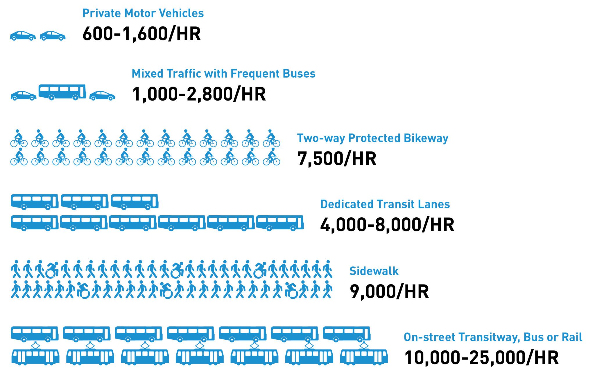
SDOT’s previous traffic studies pertaining to Denny assumed zero people (yes, zero people) would switch from driving to transit if Route 8 became more reliable. Naturally, it concluded that bus lanes on Denny would increase congestion, but it was based on a flawed assumption. Route 8 already carries about as many people as 2 of Denny’s 4 lanes despite being notoriously slow and unreliable, and Commute Seattle surveys show that travel time and reliability are among the most important factors Seattleites consider when deciding their travel mode. That being said, SDOT’s general concern regarding bus lanes leading to traffic diversion is legitimate. Bus lanes increase the capacity of a roadway (see figure below), but only if people can use them. Many drivers on Denny are going places not served by Route 8. The solution to this problem isn’t to avoid bus lanes on Denny. It’s to run more buses down Denny from more parts of the city. Doing so will improve crosstown connectivity, allow more of the city to benefit from Denny bus lanes, and get more people from cars to transit along the corridor. One way to do this would be to reroute Routes 9, 11, and 60 to Denny, which would help accomplish this goal without losing transit connectivity elsewhere in the city.
Capacity of one roadway lane, depending on its mode (SDOT)
To support the future Stride S1 line, Sound Transit recently broke ground on a new transit center (TC) in Renton. The project will relocate Renton’s primary transit center from its current downtown location to the corner of Rainier and Grady, next to the existing South Renton park and ride. The new site offers a better connection to the I-405, making it easier for the Stride S1 line to serve Renton from the freeway corridor.
The regional S1 line will run between Burien and Bellevue, with intermediate stops at Tukwila International Blvd (TIB), Renton TC, and NE 44th St. Renton TC is expected to be a major source of ridership for the line, and Sound Transit projects that it will have the second highest boardings on the S1 line, narrowly trailing TIB.
The latest idea for ST3 station placement in Downtown has the planned Midtown Station on the chopping block in favor of an expanded station at Pioneer Square where transfers between lines will be made. This is not a great idea for efficient Link transfers. But I started thinking about the possibilities of what an expanded Pioneer Square Station could be.
As luck would have it, there are other amazing transit use cases for a redeveloped King County Administration Building. Uses that mitigate a lost station at Midtown and support The One Tunnel option. Uses that would serve a dense neighborhood and large employers adjacent to the station.
Let’s start with an idea, a first principle if you will, that rider experience matters. Rider experience should always be our #1 assumption for station and network design. Stations should be built as close to the surface as possible, with easy-to-understand wayfinding, built with properly sized and redundant conveyances to the platform, allow platform-to-platform transfers in as short a distance as possible, and station exits should be positioned to seamlessly connect to other modes. I would use a station that did all of that, wouldn’t you?
With this in mind, I propose a two-station funicular train in an elevated alignment in the Jefferson Street right of way. The entire length of track is about 450 meters (~1500 ft). The downtown terminus will be in the mezzanine of a rebuilt administration building at 4rd and Jefferson, and the upper terminus at street level on the NW corner of 9th and Jefferson at Harborview. A bridge or overpass will carry the train over I-5. To get to the lower terminus from Pioneer Square Station, passageways will be cut on the east side of the mezzanines under 3rd to 4th avenue and into the new structure. There should also be additional street entrances to Pioneer Square Station on the west side of 4th and the east side of 3rd between Jefferson and James.
I wish you good fortune in reenergizing Sound Transit as you take on the CEO position. Much of the Puget Sound’s regional mobility depends on ST’s success!
When voters approved Sound Transit’s ST3 plan in 2016, they expected ST to make good use of billions of their tax dollars, and deliver sustainable and equitable transit mobility across the region over the next few decades. Much of the ST3 plan was not fully developed, so voters had to trust Sound Transit to flesh out the details. During the pandemic, we learned that transit dependent populations have the greatest needs for reliable transit, smaller numbers of workers will be returning to downtown offices, and the original plans did not consider equity. As the designs for new lines have become more detailed, cost estimates have ballooned, schedules have been delayed, and serious new challenges identified. They include how to:
make sure construction doesn’t destroy the communities Sound Transit wants to serve?
build another major tunnel through downtown Seattle, when three tunnels already exist?
make it convenient for riders to reach and transfer from other rail and bus lines?
cross major water ways while meeting the needs of the Port, the Coast Guard, the tribe and environmental laws?
serve dense neighborhoods, such as those around historic Ballard and West Seattle Junction?
prepare for branches at key points in the network to allow for future growth?
avoid generating three million tons of carbon (the equivalent of 7.5 billion gas-vehicle miles) for WSBLE at a time the region has committed to reduce carbon emissions to counter climate change?
The ST3 measure gave the Sound Transit Board broad mandate to adjust the original plan when financial, feasibility and construction challenges arise. Will you and the Board adjust the plan and develop new options to meet those challenges and increase transit ridership?
Thus far, Sound Transit has primarily focused on constructing the Tacoma-Everett-Redmond spine. As ST matures, though, priorities may need to change. Now that ridership is increasing, operational excellence and serving riders is increasingly important to be able to continue ridership growth.
If driver recruitment becomes challenging, should ST invest in automated trains and cable transit? Sound Transit’s mode selection process had been focused on the Tacoma-Everett spine. A desirable regional transit mode won’t always meet the needs of shorter urban connections like West Seattle or Ballard, where it becomes challenging to find space for large light rail stations and guideways. The ensuing cost overruns and subpar alignments are unnecessary when other modes provide far smaller footprint, better turn radii and allow for steeper gradients. Could exploring other modes also help reduce the construction related carbon emissions, minimize impact to local businesses, and loss of existing housing?
The UW Station to Capitol Hill segment is currently the busiest in ST’s light rail network, not the downtown segment. The Rainier Valley segment is almost at capacity as it runs at grade and must share intersections with road traffic. So why is a second downtown tunnel (DSTT2) a priority? Many European cities with a single downtown tunnel have upgraded their signaling to accommodate higher train frequency. Could Sound Transit do the same and use the savings to connect Ballard sooner, and allow the C.I.D. residents and businesses to recover from streetcar construction and the pandemic?
Presently, ST plans to spend $3 – $4 billion dollars to serve affluent parts of West Seattle. Could ST instead build a Duwamish bypass to increase spine capacity and grow ridership towards Seatac/Kent/Tacoma? Then ST could use urban gondola lines and buses to serve both the affluent parts of West Seattle, and the more diverse neighborhoods further South.
Many people have contributed ideas and critiques to the Seattle Transit Blog for addressing the above questions. It may be useful to review them for background knowledge on challenges ST faces going forward.
Martin Pagel
Seattle resident, STB reader, and transit advocate
This is a followup to my proposed bus restructure after RapidRide G. In that proposal, I struggled with the 12. The existing 12 overlaps the future G more than any other route; the only unique coverage area is on 19th Ave East, north of Madison.
I came up with several options for the route, each of which has its own map. As with previous maps, you can see a full size map by clicking on the corner. Once in its own window, you can select the route number on the sidebar, or the line itself to highlight the route.
The goals for each proposal remain the same. The expected frequencies are based on pre-pandemic levels, although most of these proposals would require a small increase in funding. The exception is the last proposal, which would be able to retain or increase frequency on each route, while also adding the new 106 extension.
RapidRide G will have a major impact on transit in the area, as the city implements what is arguably the first real BRT system in the state. No matter what you call it, having a bus that is both fast and frequent through the heart of the city will be a major change. It should also change the existing transit network. This is my proposal for doing that.
About the Map
As with previous maps, you can see a full size map by clicking in the corner. Once in its own window, you can select the route number on the sidebar, or the line itself to highlight the route. Care was taken to build the most realistic proposal I can muster (e. g. using existing layover locations) while trying to create an effective and efficient network. I tried to strike a balance between the existing network, and an “everywhere to everywhere” approach.
Eliminated Routes
4 — The eastern tail of the 4 is eliminated, largely because of East Link (which should occur at roughly the same time). The 4 provides direct service to downtown for riders who would otherwise have a two-seat ride. It serves other purposes (such as a one-seat ride for some trips to First or Cherry Hill) but runs infrequently. It can’t justify better service, even with one-seat riders from the Judkins Park neighborhood; it will have a tough time justifying service as those riders switch to Link. It is better to just end it, and put money into more productive routes.
11 — The 11 is replaced by the 8. Riders heading downtown from Madison Park can easily transfer to the G, Link, 10 or 12.
43 — Metro tried to get rid of the 43 back when the Capitol Hill station was added. Unfortunately, that lead to an outcry from people who were looking at an awkward transfer to go downtown (since the 11 was never very frequent). With this change, however, riders will be able to catch the 48 and then take a fast bus running every six minutes.
60 — Becomes part of the 49 (see below).
Modified Routes
2 — The 2 now serves the Pike/Pine corridor. Inbound (westbound) the bus largely takes over for the 11 (using existing stops and wire). Outbound, the bus stays on Pike longer, to avoid doglegging up to Pine, then doglegging again to cross Madison.
8 — The 8 becomes an east-west route, taking over the eastern tail of the 11.
12 — I struggled the most with the 12, and will actually suggest several alternatives in a future post. This is the default simply because it is most like the existing route. I would pair frequency with the 2 (e. g. 15 minutes on each) and synchronize the buses, to provide very good combined frequency on Pike/Pine west of Madison.
14 — The 14 is modified slightly towards its eastern tail, in conjunction with the 27. As a result, a little bit of service is added and a little bit is lost, while the main benefit is no more “out and back” travel on the 14.
27 — See 14 above.
37 — The 37 is a new coverage route to backfill service currently provided by the 8. The decision to offer service here is a close one (since riders can walk to other routes) but I think it is a good idea. By running opposite the 27, you can double up frequency along much of Yesler (an area that has been historically underserved). This provides some natural connections in the Central Area. For example it links Garfield High School with many of its students, as well as community services along Yesler.
47 — The 47 routing is the same, but I put it in this category because I want to increase its frequency (to around every 15 minutes midday). Right now it suffers from competition with the 49 (which runs a lot more often). With the 49 no longer going downtown, I expect good ridership on this route (as long as it has a decent headway).
49 — The 49 is sent to Beacon Hill instead of downtown. It takes a straight path, unlike the 60 it replaces. It would be paired with the streetcar to provide good frequency along Broadway (e. g. both could run every 12 minutes, providing 6 minute headways there). This in turn would eliminate the need for expensive express buses to First Hill (further saving service money). Combining the 60 with the 49 may result in a route that is too long. If so, the route would be split at Beacon Hill Station (with the 60 ending there, along with the 107).
106 — Provides long overdue service on Boren, connecting various neighborhoods.
Frequency
I take a somewhat optimistic view on frequency, starting with the assumption that we can return to pre-pandemic levels of service (essentially what is the “before” part of the table listed on this post). I’ve done the math, and believe that even with Metro running the G often and the new additions, we can have good frequency for this area. Most routes would run 10 to 15 minutes during the day, with only the 14, 27 and 37 running every half hour. As mentioned, the 27 and 37 would combine frequency along much of Yesler, leaving only the eastern (lower density) extremities of the region with 30 minute headways. If funding can increase, then ridership should scale along with it, without any major changes.
If funding decreases, we might have to look at cutting back some routes. I would likely eliminate the 12, as painful as that would be (and productive as that route is). The section closer to downtown overlaps existing routes, while the tail on 19th is not that far from other routes. I believe this would do the least damage to the overall network (while gaining significant savings) even though it would definitely hurt. Hopefully it won’t come to that.
In my previous post, “Notes from a Vancouverite”, I pointed out that the Sound Transit plan for Ballard and West Seattle was not very good yet had a high cost, and I advocated for a superior route to serve Ballard:
And West Seattle with a possible extension to Bellevue:
These were to be tunnelled lines using frequent, automated trains with short stations in order to save money. I note that my proposals were not taken up (although part of the West Seattle-Madison-Bellevue Line did make it into Seattle Subway’s vision), so I have decided to try again. My quest is aided by Sound Transit’s current plan, which is truly awful, and Sound Transit’s current budget, which is truly huge.
Problems with ST’s Draft EIS Plan:
1. Cost
The best I can tell the current cost estimates for the plan are over $12b:
I couldn’t find figures for the total increase in boardings that the plan will bring, but I have estimated it as follows. The DEIS estimates that the West Seattle and Ballard stations will generate 33,300 boardings per day. That includes residents of those areas starting a journey and non-residents returning from a journey started elsewhere on the transit system. So doubling that figure should give the increase in boardings due to those new stations: 66,600. In addition, the new downtown stations will generate trips among themselves and on the rest of the Link network. Because of the integration of the lines with the existing Link lines, it was difficult for me to determine which of these will be new boardings due to the additional stations or existing Link riders in DSTT 1 being moved to DSTT 2. So I’m going to be nice and say those new downtown stations will also generate 66,600 new boardings (over and above the return journeys to the West Seattle and Ballard stations already included) for a total of 133,200 boarding per day.
133,200 new boardings per day is a good expansion and justifies spending money. But over $12b? Assuming 133,200 boardings means 66,600 individual riders, you could purchase a $180,000 car for each of them with $12b. A transit line lasts longer than a car and that the real limitation for urban transportation is space and cars don’t solve that, but the metric is still not good. And it gets worse. Sound Transit’s financial plan implies that this new expansion will not cover its operating costs with fare revenue, so the actual long term financial cost is actually over $12b. And bus integration isn’t what it ought to be, so there won’t be large savings in reducing duplicating bus routes either.
Cost Benefit Analyses don’t walk on water and are based on assumptions, but it would be nice to see at least some attempt to match the total cost of the plan with the total benefit of the plan plus a comparison with other options.
2. Only One Station North of Ship Canal
Only one station north of the Ship Canal seems insane. That looks like fertile transit ground to me. Not to mention that the Ballard Station placement is only OK.
3. Terrible Stations
This is the real doozy. Some of these are so bad that there is earnest consideration on this blog about whether these plans are a pretext for cancelling the whole thing.
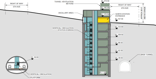
Westlake
The part in grey is the current Westlake Station, already a large structure, which demonstrates just how huge the new underground works are intended to be. If this engineering marvel did something marvellous, who would complain? But all this engineering actually just causes trouble. Making people spend five minutes or more just to get to the platform.
Since I’m actually pathetic enough to go through a bunch of this crap, I will include quite a few images of just what Sound Transit has in store for you.
Westlake Preferred Option Plan:
Westlake Preferred Option Section Facing East:
Westlake Preferred Option Section Facing West:
Westlake Preferred Option Section Facing North:
In case anyone missed it, behold Escalatorpalooza:
The Second Avenue Subway in NYC introduced the world to the concept of the billion dollar subway station. Sound Transit has not broken out the station costs separately, but I wonder, do we have a runner-up here?
Midtown
Midtown Preferred Option Plan:
Midtown Preferred Option Section Facing East:
Midtown Preferred Option Section North Stack Facing South:
Midtown Preferred Option Section South Stack Facing South:
My goal isn’t to come up with something entirely new but to adapt the current plan as much as possible to make it workable and cheaper. In the main this means a tunnelled, automatic metro with very short platform lengths:
The Stations are:
Ballard
15th Ave
Phinney
Fremont
Galer
Mercer
Denny Park
Westlake – Transfer Station
Midtown
ID – Transfer Station
Stadium (Optional) (Or Located on 1st Ave)
Delridge
Avalon – Connection to Operations Centre under West Seattle Stadium
California
I still think that Queen Anne is a worthy target for some rapid transit, but remembering the spittle flecked rage the last time I mentioned the unmentionable, I’m not pushing that one again:
The Ops Centre would be under the West Seattle Stadium which would mean ripping it up, excavating out the required area, building the ops centre and then decking it over and rebuilding the stadium and maybe the clubhouse for the West Seattle Golf Course. It is city owned so the only cost would be construction. Here is a comparison with the ops centre for Skytrain (which handles way more rolling stock):
For capacity I’m comparing this new line with the Canada Line in Vancouver. The Canada Line was built with an ultimate capacity of 15,000 passengers per direction per hour (ppdph), but is currently operated at 8,000 ppdph. Pre covid the line had a peak ridership of 150,000 boardings per day. I can tell you that 8,000 ppdph was not enough to handle that. The trains were crush loaded at peak times. So for a new 133,200 boardings-per-day line, 8,000 ppdph is probably the bare minimum.
The Canada Line uses Hyundai Rotem cars in two car trains that have a passenger capacity of 334 and a total length of 135 feet:
Operated on a 90 second interval or 40 trains per hour provides a total of 13,360 ppdph which seems like enough to me. Not enough to cover major growth in the corridor, but enough to cover some growth.
To make the central section more usable, the tunnel needs to be much closer to the surface and constructed with the cut-and-cover method. Ideally the tunnel should be as close to the surface as possible, so that the road surface is the tunnel roof. To aid in this, metro tunnels without overhead wires don’t have to be tall as light rail tunnels. 5th Avenue is not that wide downtown, but it does look wide enough to handle cut-and-cover tunnels, and it is also possible to stack the metro tunnels if need be. (Skytrain in downtown Vancouver is stacked.)
However, one disadvantage must be acknowledged. Shallow tunnels will make a total mess of the current Westlake Station. The tunnels will have to go through the current mezzanine and require a bunch of reconstruction:
On the other hand, short platforms really expose the gigantism that has overtaken Sound Transit’s plan. Here are several images of the Sound Transit plan with a shallow 150 foot station box superimposed.
Midtown:
Midtown:
ID:
ID – Shallow tunnels under 5th:
Westlake:
One concern with cut-and-cover construction is the amount of time that the road will be closed. However, in this case, this is almost a benefit. Some of the stations in the current plan are so big and complicated that the construction timeline anticipates that they will be under construction for 9 years! And there is no reason why cut-and-cover cannot be done quickly. The Pine Street cut-and-cover segment of the original DSTT was built in under six months albeit with a temporary surface put down for the Christmas shopping season that had to be taken up and re-done in the slower shopping months.
The tunnels will have to be bored south of ID and north of Denny Park, but even then, the very short station boxes make things so much easier. Here is a 150’ station box at 15th Ave:
This is less than a third of the block.
Costs
This is my estimate of costs in millions:
Tunnel at 150m per km
2,475
14 Stations at 150m each
2,100
Westlake Mess
250
Operations Base
500
Sub-Total
5,325
Seattle Nonsense
1,000
More Seattle Nonsense
1,000
Total
7,325
The 150m per km figure is from Alon Levy who estimates that this is the no-BS international cost of metro lines (I think he also means to include stations and rolling stock too but I daren’t go that far). Stations I have pencilled in at 150m each which is on the high side plus an additional 250m for a total of 400m at Westlake because it will be a mess. And the operation centre at 500m is also on the high side but it means that it can be done right.
For those that think that my estimates are unreasonably low, actually 5.325b for a short metro line is no bargain and 7.325b is properly expensive. (Sound Transit first estimated this extension at 7b for ST3.) There are those on this blog that decry tunnelling at the main driver of costs, but it isn’t tunnels, its stations. Colossal, overblown stations mean colossal, overblown costs. The tunnel from downtown to Roosevelt was expensive but not preposterous, so it can be done, even in Seattle. And the promise of lower costs above ground is clearly spent. Elevated lines can be built cheaply on publicly owned ROWs, but it isn’t that cheap on purchased land, and not if there are two bridges and a high level viaduct as in West Seattle.
As a postscript, this is how I would outline expansion if that were undertaken. Two interlined lines going east and west. Since the peak frequency is 90 seconds, interlining only drops this to 3 minutes which is still perfectly doable if expansion were desired in the future.
Frequent commenter RossB recently posted a link to the paper, The Impact of Zoning on Housing Affordability. The title is somewhat of a misdirect because in the opening paragraph it says:
This paper argues that in much of America the price of housing is quite close to the marginal, physical costs of new construction.
The Introduction goes on at some length to emphasis that it is about the cost of housing and not meant to address the issue of poverty. This is key to recognize because it separates the homeless issue from the affordability of housing. As it states on page 4, “To us, a housing affordability crisis means that housing is expensive relative to its fundamental costs of production, not that people are poor.” This is a key concept when related to supply and demand. People who aren’t in the market for a home by definition are not part of demand as it relates to economics. They may want a house, they may need a place to live, but they are not influencing the market price of homes. Or, as they say in the paper, “Hence, we focus on the gap between housing costs and construction costs.”
The publishing of the Central Tacoma Link Extension (CTLE) proposal within this blog has stirred a large debate regarding how Link should properly serve the City of Tacoma over a decade from now. There was broad agreement that terminating services at Tacoma Dome Station was deeply unsatisfactory, with most commenters agreeing that a natural terminus for the regional metro system is, indeed, Downtown Tacoma.
However, among the many proponents of such an extension, there were legitimate concerns of how it would be accomplished. Where CTLE came under routine fire was on two fronts: its interaction with the existing streetcar system, and the location of the Central Tacoma Station. Although these points are addressed extensively on these pages and on other websites, they are real concerns that warrant further investigation. The CTLE surface option remains the cheapest and most cost effective manner of delivering trains into Central Tacoma. That station, even without extensive bus connections, has independent utility as a rail station in an urban core. Still, it is worthy to consider alternative alignments into Tacoma that: one, have no impacts on the existing streetcar system; two, more finely integrate Link with the existing Downtown transit corridor along Commerce Street, and; three, furthers the conversation of getting trains into the city center.


