Notes from a Vancouverite, Revisited

In my previous post, “Notes from a Vancouverite”, I pointed out that the Sound Transit plan for Ballard and West Seattle was not very good yet had a high cost, and I advocated for a superior route to serve Ballard:

And West Seattle with a possible extension to Bellevue:

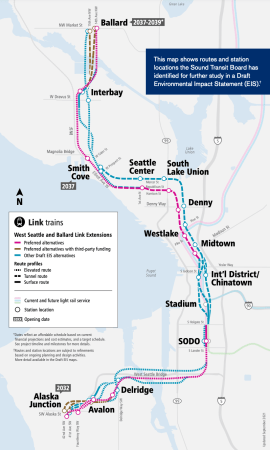
These were to be tunnelled lines using frequent, automated trains with short stations in order to save money. I note that my proposals were not taken up (although part of the West Seattle-Madison-Bellevue Line did make it into Seattle Subway’s vision), so I have decided to try again. My quest is aided by Sound Transit’s current plan, which is truly awful, and Sound Transit’s current budget, which is truly huge.

Problems with ST’s Draft EIS Plan:

1. Cost

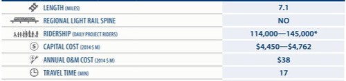
The best I can tell the current cost estimates for the plan are over $12b:

I couldn’t find figures for the total increase in boardings that the plan will bring, but I have estimated it as follows. The DEIS estimates that the West Seattle and Ballard stations will generate 33,300 boardings per day. That includes residents of those areas starting a journey and non-residents returning from a journey started elsewhere on the transit system. So doubling that figure should give the increase in boardings due to those new stations: 66,600. In addition, the new downtown stations will generate trips among themselves and on the rest of the Link network. Because of the integration of the lines with the existing Link lines, it was difficult for me to determine which of these will be new boardings due to the additional stations or existing Link riders in DSTT 1 being moved to DSTT 2. So I’m going to be nice and say those new downtown stations will also generate 66,600 new boardings (over and above the return journeys to the West Seattle and Ballard stations already included) for a total of 133,200 boarding per day.

133,200 new boardings per day is a good expansion and justifies spending money. But over $12b? Assuming 133,200 boardings means 66,600 individual riders, you could purchase a $180,000 car for each of them with $12b. A transit line lasts longer than a car and that the real limitation for urban transportation is space and cars don’t solve that, but the metric is still not good. And it gets worse. Sound Transit’s financial plan implies that this new expansion will not cover its operating costs with fare revenue, so the actual long term financial cost is actually over $12b. And bus integration isn’t what it ought to be, so there won’t be large savings in reducing duplicating bus routes either.

Cost Benefit Analyses don’t walk on water and are based on assumptions, but it would be nice to see at least some attempt to match the total cost of the plan with the total benefit of the plan plus a comparison with other options.

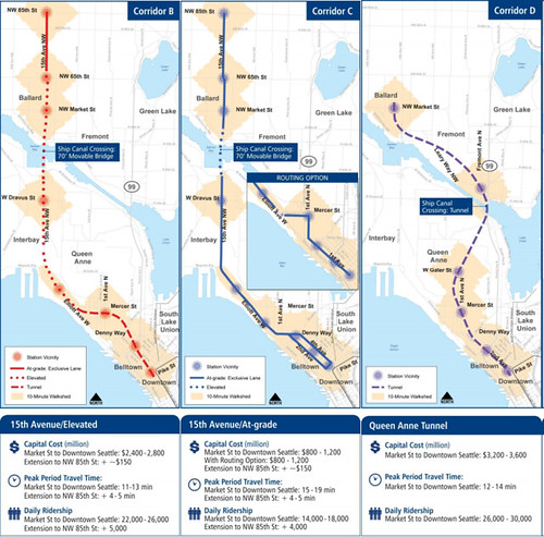
2. Only One Station North of Ship Canal

Only one station north of the Ship Canal seems insane. That looks like fertile transit ground to me. Not to mention that the Ballard Station placement is only OK.

3. Terrible Stations

This is the real doozy. Some of these are so bad that there is earnest consideration on this blog about whether these plans are a pretext for cancelling the whole thing.
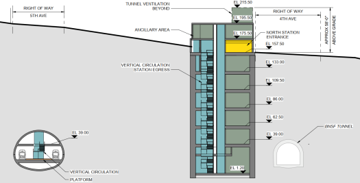
Westlake

The part in grey is the current Westlake Station, already a large structure, which demonstrates just how huge the new underground works are intended to be. If this engineering marvel did something marvellous, who would complain? But all this engineering actually just causes trouble. Making people spend five minutes or more just to get to the platform.

Since I’m actually pathetic enough to go through a bunch of this crap, I will include quite a few images of just what Sound Transit has in store for you.

Westlake Preferred Option Plan:

Westlake Preferred Option Section Facing East:

Westlake Preferred Option Section Facing West:

Westlake Preferred Option Section Facing North:

In case anyone missed it, behold Escalatorpalooza:

The Second Avenue Subway in NYC introduced the world to the concept of the billion dollar subway station. Sound Transit has not broken out the station costs separately, but I wonder, do we have a runner-up here?

Midtown

Midtown Preferred Option Plan:

Midtown Preferred Option Section Facing East:

Midtown Preferred Option Section North Stack Facing South:

Midtown Preferred Option Section South Stack Facing South:

Midtown Preferred Option Ventilation Section Facing South:

New Vancouverite Plan

My goal isn’t to come up with something entirely new but to adapt the current plan as much as possible to make it workable and cheaper. In the main this means a tunnelled, automatic metro with very short platform lengths:

The Stations are:

  • Ballard
  • 15th Ave
  • Phinney
  • Fremont
  • Galer
  • Mercer
  • Denny Park
  • Westlake – Transfer Station
  • Midtown
  • ID – Transfer Station
  • Stadium (Optional) (Or Located on 1st Ave)
  • Delridge
  • Avalon – Connection to Operations Centre under West Seattle Stadium
  • California

I still think that Queen Anne is a worthy target for some rapid transit, but remembering the spittle flecked rage the last time I mentioned the unmentionable, I’m not pushing that one again:

The Ops Centre would be under the West Seattle Stadium which would mean ripping it up, excavating out the required area, building the ops centre and then decking it over and rebuilding the stadium and maybe the clubhouse for the West Seattle Golf Course. It is city owned so the only cost would be construction. Here is a comparison with the ops centre for Skytrain (which handles way more rolling stock):

For capacity I’m comparing this new line with the Canada Line in Vancouver. The Canada Line was built with an ultimate capacity of 15,000 passengers per direction per hour (ppdph), but is currently operated at 8,000 ppdph. Pre covid the line had a peak ridership of 150,000 boardings per day. I can tell you that 8,000 ppdph was not enough to handle that. The trains were crush loaded at peak times. So for a new 133,200 boardings-per-day line, 8,000 ppdph is probably the bare minimum.

The Canada Line uses Hyundai Rotem cars in two car trains that have a passenger capacity of 334 and a total length of 135 feet:

Operated on a 90 second interval or 40 trains per hour provides a total of 13,360 ppdph which seems like enough to me. Not enough to cover major growth in the corridor, but enough to cover some growth.

To make the central section more usable, the tunnel needs to be much closer to the surface and constructed with the cut-and-cover method. Ideally the tunnel should be as close to the surface as possible, so that the road surface is the tunnel roof. To aid in this, metro tunnels without overhead wires don’t have to be tall as light rail tunnels. 5th Avenue is not that wide downtown, but it does look wide enough to handle cut-and-cover tunnels, and it is also possible to stack the metro tunnels if need be. (Skytrain in downtown Vancouver is stacked.)

However, one disadvantage must be acknowledged. Shallow tunnels will make a total mess of the current Westlake Station. The tunnels will have to go through the current mezzanine and require a bunch of reconstruction:

On the other hand, short platforms really expose the gigantism that has overtaken Sound Transit’s plan. Here are several images of the Sound Transit plan with a shallow 150 foot station box superimposed.

Midtown:

Midtown:

ID:

ID – Shallow tunnels under 5th:

Westlake:

One concern with cut-and-cover construction is the amount of time that the road will be closed. However, in this case, this is almost a benefit. Some of the stations in the current plan are so big and complicated that the construction timeline anticipates that they will be under construction for 9 years! And there is no reason why cut-and-cover cannot be done quickly. The Pine Street cut-and-cover segment of the original DSTT was built in under six months albeit with a temporary surface put down for the Christmas shopping season that had to be taken up and re-done in the slower shopping months.

The tunnels will have to be bored south of ID and north of Denny Park, but even then, the very short station boxes make things so much easier. Here is a 150’ station box at 15th Ave:

This is less than a third of the block.

Costs

This is my estimate of costs in millions:

Tunnel at 150m per km2,475
14 Stations at 150m each2,100
Westlake Mess250
Operations Base500
Sub-Total5,325
Seattle Nonsense1,000
More Seattle Nonsense1,000
Total7,325

The 150m per km figure is from Alon Levy who estimates that this is the no-BS international cost of metro lines (I think he also means to include stations and rolling stock too but I daren’t go that far). Stations I have pencilled in at 150m each which is on the high side plus an additional 250m for a total of 400m at Westlake because it will be a mess. And the operation centre at 500m is also on the high side but it means that it can be done right.

For those that think that my estimates are unreasonably low, actually 5.325b for a short metro line is no bargain and 7.325b is properly expensive. (Sound Transit first estimated this extension at 7b for ST3.) There are those on this blog that decry tunnelling at the main driver of costs, but it isn’t tunnels, its stations. Colossal, overblown stations mean colossal, overblown costs. The tunnel from downtown to Roosevelt was expensive but not preposterous, so it can be done, even in Seattle. And the promise of lower costs above ground is clearly spent. Elevated lines can be built cheaply on publicly owned ROWs, but it isn’t that cheap on purchased land, and not if there are two bridges and a high level viaduct as in West Seattle.

As a postscript, this is how I would outline expansion if that were undertaken. Two interlined lines going east and west. Since the peak frequency is 90 seconds, interlining only drops this to 3 minutes which is still perfectly doable if expansion were desired in the future.

Notes on Queen Anne

I am posting this density map as an adjust to my previous post “Notes from a Vancouverite” as an explanation of my stop on Queen Anne.

Seattle Population Densityre

Taking into account the caveat that not all the darker area is in fact up the hill and also that the density variation within one colour is large, I still note that Queen Anne isn’t nothing.

Notes from a Vancouverite

My purpose here is to put a few ideas in front of Seattleites that I think might be useful in the debate about transit expansion. Obviously I live in Vancouver, but, as folks here have noted, Vancouver does have useful transit lessons to other cities in the region.

1. West Seattle

The current plan is Option 1:

image001 West Seattle Options

Instead of running parallel to the current Link line, my proposal is for a line that crosses the current line and continues into the central district:

image002 West Seattle Proposal

Double dots indicate stations and single dots are just to show the route. The line needs to curve against the harbour headland to stay within shallow water. The stations would probably need to be deep, so it would go under the existing Link line and the existing train line. Because the station under Broadway would be the deepest, there would be a possibility of a level entrance at Boren that would access the platform more or less horizontally with a moving walkway. Expensive, yes, but far cheaper than a whole separate Boren station.

This line is cuts the distance from Alaska Junction to downtown from 9.5km to around 8km, and obviously the distance from North Admiral is shorter still.

Length of current plan:

image003 ST3 West Seattle Route Distance

Length of proposal:

image004 West Seattle Proposal Route Distance

Obviously the actual station locations could be adjusted to meet the connection requirements to the current Link line:

image005 West Seattle Route Station Options

I’m also not sure whether continuing the line down Madison is the right thing to do or rather have it continue due east on Union might make better sense for bus connections.

The stations south of Admiral could be built later, but in any case, a BRT or BRT lite system would have to be implemented on California to get the maximum benefit of such a line.

The line could also be extended further south to serve more areas and improve bus connections. This diagram is penciled out to White Center, but Burien might also be a logical termination point:

image006 West Seattle Extension Options South

The principal improvements over the current proposal are:

  • The line serves the central district.
  • The line makes for a very fast trip from the north part of West Seattle to downtown and the central district. Quick trips make for good ridership.
  • The line requires no interlining, so it could run at full two minute frequency which is beneficial for a bus transfer system. And it also would not burden the existing Link line.
  • The line is separate from the rest of the system so it could be automated. The natural location for the operation centre would be under the Hiawatha playing field at the park in North Admiral. Playing fields don’t need deep soil like trees, so they could easily be accommodated over the deck of an underground op centre which also does not need to be that big as there would not be very many trains and they would be short two or three car units.
  • The line would eliminate the need for the Madison BRT and finally serve First Hill properly.
  • The line need not be heinously expensive. What I have penciled out matches the Canada Line in Vancouver which was $120m CAD per km. Double it for Seattle prices, and that is $180m USD per km or $1.85b from Alaska Junction to Madison and 23rd.

Principal drawbacks are:

  • Requires transfer to other parts of Link.
  • Possible worse bus transfer from buses on Delridge. Might mean needing to build further south than Alaska Junction even on initial segment.

A possible extension, but very fanciful at this point, would be to extend such a line to Bellevue with a tunnel under Lake Washington or a new floating bridge for trains and bikes:

image007 West Seattle Extension Options East

Built as a buried fully grade-separated metro, such a line would offer very fast service between Bellevue and Seattle downtowns which would be as transformative as the UW Capitol Hill Link extension. And a frequent automatic line would enhance the operation of bus transfers off Bellevue Way and I-405. An absolutely vast improvement over the current East Link plan.

To serve the central district Seattle Subway and commenters on this blog have pushed for a metro 8 subway as in yellow below:

image008 Seattle Subway Plan

I am skeptical about this line. Such a line would be perfectly useful, but it also would be basically the same distance as my Junction to Madison line and thus the same cost. And while serving SLU is laudable, there is still more employment in the traditional downtown and thus more demand there than to SLU.

There are also other solutions to ease connections to SLU. I think that a bike and moving walkway tunnel from Capitol Hill to SLU might be just the ticket. The tunnel would have a level entrance down the hill and elevator access up the hill:

image009 Capitol Hill SLU Connector

Other commenters on this blog have pushed for another DSTT to serve a network of West Seattle buses to avoid transfers and to better serve the more diffuse population in West Seattle.

New WSTT:

image010 WSTT Plan

Or, more efficiently, a new DSTT and turn current DSTT into a bus tunnel again:

image011 Second DSTT Plan

I am also skeptical about this idea. First, because bus stations need to be so much larger to allow for long platforms and passing, building a bus tunnel is more expensive than building a rail tunnel. If you were to do such a thing, it really would make more sense to build another train tunnel through downtown, move the current link line to the new tunnel and then use the existing DSTT for buses again. Second, by having so many buses continue to go downtown, the bus service within West Seattle is not necessarily optimized, eg the natural bus corridor up and down the entire length of California. And third and most importantly, having bus to rail transfers before heading downtown is so much more operationally efficient than continuing with so many buses heading downtown.

2. Ballard

My proposal is not a new idea, but a critique and revision of the current plan based on optimizing the bus connections of a new line. This is the current plan:

image012 Ballard Route

image013 Ballard Route Option 2

image014 Ballard Route Option 1

This plan has some serious weaknesses:

  • Huge cost
  • Misses Queen Anne and Belltown
  • Only one bus connection point north of the canal.
  • Moveable bridge
  • Peak headway of 6 minutes
  • So-So ridership with 60,000 to 74,000 riders using the system north of Westlake

My proposal is to reconfigure this line as a bus collector with four stops north of the canal such that any sensible person going to Belltown or Downtown would transfer to the rail line. As a bonus, these four stations also have decent walksheds:

image015 Ballard Route Proposal

Such a line would naturally be fully grade separated and automated with two minute headways.

The connection off Aurora will have to be somewhat trippy with bus stops on the bridge deck and elevator or escalator access down to the Fremont station underground, probably involving rebuilding some of the buildings adjacent to the bridge deck, but such a connection would be a good one.

Some route options like this proposal was investigated by Sound Transit, but those options were not optimized to encourage bus connections. Even with the lack of optimization, the ridership estimates were unreasonably low. This table from the Ballard Options Study of May 2014 have very low ridership estimates for all of the options studied:

image016 Ballard Route Options

The low ridership estimates for Corridor D were ammunition for criticism of this option on the STB, but the low estimates of all the options shows that bus connections were not optimized or even really considered for any of the corridors. The Ballard Line Comparison Chart of December 2015 had greatly increased estimates for all the options that survived the first round:

image017 Ballard Route Option etc

I could not find a reason why these estimates went up so much, but they do imply that an all tunnelled option a la Corridor D would have the highest ridership of all.

The current plan skips Belltown in favour of SLU, and it is possible that such a route might have higher ridership, but I haven’t chosen this because it isn’t obvious to me that, fully built out, SLU will have higher employment+residential+commercial density than Belltown. Additionally, SLU does have a streetcar connection to Westlake that can be improved.

The principal improvements over the current proposal are:

  • Line and stations location is optimized to serve connecting bus passengers on all of the north south avenues west of Green Lake. The current plan does nothing for people in Fremont, Greenwood, Phinney Ridge or the Aurora corridor. And a bus optimized metro system will also mutually reinforce the bus service justifying increased frequency and full BRT on Aurora and BRT lite on some of 24th, 15th, 8th and/or Greenwood.
  • In addition to being an effective bus collector system, the line has useful urban stations that allow it to act like a traditional metro. The current proposal just does not have as many of these. Clubbers in Belltown, cyclists to Fremont and the Burke-Gilman, walkers to Woodland Park and weekend brunchers to Old Ballard all get something useful.
  • The line serves Queen Anne which really ought to have quick service considering its central location.
  • Avoids any moveable bridges and has much better frequency. With trains every two minutes, the system could be split and extended up one of the north south avenues at some point while still maintaining four minute service in each branch.
  • Likely far better ridership.

Principal drawbacks are:

  • Skips Interbay and SLU. I’ve explained Belltown over SLU, and for similar reasons Queen Anne and Freemont are more suitable destinations than Interbay.

On this blog there is big support for a Ballard to UW connection over Ballard to Downtown connection as shown here in comparison with my proposal:

image018 Ballard Route Comparison

I would not support a UW connection before a downtown connection. First, there is more demand to downtown from both Ballard and Fremont than to UW so it makes sense to serve that demand directly:

image019 Ballard Transit Demand

Second, if the UW line is interlined with Northgate, the frequency suffers which harms the desirability of bus transfers to the UW line, but if the UW line is not interlined with Northgate, it adds a transfer which also harms the desirability of bus transfers to the UW line. In short, such a line would not be an optimized bus transfer system.

One thing that I have left out is the second downtown tunnel and connection to the maintenance area. Ideally when the DSTT was converted to rail, the possibility of fast interlining ought to have been built in, but it wasn’t, and such ST is committed to a second parallel downtown transit tunnel. If combined with my West Seattle proposal, stations at Westlake, 5th and Madison and Yesler would make sense. Through SODO to the maintenance centre, whether that was located at the current facility, the line would have to be elevated.

One fanciful thought experiment, as if blog-posted transit fantasies were not fanciful enough, would be to use this line as the Rainier Valley bypass line and extend this to link to Link at Seatac at full two minute frequency:

image020 Ballard Route Extension Options

Since there does not seem to be any streetrunning planned for Link from Angle Lake to Tacoma, this could use the automated, short train, high frequency model that is better for transfers.

The Rainier Valley link could then be redirected toward Renton at which is an odd lacuna in ST1 to 3.

I welcome your suggestions.

yvrlutyens

March 29, 2017