
NYC Subway Maps

This post originally appeared on Orphan Road.

Matt Yglesias points to two altnerative takes on the NYC subway map, which you can find here and here. The first — used by the MTA until 1972 — sacrifices geographical consistency for cleanness of lines, and so makes for a very useful subway map but doesn’t map to the real world above ground very well. The second is a nicer hybrid of the current version and the more abstracted original.

It goes to show that maps are very context dependent: you reall have to think about what your overall goals are for disseminating the information. If you want people to be able to find their way once they get out of the subway station — or get a sense of how far they have to walk once they emerge — that puts different constraints on the design.
Ride the Obama Train

This post originally appeared on Orphan Road.

For hard-core rail advocates, there was never a better candidate in the 2008 presidential race than Bill Richardson, who not only talked the talk as a presidential candidate, but also walked the walk by launching a passenger rail service in Albuquerque when he was governor of New Mexico.

But now that Richardson’s gone, we rail junkies will have to get our fix from Barack Obama, who’s the only candidate left who’s still interested in rail transit as a way to reduce our dependence on oil.

(via)

Pt. Townsend Passenger Ferry

This post originally appeared on Orphan Road.

The Pt. Townsent chamber has a fever*, and the only cure is more passenger ferry:

The $100,000 the chamber is willing to chip in was initially earmarked to help fund passenger-only ferry service during the Hood Canal Bridge closure, scheduled for spring 2009. Caldwell, however, said the service could start much earlier and become permanent if a private boat operator can forge agreements with local merchants and if the city or the state is willing to match the chamber’s contribution.

Companies that might be interested in operating the service include Port Townsend’s Puget Sound Express and Clipper Navigation, the company that operates the high-speed Victoria Clipper between Seattle and Vancouver Island.

“We can start this service long before the bridge closes,” Caldwell said. “There is a boat available now.”

*See here if you don’t get the reference.

Nearby Supermarkets?

I just read this incredibly depressing article in the PI about the neighborhoods in Seattle where carless people cannot find groceries without serious effort. The story chronicles a 55-year-old Delridge resident who needs a bus and some serious walking to get groceries. I’ve always lived pretty near to at least one supermarket (I have one two blocks away now), but where my mother lives, off Greenlake, the nearest supermarkets are several miles away.

What neighborhoods are lacking nearby supermarkets? Obviously the Meridian/Tangletown neighborhood, and I know most of Downtown is missing supermarkets, though one store is coming to the Financial District and a Trader Joe’s supposedly is coming to a Belltown/Denny Triangle development in a few years, though I can’t comfirm this. I also can imagine that most far-off neighborhoods in the far north and south are missing supermarkets. I’d love to live in a city where no matter where you lived, it’d be easy to walk to get necessities. Can you walk to a grocery store from your house?

TOD and BART

This post originally appeared on Orphan Road.

When you’re building a new BART station from the ground up, you might as well build transit-oriented development around it, affordable housing and all:

Housing on both sides of the station will be located within a quarter mile — or 10-minute walk — of Safeway, Target and Stoneridge mall. The developer may also consider establishing a Flexcar program on-site, to allow residents to rent vehicles.

The two-story BART station building will be constructed in the I-580 median and will connect via pedestrian bridges over the freeway to the mixed use projects in Pleasanton and Dublin.

Four-story parking garages for BART patrons will also be constructed on each of the Pleasanton and Dublin station-area properties.

Garages, eh? Shh…don’t tell the Sierra Club!

I kid. Seriously, though, this sounds pretty cool. Too many BART stations are surrounded by freeways and parking lots and other trappings of suburbia. Nice to see that they can adapt.

Dulles Rail

This post originally appeared on Orphan Road.

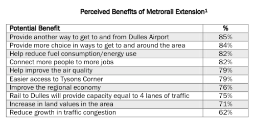
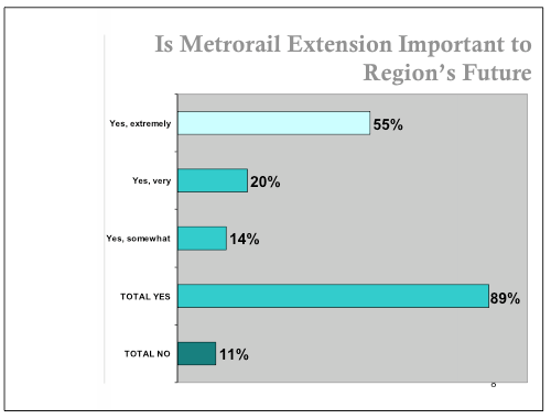
Some very encouraging findings (.pdf) from a survey of DC-area residents on expanding Metro to Dulles Airport. 93% of Northern Virginians support it. And check out some of the details:

Picture 1.png

Picture 2.png

You can’t get that kind of consensus in Seattle on the weather, let alone a transit project.

(via)

Revitalization

This post originally appeared on Orphan Road.

What’s interesting about the article linked below is that it was written before the revitalization of America’s downtowns and the drop in urban crime in places like New York. From the standpoint of the late 1980s — Times Square had yet to be Disney-ified, Baltimore’s retro-downtown ballpark at Camden Yards hadn’t opened yet — things must have looked pretty bleak from the urban planner’s point of view (Joel Garreau’s Edge City came out in 1992).

All of which is to say that I think things are actually better right now. We’ve learned a lot in the past 20 years about the problems with sprawl — traffic, environmental stress, global warming, oil wars — and were slowly adjusting livnig and working patterns to adapt.