
In 2023, Link Light Rail’s Red Line will travel from Lynnwood to either Highline College or Federal Way Transit Center, depending on funding. Lots of digital ink has been spilled about things like long endpoint travel times, armchair quarterbacking the time savings that might be achieved from buses leaving the tunnel, with no real clarity on the answers. In addition, we usually look at Link in fragments, with the nomenclature of “Central Link”, “U-Link”, “North Link”, “the Spine” etc far more common than the Red Line and the Blue Line. But no one in Portland still refers to the Blue Line as “Eastside MAX” and “Westside MAX”, and come 2023, the wonkier segment names will give way to simple color.
So I thought I’d take a look at the nascent Red Line in its entirety. Where will it take you? In how long? If you were to rent or buy a home to maximize the value of Link’s frequency and reliability to your life – if in Jarrett Walker’s phrase, you wanted to be on the way – where should you live? Where is Link’s ‘center of gravity’, the place along the line where the most places are accessible most quickly?
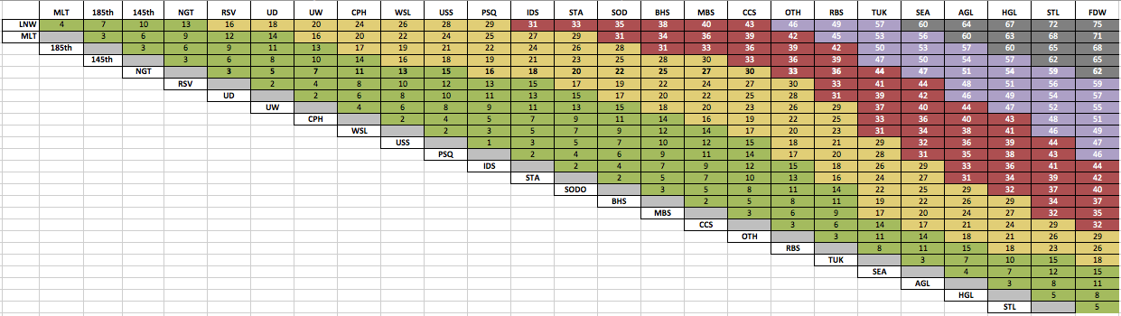
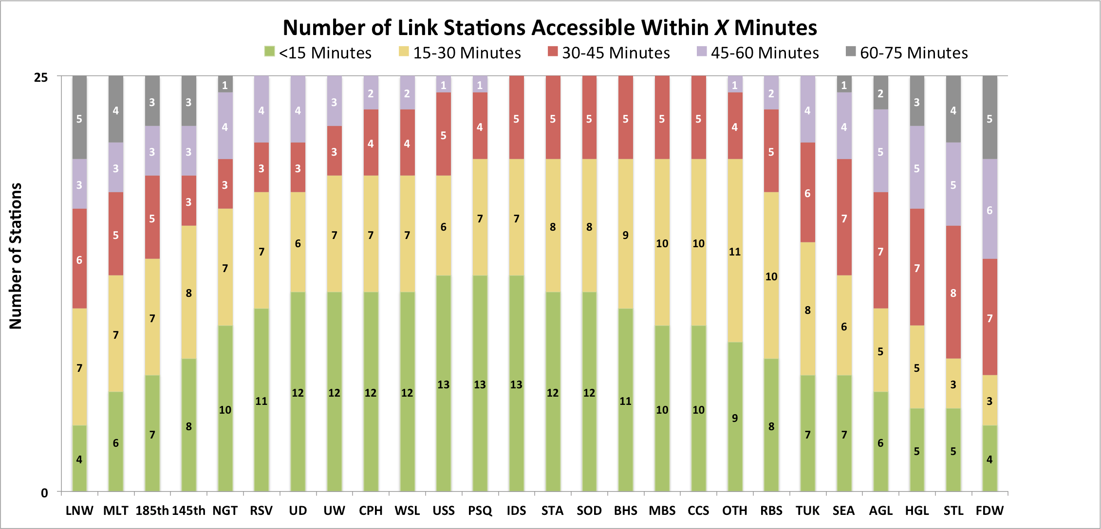
I asked Sound Transit’s Bruce Gray for travel times between all stations for the full ST2 buildout, and I’ve reproduced those with modification below (also adding Star Lake (STL) and Federal Way (FDW)). I then split the travel times into 5 tiers to show where you can travel from any given station in 0-15 minutes (green), 15-30 minutes (yellow), 30-45 minutes (red), 45-60 (purple), and 60-75 minutes (gray). While the first chart is most useful for seeing the relationship between individual stations, the second chart below presents the same data in a way that is most useful for relating an individual station to the Red Line as a whole.

Abbreviations in the chart are Lynnwood (LNW), Mountlake Terrace (MLT), Northgate (NGT), Roosevelt (RSV), UDistrict (UD), Capitol Hill (CPH), Westlake (WSL), University Street (USS), Pioneer Square (PSQ), International District (IDS), Stadium (STA), Sodo (SOD), Beacon Hill (BHS), Mount Baker (MBS), Columbia City (CCS), Othello (OTH), Rainier Beach (RBS), Tukwila International Boulevard (TUK), SeaTac Airport (SEA), Angle Lake (AGL, Highline College (HGL), Star Lake (STL), and Federal Way (FDW).
Observations below the jump.
Observations:
1. A rail-only tunnel saves 5 minutes per run. UW to Westlake travel times improve from 8 to 6 minutes, and Westlake-SeaTac times improve from 37 minutes to 34. A trip from UW to SeaTac in 2016 will take 45 minutes, while in 2023 those same 45 minutes would get you from UW to just short of Highline.
2. If you care most about having lots of fast trips to the most places, unsurprisingly you should live Downtown. University Street, Pioneer Square, and International District Station (IDS) have 13 stations within a 15-minute ride. A Pioneer Square resident could travel anywhere from Roosevelt to Columbia City in 15 minutes.
3. If the outer stations are valuable to you and you value accessing the entirety of the line with the least travel time, you should (somewhat surprisingly) live in Southeast Seattle. The 6 stations from IDS to Columbia City are the only segment of the entire line where you could travel to either end in less than 45 minutes.
4. If you want or need to live in the suburbs but want easier access to the central city, Snohomish County is a better bet, with far more urban stations within 30 minutes compared to South King County. 26 minutes gets a Lynnwood resident to Westlake, a 17 minute improvement on today’s peak-of-peak Route 511 despite stopping 8 times on the way. By contrast, those same 26 minutes get a Federal Way rider only to Rainier Beach.
What do you see? What patterns are interesting to you?
This is Part 1 of a 3-part series. In Part 2, we’ll take a similar look at the Blue Line (Lynnwood-Overlake). In Part 3, we’ll compare Red Line and Blue Line travel times to their bus alternatives for all station pairs.
[Eds, The original version of this story transposed the Red and Blue Lines, this has been corrected in the text. We regret the error.]
Ever see those maps of the world that have continents resized by population?
It would be interesting to see how this would look over the entire network, including bus connections.
For example, obviously someone living near the Beacon Hill station has experienced an effective reduction in time from there to the UW. However, getting from there to Fremont or Ballard is not changed much.
Due to those network effects you wind up with effectively making SLU somewhat more isolated from Downtown – UW due to the travel time improvements between downtown and UW.
A comprehensive chart like the one shown for various neighborhoods throughout Seattle would be fascinating. It would require a lot of work, and since bus routes change, it would be tricky. But if you simply looked at bus routes following the proposed restructure, I think it could be done. I would make the following assumptions:
1) Transfers take a couple minutes.
2) Add half the average frequency of each trip. This basically is how long it will typically take if you don’t try and time things.
If you do that, then you can pick various neighborhoods and see whether things have changed, and if so, by how much. Personally, I would focus on Seattle, and get granular when it comes to the neighborhoods. So, for example, I would include Garfield High School and 23rd and Yesler, even though they are both part of the C. D. They are remarkably different from a transit perspective. The same is true throughout the city. A neighborhood like Ravenna, for example is fairly small, but riders have a choice to make when it comes to getting to the UW. If you are close to 65th, and the bus along 65th runs quite often, then a connection to Link makes sense. Otherwise, just heading south (on 25th) is a lot easier.
So obviously building such a chart could get really complicated. But even just a basic one would show how convenient it is is to get from one place to another. Such a chart, for example, would show how important a NE 130th station is. You would have to make certain assumptions about bus service, but even having done that, it would be a substantial improvement for a lot of trips.
I would love to see made (or make for myself) the 45 minute ‘freedom’ map that Jarrett Walker discusses – from a starting point, map where you can go by transit (or even transit + walking) in 45 minutes, before and after Link and the Metro restructure.
From what I understand, the “Red Line” will go all the way to Lynnwood all-day long now. It will not stop at Northgate.
Yes, because we clearly need just as much capacity from Lynnwood to Northgate as we need from the U-District to downtown.
I’m not the one who made that decision [ah]. I’m just telling you what my understanding is of how it will operate.
I assume you mean not *end* at Northgate.
ST originally had East Link going to Lynnwood only peak hours. It later extended all runs to Lynnwood believing the capacity would be needed. Nobody believes Lynnwood will be as full as U-District to downtown, but ST’s numbers show that at least Shoreline will need more capacity than six 4-car trains per hour, if not right in 2023 then by 2030.
That’s a total of 24 cars per hour. Four of those represent the current 512, which has gotten standing-room only and will need more runs in the near future. That leaves 20 cars remaining. I’ll leave it to the reader to guess who will be in those cars and how many of them will be empty.
The biggest issue is there’s pent-up demand for transit between Snohomish County and north Seattle, which is practically unusable now. Many people live in Snoho and work around Northgate, 85th, Sand Point, etc, and there’s no express bus and it takes two hours on the locals. The 512 stops only at 45th (good for UW and Ballard only) and 145th (good for nothing). The CT peak buses stop only at 45th. Add to that the attraction of more-frequent trains, immunity from freeway congestion and accidents, and time saved crawling on surface streets from freeway exits to P&Rs.
Fixed.
Good stuff. Nice to see it all laid out in a couple of easy to digest charts. The second chart really shows the power of living in the city as opposed to living on the far ends of the lines. My main point of entry will be Roosevelt Station, so it is nice to see how well it fairs.
However, the way you state your comparison of Link from Lynwood vs. the current 511 bus understates the importance of Link. A 26 min trip on Link vs the current 43 mins on the 511 actually represents a 40% time savings over the bus – this is huge, huge, huge!
Sadly the slow-E line will still get me to town faster than walking to Northgate, especially if the pedestrian bridge isn’t built.
The Northgate stop is really not a great one. It is one of the stops that is due to inertia. The transit center is there in part because it is very convenient to the express lanes. The station followed the transit center, but now the access to the express lanes is meaningless. A better spot would have been on Northgate Way, which would have enabled better connecting bus service. But doing that would probably have been more expensive (especially if it went east to Roosevelt).
The bridge will help a lot, though, in enabling folks from both sides of the freeway to access the station. It will be interesting to see how the bus routes change over time. Buses will still go out of their way to serve the Northgate Transit Center, but I would expect fewer of them to do that. Once the station is added at NE 130th, buses will go there as well (meaning a bus that goes over Maple Leaf would probably just connect to the station at NE 130th). Likewise, buses from your side of the freeway will probably go by the college, but not necessarily loop around, as they do today. Those changes could save a lot of time for riders, and the cost savings could be put back into more frequency.
Has funding for the pedestrian bridge finally come through?
I agree bus access to the station needs serious overhaul. Despite living 2 miles away walking is still faster when you consider the wait time penalty. I also agree ending buses at the college might be best but I’m sure someone will complain they have to walk too far… Maybe we should lobby for a moving walkway? I also doubt KCM will want buses laying over at a non-transit center.
@Ben B.
There was some money for the bridge in the State transportation package, but it will be some time before it is avaliable.
Many of us are hoping that the move Seattle levy will pass so that they might be able to start work on the bridge before the station is complete.
Once the station is added at NE 130th
I like appreciate your optimism, but I don’t share it.
I don’t think the funding has come through. In general, I think every organization (Sound Transit, the city, the county) is trying to get the other organization to pay for it. Eventually it will get built, and it will probably involve a combination of people paying for it.
I wasn’t thinking they would layover at the college, but somewhere else (at the end of the lines). So a bus like the 345/346 (which goes along Meridian) would just keep going south, towards Green Lake (instead of circling around).
Move Seattle has money for it if it passes, and the state transportation budget also has money for it. I don’t know if that’s 100% of the total but it sounded like it.
“buses from your side of the freeway will probably go by the college, but not necessarily loop around, as they do today.”
The advantages of terminating at a station are so overwhelming that I don’t see buses terminating at College Way. It’s one thing to walk across a long bridge to your destination, but it’s another thing to do so in transferring. UW Station is widely criticized for the distance between the station and the Pacific Street and Stevens Way bus stops. Furthermore, UW Station is in an unusually tight location, none of said bus routes terminate there, and ST had no power to force the university to allow a better station location. None of these apply for Northgate Station. So the 40 and 346 will probably either continue their current U-shape or come down the east side of the freeway (1st Ave NE). So people will cross the bridge to go to the college, but they won’t cross the bridge to go to the station.
I think it still makes sense to serve the TC, even if a person of swift dexterity might find it more convenient to use the I-5 bridge.
“””ST had no power to force the university to allow a better station location.”””
… or to allow more bus layover spaces at the station.
They still had the power to threaten to move the station to Campus Parkway, off-campus at the other end of the university. I can completely understand why they didn’t do it, but let’s not pretend they were completely boxed in.
I think a stronger case could have been made for 92nd street, which scores much higher on walkability, at least in terms of the fundamentals, than either Northgate Way or the transit center. It’s somewhat worse for buses, but it would facilitate better reliability by allowing buses to bypass the Northgate way congestion to reach the station.
The Northgate Transit Center should have been built where the Best Buy/Target is. That way it would be “on the way” between other places. As it is now, every bus route that serves NTC has to go out of its way to serve it.
>> The advantages of terminating at a station are so overwhelming that I don’t see buses terminating at College Way.
Dude, read my comment again. It isn’t about where they terminate, it is about where they go. So, the 345/346 starts from the north end and then swings by the college and then continues south to 65th and then goes under the freeway, and then goes close to the Roosevelt Station and then ends at … I don’t care. So it ends in some quiet spot in the Roosevelt/Ravenna neighborhood. It doesn’t matter to me. The point is the bus that has spent much of its time heading south continues heading south. If it is heading north, it heads north. No longer would it head south, then suddenly, because there is a “transit center” within five miles, head north again. That is silly, but it makes sense given the importance of the freeway express routes. That is, for the most part, going away soon. The importance of the Northgate Center will diminish greatly once Link gets to it.
Northgate will no longer be the fastest way to downtown. Link will be — and there are several stations for Link, scattered all over the place.
Ah, you want an Aurora Village – Meridian – Roosevelt? route. That could be worthwhile if we can find something south of Northgate to connect it to. The 26 is the first thing that comes to mind, since it will be routed to Northgate in the U-Link proposals. Sending it to Roosevelt or U-District Station could obviate the problem of a bad path to Northgate Station, since it would be a direct transfer to a Link station at some point. And we’re not expecting people in Shoreline to go south to take Link, since they should be on an east-west bus instead. This is more about going generally south, and transferring to Link at some point for whichever neighborhood that’s closest to. Of course, a route going to Roosevelt couldn’t be the 26 since that would lost Latona.
If the expanded Pronto Bike Share system goes into effect, many additional neighborhoods and sub-neighborhoods will have much easier access to the Northgate station, including Victory Heights, Aurora Ave area; and large portions of: Maple Leaf, Greenwood, and Lake City. Northgate station is horribly located for a walk-shed, but much-improved for even a lazy (~1 mile) bike-shed.
not to mention that the tiger grant for the bike share would have money for the northgate bridge, potentially accelerating construction..
There is a pretty big plateau that it greater Northgate. It extends quite a ways north and a bit east and west. Biking in the area is terrible, because a lot of the side streets don’t go through, and the main streets are crazy for biking. The city may make some improvements (add bike paths) which would help a lot.
It is a stretch, though, to say it would help Lake City. By just about any definition of Lake City, you are talking about the area down the hill from Northgate. The hill is steep and a very tough challenge for hiking (believe me, I’ve tried various routes). I don’t think you will get very many people willing to ride from say, Lake City Way and 125th to Northgate, especially in a Pronto bike. What is true for Lake City is true for much of Maple Leaf. Even Roosevelt to Maple Leaf is a challenge with a bike like that. Here is a topo map: http://www.mappingsupport.com/p/gmap4.php?ll=47.707044,-122.314175&z=15&t=t4&hillshade=0
Pronto can help, certainly, but generally speaking, subway stations rarely have huge bike share lots. It is somewhat like big park and rides — if you are dependent on them, you are probably doing something wrong (there are exceptions, of course, like suburban termini). The biggest bike station has 67 slots (according to this: http://greatergreaterwashington.org/post/24079/the-biggest-bikeshare-station-in-each-us-city/). That is really peanuts for a station (which should have thousands of riders).
Bike share is really about going a few blocks to a destination that is nothing special, but just one of many areas where people want to be. It doesn’t work as well for trying to solve the “last mile” problem.
“[A bike share program] doesn’t work as well for trying to solve the “last mile” problem.”
It doesn’t for existing systems (as that problem isn’t the focus of existing systems), but it *could*. The idea of expanding bike share throughout Seattle (instead of keeping it in dense or touristy areas like the existing Seattle program and other programs that I am familiar with) is to connect residents to transit centers. If you’re right that expanding the system will only include building small bike “lots” at the stations, and that we won’t see very many people using the bikes to solve the “first mile” and “last mile” problem, then we probably shouldn’t get the tiger grant for it and we probably shouldn’t expand it. Because solving that problem is THE major rationale for expanding it; it is *expected* that it will serve as such: http://www.seattlebikeblog.com/2015/06/08/city-proposes-massive-pronto-cycle-share-expansion/
You’re right about much of Lake City being too far below Northgate’s plateau; as I said, only portions of Lake City will be in a convenient bike-shed…anything uphill from Thornton Ck, which, admittedly, is not most of Lake City. That said, there’s a reason Pronto plans to incorporate electric bikes into its fleet: they make hills bike-able! Maple Leaf, on the other hand is on the same plateau as Northgate, and the Thornton Ck ravine is not an issue for getting to the station — it is very easy to bike from just about anywhere in Maple Leaf to Northgate Station (the incline on 5th Ave is totally doable with even a non-electric Pronto bike for all but the laziest). You mention that Roosevelt to Maple Leaf is a challenge, and it is…which is why residents in Maple Leaf would choose Northgate station, not Roosevelt.
I live in the area, and I agree about the roads: it requires biking on main streets for the most part. Biking on Northgate Wy itself is a nightmare, but its sidewalks are mostly empty of people, and easily used by bicyclists.
The east-west bike infrastructure is rather rudely interrupted by I-5 and nonexistent in other places. That bridge really is the key to linking east and west sides of North Seattle by bike.
“Exceptionalism is the perception that a country, society, institution, movement, or time period is “exceptional” (i.e., unusual or extraordinary) in some way and thus does not need to conform to normal rules or general principles.
The idea of an expanded bikeshare coverage map — which would be a broadly positive development, if implemented better than Pronto(!) has been thus far — is to permit a critical mass of residents and visitors to make simple trips between multifaceted urban destinations.
Most bikeshare demand is imperfectly weighted (thus requiring redistribution vans), but some amount of bi-directionality of purpose is necessary to keep a system flowing smoothly.
“Connecting to transit centers”, implying a usage pattern that is massively beholden to a single peak-direction purpose, is emphatically not what bike-share is good for or why it should be expanded.
The suburban Pronto(!) installations will be d.o.a. for this reason.
@Garrett — First of all, dude, come on. Roosevelt to Maple Leaf is bad, but Northgate to Maple Leaf? Insane. Seriously. Even in my youth, I would find some way to skirt that hill.
But yeah, electric bikes, they could maybe work. Still not fun.
Anyway, I go back to the numbers. I do think, in some ways, we are exceptional. We have an exceptional number of bikers in this town, despite the obvious disadvantages. We have an exceptional number of natural and man made bottlenecks (despite the efforts of our forefathers to level everything). Given the proximity of the “UW” (AKA Husky Stadium) station to the Burke Gilman (*the* major biking thoroughfare) there is great potential there. UW to Fremont via bike share makes a huge amount of sense There is also an enormous amount of land there (in the landfill) next to the stadium to add dozens and dozens of docking stations.
But I keep going back to the fact that we would have the biggest bikeshare system in the U. S., if not the world. We could have a station ten times the size of the previous record (in Penn freakin’ Station) and still make a tiny dent in ridership. 670 bikes would eclipse the previous record, but it wouldn’t be that many people. Less than a thousand is peanuts when it comes to light rail.
Just to be clear — I would love it. I think it would be great. But I just don’t think it would fly. If there is one thing I’ve noticed about Pronto, it is that they are very timid. They don’t seem to be interested in taking advantage of our exceptionalism. Quite the opposite. They seem to ignore the little idiosyncrasies about this town (such as the fact that we have a major bike thoroughfare cutting right through a fairly urban area) and instead add stations … add stations … OK to be honest, I don’t know what their methodology is. But it sure isn’t based on a two minute conversation with anyone who has ever biked in this town. They add stations where they think they should add stations and it is neither here nor there. I can’t for the life of me figure out what they are thinking. Add stations in the most densely populated parts of town? Not really. Two stations (count them, two) south of Madison and east of Boren. What are you afraid of (sorry — low blow, but really). But to my point, they sure as hell aren’t adjusting for the topography. Look at that topo map again. Look at those little circles. Cross a couple and it sucks. Cross a bunch and you feel like walking. That is the beauty of the Burke Gilman — it is one of the few places in this city where you don’t have to climb a hill, nor do you have to fear being run over. Yet how many stations does Pronto have on the Burke west of I-5? Zero.
So, yeah, if we did everything right, and Pronto was really sharp and smart, then maybe, just maybe, we could make a small dent in ridership by adding a bunch of docking stations. But if you are holding your breath for that, I suggest you exhale. At best we will get a big bike locker, where all the bikers riding on their own bikes will lock up by the station, and ride Link to Capitol Hill (because, as the name implies, it is a hill). But let’s not kid ourselves. We are talking hundreds (at best) not thousands.
Great work. I wonder if some of the numbers could be shrunk a bit with shorter dwell times. From Westlake to SoDo, for example, takes 9 minutes even though it isn’t that far. What exactly are our dwell times, and will this change over time?
I noticed that the ST3 travel times are reduced across the board compared to current schedules. ST is projecting 2 minutes less in the tunnel (Westlake-ID), 1 minute less in the Rainier Valley and 1 minute less between Rainier Beach and SeaTac.
It is wishful thinking, or does ST have a plan to speed up the line?
no buses in the tunnel makes for fewer delays and less schedule padding?
That’s probably it, Charles.
Having trains reverse south of SeaTac/Airport Station will reduce travel time in the TIBS-SAS segment.
Rainier Valley is a mystery. It appears the times don’t take slow-down, dwell, and speed-up at Graham St. Station.
What happened to the Boeing Access Road infill station?
Unfortunately, BAR station looks like a project for ST3.
Bummer. By that time the station may be irrelevant.
Thank goodness we’ll have that very useful Sounder-to-Link connection in the middle of an undevelopable rail yard and freeway ROW all at the cost of about $50-$150M. /s
Its not my favorite location for a stop between Rainier Beach and Tukwila International Blvd, but I’ll be happy with whatever I can get in that regard.
Why? What’s the value of a stop there?
Tukwila’s mayor has asked for it in ST3 (and didn’t ask for much else), but there’s no sign ST has prioritized it. News out of ST in South King is all about “completing the Spine”. The reason the mayor wants it is to support the planned urban village at 144th, Aviation High School, and to extend the A to it. A Link station in itself would automatically lead to a Sounder-Link transfer; you’d need a Sounder station too. And a second Tukwila Sounder station so close to the other one sounds unlikely. In any case, the Link station would have to be further west (at Tukwila Intl Blvd) if it’s to be bus and ped accessible, and that puts it further from a Sounder station.
A Link station in itself
wouldwouldn’t automatically lead to a Sounder-Link transfer.Two major typos today, sigh.
Las t I heard Union Pacific RR (I think that’s their yard) … said an emphatic “NO” with regards to adding Sounder Platforms for an interchange station.
If Tukwila really wants more service then they shouldn’t have veto’d the original SR99 option to get to SeaTac
Better yet would be to have a new DSTT have a Rainier Valley bypass line that connects the new DSTT to SeaTac via Museum of Flight / Boeing Field
I think of the Boeing Access Road Station like the 130th Street Station: It’s primary utility is with any inter-modal connections.
The station sketch diagrammed here: https://www.flickr.com/photos/viriyincy/4418834682/ (thanks Oran!) is so incredibly inconvenient that Metro won’t want to route many buses to it. The parking lot is so small that once there, users won’t have many spaces to park. It looks as if the designers unintentionally wanted to keep the ridership as low as possible by making it terribly awkward to reach. I have to ask — why build a station that doesn’t have direct I-5 HOV ramps for express buses from both the I-5 and SR 167 corridors? Why build a station that does not provide the pent-up park-ride demand for South Seattle (for an extra charge, of course)? Why build a station that doesn’t interface better with local road connections to Renton so Renton-Seattle buses can use it? Why build a station without an accompanying Metro service scenario to get frequent connections to SouthCenter, South Park, White Center or Renton Landing? Why build a station with this great connectivity to SeaTac, and not include an Amtrak/Cascades strategy that would tie in all of Western Washington to SeaTac better — improving connections from Olympia to Bellingham? Like 130th, this station could be very important or a failure — and it all depends on connectivity.
Finally, I’d point out that its junction near three subareas (North King, South King and East King) provides some benefit for three different areas. It has an “edge” popularity problem unless there is a mechanism to fund it out of all three pots. It seems unfair for South King to pick up the entire tab.
“I think of the Boeing Access Road Station like the 130th Street Station”
*choke* 130th has an urban center nearby; i.e., Lake City, and city dwellers are more willing to take transit than suburbanites. Boeing Access Road is not close to anything. It’s not a particularly good place to truncate the 150 or 101. Extending the A there would be of minor benefit, and Metro never said it would. It would be a bit closer to the Museum of Flight, but you’d still have to transfer to the half-hourly 124.
“It’s primary utility is with any inter-modal connections.”
Yes, but 130th has far more utility than BAR does.
Thanks, Zach. Maybe I’ve gotten too accustomed to length of time it takes to build transit. Again, suspicious of lines and dots, and skeptical about construction schedules, but this looks like a lot of track laid in eight years.
Really interested in the way EastLINK handles the joints between the land side and the floating side.
But like with tape-measuring distance between stations, I’d be careful about estimating the real effect of a completely grade-separated rail line.
By schedule and route miles, Sounder is longer and slower than ST Express 594. But freight delays are hugely less common than the daily traffic jams along I-5. Same with LINK.
Last Saturday, would bet anything that my seating-room-full 574 +LINK beat the overloaded 594 to IDS faster, after leaving Tacoma Dome together. Also remember rolling past miles of stopped red tail-lights below our train at Tukwila.
But two more points- of many. One, hundred mile-an-hour purple electric regional streamliners across similar distance in southern Sweden have bathrooms in every car. For us- good idea at least at stations. With toilet seats.
Two, public should loudly demand express track at critical places. A fast weather-and-fenderbender-free ride will make transit advocates of millions of current motorists. Delays south of Everett aren’t going to get any shorter in eight years.
And three, train seats should be a shade more comfortable over the new distances. Cafe sections wouldn’t hurt either. Also, put some lightning bolts into the logo, and call it The Electroliner. Current name violates Jimmy Dean’s trademark.
MD
I would like to see the estimates on which sections will be the most crowded. It is going to change a lot in 2016 and then in 2021 and 2023. It is great to see the ridership increase so much the past couple of years but it is rare that I get to hook my bicycle up anymore.
Frequencies and train length will have to change but there are still going to be many places where I will have to stand with my bike.
I am looking to move to a more transit friendly neighborhood and train packing could be another factor.
http://www.globaltelematics.com/pitf/Lynnwood%20Ridership%20Forecasts_18Sept2012%20final.pdf
This is the DEIS report. It is commonly noted that the Seattle land use forecasts terribly underestimate current realities though.
Specifically, the Seattle land use forecasts underestimate how many people live and work in Seattle and specifically in downtown Seattle, while vastly overestimating how many people live and work in far-flung sprawl suburbs.
The land use forecasts are already grossly wrong for the *current year*, 2015, but Sound Transit is still using them. ?!?!
Let’s say it takes 73 minutes to go end to end and the last train leaves at 12:30am… It won’t get to the other end until well after 1:45am. What happens when the line goes from Everett to Tacoma? Is this going to be a 24 hour system?
Do we even know? An LRT line of this length is unprecedented. Our single ‘spine’ will be as long as some entire networks.
My guess is that the last train would be much earlier than that, and that the last trains would only go as far as their nearest OMF, like today. But it’s a good question.
You’ll see last trains leaving at 11:30 at the latest, and 10:30 on Sundays. And running at most twice an hour in their last couple of hours of service (no matter how much Martin thinks we’re a snowflake compared to the other sprawl rails that have failed to justify non-commute volume).
And then everyone will complain that this wasn’t what they pictured, when they bought into the idea of train-as-teleporter.
And then we’ll keep paying the debt for decades more.
Why would the last trains leave at 11:30pm once we have an expanded system when they leave close to ~1am currently when we only have Central Link?
The current last outbound trains leave from downtown at (actually quite a bit before) 1:00.
The last trains in any final build-out will pass through downtown at roughly the same time, thus heading outbound in both directions on a similar time-frame.
That means that the last full-length inbound runs — the ones that reach downtown — will leave early enough to pass through at about that same time.
Dream all you want about ultra-late, ultra-frequent bi-directional service patterns, but your dreams will be dashed.
—
A better question to ask than “why would they do so?” — the answer to which is “because they will” — is why such aversions to the obvious tend to incense me. The reason is that I can’t help but see the STB-partisan dreams of trains full of people speeding through West Kent at well past midnight as yet more Cargo Cultism. “All we need is a train, and suddenly we’ll be awesome and urbane and hip as those New Yorkers we’ve seen in movies, as we ride around endlessly on our way from nowhere to nowhere.”
It’s the exact same delusion that has us building billions of dollars worth of terrible sprawl transit in the daytime, transposed to the middle of the night. Reality-aversion allows people to endorse some amazingly terrible outcomes.
The Melanesian natives still wonder why their uncharted airstrips and coconut radios haven’t brought them prosperity. When will Seattleites stop thinking fancy trains to West Fuckall will make them cool?
@James
It might well be that its the last full service train, its hard to say without seeing the full transit plan.
Many major cities (including Tokyo) do not have a 24 hour service plan. The last trains in these systems usually only run for a few stations before shutting down for the night. The expectation is that the riders who were on the train were either A) Paying attention to the schedule or B) got on the last express (over capacity, usually) and only need to ride a few stops locally to finish getting home.
Since we don’t have expresses here, this makes less sense in our case, but I could see an argument for having a night owl style bus waiting to take folks home the last leg of the trip at very low frequency (think Rapid Ride after 1 am) when the streets are essentially empty anyway.
ST hasn’t said how late it will run. There’s no reason to assume it will knock off as early as it currently does, and we can push for it to run an hour later, especially on Fridays and Saturdays. ST did have a long-range project list contemplating 24-hour service someday, but I haven’t seen that list online the past few years so it may be obsolete. The main impediments to 24-hour service is track maintenance and security costs for the DSTT.
ST’s last (full service) train currently leaves SeaTac at least 20 minutes earlier than the last inbound trains on more functional, urban services in any transit-enabled peer cities. Even on weekends. Because the demand for later usage is so scant.
Now triple the length, make proportionally even less of it useful for bi-directional evening-life purposes, factor in the comparatively egregious cost of per-hour O&M and per-trip running on such unprecedented length, and estimate the horror that will be off-off-peak ridership counts.
There will be no goddamned 24-hour running on Link.
Ever.
@d.p.
After midnight, running an infrequent night owl bus (or bus service similar to RR E after 1 am) makes a lot more sense. The streets are essentially empty at that point anyway.
The current Link line has no significant nightlife spots except Pioneer Square. The next two phases will add the biggest nightlife spot (Capitol Hill) and the largest concentration of late-night revelers (the U-District). The only thing missing is Ballard/Fremont. If ST cares about maximum ridership, usefulness, and urbanism (which I know you highly doubt), they’ll think about late-evening service. And we should push them to do so if they don’t.
I would hope that they would be able to have night service in places that demand it without running all the way out to the end of the line, where demand doesn’t necessarily demand it.
As an example of what MAX does, the last westbound Blue Line MAX train goes through downtown Portland at around 12:30 am on Mondays through Thursdays, but it does so from Gateway rather than starting all the way out at the end of the line.
If Northgate is going to be a terminating point for a few years, I would hope that it would be able to turn late night trains around just as easily as any of the intermediate MAX stations that currently turn trains in the late night hours.
Northgate to SeaTac would fit the bill. I’m optimistic that Northgate will grow as an urban village and thus have more late-evening revelers going home to it (and eventually more bars if Northgate gets its act together). SeaTac may be a bit of a stretch but I always favor erring on the side of too long rather than too short, and is there a turnback at Rainier Beach? Bellevue also has late-night interaction with Capitol Hill, so that would also be productive. (Or as my friend yesterday lamented, “Isn’t Capitol Hill starting to look just like Kirkland?”)
Yes, there’s a turnback just past Rainier Beach. I’m not sure night service would be much use beyond that… but frankly, since you’d need to run owl buses anyway, I’d cut the trains at SODO and run owl 124+A and 7.
Not quite sure why the link to the MAX blue line timetable didn’t work, but here is what I am talking about.
The evening trip I refer to is Gateway (12:03 am) to Elmontica on Monday – Thursdays, but all the way to the end of the line on Fridays.
Notice that there are a number of places, especially in the early morning at the top of the schedule, where only partial trips are offered. Most of those are repositioning moves, but there are a few that require changes in direction. For example, a number of the morning Ruby Junction to Gateway trains that you see turn into Red or Green line trains that have to reverse to operate to the airport or the Green Line.
It never hurts to have a turnback or two to operate the trains where they need to be, and in the case of Gateway and Beaverton the turnback is a middle platform track that allows a bit more operating flexibility at those stations.
SeaTac has the advantage of lots of 24-hour shift workers to “anchor” late-night service.
I’m getting 60 for Lynnwood to Seatac and guessing eventually 15 for Everett to Lynnwood
75 mins to the airport
For Sounder
Everett to Tukwila 78 mins (i’m not sure if Sounder runs straight through or does a transfer at ID)
So much for using a shuttle from Tukwila’s Sounder Station to Seatac.
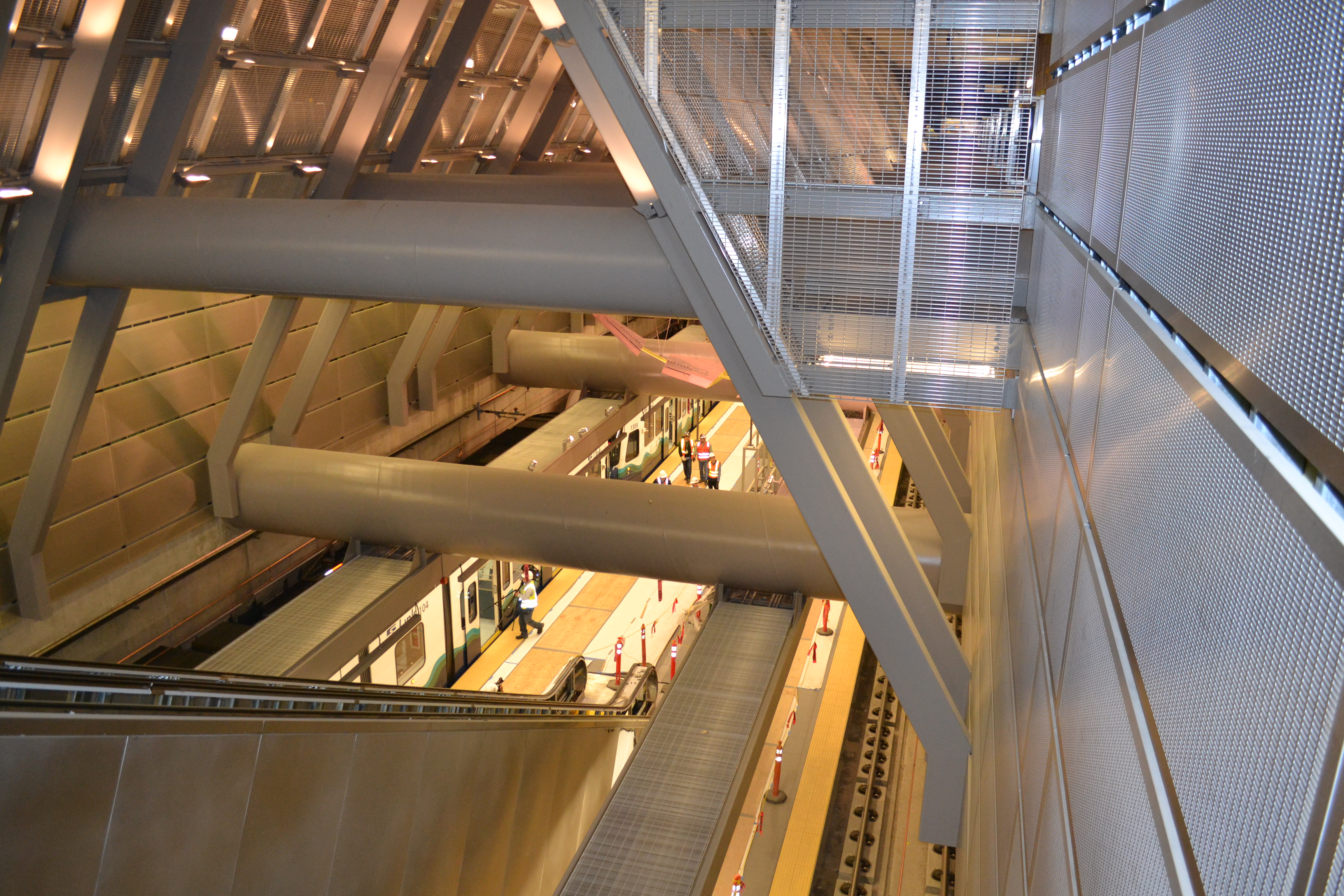
Nice shot of the CH station btw.
Sounder requires a transfer at ID. It’s not so well-timed, either – and, remember, the North Line only runs in the forward-commute direction.
What’s more, this time doesn’t surprise me so much, as the coastal Sounder route is very circuitous.
A case of a tortoise vs a tortoise with a bumb leg.
A month ago, Sound Transit announced the Red Line and Blue Line to be the opposite of what you show here. Did they change their mind?
I think the hope may be to up the frequency to Lynnwood and realize there is quite a bit of demand north of Seattle. Given the drive time southbound is 50 minutes and more regularly at all hours, this would beat bus travel times every day and likely attract new ridership.
I am still a fan of forgetting the light rail spine and make an express rail spine.
It’s going to be absolutely necessary to build an express rail spine north from Seattle to Vancouver BC at some point. The existing Sea Level Line for Amtrak Cascades is hopeless; by the time they finish repairing the mudslides sea level rise will have put it underwater. Might as well start working on the bypass now.
already noted, and fixed
If various tax rates go up as a result of passage of ST3 by the voters, will any of the ST2 projects get accelerated?
I’m a bit confused so hopefully can clarify: will the red line be interlined with the blue line? I was under the impression that the Red line terminated at Chinatown.
The red line will definitely not terminate at International District / Chinatown Station. It will continue on into the Downtown Seattle Transit Tunnel (and therefore interlined with the blue line), and head north, all the way to Lynnwood, I believe.
South of Downtown … the Red Line nee Central Link will operate like every 6 minutes
East of Downtown … the Blue Line nee East Link will operate like every 6 minutes
IDS – North … the Red AND Blue lines will operate like every 3 minutes
Unless plans have changed … there will be a turn back track in the center of the Northgate Stub tracks (until they build further) that will allow ST to reverse trains at Northgate station if they so wish … This could be useful if they do not feel the need to run every train to Lynnwood/Everett … (i.e. not rush hour)
Even during rush hour there will be no need to run all the trains all the way to the northern terminus of the line. Essentially nobody will be commuting from Shoreline to Everett (for example). Nearly everyone boarding the train in Everett or Lynnwood will be riding the train at least to UW. Most will be going straight through to downtown. Quite a lot of people will also be going downtown from Northgate, UW, and Capitol Hill. If all the trains go all the way to Lynnwood and this capacity is actually needed for those riders, then there will be no room for all of the North Seattle and Capitol Hill riders!
It’s pretty simple. If you expect fewer than half of the total riders to ride past Northgate, you can save quite a bit of money by turning half of the trains around there, and there will still be plenty of room on the train for everyone who needs it.
That’s peak hours. Off-peak it will be 8-10 minutes on each line, or 4-5 minutes combined.
Judkins Park Station vs. Jimi Hendrix Park Station. Discuss.
Judkins Park is an actual neighborhood name; Jimi Hendrix Park sounds too much like naming it after a specific person.
We need name a park after Jimi first then the station name will follow.
“We need name a park after Jimi first then the station name will follow.”
The park south of I-90 has been thusly renamed. Google it.
ST asked the public what name they wanted, and the majority feedback was Judkins Park Station. That’s what the neighborhood has always been known as. Jimi Hendrix Station is a bit too specialized and cute, and will be increasingly irrelevant in the next century as the 1960s recede.
I think by 2030 you’ll see significant changes in commuting choices for N. Seattle/S. Snohomish county residents who live within a 5-minute drive of a station. Why wait on a bus to transfer? If you have good relations with a neighbor who is willing to drop you off 1-2 miles away at a station, you can be at work within 30 minutes from Mountlake Terrace-downtown Seattle.
No brainer.
And most people work other places than downtown Seattle. But many of them work in other places Link will go, expecially north Seattle.
“By contrast, those same 26 minutes get a Federal Way rider only to Rainier Beach.”
And people call me crazy for advocating for a duwamish bypass…
… which would save 12 minutes. But the issue is, it’s not that a Duwamish Bypass is useless or a bad idea, it’s that North King has several higher priorities for its transit-capital dollars. Lake City is the next neighborhood after Ballard that needs access to Link. Georgetown is way, way down at the bottom of the list. The bypass would mostly benefit South King and Pierce. So if they want the bypass, they can pay for it. But they have other higher priorities too.
A bypass would not save 12 minutes.
A bypass would not save 12 minutes.
A bypass would not save 12 minutes.
The entire Rainier “detour” — which is only very barely out-of-direction at all (check a map!!) — only takes 17 minutes or less.
A bypass would not save 12 minutes.
A train is not a teleporter.
Goddamn it. Facts, Seattle! Facts!
[ah]
I agree that N King should not be on the hook for the money, since the primary beneficiaries will be folks further down south.
(Also being able to remove parallel I-5 bus service will be an enormous cost benefit in the long run for ST)
And dp, repeating something over and over again doesn’t make it true. Lol Just try driving both routes from Boeing access, you’ll get to DT Seattle with I-5 before you’ll get to Columbia city on MLK, just saying lol
I lived in Japan where everybody rides the trains, guess why? Cause they are fast! There are routes with stations spaced more frequently than link, but manage to provide (50+mph av) high speed service with express tracks. No one wants to travel 20+ miles on a local only light rail train that stops every mile and goes no faster than 30 mph. No one.
Oh, will you drive directly through the mound of Beacon Hill, and then have every signal on MLK bow to your whims?
And on I-5, will you go under the speed limit to match the limitations of urban rapid-transit technology, come to a complete stop at the 2 or 3 hypothetical “bypass” stations, open your doors in the middle of the highway, and wait for half a minute before starting up again
Tokyo has lots and lots of people, and can therefore run different speeds of express service frequently. And still, the overwhelming majority of the rapid-transit-served urbanized area would fit in the linear distance between downtown and Tukwila.
Facts. Immutable facts. Non-straining analogous examples and facts!
p.s. What should it tell you that all those “ultra-fast” Tokyo subway trains you thought were speeding you express across the city weren’t actually traveling very far?
Hmmm… Maybe urban transit isn’t well suited for traveling to the boonies of Federal Way!
(“But waaaaaa. I went to Tokyo and express tracks were so cool! I wanna ride them here!! Waaaaa!”)
Like, fucking christ, Seattle.
Did you actually just try to compare driving via Little Saigon to Columbia City, with known choke points and lots of lights, to driving down I-5? For the sake of “proving” the bypass shorter and faster?
Do you not understand that the time advantage of Link over any surface route to SE Seattle is the whole reason the train has had any success whatsoever.
[Ah]
[Ah]
You’re wrong here, DP. The straight-line distance from SODO station to the airport station is 9.44 miles (source: https://www.google.com/maps/@47.4445349,-122.2968435,17.83z). Assuming a very conservative 40mph average speed for the bypass line, SODO to airport will get there in 14.16 minutes (source: https://www.bing.com/search?q=(9.44%20miles%20%2F%2040%20miles%20per%20hour)%20in%20minutes&qs=n&form=QBRE&pq=(9.44%20miles%20%2F%2040%20miles%20per%20hour)%20in%20minutes&sc=0-43&sp=-1&sk=&cvid=7c318841390f420f91fb34fb817e6ca9)
According to this VERY ARTICLE, SODO to Airport station takes 25 minutes.
And doing simple math, 25 minutes – 14.16 minutes = 10.84 minutes. A bypass would easily save 12 minutes given the average speed of the bypass would be greater than or equal to 43.5692308 MPH (source: https://www.bing.com/search?q=(9.44%20miles%20%2F%2013%20minutes)%20in%20mph&qs=n&form=QBRE&pq=(9.44%20miles%20%2F%2013%20minutes)%20in%20mph&sc=0-43&sp=-1&sk=&cvid=7805bfa750ea4fb58ec14689e3c02cf5)
So, DP, you’re wrong.
[Ah]
Sorry to tell you this, Mr. FactCheck, but I’d point out that you are assuming NO stops, including NO stop at TIBS.
If you add TIBS and a Georgetown stop and take into account acceleration and deceleration, you are down from under 11 minutes to 8-9 minutes. Add in one more stop (South Park? Tukwila Center?) and you lose at least another minute time advantage. If you added a total of six stops between these two locations (what the line has today), the alignment savings would be down to less than 4-5 minutes.
So DP is more right in that the bypass alone only saves a few minutes assuming the same number of stops. You are more right if you assume a non-stop train line segment. The major difference is the number of stops.
What’s more, Mr. FactCheck measures a straight line from SeaTac to Sodo, ignoring all obstacles in the way. If you use the existing track from SeaTac to Boeing Access Road, and then run along the railroad ROW, you get 11.4 miles. Assuming the same “very conservative 40mph average speed,” the train will take 17 minutes to run that nonstop… already a savings of only 8 minutes over the existing route. Add in two stops at TIBS and Georgetown, and you get 19-minute runs… saving only 6 minutes. DP is right.
Is a Duwamish Bypass worth it to save only six minutes?
[Ah]
TIB – Rainier Beach is already non-stop, and is currently scheduled at 9 minutes. (Zach has it as 8; informally I’ve clocked it at 8.5 or so.)
No one is bypassing the already-express. Not going to happen.
But I guess we’ll turn on the nitro boosters to make it the rest of the way to SoDo* in just 3 minutes more!
Or maybe it’ll be a flying train! Wouldn’t that be spiffy!? Let’s do that!!!!!1!
*(Amazing how every one of these billion-dollar non-stop billet-train bypass plans still somehow thinks SoDo is an important station. “Next stop: ShinSoDo! Starbucks, massive garage, some warehouses, Starbucks, espresso repair place, a kitschy diner or two, Starbucks, maybe a wine shop or something…”)
[Ot]
We’re talking about a “What if” scenario here, not a currently existing ST proposal. Indeed, ST recently stated they will not go forward studying a bypass line. But that misses the point, as you do quite often. Let’s take on the claim specifically:
Let’s change up the numbers a little bit: from SODO to Tukwila. The straightline distance between the two stations is 8.22 miles. Let’s assume a Georgetown stop in between: picking a random stop location in Georgetown increasing the distance of this hypothetical line to be 8.25 miles.
Using these numbers, the train would only need to travel more than 51 MPH to get to 12 minutes time saved between SODO and Tukwila stations. I do believe we’d see in reality a smaller average MPH, and thus the 12 minute time saved is a little unrealistic. But it is realistic to get a 10 minute time save as that only requires the train to go an average of 41 MPH.
The heart of the matter, DP, is that you absolutely refuse to give what you believe a realistic average MPH for the bypass line would be. You dismiss 40ish MPH average as unrealistic based on gut I assume. Give us a number that you believe is realistic so we can fact check your work.
Wait, Mr. FactCheck, why are you assuming straight lines? Why not examine some of the plausible bypass routings, such as the railroad ROW from Boeing Access Road northward, or even Tukwila International Blvd? That’s where I got my 11.4 mile figure from.
I’ve no doubt that we could get a faster train if we tunneled all the way in a perfectly straight line… but if we make that implausible an assumption, why not also assume bullet trains traveling >80 mph?
[I can’t even……]
[Good luck, William.]
If ST did that, then I’m fine accepting DP’s point that the bypass line wouldn’t save 12 minutes. But that exactly gets to the heart of DP’s cognitive dissonance. We’re specifically talking about a bypass line to speed up DT trips and trips to the airport.
I am not an engineer, so I cannot determine which alternative ST would use to get to Tukwila via Georgetown. I’m only a person with a maps program and a calculator who can do simple arithmetic.
And the arithmetic is clear: a bypass line could save somewhere around 10-11 minutes.
[Ot]
Oh and this was a particular source of amusement…
“But waaaaaa. I went to Tokyo and express tracks were so cool! I wanna ride them here!! Waaaaa!”
Uhm, I’ve lived in Japan for half my life, speak Japanese fluently, had an internship at Nippon Sharyo, one of the largest train manufacturers in Japan… Directly know people in JR East, Tokyo city subway, Hitachi… Etc lol
[ah]
[Ot]
@d.p.
I don’t have strong opinions on the merits of an airport express, but I do need to point out a few inaccuracies on both sides:
“p.s. What should it tell you that all those “ultra-fast” Tokyo subway trains you thought were speeding you express across the city weren’t actually traveling very far?
Hmmm… Maybe urban transit isn’t well suited for traveling to the boonies of Federal Way!”
Actually the Keisei airport express from Ueno to the Airport runs 34.5 miles as the crow flies, which is quite a bit longer than any distance anyone is discussing here. It also runs (nonstop) through some of the most rural parts of Chiba, which might make even make Tukwila look like a dense city in comparison.
To your point though d.p. this is a *premium* service with fairly expensive tickets and reserved seats. It runs at express speeds (80mph) and has a fairly straight routing and very few stops compared to the regular train lines through the area. To get an equivalent value in our system, we’d need to run a non-stop train straight from IDS to the airport and on different trains and rail lines than we have now. A simple connection on the existing freight lines will not produce this kind of speed boost.
My (not strongly held) opinion, is that if an express to the airport is going to be run, its not ST’s job. We need a functioning transit system first. Tokyo’s N’EX came AFTER Tokyo was already one of the largest cities in the world and had rail reaching every major district.
We have a perfectly usable airport service now. Its cheap, not obnoxiously slow, and is fully integrated into our existing rail system.
It may slower than a taxi outside of rush hour, but then you might say that the taxi is acting like a premium service, right? Why should we spend limited transit resources on making last minute air travel easier?
We should spend more time worrying about connecting places like Ballard, Lake City and even West Seattle before we start thinking about another line to the airport.
Basically agree with what you’ve written, Charles.
Narita is of course an extreme edge case. It isn’t the only distant mega-airport connected to its mega-city by a premium service — Shanghai Pudong and Incheon International come to mind, among others — but as an analogous example it has approximately fuck-all to do with a high-speed bypass on a middling light rail for the benefit of Federal Way commuters.
TG, I am apparently somehow more qualified than you to describe a map, or to offer any insights whatsoever on population density, transit demand, or service geometry.
The Tokyo Metro and Toei Subway never stray further than 12.5 miles from Tokyo Station, as the crow flies. All remain entirely within the Special Wards.
Link already winds up further from Westlake (measured as the crow flies, even) than any part of the full-fledged subway.
Of course, you are obviously preferring to reference the many JR East suburban/regional railway lines that spread across the Toyko Metro.
Funny thing, though… Not only are do these have little to do with your attempted Link comparison — mostly legacy infrastructure, stock and infrastructure more like an electrified New York commuter train than even an RER or S-Bahn, never mind Link — but the high-frequency, high-volume, multiple express/local service pattern line you’re picturing still tend to max out at 15-20 miles, i.e. closer (crow-flying) than Federal Way!
Never mind that all that frequency/commute demand/ability to provide skip-stop patterns results from incredibly high suburban density, making the idea of servicing Federal Way/SeaTac with 2 different service patterns proportionally nonsensical.
Capiche, “expert”?
Speaking of insane misuse of transit modes the Silver line in DC is kind of insane. Even the current end of the line Ruston is 45 minutes from Metro Center when there isn’t congestion due to the clusterfuck of 3 metro lines merging through the center of DC. Dulles will be another good 15 minutes away and the end of the line for Phase II in Ashburn even further. Dulles will feature a nice long walk through the parking garage just like the Seatac Link station. There is zero hope for much all day ridership past Tyson’s Corner. This in spite of the density between Herndon and DC being far greater than anything on Link south of Beacon Hill.
Even more insane is there is an as yet unfounded phase III plan extending at least as far as Leesburg (41 miles from Metro Center).
IMHO the DC Metro really should have been built as Commuter rail past Arlington and Alexandria. Certainly the silver line would have made much more sense that way.
I think this discussion is kind of funny, because folks here are ignoring some rather obvious data: the chart that is part of this post. The chart has lots and lots of stations, and the time it takes to get between them. The funny thing is, none of them suggest that going underground would help much at all.
For example, from the U-District to Westlake you pass by two additional stations, and it takes 8 minutes. From Mount Baker to Rainier Beach you pass by two additional stations, and it takes 9 minutes. So basically, the underground route that includes a very long stretch in the middle (and therefore faster overall, since the train can get up to speed) is a whopping one minute faster.
As far a bypass goes, it is about 11.2 miles from Tukwilla to SoDo, assuming a fairly straight line route over the Duwamish. This is roughly the same distance as Rainier Beach to Highline. Rainier Beach to Highline is supposed to take 18 minutes. Tukwila to SoDo takes 22 minutes. So basically, you build an entirely new line, costing billions, with poor additional stops, all so you can save four minutes? I simply don’t think this will ever happen.
You’re making a bit more sense than you were yesterday, but I still disagree with you on many aspects.
First, I believe that the longer you go, the more important express service becomes (rather than the opposite, like you propose) and there are plenty of examples (particularly around Osaka) of systems that were started as at grade, street running light rail like systems that step by step with overhauls and upgrades has evolved to what it is today (mostly grade separated, high speed, express & local etc) and link needs to progress in the same direction, rather than not evolving and ending up like the Boston green line.
Look at the Keikyu mainline that runs from Shinagawa to Yokohama and beyond. It has more stops than link (over 20!) over its comparable distance (14 miles) and yet it provides faster service between those two points with express service. And the express trains continue beyond the main line in both directions, providing av 50+ mph service. Its 100% possible, 100% reasonable, and as you can see from the success of the various I-5 buses, people travel between major destinations and they like to get there fast. If the headways at low demand stations in between have to suffer a bit so be it. If every ST Bus on I-5 pulled over and made stops every mile, no one would ride them through Seattle to Tacoma.
Yokohama (proper) has 3.7 million people and a density of 22,000/sq.mi.
The city of Tacoma has 198,000 people and a density of 4,000/sq.mi.
Don’t even get me started on Federal Way.
That really is where this comparison of service patterns begins and ends.
—
You keep flogging this premise that a line must behave in fractured ways in order to provide faster outer trip times as it grows in length. But even your own examples never attempt rapid transit-like high-volume service at the distrances at which you attempt to apply them here.
So even the “express” speed you imagine appears to be an illusion. I.e., it is exceeding unlikely that any expedited JR East examples are averaging 50mph, because the lines are not actually long, and the “express” patterns stop nearly as often as Link’s already-too-wide “local”).
You have yet to cite a single example — even in your megacity of record — that would suggest we should be pursuing “rapid transit” at the distances we do. Much less that express/local patterns would improve performance on a line of already insanely scant demand.
That’s what I meant when I said you were extrapolating poorly from experience.
dp
First, thank you for actually making a reasonable argument now, which you really weren’t yesterday, with all due respects.
But I still disagree.
Let me put it to you this way, if there was no Link, if there was no light rail, and all of the demand for public transit on the I-5 corridor were to be served by Buses, would there be a separation of Express vs Local Buses?
Uhm, of course!
Sure, some of the express routes may not have enough ridership to warrant all day service, but no way will every bus going up and down I-5 be pulling over to every bus stop on every exit, that would be insanity!
The same mentality needs to be applied to rail. No one is gonna happily give up their 25 min bus ride for a 1+ hr train ride.
If there was a better, cheaper way of speeding up Link trains? I’d be all for it, but given the restrictions in the RV, the only realistic way of drastically improving speeds (and capacity&reliability) for central link is a Duwamish Bypass. It could be a single track, directional peak-only thing if we really want to save money. If you think there is a better way, fine, but you can’t be serious saying that it is acceptable to have all link trains make every stop from Everett to Tacoma. That’s just silly.
Also, I just want to correct you on some facts:
-JR Tokaido Line: 51.6mph Av 123.3 miles Maibara-Himeji
-Tsukuba Express: 57.4 mph Av: 30+ mile stretch from Tsukuba-Kitasenju
-JR Tokaido Line: 51mph Av: 14 miles Shinagawa-Yokohama
-JR Keiyo Line: 48.6mph Av: 26.7 miles Soga-Tokyo
Perhaps the Shinkaisoku (Maibara-Himeji) is the best example, it traverses a lot of suburban sprawl without making any stops, only serving urban city centers along its 100+ mile journey (at no premium charge)
If I lowered the bar to 45 or 40mph av there would be even more such examples.
Also, regarding your comment about population density, you have a point, except Tokyo and Yokohama are connected by nearly 10 frequent all day rail lines and numerous tolled express ways, so each rail line only gets a fraction of the demand, and Express service is still justified.
Personally I think its distance that warrants and justifies Express service, not overall passenger volume. But that’s just another one of our disagreements I suppose.
TG, thanks for your reasoned argument as well. I agree that something faster than an all-stops Link train needs to be in place between Seattle and Tacoma. My point – and, I think, d.p.’s point as well – is that the Duwamish Bypass won’t be faster enough to make any appreciable difference. It’d save less than eight minutes, at significant cost both in terms of money and in terms of service to the Rainier Valley.
I think a far better option would be to improve the Sounder tracks and run all-day Sounder. We’d get an express service (only five intermediate stops!) serving a different part of the county, with higher top speeds, that Amtrak Cascades can use as well.
With all due respect, citing as your first example a (seemingly arbitrarily chosen) subset of the corridor between Tokyo, Osaka, Kobe, and western Honshu discredits almost any comparison to our region which follows.
With two megacities and a handful of other very large and very dense cities anchoring that corridor, there is no comparison even to SEA-PDX intercity travel, much less to intercity travel within Puget Sound itself, and much, much, much less to Link.
If you want to have a discussion about how the New York-D.C. corridor can support high train volumes, various stopping patterns, and potentially high speeds at long distances on the basis of that example, then be my guest… because the Northest Corridor already does that!
However, such an example is really, truly, profoundly irrelevant in this place and this discussion.
And yes, I just figured out that your selected sub-section is the one operated by JR West. Which just happens to include the trifecta of Kyoto, Osaka, and Kobe at its center, and a string of less famous but well-urbanized pearls the rest of the way from bureaucratic boundary to bureaucratic boundary.
My Northeast Corridor comparison stands stronger than ever. Ignoring the weak-sauce Shinkansen that is Acela, the Northeast Corridor’s population spread and development form support a complex overlay of Northeast Regionals locals, relatively quick Northeast Regional semi-expresses, and commuter trains from New York to Trenton, Trenton to Delaware, and Baltimore to D.C.
All made feasible by a corridor that looks and acts far more like your chosen example than any corridor around here.
And all having nothing whatsoever to do with anything that looks like Link.
WIlliam C
Thank you, that’s actually really a great idea, honestly if I could chose between continuing building Link in its current form to Everett and Tacoma, vs investing all that money into improving & operating (All Day? Electrified?) Sounder, I would. I just worry that the suburban politicians on the ST board won’t be too happy to see Seattle getting Ballard & WS LRT while they have to “make due” with Sounder. I know, its ridiculous, but its politics… Sounder is a much better mode to serve such distances.
dp,
Here, I’m curious; What would you do? if you had $15B? What would you do with the money? How would you plan on keeping the suburban politicians happy while not wasting money on expanding an ever expanding but uselessly slow “spine” ?
Also, you’ve made some points, but I still disagree with you on many stances.
But regarding my question, I’m not trolling, I’m genuinely curious.
Chris: Dulles is a special case in Washington, DC. It gets a *lot* of traffic, and it’s in a *stupid* location which is not readily accessible by rail unless you build the rail from scratch (as they are doing).
There are currently some weird proposals to extend the Silver Line past Dulles. These will not happen. As with the Blue Line to O’Hare in Chicago, Dulles is the natural end of the line and it *will* end there.
With a Duwamish bypass, those same 26 minutes get a Federal Way rider to the south end of Boeing Field. The time savings to downtown would be miniscule.
A Duwamish bypass would make a perfect connection from SeaTac to DSTT2
So we should ignore Seattle’s other urban villages again because a Dumwamish bypass is Very Important?
It’s only Quite Important IMO.
OK, let me see if I get this:
It is quite important that an express be built that cuts about 6 minutes from downtown to Federal Way, so that the express trains are able to reach a Quadruple S Curve that specifically avoids actually directly serving most of Federal Way?
Really shows the effect of at-grade in rainier valley. Link will be pretty darned useful in Shoreline and Lynwood, despite the freeway alignment. The same cannot be said of federal way.
I estimate you might save 4-5 minutes at most with being able to go 50-55 mph through Rainier Valley. I am not exactly sure how to do an Excel graph of the acceleration and deceleration profiles as a function of time but I would like to try and see how that works showing travel time and distance on the x, speed on y.
Also keep in mind dwell time. Maximum speed doesn’t really matter much for the distances we are talking about. From Mount Baker to Rainier Beach takes 9 minutes, and Stadium to Mount Baker takes 7 minutes as does Northgate to UW (all trips with the same number of stops). My guess that if this was in a tunnel, it would go a minute or two faster (at best). The difference will be even less when the station is added at Graham.
The biggest benefit would be the potential for much lower headways. We could run those trains a lot more often.
2 minutes saved, tops. And trains are going to go 55 mph down MLK over a few dead bodies. Literally. Just study the safety record of LA’s at-grade light rail segments.
55 mph assumes grade separation. I.e., elevated, tunnel, or trench. Not dead bodies.
That’s because of how far Federal Way is. People think of Lynnwood and Federal Way as equidistant, but Lynnwood is the distance of Kent, and Federal Way is a bit less than Everett.
Link will not be that useful to Shoreline and Lynnwood.
It’s a highway-commute expediter, and nothing more.
Lynnwood Link will certainly help transit riders in Lynnwood by freeing up gobs of service hours currently being used on express service that will go away in 2023.
Sure, and it will be faster for most of those commuters to boot.
This does not necessarily meet the threshold for describing it as “pretty darn useful” in a rhetorically generalized sense.
@d.p. how useful link will be to Snohomish County depends on how many bus hours it saves them and how they are able to re-invest those in a reliable bus network.
For Shoreline… it depends on how KC Metro reinvests hours to connect to those stations… if they are even built in such a way that they can be used for bus transfers. Shoreline riders seem much more likely to demand big garages at this point.
It does seem that Shoreline is investing in more bicycle infrastructure to connect bicyclists to nearby stations at least.
Even if Metro and CT don’t do anything, Link will stop at 185th which no all-day express bus does; it will be 6/4 more frequent than the 512; it will be immune to freeway traffic; it will allow trips from Shoreline/Snohomish to Northgate and Roosevelt; and new one-seat rides to Capitol Hill and the airport. That has got to equate to higher ridership; people won’t just watch it go through there and not use it.
A few things jump out at me when I look at light rail to the northern suburbs:
1) Not that many people will live close to the station (even with the zoning changes).
2) During most of the day, the buses run very fast from the station to downtown. This is because the station is next to the freeway.
3) Likewise, during much of the day, driving on the freeway even in a regular lane is fast.
4) During the times when buses move relatively slowly (20 to 30 MPH) on the freeway, simply getting to the stations is also difficult. For a lot of people, the tough part of their commute is getting to the station (whether by car of bus) not getting from there to downtown.
5) The UW is major destination, and is north of downtown Seattle. Ballard is north of the UW.
So basically, it depends a lot on what we do after building this. A twenty minute drive to a park and ride followed by a half hour train commute really isn’t that much different than the bus right now. A little faster and a lot more reliable, but not a huge difference. Getting to the UW is also a bit easier, but those two destinations actually have decent bus service right now. The big question is whether it will be easier to get to the suburban station, and how the rest of Seattle’s bus and rail service improves. Without a doubt there will be people who travel to Capitol Hill and will like this. But with only one station, the numbers won’t be huge. Northgate has a fair amount of medical offices (and a college) so they will be significant as well. But not that many people will travel from the suburbs to the other stations (Mountlake Terrace, 145th, Roosevelt, etc.). Which is why transit on the other end is just as important. Just as housing is dispersed in the northern suburbs (and not very close to the stations) the destinations are dispersed in Seattle (and only a handful, as mentioned, are close to a station). The role transit plays in connecting the city will play a big part in whether this works that well for those in Lynnwood. For example, if nothing changes, then someone from Shoreline will probably drive to Ballard, especially if the trip takes place in the middle of the day. But if UW to Ballard light rail is built, then taking transit makes sense.
So basically, this, by itself, won’t be a huge change. But if improvements are made on either end it could be significant.
It seemed a lot more natural the way you had it. But whose idea of a sick joke was it to send the Blue Line into the “red” Eastside and the Red Line into “blue” Seattle anyway???
Would have been better to use Purple and Gold for the line branding…
Thats what I asked … but got no reply from Sound Transit
Sound Transit seems to usually not respond to comments from their constituents — even to the point of not even acknowledging that the comment or question as even been received. I and many others have had the same problem.
It’s not personal; it seems to be an accepted culture of ignoring the public — and I think it’s a big problem with ST. Maybe if the staff and board would understand that ignoring comments is a good way to encourage more people to vote “no” on ST3, their attitude to comment responses would change.
FWIW, I sent in two comments by email about the proposed new route 541, and got an email response after a couple weeks promising to take them into consideration.
(I was asking for it to be timed with the 542, and for it to share the RR B stop at 35th and 156 on the Microsoft campus.)
It’s hard for me not to think of East Link as more appropriately red. But I guess I’ll get used to visualizing the colors on the map.
LOL – Bellevue/Redmond/Renton etc. voted almost 65% for Obama in 2012, are represented by 5 Democrats (out of a possible 6) in Olympia, and elected Adam Smith and Suzan Delbene to the US House… maybe you’re looking for blue and deep blue for the Eastside and Seattle respectively?
Unless Link is running out over the mountains, it is serving a very Democratic population on both sides of Lake Washington.
Also Seattle has a RED COMMUNIST on its city council. Colors, what’s up with them, am I right?
Color selection is a complex topic.
With RapidRide using red and ST is not using red in their logo, I’m really surprised that there is a red line. I would have suggested gold or forest green.
Purple is a color used in many commuter rail systems in other parts of the country. Still, it could be used.
I think the ST should pick between a blue shade in their logo versus the famous Microsoft blue screen blue. Nevertheless, both are blue and seem appropriate for East Link.
Tacoma Link already uses purple, Sounder uses two shades of green, RapidRide uses red, Swift will be switching to colors soon (blue and green)…
I think we’re going to need to whip out a wood palette and start mixing colors to see what would be suitable. My first suggestion is a Gray/Grey Line to really drive home the whole overcast weather stereotype.
Orange or Gold would seem to be next. Gold is a UW color, too.
@Al S,
Exactly my point. East Link and Central Link should be branded as the Purple and Gold lines respectively. Doing so effectively eliminates these silly political games, and it would honor the UW. And it would serve as a great way finding guide to one of major transportation destinations. A win all around.
+1 to Purple and Gold lines! But then, would Ballard-UW be the White Line?
Is now the time to pick colors?
Who should we honor the UW? It put the station in the worst possible location, wouldn’t allow an extension of the Triangle pedestrian tunnel, won’t allow a few more layover spaces for Metro, and is hesitant to move the Stevens Way bus stops closer to the station because views of Mt Rainier are more important than pedestrian mobility. Then there’s that laundry facility blocking TOD next to Mt Baker Station. Couldn’t it at least agree to long-term goal of relocating the laundry or turning it into a multi-use lot with the laundry and more urban things? It’s not like it’s everywhere that three major streets cross (Rainier, MLK, and almost 23rd), and that’s the best place for a station and residents using the station. So I don’t see much reason for purple and gold lines. If there’s any purple and gold it can be in the university station.
Angle Lake to UW in 44 minutes?
Kent Valley becomes a frat-sorority town!
44 minutes away from the university? That sounds a little far… do you know any similar examples?
At 13 minutes Stadium Station to UW Station, nobody can seriously propose the CLink as a neutral site for the Apple Cup ever again. (And I still see more Longhorn sportswear than Huskies sportswear around town. I think I get it why the NIMBY folks hate Texans.)
I’m stunned that you’re so excited about south Link. It will never be as fast as the 150 if you’re coming from downtown Kent or east Kent. I hope everybody in Kent and Auburn is as dedicated to using Link as you are.
Have you ever ridden the Southcenter loop of the 150 route?
Even if LINK’s duration is the same, it won’t seem the same.
Suburbanites have greater rail bias than city dwellers.
If the plan is to hide-and-ride in the Ranier Valley, Link is probably quite a bit faster than the 150, even coming from Kent.
Why does the blue line go all the way to Lynnwood? I thought it would terminate at UW station or Northgate at the northest (if that’s even a word). But does that mean Lynnwood – Seattle will now get twice as much service as Federal Way – Seattle? If we’re going to through route east link with one of the branches of the red line, then we should probably give the north red line destinations (UW, Northgate, Lynnwood) the same number of trips as the south red line destinations (Rainer valley, SeaTac airport, Federal Way). Maybe blue line Lynnwood – Overlake, green line Federal Way – Overlake?
But I think terminating blue at UW is sensible, since that will complete a common commuting path (Bellevue – UW), as well as increasing service between downtown and UW. I think going to Northgate or farther from east link warrants a transfer. The good news is that such a transfer would be super quick and easy given its frequency. Transfer to south red line would take longer because red line southbound is on the opposite side of the platform as blue line westbound.
There’s no turnback between Stadium and Northgate. So all East Link trains will have to go to Northgate. As I said elsewhere, ST was originally going to terminate off-peak trains at Northgate but then changed it mind and sent them all to Lynnwood. It could change its mind back later. But no trains will terminate at UW; there’s no room for them to turn around.
Why don’t they build a turnback then? This is quite a restriction. There is no turn back… because the whole thing isn’t built yet. Why not just build a center track long enough to hold one train, have a platform for the driver to switch sides and blammo, you have a turn back.
Or how about Sound Transit tells south king voters that the reason they will get much less service than North-King/Snohomish will is that Sound Transit never bothered to build a turn back because… reasons.
Also, there presumably is a turn back after Westlake station because… well.. trains are already turning back. Why not terminate the blue line there (Westlake) and have UW commuters transfer to red line to get to UW? Seems to make a whole lot more sense to me than have every single blue line train go all the way to freaking Northgate.
Although this is from the same Sound Transit that chose I-5 for FW link, no bad decision from Sound Transit should surprise me anymore.
There’s no turnback because double-frequency between downtown and Northgate was considered important.
Northgate to UW is 7 minutes. Lynnwood to Northgate is 13 minutes. Ridership to Northgate will not be anywhere near ridership from UW to downtown, but it will still be substantial, even in the middle of the day (with the college and the medical offices nearby). Northgate is a reasonable turnaround spot.
The one weird thing is this might effect Lake City. Given the high number of people in Lake City, and the nature of the corridor, a strong case can be made for frequent transit from Lake City to Bitter Lake all day long. This would connect at a station at NE 130th. But if the train becomes less frequent, does this change the frequency of this route? If so, do other routes (e. g. Lake City to Northgate) get a lot more frequent? Or maybe this argues for keeping the high frequency trains to Lynnwood — are there any other turn back areas?
Northgate will have a third, center siding track that will allow trains to reverse direction (like Rainier Beach and Stadium Stations) …
“Why does the Blue Line go all the way to Lynnwood?”
This is just one map. ST will decide where to turn East Link trains back once they get sufficient operational data. It has to be a location where there is a turnback track however.
There are no benefits to riders in requiring them to transfer at UW as opposed to running the trains to at least Northgate. I have no reason why you would want that.
Zach, Thanks for presenting two often un-discussed items here: The line color reference and the net travel times.
I would note that this is looking at travel time from the train driver’s point of view, but the rider has to negotiate getting to platforms then waiting fro the train. For example, the lack of down escalators adds travel time to one end of the trip. The SeaTac Airport Station platform takes several minutes to reach for any riders going to and from the terminals.
Though the numbers for the red line don’t look so good for Northgate in aggregate, most of the stations that take longer to get to are on the south end, well past most of the shopping and employment centers most folks are likely to frequent. In addition, access to the blue line gives incredible frequency between Northgate and ID/Chinatown which include access to most of the shopping, job and entertainment centers that will be easily accessible from the line.
All of the stations between Northgate and ID/Chinatown benefit from a one seat ride to anywhere else in the system. Its also important to note how the bus network will map over this when its fully functional.
It would be interesting to see how these numbers play out when combined with the blue line and all BRT/Bus exclusive lane systems that are planned through the city.
The Graham St station has been identified as a potential Move Seattle levy item, yes?
Yes, but not likely with enough money to actually build the station. I suspect they’re going to use that for matching federal grants.
And it’s on ST3’s potential project list.
I was expecting higher travel times from Federal Way, so I am pleasantly surprised. My current ride from Star Lake to IDS (via bus 190 express) is 55 minutes in real time vs. the 39 minutes on Link according to the above chart, saving 16 minutes or 30%. Not bad!! Sometimes coming home it can take an hour or more, so the reliability of Link can earn it brownie points.
Huh? The 190 schedule shows 23 minutes from Star Lk to Spokane St at 7am. Add 6 minutes to get to IDS makes 30min +/-, NOT nearly double that you say in your real world.
39 is more than 30, No?
That timetable is a lie! Maybe in an alternate universe when there’s no freeway traffic will that timetable ever work. I take this route every day and my 6:46 bus always gets to IDS with typical traffic around 7:40. Throw in random car accidents or rain or both and of course it is worse. Link will be faster and more reliable based on the above chart.
Any other 190 riders out there, as I want a second opinion.
The 178 at that time of day (FW-IDS) is pegged at 35 min.
ST’s 577 is 44 min from FW to 4th/univ, so about 37 to IDS.
Schedulers at both ST and Metro look at actual v. runcard times to see if some schedule maintenance is required each shake-up. I’d be very surprised if the 190 runs 55 min each day and the schedule has never been changed to reflect that. It effects drivers breaks, turnback times for the next run, bus availability, etc, etc.
Look at bus schedules over the decades. They all take much longer than they used too.
BTW, some here (eddiew and others) lobbied for taking the busway traffic off I-5 NB at Michigan St, then dropping down to an extended busway south of Spokane street. That one change would save countless time and money on the HOV/Spokane weave each day that you legitimately complain about. It was needed 20 years ago, and is needed more than ever, and certainly competes with the Link Duwamish teleporter bypass.
I’ve sat in the same stop and go traffic on many a morning in the HOV lane.
Peace Brother!
It’s actually 40 minutes from star lake to IDS. My initial calculation was from Redondo heights which takes 15 min extra. So assuming link freeway stop will be at star lake, it will literally be about the same time, ~40 min. :(
I was going to say 44, but that’s counting from Westlake. You save significant time by starting from Intl Dist: it makes the entire hop to SeaTac less than half an hour.
39 minutes vs 30 minutes is not the discussion point. People consistent, reliable travel times. Not knowing if a 8 mile trip will take 20 minutes or 90 minutes is what is most frustrating. Spending millions to make a trip 5-10 minutes faster is ridiculous, make it a consistent, reliable time and more people will use it. Current environment is Metro is stuck in the same traffic as cars, no reason to use Metro it will always be slower than driving a car.
Bingo.
I’m a bit concerned that LINK light rail in its current form may not be the best solution for the central spine, although the decision seems to have already been made. Will it have enough extra capacity if the 57x and 59x series of buses are eliminated to handle all the riders, not just from Tacoma, but Federal Way, Sea-Tac, Rainier Valley, etc. all heading to Seattle without the added expense of running at high frequency all day, every day? How will a potentially 75+ minute long ride (my estimate, Downtown to Downtown) in a frequently stopping, crowded, urban light rail car go over with Pierce County riders, who have come to expect a motor coach, with high backed reclining seats? Will the funds to operate Link come from eliminate of the 57x and 59x series of buses? or will they come out of some other pot of money? I have heard that these issues have came up in the ST 3 planning process, so it will be interesting to see what happens. Although $5 says the Central Spine will be completed.
Yeah we needed a four track high speed express/local train service. But with link, the train will be competitive from federal way and north despite what the bus timetables say. Apparently the time tables haven’t been updated to reflect real world traffic conditions. But 75 min from downtown tacoma is slower than express and sounder. And I think st station ridership shows express buses at tacoma dome having more riders than sounder which I thought was odd. So I doubt a longer time on link will alter anybody’s commute patterns at tacoma dome and the 590s will stay.
FW to IDS 20 miles on I-5. Your mythical hour long current trip is averaging 20mph in the HOV lane and busway. If true (BS aside), then lobby the Transportation Commission to follow the law, and goto 3+ to ensure the lane runs at more than twice that (45mph) as required by LAW.
ST Express has significantly lower fares than Sounder. (That may suggest ST wants to keep passengers on ST Express.)
Mic- I tried taking the 577 from the fwtc and that route doesn’t go along the busway. It gets off Seneca or something and then gets stuck in downtown traffic going north…and then turns south along 2nd…even their own time tables reflect about an hour from fw to IDS (2nd and Jackson).
“the train will be competitive from federal way and north despite what the bus timetables say”
The timetables may be wrong sometimes, but whenever I take the 577/578 (which is occasionally) they’re on time.
I think ST can count the number of people on the buses and make sure there’s enough space on the trains. Frequency is a good thing in itself because it makes transit more effective; that’s the advantage of a train that can replace several busfulls of trips at once, it can run more often than the buses did.
As for how Pierce County riders will accept it, they’re the ones tearing down the walls at ST headquarters clamoring to get the spine finished. If they haven’t figured out by now that Link will be slower than the buses, it’s their own fault because they only have to look at current Link: 37 minutes Westlake to SeaTac when the buses are already reaching Federal Way at that time. Tacoma seems to want Link more to entice people/businesses/shoppers to Tacoma than as a slow route to Seattle. We don’t know what would happen to the 57x and 59x routes because ST hasn’t said. It’s clear that the 550 and 512 will be deleted because Link competes with them time-wise, but it’s not clear what will happen to the south end routes that Link doesn’t compete effectively with. Maybe ST will delete them anyway and slow people down (or convince them to take Sounder), or maybe ST will keep them peak only. I’ve told ST that they need to clarify this before the ST3 vote because it’s a material issue. And in general, we need to stop this uncertainty about what the buses will be like until one year before the Link segment opens; we really need to know much earlier.
I find it highly entertaining we can’t even agree on how long (avg) it takes to get an express bus from IDS to FW, much less Tacoma. The post is about transit times between the same points (and others), and supposedly we’re spending billions and billions to replace slow, expensive, unreliable, crowded buses with trains that do better.
Go figure!
Very nice graphs, thanks!
I note that the Rainier Valley stations are almost due north of SeaTac and TIBS, at is is in real life. I think Zach has done a great job to make this map, and show how crazy the Rainier Valley “jog” is in the ST graphics. I-5 is not a true north-south roadway and Central Link stations mostly are located in a true north-south alignment (realizing that the jogs in Tukwila only affect track alignment and not stations).
For example, take a good look at the ST3 graphic here! Rainier Valley is an eastward jog, but UW is a straight line!
http://soundtransit3.org/shaping-st3
Would 73 minutes make it the longest light rail line (either by distance or travel time) in the world? Anyone know?
Define light rail.
The Siemens S70 cars used as light rail cars in a number of USA cities would be legal on main lines in Europe. Once you cross that boundary what do you call light rail?
Would it be out of the question to have peak/counter-peak “express” trains? For example a “red” line train that went from Everett to Northgate to UW etc., skipping a few stops along the way.