
Imagine an alternate universe for a moment. In 2023 you come to the opening day of 145th Street Station in Jackson Park. You wait 15 minutes for a 2-car, rush-hour train. The train departs along 5th Avenue Northeast, going through 13 at-grade crossings just en route to its first stop at Northgate. 110 minutes, 33 miles, and more than 100 additional at-grade crossings later, you arrive in Federal Way, having traveled on the surface through Roosevelt Way, Eastlake, South Lake Union, Stewart St, 2nd Avenue, 4th Avenue South, East Marginal Way, and SR 99. That doesn’t sound very appealing? In a nutshell, I’ve just described Portland’s MAX Blue Line. The actual train we’re building will be twice as long, come 5 times as often, and get you to Federal Way a full 50 minutes faster.
We frequently wonder around here why our transit-building schemes are slow and expensive, and I’ve offered my best attempt at the process side of the equation already. But today I want to propose another reason: to put it bluntly, we’re building the good shit and nobody else is.
This is not intended to troll the commenters ready to erupt in apoplexy over legitimate microfights on urban stop spacing or the merits of suburban rail, so let me explain. The Portland example above is intended to show that our peer cities in the U.S. tend to cut corners we aren’t cutting, enabling them to quickly and cheaply build low capacity, infrequent, primarily at-grade systems. By contrast, only two regions (Seattle and L.A.) are building high-quality, frequent, grade-separated transit in the contemporary United States, and both have the price tags to prove it. ST2 and ST3 are grand experiments to determine if the public has the appetite and the open pocketbook to build yesterday’s quality at today’s prices.
Let’s look at some data for 5 peer cities expanding their rail networks today: Dallas, Denver, Portland, Minneapolis, and Los Angeles.
Frequency
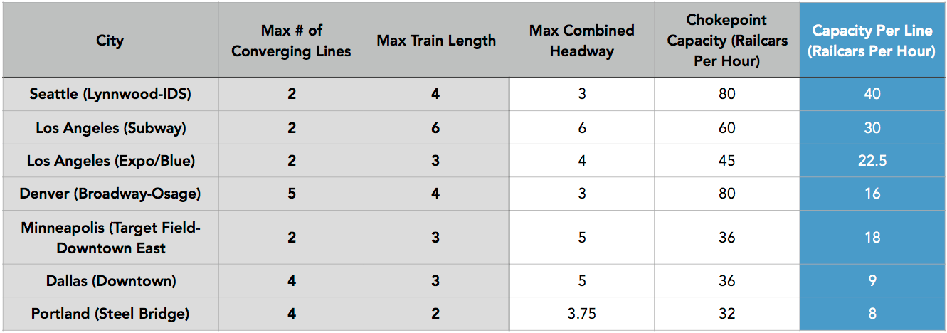
Simply put, no other agency in the country is planning two new 6-minute lines the way we are. Dallas is the worst offender here, with each of its 4 lines running every 20 minutes in order to accommodate 5-minute combined headways on the surface streets of Downtown Dallas. In Denver, heavy reliance on legacy freight corridors has left 5 lines (C/D/E/F/H) running every 15 minutes to share the same double track between I-25/Broadway and Downtown Denver (though their trains are fast and reliable). In Portland, shared use of the Steel Bridge limits 4 lines to 15 minutes each. Minneapolis does better, with 10-minute headways per line sharing a few stations in Downtown Minneapolis, but likely could not expand significantly.
Los Angeles does well, with its main subway running every 10-12 minutes all day, and the Red/Purple lines interlining for 6-minute service east of Vermont Avenue. Its light rail lines escape the other cities’ fate by operating mostly independent of one another.
But Seattle is doing something different. We could probably follow other cities’ path and cut frequency to 15 minutes on our nascent Red and Blue lines, build the Green Line to run every 15 minutes in the current tunnel, and have combined 5-minute service between them. But instead we’re choosing to have our branches be as robust as other cities’ trunks, and we’re not only foregoing surface rail, but we’re proposing to build a second subway instead.
Capacity
Portland is similarly instructive when it comes to capacity. Its trains will never have more capacity than they day they opened – Portland’s 200′ city blocks and reliance on surface alignments ensure that. Whereas we are building 4-car, 400′ platforms at every station and running each line 2-4x times as often, for 4-8x the capacity. Surface rail is as limited as the shortest block along its alignment that citizens are unwilling to close off.
Grade Separation
Our topography helps us not cut corners, as our hilly terrain has given us a dearth of legacy freight corridors and also precludes many surface alignments due to grade. But it’s still striking seeing other new light rail systems poke along their Downtown arterials. Again, Seattle and Los Angeles are the only non-legacy systems building substantial new subway and elevated capacity.

To be clear, none of this is saying we’re building in the right places, or that we are self-evidently superior in any way. Those questions are left to the reader. The intent of this piece is to acknowledge that we are choosing to be the tortoise rather than the hare. ST2 and ST3 are an exercise in delayed gratification for a better purported payoff.
We are choosing to do the hardest possible thing, to build new, grade separated, truly high capacity transit. We’re doing so in a wealthy region, through and under valuable land, while appeasing every environmental regulation, mitigating every property owner’s complaint, showering goodies at cities along the way, and securing the majority support of a very engaged citizenry.
The legacy systems of New York and Chicago, etc, built hard things the easy way, with often callous disregard for human life and the environment. Today our peer cities are building easy things the hard way, creating inferior products while encumbered in the same process mess. We are choosing to build hard things the hard way. That is by definition torturous, but it’s also the only way to get real value out of what we’re paying for.
Wow!! That was a 5 star article! It makes me feel better that for all the effort we’re putting into the ST expansion packages we’re getting a higher quality system out of it than most of our peer cities.
Transit supporters need to make this clear to voters. When they ask why ST3 is so much more expensive than other systems, we need to tell them it’s because it’s so much better.
Exactly, ST3 will rock!
Seattle really is building “Light Metro”, not the “Light Rail” that other cities tend to build. The difference is pretty clear even to the most casual transit user.
It’s also interesting to see ridership trends. Link already carries a very large percentage of what the entire MAX LR system carries — even though the MAX system is substantially more mature with much larger coverage and number of stations. A lot of that has to do with demographic differences between our two cities, but given that, it is clear that a Link type system is the better choice for Seattle than would be a surface running MAX type system.
In any case, building to Central Link design levels needs to be the minimum standard moving forward. It works, and it fits the city (and regional) need.
Well put Zach. We compare ourselves to NYC and say wow, what a great system, but although the NYC subway is functioning, there are so many intractable problems.
Complete ADA accessibility may take centuries at the current rate. Few stations meet modern fire codes. A smart transit card fare system is still many years away. The quality of life issues are dire: leaks, rats, smells, heat, and noise are daily reminders of the deferred maintenance and construction shortcuts that were taken decades ago.
ST is building to avoid most of those issues. Some like ADA and fire codes are table stakes. Others are simply implementing modern standards and best practices. We won’t be NYC, but in many ways that is a good thing.
I’ve used many subways in many countries, and the NYC subway is by far the dirtiest and most disgusting.
But extremely effective in transporting people. And that’s the main reason, what was it built for.
The headways for the MAX system are off. During rush hour, there are sometimes 12 or more blue line trains per hour, with about 50 trains going across the steel bridge in an hour.
That doesn’t help at noon or 8pm or on Sunday — most of the week, or what it takes to convince people to downsize their number of cars rather than just using transit to a 9-5 job. We need to focus on the minimum off-peak frequency until 10pm, then peak hours will take care of themselves because the commuters will demand it and are more numerous advocates.
The problem with people using MAX outside of peak (or getting to a 9-5 job), is that it’s not really set up for that. If there was a line that didn’t go downtown (for example, the current routing of line 75: https://trimet.org/schedules/r075.htm), the line would be hugely useful for non-commute trips. The added benefit of having a route like that is that it would connect all of the current MAX lines, and would add a sort of “outer loop” to the system (where the streetcar loop functions as the “inner loop.”
I don’t ride the trains very often, mostly because there isn’t one where I’m going.
The fact is that MAX train capacity isn’t quite as bad as has been listed in Zach’s article. That is ethan’s point. You can do a lot to run a lot of trains over a single line if you have to do so. This is especially the case with Link since so much of it is separated from auto traffic or other cross traffic.
The unfortunate fact with MAX operations is that TriMet aims for cheap operations, and scales back frequency of services pretty badly in the evenings, and in that I agree with Mike Orr.
The train frequency is kind of nice to have, but four car trains running a bit less frequently during peak and using the service hours to increase the frequency in the evenings would sure be nice.
Four-car trains would straddle two intersections in Downtown PDX and post interesting if not fatal operational challenges for signals, etc, yes?
Folks, I don’t think we want to copycat Portland’s MAX.
I think we want to let Dow Constantine be the Head Coach and Peter Rogoff be the Offensive Coordinator for a team that is going to score many touchdowns… for us, not Portland, not Santa Clara and not NYC.
Folks, I don’t think we want to copycat Portland’s MAX.
I think we want to let Dow Constantine be the Head Coach and Peter Rogoff be the Offensive Coordinator for a team that is going to score many touchdowns… for us, not Portland, not Santa Clara and not NYC.
Yes, it would not be possible on the surface in downtown (Lloyd Center could) without closing off a few intersections, but that wouldn’t hurt my feelings too much.
“Four-car trains would straddle two intersections in Downtown PDX and post interesting if not fatal operational challenges for signals, etc, yes?”
That’s looking at it the wrong way. It should be underground downtown, and then four-car trains wouldn’t be an issue. (Although you’d have to design the stations to accommodate them.)
It’s a station every two blocks, so it would wind up being one continuous station platform from the Lloyd Center to Galleria. Oh, you could probably skip the Steel Bridge, so maybe two continuous stations.
One continuous platform… Chicago did that with the State Street Subway and Dearborn Street Subway.
Bravo. I think the light rail network getting is definitely among the best in the country, even if there are some complaints about how it’s being done.
Incidentally, isn’t Honolulu also building a grade-separated light rail (or light metro) line?
Yes. 100% elevated I believe.
They also have the price tag to prove it.
Honolulus line is quite different. It will be a driverless system based on the tech used on Copenhagen’s metro.
Similar to Vancouver’s system?
Yep, a lot like Vancouver SkyLink.
They are fighting tooth and nail to actually get it built because there’s an insane amount of opposition. Construction is very expensive because Hawaii has to import almost everything (steel, concrete, etc.)
Yes. It’s also a huge clusterfcuk (not related to the design).
http://www.nytimes.com/2016/03/21/us/hawaii-struggles-to-keep-rail-project-from-becoming-a-boondoggle.html?_r=0
Really good points, Zach. In the context of what is being built in similar places today, Sound Transit is doing a pretty decent job.
I don’t know stop spacing can be dismissed as a micro-issue because it says so much about what a system’s overriding priorities are (and therefore the extent to which systems are comparable). In the case of MAX light rail in Portland, with the exception of downtown and North Portland, MAX has only been put in places where, no matter the stop spacing, its success (measured in terms of the number of people who will find it useful) will be limited because its trunk routes are in freeway rights of way and old freight rights of way—places where there aren’t many people around. For Link on the other hand, there was much more pressure to create new right of way (because of the geographic and political concerns you raised) that goes through places where a lot of people (the Valley, Capitol Hill, U-district, and even north of there to an extent) are, where denser stop spacing would significantly improve the usefulness of the system. But the system has to balance regional mobility with local access and it has chosen to do so by placing fewer stops.
To the point about comparing systems, I guess what I’m saying is if Portland and Seattle had to redo both of their rail systems and serve roughly the same areas but could have more or fewer stops, you wouldn’t do a whole lot different in Portland (and the results wouldn’t be much different either), whereas you might in Seattle (and the result could be a more heavily used system). With the mandate to create new right of way, Seattle’s potential to build something useful to more people was much higher than Portland’s.
When they built the green line through downtown Portland, it was built with stops every four blocks instead of every two blocks like the blue line was.
I’m pretty sure that if the blue line were built today a few of those stations would be missing.
And I know TriMet would love to remove some of those…and it really wouldn’t impact access because they are so close together.
Excellent article.
I still question the value of much of this process, but strongly agree on the point that we’re ending up with a high quality product. I’d just say we’re ending up with a high quality product despite the process, not because of it.
Excellent chance to get an important definition, Matt: What do you mean by “this process?”
Mark
Covered pretty well in a past post here as well as yesterday’s podcast. The process I find most egregious is environmental impact studies (used more as “save our parking” studies than saving the environment), but honestly even our long rounds of public comment slow things way down with little benefit.
I’m not talking about cutting careful engineering and planning. That’s important to get right.
“our hilly terrain has given us a dearth of legacy freight corridors”
No, they’re all over the place, but they have been converted to other uses, many of them trails. Burke-Gilman, Interurban, Westlake bike track, ERC, etc. Because of our hilly terrain, they sometimes meander all over the place.
Yeah, they are weird and meandering and do not serve the Seattle core. Compare to Denver, where their ST3 (Fastracks) basically said “let’s build 120 miles of rail wherever there are old tracks leading into Downtown”
Seattle’s legacy rail corridors are in much narrower rights-of-way when compared to most other places. Most also don’t run close to Downtown Seattle. Trail reuse is a bit more reasonable here because of how narrow and how far away our legacy corridors are.
I’m a heavy BG trail user, but you have to admit, having rail on that corridor would satisfy a whole lot of the demand that Ballard-UW would. It would suck due to all the crossings. But, it’s definitely a corridor outside of downtown that needs service.
And look at how a BGT rail line would look: it would go from Ballard to UW to Kenmore. Bypassing the U-District, Wallingford, Greenlake, Northgate, etc, the places where people live and go to.
I have often thought of this. If the ROW could be widened to maintain existing bike and ped use, adding a cross town train using Seattle streetcar technology might be a good fit. It gets you from Ballard to link at husky stadium to sand point.
I don’t think the rail line most of the BGT runs along ever actually went to Ballard. Based on my reading of the old maps, it actually crossed the Ship Canal not far from the Ballard Bridge, and the Ballard portion of the trail belonged/belongs to a slightly different line.
Additionally, there are a handful of places where the trail departs from the original rail alignment, particularly in Fremont. Near Gas Works the train curved south around the northern part of the park (mostly parking today), not along the north side of Northlake Way. From about Stone Way to Phinney Ave the original rail alignment was straighter, through what are now office buildings. I don’t think any reasonable train could navigate this part of today’s BGT without serious property acquisition and earth-moving. Street-median rail on Leary/36th would be much easier, until you hit Fremont Ave and have no reasonable place to go (I think ST sketched out an at-grade UW-Ballard train that did a 36th/Fremont/34th S-curve for an alternatives analysis… yuck).
Another consideration for this kind of thinking is that freight rail lines frequently follow shorelines, because they’re by definition flat. This means you cut your potential walkshed in half if you’re using this kind of ROW.
I don’t think the BG converted right now would be super useful (we’d lose a pretty great asset and not get a lot back). But, if we had done this in 1980 or something, the ensuing 36 years of development would make this cross town line look pretty good today, I bet.
This confirms my casual suspicions that a better comparisons for the costs of Link are to be found in LA or London. Places where cities are sinking lines through high density, high value, neighborhoods.
Surprised somebody doesn’t do one of those really popular TV series packages taking place on a construction site in a London subway. Either contemporary or Sherlock Holmes period.
Really, though, we’ve got the right to have DSTT be first. Because “The Night Stalker” had a mad civil war doctor hiding in The Seattle Underground- just a block from Pioneer Square Station!. And wake up every hundred years to steal blood from a pretty girl.
Even better if the Garin McGavin detective reports for The Seattle Times. Would really be true-to-life, because The Times, like Kolchak’s editor, refuses to believe anything true around transit. Though thereby missing the chance to prove subways really do have a monster in them.
Any other assignments on your schedule, Erica C……..? Though would be really great to see what Dan Savage can discover!
Mark
We do need grade separation and I think the cost is worth it. I just don’t think a single station at 15th and Market is enough to claim the line is serving Ballard. There are a dozen locations within the city that need stations before Issaquah does.
Even today it’s not difficult to get into the city from pretty much anywhere. What’s difficult is getting from one spot in the city to another. If you work anywhere other than the CBD, transit probably doesn’t work for you. If we keep relying on Sound Transit it will continue to take an hour to get from any point A to B within Seattle – but if you want to go to Everett for some reason hoo boy have we got some multi-billion dollar options for you.
Amen. Getting from East to West in this city (e.g, the 8 bus) is a giant pain and ST3 won’t do anything (as proposed now) about that.
Wrong.
Getting from Ballard-UW via the 44: 36 minutes; getting there on Link via Westlake: 21 minutes.
Getting from Cap Hill to West Seattle via the 11/C: 48 minutes; via Link: 19 minutes.
Point taken. It still will take 19 years (currently) to build Ballard to downtown before any such trip would occur (assuming no issues/delays with building the bridge or the new downtown tunnel) as opposed to building Ballard to UW, which would be likely be done faster.
Actually, getting from Everett to Seattle is still going to take a good hour each way, by either light rail or Sounder. Although at least the light rail won’t be subject to I-5 traffic jams, which is something.
That’s pretty much my point. It will continue to take an hour to get from Everett to Seattle and it will continue to take an hour to get from Lake City to Ballard – at least for the foreseeable future. ST3 does nothing to fix that.
Or subject to constant landslides 10 months out of the year.
Congestion is so bad now so what if the trains take 60 minutes Everett-KPAE-Seattle?
At least somebody else will do the driving… on grade separated light rail.
If Johnny Niles gets his way you’ll still be stuck in buses – but with nice paint jobs – in that congestion!
The reason why an Everett to Seattle train takes a long time is that it’s a long effin way. If only ST3 included transporter technology, but the Heisenberg compensators aren’t ready.
which leads to the obvious question: why on earth are we building another train from Seattle to Everett in the first place?
Because the buses are full, subject to random traffic jams and accidents almost every day, are less frequent, and use more energy and carbon emissions than trains. But mostly because Snohomish County wants it, and they have the right to spend their own money on what they want.
Thank you Mike Orr. Mars Saxman is somebody who is hostile to Sound Transit. Sound Transit is all about high capacity transit up & down the spine, thanks.
Joe, I strongly disagree that Mars is “hostile” towards Sound Transit. He, like a lot of us who live inside Seattle, is asking what I consider to be a legitimate question: What agency is responsible for planning high-capacity transit inside Seattle…you know, where the bulk of the people already live in dense quarters?
People tell me, “but it’s not Sound Transit, they’re focused on the region.” Great, but they’re the ones actually building light rail.
People tell me, “but it’s not Metro, they operate the bus system.” Great, but they’re the transit agency for western King County…including Seattle.
People tell me, “but it ought to be Seattle, they govern the City of Seattle.” Great, but there aren’t enough taxes to build in-city dense transit through the city and SDOT doesn’t have that kind of capability.
So…yeah, who is it? And how is it beneficial to encourage urban sprawl out to the edges of the Sound Transit district boundaries by saying “sure, let’s build one or two stops in Ballard and West Seattle but ignore the other hugely dense ZIP codes that have paid taxes and see virtually no transit improvements on the horizon?”
That’s not hostile towards Sound Transit. That’s asking, is Spine Destiny the right answer? And until the votes are cast in November, it’s still a question with an answer worth hashing out.
“What agency is responsible for planning high-capacity transit inside Seattle”
Nobody. Sound Transit is regional as you said. Metro is low-capacity, doesn’t have money to build HCT, and if it did have general funds for that purpose it would have a countywide mandate to not invest everything in Seattle. The city and SDOT has stepped into the void somewhat, with a transit master plan that focused on streetcars and priority bus corridors and is now mostly about more RapidRide lines. That got Metro to incorporate those corridors into its long-range plan (which is unfunded). And McGinn gave ST money to accelerate the Ballard-downtown study and make it more detailed. But as far as other HCT things in Seattle, nobody. There’s talk of using the monorail authority money to fund a light rail line. That may or may not be legal, and may or may not be enough for one line such as Ballard-UW or Metro 8, but not more than that. Additional billyuns and billyuns would require new tax authority from the state, and the city and Metro are not pursuing HCT plans without that. They’re really waiting to see whether ST3 passes. If it doesn’t, there will be a push for some alternative, which may accomplish something although not as much. If the city asks the state for an HCT tax, the state would probably tell it to buzz off or give the tax to ST for more regional transit instead. There’s also the fact that if Seattle gets more funds, then Metro will want more money too, and CT, and Skagit Transit for the inter-county connectors, and the state hasn’t been interested in approving all of them.
I agree completely.
I disagree. I think Ballard can be sufficiently served but a single station with good bus service, especially given SDOT will have lots of service hours to play with given many of the lines going to downtown will truncate at either Smith Cover or the Ballard station. The 44 will still suck, but surely SDOT can just run a separate route that circulates through Ballard to feed the station without getting caught in the same mess the 44 does east of Ballard.
Yes, East-West in north Seattle will not improve, but ST isn’t trying to improve that. They are trying to connect urban villages to downtown, not to each other. Connecting Lake City to Ballard is a job for SDOT, not for Sound Transit.
Same for connecting Tacoma to Seattle – Sound Transit isn’t concerned about light rail speed between the two cities, the light rail is designed to connect south King to SeaTac/Seattle and Tacoma, and to connect Tacoma to SeaTac. If you want a fast connection between Tacoma and Seattle, advocate for express Sounder service, or ask Pierce Transit to run some express buses.
Ballard core *could* be served by a single if it was placed at about Leary Way and Market St. But as it stands the plans for a 15th and Market St station are really only serving “new” Ballard — which is not where the attractions of Ballard are (unless you want to go to a dentist or get some groceries). Adding bus to circulate is a non-starter — Metro has repeatedly turned down ideas for “circulator” routes at Capitol Hill station, and the idea of hopping on a bus after a 10 minute wait for the bus to replace a 10 minute walk is silly.
But as it stands, the current ST3 plans for Ballard just scratch the surface of what Ballard needs. And it’s sad that we’ll have to wait another after ST3 before Ballard will get any relief (a good four decades after it’s needed).
Metro may say no, but SDOT should be more open to the idea. This kind of circulator is effectively what the First Hill & SLU street cars are. I would certainly not endorse a street car as the mode of transit, but there are examples of short distance, single neighborhood transit routes in Seattle run by the city, not the county.
Leary & Market may still be on the table – I can see a situation where Seattle foots the bill for a tunnel under Ballard (akin to Bellevue demanding a tunnel under their downtown) to get better station placement. If you assume a tunnel under the ship canal as a distinct cost, it shouldn’t be a major expense to move the station from 15th to Leary aside from building the station underground (vs. an elevated station at 15th & Market, I’d assume?)
For future extension, the line can resurface for at 65th & 15th station and proceed up 15th from there.
“But as it stands the plans for a 15th and Market St station are really only serving “new” Ballard”
I wondered how long it would take for people to notice that. The station is just west of 15th. Ideally it would be under 17th, to be close to both 15th and Ballard Ave. The map shows the western edge of the station around 16th, but that may be the impreciseness of the map because the Rainier Valley stations are two blocks long, and you probably can’t fit a 4-car station within one block. So that may give an opportunity to argue for a 17th Avenue entrance in the EIS.
>> ST isn’t trying to improve that. They are trying to connect urban villages to downtown, not to each other. Connecting Lake City to Ballard is a job for SDOT, not for Sound Transit.
The Sacramento Kings are not trying to score more baskets than the other team. That is a job for someone else.
Rarely has so much money been spent for so little. It is as if they don’t really know what they are supposed to do.
Sacramento Kings is a good example. Sometimes I wonder if Boogie Cousins is actively trying to not score more baskets.
But seriously, I’m trying to make a point about scope creep. I think Sound Transit can be smarter about Ballard station placement, but that’s an agreement to be made during EIS, not ST3 draft proposals. I do Not think that Sound Transit needs to pepper Ballard with multiple stations to ensure the village is fully within the Link walkshed – extending the walkshed to capture all of Ballard is a job for Metro & SDOT. ST is simply providing a single station around which local agencies can anchor their services.
*argument, not agreement
@Mike — That is a problem, but not that big of a problem. Just to be clear, if Ballard to downtown was cheap, i would be one of its biggest fans. It has value — clearly the best value of anything in ST3 (even at the high cost). But it does only serve one bit of Ballard, and it has more to do with the alignment than the station choice. An east-west alignment benefits from the fact that it is relatively fast to go north-south. The traffic lights favor that direction. The existing roadways and buses favor that direction. West of I-5, there are 8 bus lines that go north-south. They manage to cover that entire area, in the best grid that this city has to offer. Even if the Ballard line heads up north — to Ballard High School (a worthy spot, if there ever was one) — it won’t connect to another bus route for miles. There is no east-west line between Market and 85th (in part due to the hills, but also because there is a green lake in the way).
Will there be a station on Leary, where the 17, 18, 29 and 40 now cross 15th? Probably not. Might they extend the line to serve old Ballard, and the bustling 24th corridor? No. It wouldn’t make sense. If this goes anywhere, it will go north, leaving much of Ballard with an awkward transfer. You could move the 40 (a major hauler) over to Market, and ask it to slog through there instead of serving the heart of old Ballard and avoid congestion on its way to Fremont. Not that it matters much to Fremont. I don’t see anyone in Fremont using this as a means to get downtown, even though it happens to be right next door.
The whole thing is very reminiscent of the Metro-Capitol Hill restructure fiasco. I’m not predicting a last minute “we can’t make a 270 degree turn problem”, but I still expect the same “how is this any better?” situation. The 40 connects much of Ballard to much of Fremont (along with other things). Do you really want to make that considerably slower? That seems like a great advertisement for Uber — we will get you from Fremont to Ballard using Leary (the way any sensible person would) — Metro won’t. OK, that probably won’t happen. The buses will use Leary, which means that connections to Link from Ballard will be a lot less frequent. Oh Joy!
Oh, and contrast this with a Ballard to UW line that ends at 15th. The obvious expansion is to 24th, and you have just solved every problem I just mentioned.
“I think Sound Transit can be smarter about Ballard station placement, but that’s an agreement to be made during EIS, not ST3 draft proposals.”
Right, these are just representative locations pending further study and public input. There are two things to watch for at this stage:
– The budget must be high enough for any stations you want to add.
– The location in the ballot measure will have the benefit of the doubt, so ST would just to justify moving it. In this case the essential feature is “an entrance on 15th”. If you move it to 17th or 20th, then people on 15th might complain they’re not getting the access they voted for. That was the issue with 145th vs 130th vs 155th. But if the promise is “Serving Ballard” rather than specifically “Serving the planned 15th development”, then it would be easier to move the station.
Mike, there is no 16th ave. near Market and 15th ave. Just 15th and 17th. (there is a 14th near the Safeway). I doubt it will be an underground station (can a 70 foot bridge lead to an underground station?), so it would have to be on 15th. 17th there is a lot of new development that would have to be knocked down (although I suppose they can knock down Egan’s Jazz club– but I have no idea how it goes up north).
Of course we need east-west connections, more stations in Ballard, etc.
But the point of the article is look, we’re building way higher quality than anyone else – of course we don’t have the coverage of Portland or Denver. Our system is going to take longer, but be way better.
As for the question of link speeding trips, up, of course link doesn’t go to a lot of places, and gets to everywhere but downtown via one line rather than two, meaning that if you want to travel perpendicular to that line, you have to take a bus. That’s just life as not-NYC.
But if you want to go between two places, especially when you weight for population/employment density (and therefore likelihood that you want to go there), link helps an enormous number of trips. For the vast majority of trips with a significant north-south component, the speed, reliability, and frequency of link will make it a part of your trip.
Lake city to central district? Bus to 130th, link to cap hill, walk or bus to CD. Ballard to cap hill? Link. Columbia city to Fremont? Link. Green lake to SLU? Link. Far, single-family NE Seattle to the same in West Seattle? Don’t want to make the trip, but gonna include link.
The only glaring hole is the UW to Ballard corridor, which besides that ship having sailed and being a classic case of making the perfect the enemy of the good, is hard to argue as more important than getting SLU and LQA served, as well as being slower for the most common destination from Ballard: downtown.
CoughMetro8subwaycough. Another ship that has long sailed.
As someone who owns a place near 15th and Market and works downtown near Madison, the bus ride in the morning is not the issue– it is usually around 25 minutes on the 15X. The real issue is going home (when the Ballard bridge opens, when traffic gets bogged down, evening sporting events, concerts, etc. My trips home have taken anywhere from 30 minutes to 45 minutes (once you account for bridge openings) to almost 90 minutes when something insane like Fishpocalypse occurs. I would gladly trade the extra two minutes that a Ballard to UW line would take to offset those issues (when you consider Ballard to UW would be built sooner than 19 years).
Even for “life as not-NYC” – most of Manhattan is north south lines, with buses running perpendicular. The East-West lines are lines coming in from Long Island or NJ.
Haha, I like the coughing, MD native. But as you say, ships that have sailed.
AJ,
Don’t forget about Metro-North witch comes from the burbs such as Poughkeepsie, New Haven & Wasaic.
There are a few east west subway lines such as the L & 7. The E, F, M & R operate partial crosstown service, but that function is mostly left to slow moving busses on congested streets like 34th & 42nd.
barman;
The only light rail – true high capacity, grade separated transit – Seattle has ever gotten is through Sound Transit. But Sound Transit is NOT Seattle Transit.
Compromise is the name of the game. At the end of ST3 will be many more light rail miles for Seattle – and rightfully so, rightfully so. Including grade separated light rail for Ballard – and rightfully so!
In a ST4 we need east-west trusses for the spine – MOST CERTAINLY in Seattle! Seattle’s Mayor is on the Sound Transit Board. West Seattle’s brightest light – Dow Constantine – is the Head Coach of this transit cause! Let’s trust these guys – not to mention one of the best transit planners in the wooorrrrllllddd!
Joe, be careful with making the football coach analogy and ST3. Some folks think West Seattle light rail is the equivalent of being on your opponent’s one yard line going for the Super Bowl winning touchdown—— and throwing the football instead of giving it to your bruising running back. #snark
mdnative;
He he, ha ha.
I think it’s only right West Seattle get some light rail – a lot of the folks living there are upper middle class and might turn on Sound Transit otherwise. ST3 had better win….
My account statement these last six months verify pace of surface transit inside Seattle. Though also prove how UW station now puts the Route 65 on my ORCA card to dentist appointments. Since Primary Care is an elevator ride from Westlake, eye doctor on Queen Anne make 3 and 4 next priority.
But we can take care of routes exactly like this with very little capital. Reserved lanes and full signal pre-empt starting returning any pavement under trolley-wire from being a parking lot to a street. In the words of another commenter, we’ll have the price tag to prove the quality.
I’ve got three khaki 1950’s army shirts and a 1957 (contractor’s official information!) fatigue jacket so new I needed a crow-bar for the never-opened snaps, from surplus stores here in Olympia. Total purchase less than a hundred dollars.
The fierce quality-controlling spirit of my immigrant tailor grandmother took one look at the stitching and told me if I didn’t buy them I’d wear 2-week work-life Chinese shirts and coats in this life and the next. Value of keeping specialists’ appointment makes cost of clear lanes, good signals, and leaving car home a thrift-store bargain for an English suit.
Mark
There’s no suitable dentist or doctor in Olympia?
If you work anywhere other than the CBD, transit probably doesn’t work for you.
BINGO! I walk the 2.7mi from my non-CBD home to my non-CBD office faster than Metro can get me between those two points.
I recognize that Metro will never be able to shorten everyone’s commute, but it would be nice if they didn’t rely so heavily on a spoke-and-hub system that crams buses through an overcrowded CBD. In particular, the Seattle-area needs more east/west transit options, which is one reason so many people complained about the lack of a Ballard-UW Link in ST3
Keep in mind, we still don’t have express buses in Portland. If you think MAX is slow, try taking something like the #4 Divison out to Gresham, and you get an idea of what transit service was like in Portland before the MAX blue line went there.
I don’t disagree with the conclusion, but if you actually look at the MAX timetable they are able to manage a bit more trains over the Steel Bridge than one every 3.5 minutes. Peak frequencies are Red: every 15 minutes, Green: Every 15 Minutes, Yellow: Every 15 Minutes, Blue: Every 7 minutes or so, depending on the particular time. Some are only 2 minutes apart and others are closer to 9 minutes or so.
So, the basic conclusion is correct but the specific number is slightly off.
The real limiting capacity there isn’t actually the bridge or the number of lines operating over it, but the horribly designed street intersection that was put in on the east end of the bridge when the Rose Garden was built in the mid-1990s. Several busy streets that used to pass over the top of the MAX line were moved to the surface. With the focus on road traffic and the penchant for autos to block the intersection during peak periods, it gets to be a real mess that doesn’t lend itself to a cheap solution.
The other real problem we have in Portland is that unlike Seattle, which has bus routes on several main streets through downtown, the city of Portland requires (in an outdated planning concept from 1975) that transit through downtown Portland primarily be on 5th or 6th avenues. Efforts at trying to increase the capacity of that were thwarted in 2009, when the transit mall was rebuilt and, due to meddling by the city of Portland, had auto traffic lanes added.
We also have a huge issue when it comes to intractable zoning. They’ve put a few medium density buildings along inner-SE Hawthorne and Division, but the zoning changes that would really help justify better transit as well as increase ridership have only happened to a small degree along N. Interstate Avenue MAX. The “keep our dynamic urban neighborhoods static” crowd is probably worse here than in Seattle.
Well, the majority of all-day, non-ST Express routes in downtown are routed onto our defacto transit mall on 3rd Avenue.
It’s a shame that Portland neglects its bus network in such a way. Don’t they also lack articulated buses? How is crowding on those 40-foot coaches?
Nope. No more articulatedes.
They tend to just run a lot of frequent bus services to keep the crowding down a bit, and compensate for it by cutting back frequency at night more than the Seattle area seems to do.
Stuff like the 14
https://trimet.org/schedules/w/t1014_1.htm
can be awfully frequent once peak period starts.
The crowding on the buses can be pretty crazy. I take the 8, which is a very highly used commuter route. It usually fills up completely about halfway through its route (in either direction). What the buses really need are dedicated lanes (especially for routes on the Burnside bridge).
It also gets really bad at 3 in the afternoon when the high schools all release their students onto the buses at the same time. That’s the only time I’ve ever been passed up in recent years due to a lack of space on a bus.
TriMet’s 8 is one of the routes that really should be a candidate for replacement by MAX. It would mean one hell of an elevator shaft at the OHSU end of things, but even the arial tram is full to capacity at peak period.
King County Metro 8’s solution is a similar one, but wouldn’t require a 500 foot deep tunnel station at its busiest point like TriMet’s 8 would.
My girlfriend is of the opinion that the 8 should be a train. But, although it gets really high commuter ridership, the line isn’t nearly as busy as other routes (like the 72, 4 and 9) or as useful as cross-town routes like the 75.
The downside with making the 8 a train is that NE 15th is narrow enough that either there would be no parking allowed at all (which would kill the project because the NIMBYs who already have off street parking care more about their street parking than they do about anything else, including bike lanes and transit).
Either that, or it would have to be moved underground which would be very expensive. If we’re going to do underground transit, I think NW > Downtown > Central Eastside > Stark > connecting to the existing Blue Line on East Burnside would be the most logical route for the highest number of riders.
ethan,
Adding a station under Marquam Hill would not mean that the north end of the 8 would have to be a train. If there are riders from 15th NE who travel the whole length of the run to OHSU, they’d be advantaged to transfer to the Green Line at Lloyd Center, even with the walk.
Anandakos, you’re right. The in-planning Southwest Corridor will have a stop near OHSU (http://www.oregonmetro.gov/public-projects/southwest-corridor-plan), potentially with an elevator / walkway combo to the “heart” of OHSU. I’m pretty sure that this line will run interlined with the green line, so transferring at the Lloyd Center would be perfect.
However, as a resident of NE 15th I’m kinda biased. Right now, during rush hour (and due to bus bunching), there is usually a bus every 2-8 minutes. With a train to (or near) OHSU, line 8 might become a little less frequent.
This future train line wouldn’t be going until 2025 and there are talks of it being the last MAX line, or at least in the hub and spoke model. I’m hoping for at least 2 additional lines – one that traverses North Portland, and either extends East to Troutdale, interlines with the yellow / orange lines, or both. The other one that I’m really hoping for is an underground line through the middle of the eastside, connecting downtown and the eastside, as well as connecting to either the Robertson tunnel or NW Portland (or both!)
Portland hasn’t had articulated buses since about 1998. It amazes me that Portland has so flatly rejected them and is crazy when you see Spokane or even small college town transit systems with them and yet not Portland.
Articulateds don’t work too well on the transit mall as their length interferes with the stop behind. At least, anecdotally the mall sure seems to work better with them not there. It could take an hour sometimes to get from one end of downtown to the other.
Awesome article, Zach. I love the way you put these pieces together.
I’ve been spending a lot of time on Wikipedia comparing transit stations lately, and slowly coming to the same conclusion: we’re building one of the best post-war transit systems in the country.
This is a great piece. My question is, are we sure we’re limited to 3 min headways in the grade separated part? If I recall correctly from the whole ballard-uw debate, the RV was the choke point of note.
RV was limited to 6 minute headways, I believe, but that’s only one line. Zach was looking at choke points at the core where the lines merge.
Yeah. But during the arguments over whether Ballard-UW would max out the mainline, I think some people looked into capacity between UW and downtown. I thought it was more line 1.5-2 min, at max capacity.
Oh ok
Considering the time needed to check my watch (okay, cell-phone but pretty sure they’ll come back with next wave of “Steam–Punk”, at 6 minutes I’d miss a train every time I verified it was on time.
Challenge anybody to notice the difference between 90 seconds and 3 minutes! Especially in the middle of the passenger load that’ll justify either.
Mark
Mark – diminishing returns on wait time, for sure. But a train every 90 seconds is a heck if a lot of capacity.
Vancouver’s SkyTrain runs as often as 1.8 minutes. Toronto runs 6-car subway trains as often as 2m40s, with a new CBTC being implemented so they can run as often even more often. The much shorter LINK trains should be able to run every 2 minutes you’d think.
SkyTrain is automated. The doors close when they close; a human operator is more easily convinced to hold them for late arrivals. Also, automated trains place themselves correctly every time.
I’d be really curious how things would look if we changed how we measure grade separation.
A fairer comparison than at grade, elevated, subway, would be with grade-crossings (eg Rainier Valley), freeway/major rail corridor aligned, and grade-separated without a freeway.
There are a few considerations as I see it:
1) Traffic or congestion. Does a train (or bus, for that matter) have to wait for a traffic light or other vehicle. If so, how bad is it? Two out of three rail lines in Seattle have this problem, and it sucks.
2) Speed. Generally speaking, a surface line is not allowed to go very fast. But in many cases (Rainier Valley being one of them) it really doesn’t matter very much. There isn’t enough space between stops to make much of a difference.
3) Headways. Surface running often limits headways. In the case of Rainier Valley, this is the biggest problem. We can’t run the trains any more than every six minutes.
4) Accidents. This is often brought up as an issue, but most transit systems (even relatively new ones) have mechanical malfunctions. If accidents occur one out of a thousand trips, I see that as being a minor issue, if similar problems occur about as often. Obviously it would be bad if problems occurred a lot more often.
Anyway, that is how I see it. There may be other issues, but I think grade separation should be considered based on those criteria. If you can save a lot of money, and not experience any of those problems, then you can do as many big cities have done, and run your trains on the surface part of the way.
Sure you can. MAX is already doing that very thing, and one of the things the blue line crosses at grade is a freeway off-ramp.
It just means a willingness to inconvenience auto traffic 15 or 30 seconds once in a while.
As far as all of those, especially #2, I think the real distinction is between a shared ROW and a dedicated ROW. ST, for example, is proposing at-grade sections to both Tacoma and Everett where it’s next to the freeway and won’t have any crossings. This is dedicated, and every bit as good as underground or elevated. While North and South Sounder share right-of-way with freight, they don’t share it with cars. It’s 100% surface, but also has 100% right-of-way over vehicles – if the frequency could be brought up to snuff, it’s as good as light rail anywhere else in Seattle.
Yeah, those are all important problems with surface running. But really hard to quantify For easy comparison between cities.
My point is that, if I’m interpreting it correctly, Zach’s chart is lumping together at grade segments that get stuck behind stoplights with freeway segments that have a different set of problems.
The graph also splits freeway segments that happen to be elevated from those at the same level as the freeway, even though those are functionally the same.
My proposed categories are meant to shift the focus from the elevation of the tracks to how they interact with cars and adjacent land. Do they a) have conflicts with cars, b) have no conflicts with cars in the street grid but big conflicts in land use, because we destroyed the street grid to build a freeway, or c) provide top-notch, subway-like transit.
Agree with Donde – at grade, separate ROW is the same as elevated, because as EHS points out, both don’t have grade crossings. For example, RV is at grade with the occasional grade crossing, verses the City Center street car with dedicated ROW but frequent grade crossings. Link in Snohomish & South King is surface running for long distances, but elevating the line would make no differences because there are no at grade crossings with the freeway alignment.
Looking at Interbay, it doesn’t bother me if it’s surface running as long as Smith Cove is elevated (avoiding at grade crossing with 15th). Once the line is parallel with the tracks, the only intersection is at Dravus, which will be a station anyways.
Looking at East Link, RossB makes a good points about the speed limits not making a difference because of station frequency – in the Spring district the line is surface running with a few at grade intersections, but there’s a few stations right in a row so it doesn’t really slow the system much down with those crossing. On the other hand, the longer distances between Seattle & S Bellevue are fully grade separated, allowing higher speeds.
Ross, by definition, surface-running doesn’t require any grade-crossings at all. Need Glenn’s take on video showing nuclear subs in MAX colors, but think we can send arterial under the tracks at Columbia City, Othello Street, and Rainier Beach stations.
We can also see to it that there’ll never be tire-tracks or boot-prints on LINK right of way. Ramped edestrian bridges have no moving parts.
But if STB has any readers in either ST legal department, risk management, marketing, or any ST Board-members campaign staff, we need some figures on cost of a single human-damaging collision even if it’s not our fault.
Really hope you get out in time, Ross. Though no denying the long-term benefits of natural selection. But so we can budget in advance, what’d you pay for your car?
Mark
I’ve not come across anywhere in Seattle where they undercut a railroad, but there are several here. The biggest one I can think of is SE Powell Blvd under the UP main line at 17th Ave.
If you let the drains get clogged these spots tend to fill up with water. If that is an issue for you then you probably should have taken transit.
Part of Lynnwood Link is technically at-grade because it’s on the ground, but because it’s in the freeway ROW all the small streets dead-end or turn before it, and for the arterials it has underpasses. Federal Way Link is also planned that way, on the ground next to the freeway with underpasses at the arterials. Rainier Valley could have underpasses. The way the LA Blue Line is mostly surface but it has overpasses over the major cross streets.
One of the failures of ST design is the singular design thinking – so that we don’t design our system to be improved if funding becomes available.
Why wasn’t MLK designed for an eventual Graham Station? Why wasn’t MLK designed for eventual grade separation? Why weren’t infill options made possible in the design near 130th St, 520/Montlake, Volunteer Park/15th or North Beacon Hill/12th? At least some of the other systems make such improvements possible.
Graham: station was deferred for budget, then deleted, and no longer in the project.
MLK grade separation preparation: not in the project, and too much spine to build before that. And what preparation would you want?
130th: not considered important until after the ST2 vote; ST’s original vision focused on the existing P&Rs (Northgate TC and 145th).
520 and 15th: never considered, not urban centers.
North Beacon/12th: incompatible with the two most likely alternatives. One was the current alignment going straight east on Forest St (almost Lander St). The other was around Beacon Hill as I-90 goes; that wouldn’t serve Beacon Hill at all.
How does this relate to the question of grade separation and how to best measure it that I was bringing up? Or, for that matter, to Zach’s analysis of Seattle rail in comparison to other cities?
I share these frustrations, for sure. There’s a lot of future proofing we’ve failed to do, seemingly to save every penny for a project that will get votes in the given round of elections.
But I feel like we’re endlessly banging on the same drum here, no matter the article supposedly inspiring the discussion thread.
Zach presented a few metrics and used them to compare Seattle to other cities, concluding that we’ve got pretty awesome light rail for a recently built system in a city our size.
Are his metrics good measures? Are the cities fair comparisons? If his metrics or cities aren’t great, what other ones would be better?
Sorry I’m lashing out a bit here, it really isn’t meant to be about you. I’m just frustrated that the comments section seems to be about looking for an excuse to re-state our entrenched position, not to interact with the really high quality material the writers of STB provide.
So I ask – do you think other cities are doing a better or worse job of future-proofing? Is there a metric we could use, a-la Zach’s analysis (number of provisional stations, turn back, junctions to unbuilt lines)? Is there something we could do to encourage long-term planning by ST?
My comments may be a tad off-topic. Still, Zach’s posting highlights the value of grade separation. I think that one of the motivating factors for complete grade separation by ST is that ST designs for an end-stage system rather than one that can be built more cheaply and opened sooner, then upgraded at a later date.
It’s a nice article, but comparisons of relative merits are interesting for about 30 seconds. The conclusion I’m drawing here is that Seattle is basically the tallest midget in the room. Who cares that we’re doing rail better than other cities, when what they are doing is awful? Objective measures and performance metrics are what we should focus on.
ST understood some things those other cities didn’t, and it had an existing DSTT because King County was forward-thinking. But much of the grade separation wasn’t in ST’s original plan: it was won neighborhood-by-neighborhood by the residents. And after the initial segment opened, people experienced the difference between Rainier Valley and SODO vs the rest of the line, and they thought about the implications for longer-distance trips, and they clamored for more grade separation in ST2. So that was ST and the community together over the course of planning.
But ST is shortsighted, and that’s why we never had a proposal like Vancouver’s or Germany’s. I was about to say “why we don’t have a network like them”, but that gets into issues outside ST’s control: land use policies and suburban entitlement. But in retrospect, ideally ST would have started with a different kind of long-range plan: (1) focusing on an urban-centric network, (2) working jointly with the bus agencies on a combined regional/local transit master plan, and (3) a full “ST Complete” network with defined phases and ordering. Then people would know all the transit options at their location and how they’d integrate, and they’d know when they could expect their phase and where it would go. This would have been better for the people and cities. The urban-centric part may have failed, but at least ST could have proposed an alternative like that. Maybe it would have gotten more public support than people assume. Maybe seeing a full-complete-integrated plan would have made people more willing to consider urban options. So that’s what we potentially lost.
However, we have to remember this was designed in the early 90s. Seattle’s urban villages were just starting then, as was Bellevue’s downtown, and the dotcom boom that brought the “creative class” to the urban villages. So it was still 1980s thinking. That’s why it seemed natural to have stations at the existing Northgate TC and the 145th P&R, because those were clearly the transit centers with highway endpoints where people could meet and park. And no stations in the CD or 15th because “nobody goes there” and those that do can take a bus from the nearest station. So the whole culture was more car-freeway-P&R centric, and the urban villages hadn’t proven themselves yet; many people considered them a fad niche. And the population wasn’t so high that rents were skyrocketing and I-5 was under 35 mph, so the planning-for-multifamily-growth didn’t seem as urgent. So ST would have had a lot of headwinds if it had done as I’d suggested then. It would have required a really visionary CEO and board, one willing to stick their necks out for the urbanist principle and be stomped on. They might have succeeded in convincing the cities and public, or they might have failed and had a splotch on their resumes.
So be glad for what we have, and sad for what we don’t.
Objective measures and performance metrics are what we should focus on.
Definitely.
It would be interesting to take a deep dive into what ST’s objectives and performance measures are getting us, how well they actually align with ST’s mandate and the local and regional goals it serves, and what might be missing.
2) Speed “a surface line isn’t allowed to go very fast”. WRONG. Westside MAX typically reaches at least 50 between its stations with a few stations far enough apart to get to the trains’ full speed of 55.
Nobody here seems to understand the difference between median running as on MLK and Interstate Avenue and separate right of way as in Westside MAX, Denver’s RTD that follows the Santa Fe, the Riverside Line and the Norristown High Speed Line. Separate right of way is very nearly as good as all those damned concrete trees people want to splatter all over the region. Yes, occasionally someone will run around a gate and get T-boned, bit perpendicular crossings guarded by gates are not the same as the fuster-cluck of traffic-signal controlled left-turners along MLK, Burnside, and Interstate. Trains are rightly held to lower speeds there.
I’m trying really hard trying to figure out how you ignored our next nearest city. There are only a couple big cities within 500 hundred miles of us. You focused on Portland, which leaves only one: Vancouver BC. This is much more like a peer city than L. A.
In that light, your main point — we are building things the hard way — is hard to support. From an engineering point, sure. Absolutely. But from a political standpoint, we are making the same mistake as other cities (Dallas, Denver and to a certain extent, Portland) in that we are perpetuating the myth that a brand new rail system to the suburbs is a good value. City after city have gone down that road, and failed.
The hard thing to do (politically) would be to build what makes sense, even though it isn’t intuitive. A subway from Ballard to the UW is a very fast way for someone to get from Ballard to downtown. A bus tunnel would serve West Seattle way better than a train. Buses in general can — as they have in Vancouver — serve as a vital piece to the transit system. For a city this size, they must. That goes double for the suburbs, of course, most of which would be way better served with express buses and commuter rail.
Making these decisions — explaining transit fundamentals and how they work in a city like ours — is not easy, it is hard.
But we have taken the easy way out. Skip First Hill because building there might be delayed because of bad soil. Skip 23rd and Madison because it isn’t considered essential. Build a horrible station at a major transit crossroad (where the 7 meets Link) because it is cheaper. Convince everyone that rail will solve their transit problems because it is coming to their city (or, in the case of West Seattle, an area the size of many cities). Tell people in Everett that there will be trains running there constantly, even though doing so would bleed the deepest coffer very quickly.
That is a political cop out, and no different than a lot of cities that did the same thing. They just spent less money, that’s all.
How was First Hill intended to be served anyway? With the downtown tunnel running almost exactly the wrong direction, it would not be easy. Would it have been a spur line to downtown, with a transfer at Westlake or University St. Station? Or would the U-Link have taken a sharp U-turn to the south after coming out of Westlake Station, followed by another sharp U-turn to the north to serve a station at First Hill? Both options would have been hugely expensive, and the latter option would have added several minutes to everybody’s trip between downtown and anywhere north of downtown in perpetuity.
It was on the map for Forward Thrust. Basically a turn to the right, then a turn to the left …
Whoa up. Yes, it would have been about a half mile — and one station of course — longer to make the belly south. But it would have increased running time about a minute and forty-five seconds.
Vancouver isn’t really a peer city, since it’s located in a country that supports transit rather than being hostile to it.
Uhh, no. Grass in greener. Our provincial government doesn’t help transit (it actively hinders it) and there is little federal support the way US gets TIGER.
Donde, Toronto subways are part of an excellent transit system that includes streetcars and one Sky-Train-like elevated line. In addition to a freeway you could land a 747 on and not scratch a winglet.
But doubt Vancouver could, let alone would have built Sky-Train except with very large national assistance centered on massive event called “Expo” in 1986. In addition to enough room, along same tracks as AMTRAK runs, for miles of pillars.
Let alone an existing railroad tunnel under the Vancouver CBD from one end to the other. Old enough to have a 2-story high clearance for venting steam locomotives. Making it possible for sky-train to arrange track tubes like an over-under shotgun.
Not funny that, failing a time machine, a Force 9 quake could solve some of our engineering problems. But equally true that it’s worth the expense to get our transit system that’ll let a lot of potential and actual ridership survive survive to become next year’s ridership statistics.
Starting with closing I-5 to traffic from Ravenna past Downtown to traffic until it’s up to seismic standard. I missed the series. How many other people would survive in a single train seat, but not in the driver’s seat of a car with only them in it?
Mark
You are missing the whole point. They have spent way less than we are planning on spending. They will have way less miles of rail than we will have (assuming ST3 passes). But their system is way better. It has nothing to do with extravagant spending (as the article implies — we are the ones being extravagant). It is simply a matter of quality over quantity, something this article suggests we are building! But the quality is not a matter of simply choosing grade separation over trains stuck in traffic (although we manage to have those too) but choosing a much smaller alignment that functions better. More stops, fewer miles, great integration with buses. The concept really isn’t that complicated. although applying it correctly is. For Vancouver you have everything they have now along with a subway replacing the Broadway-UBC BRT line. For us it means this (https://seattletransitblog.wpcomstaging.com/2015/11/30/an-alternative-for-st3-with-something-for-everyone/) plus the Metro 8 subway. Neither city needs much more. Vancouver will remain better, despite spending less, and having far fewer miles of rail than us, even if they muddle along with that BRT line. We are screwed, unless we change directions very quickly.
Way fewer miles, more stations per mile, very good bus to rail integration. It works. What Sound Transit is building doesn’t.
My understanding is that ST has spent around $6.5b USD on Link to date and will spend around $13.5b USD on Link to the end of ST2 and that Translink will have spent around $7b CAD by the end of 2016 for its four rapid transit lines. Whatever the political and cultural differences of the two countries that might lead Vancouver to be more transit friendly, it isn’t true that Vancouver has spent more on its rapid transit lines than Seattle. And from where Seattle seems to be going, it will totally swamp Vancouver’s spending in the next decades. Vancouver just built a cheaper system that emphasizes bus integration, high frequencies and concomitant small station sizes.
As to the details of transit support in the different jurisdictions, Vancouver surely receives more provincial funding for transit expansion from the provincial government than Seattle does from its state government. However, federal support in the US is much more regularized and predictable than in Canada. The Canadian federal government has in fact supported various transit projects, but the support is entirely ad hoc and cannot be relied upon unless one is very confident of one’s reading of political tea leaves.
Vancouver can raise transit taxes without a vote, and it doesn’t give suburban mayors and county councilmembers 3/4 control over where Skytrain lines go. This gives it more freedom to listen to the transit experts and do what they advise.
I’m not sure what the significance of Translink being able to raise taxes is. TL might have an appointed board, but that board is mostly appointed by the Mayors Council which is made up of representatives from 21 municipalities. In reality, there TL does not have much discretion that is beyond the ultimate control of voters. And more problematically for the theory is that TL raises less tax money than Sound Transit and Metro. (Realize that these are not coterminous service areas, but trying to come up with a reasonable equivalent to TL.)
TL’s budget for 2015 is $760m in direct taxes, $510m in fares and $100m in senior government transfers which is also tax based. Thus is total of $860m in taxes. (In the coming years senior governments will probably contribute money for capital expansion like the Broadway Line, but that will probably amount to $1 to $2b over the next decade.)
Sound Transit’s budget for 2015 is $700m in taxes, $60m in fares plus a bunch of money from bond proceeds. Metro’s budget for 2015 is $890m in sales and property taxes, plus $300m in fares, plus $66m in grants that I assume are also tax derived (plus some other revenue including from ST, but that is counted in ST’s taxes).
The net result is $860m CAD in transit taxes from metro Vancouver versus $1,656m USD in transit taxes from metro Seattle. Since Seattle is bigger than Vancouver, some difference is expected, but a difference of this size indicates that irrespective of the respective authority’s authority to tax, Seattleites pay more [ed] taxes to support transit than Vancouverites.
(I had a devil of a time trying to sort out Metro’s numbers. They do not provide them in an easy to grasp format. If you have corrections, please advise.)
Correction: “Seattleites pay more taxes” not “Seattleites pay for taxes”.
Wow you really are a broken record.
Ballard to CBD was most likely chosen over Ballard to UW over capacity concerns in the ULink tunnel.
CBD to Ballard allows for routing of Tacoma trains there, and then Ballard to UW to points east builds the missing E-W connection without stressing the ULink tunnel, or doing operationally stupid things like a Ballard spur. in my opinion, this sequence of operations makes sense — despite delaying the much needed Ballard to UW linkage.
ST3 basically gifts Seattle more downtown subway capacity plus 2 very important barrier crossings. ST4 then can tackle the last major crossing — converting the 520 bridge for a fully connected system — along with connecting Ballard to UW.
You may disagree, and I see your point in choosing Ballard-UW over Ballard-CBD — but I also see the issues. Your inability to understand nuances and tradeoffs is quite tiring, and ultimately makes your opinion wrong.
I would say that Ballard-to-Downtown was also chosen because of the higher densities and activity at South Lake Union, Seattle Center and Lower Queen Anne. There is simply more “there” there.
Fremont and/or Wallingford residents would never allow for that level of activity to occur in their neighborhoods.
Downtown-centrism clearly was a factor. And some of that is legitimate because the largest number of destinations is there, as well as transfers to everywhere. And Seattle has a more downtown-focused concentration of jobs than most other American cities do.
“Ballard to CBD was most likely chosen over Ballard to UW over capacity concerns in the ULink tunnel.”
Martin has disproven this. https://seattletransitblog.wpcomstaging.com/2015/03/21/capacity-limitations-of-link/
I understand nuance. I have been accused — more than once and just recently — of being too verbose. That is because I often go through all the trade-offs, one by one. For example, this is my proposal, where I break down just about every trip someone might take in the region, and why they would benefit from one alignment versus the other: https://seattletransitblog.wpcomstaging.com/2015/08/28/seattle-projects-for-st3/. I am prepared to discuss, for example, the relative benefits of lower Fremont versus upper Fremont when it comes to the light rail line I think should be built next. Nuance? You bet your ass I understand nuance.
But I’m not prepared to endorse ridiculous assumptions. These include the idea that rail is always better, or that rail will ever carry a majority of the transit riders in our city. Even Vancouver, the city I say has a far superior rail system to us (and the subway ridership to show it) has way more bus riders than train riders. This is because — hold on to your hat — sometimes it is better to take a bus. Put it this way, we simply will never have the money to build a DC style Metro. I would love it if we did. I would love it if the old Seattle Subway map (not the new one, but the one that had trains going all over the city, including central Magnolia) was real. But we will never be that big, nor will we ever have that kind of money. We have to leverage our buses, and build efficiently. ST3 doesn’t do that (and frankly, much of ST1 and ST2 doesn’t do that, even though there is nothing fundamentally wrong with the alignment).
Nor will I accept the bizarre notion that just because we build a light rail line to Tacoma (that will enable 75 minute trips from a park and ride in Tacoma to downtown Seattle) there will be a flood of riders all day long. Sorry, ain’t gonna happen. It never has. Even with cites with much faster trains, fewer stops, a lot more employment and a lot more density next to the station, it just doesn’t happen. Even if Tacoma was a lot more densely populated (surprisingly enough, despite all its charms — and I mean that sincerely — Tacoma isn’t very densely populated) it would still be too far away. Even if it was, say, Baltimore — freakin’ Baltimore! — it is too far away.
>> ST3 basically gifts Seattle more downtown subway capacity plus 2 very important barrier crossings
Gifts? GIFTS?!! Over 50 billion dollars, and you are calling this a gift? Who the hell cares about crossing major barrier crossing. Now you are thinking like a driver (if only I-5 over the ship canal was 8 lanes wide, I could visit my friend in Kent much sooner). It doesn’t work that way. From Northgate to Kent will still take a ridiculously long time via transit. Oh, wait, unless you take Sounder, or an express bus. Take a train, then a bus — oh, man, too much nuance for me.
Gifts???
Ross is certainly right to be amazed at the attitude many here have about the money being raised through taxes for ST3. I have the suspicion that even if this package were $100B, with all the exact same lines, it would have this blog’s and the commenters’ support. Maybe even $250B… I wonder at what level of spending the majority here would say “yes I like the package, but it costs taxpayers too much”. There may be no such number.
mdnative,
I am not saying that the missing shaft would be a problem I am saying that we can add a second tunnel in CBD doubling capacity, but if all lines need to then also go to UW or U District, you’re pushing too much volume through the U Link tunnel. That tunnel will not be doubled .. for obvious reasons.
The best solution is to split the volume ASAP (in Westlake) and SODO/Stadiums so that the volume can be dispersed through more stations and more tracks.
RossB,
my main comparison is Ballard to CDB vs Ballard to UW for link. I maintain that ballard to CBD needs to be build before Ballard to UW for operational reasons there exists no easy way to slot Ballard to UW into the ST3 network of lines ,whereas Ballard to CBD slots into the network easily and preps for Ballard to UW line.
The hangup over “gifts” is fascinating from both you and your buddy EastSideRider. My point here is that one of the values of ST3 for the city is that it will build 2 expensive intra-city barrier crossings. Ballard to UW would not cross a barrier and the entire network would be 100% dependent on the ULink Tunnel.
Should some of this infrastructure be built for busses first? I agree we can talk more, but my read is that the ridership demand is such that building BRT for the trunk lines would only delay the problem as they would run out of capacity very quickly, necessitating investing in the corridor again.
For surface-running rail like streetcars or other “urban rail” BRT lanes can serve as the first step to rail ROW when ridership demands it.
BTW let’s do the math. ST and KCM maintain that 90 second dwell time is necessary to operate transit in Seattle. That makes is the max frequency for any one line of vehicles — whether that is a BRT lane or rail.
That means that one platform can serve 40 vehicles per hour — or one every 1.5 minutes / 90 seconds.
The 60ft articulated busses have capacity of about 120 people. A Link 4 car train has capacity of 600 people. That is, at this max frequency, the Link trunk line can carry 5x as many people.
So mo points are:
1) your hangup on Ballard to UW is misplaced — that line seems operationally impossible under ST assumptions that a second tunnel is needed to carry all three lines. No second tunnel would be built parallel to ULink, and a stub line would be and expensive operational headache
2) Ballard to CBD goes first to set the stage for Ballard to UW
3) BRT vs Link is a capacity question. BRT trunk line can carry about 4,800 people per hour. A link line can carry 24,000 for things like Ballard to CBD, WS to CBD, and the new DT tunnel the question remains — ST believes it needs the 24,000 person / hour capacity on these lines — I assume you disagree that is needed. Why? What are your numbers?
Vancouver is an ideal but it’s irrelevant in terms of what ST could do. Canada has a completely different level of government and public support for urban-oriented transit and its taxes, and a different regulatory regime. Vancouver has different land use policies that are outside Sound Transit’s control. ST’s mandate was to connect Seattle, Bellevue, Everett, Tacoma, and the designated urban growth centers around them, so that’s what it has done. The majority of ST’s support comes from people who want an alternative to freeway congestion, not going from Ballard to the CD or such. UW and Capitol Hill were included because they’re regional centers (meaning a lot of people from the suburbs go to them, and the suburbs are 2/3 of the population). Vancouver could eschew freeways and build a density-centric network because it could ignore the preferences of the suburbanites. Pugetopolis really can’t under our political structure, and the same for the other American cities.
Well said, Mike.
I wouldn’t attribute Vancouver’s unique situation to a different Canadian government approach in general. Calgary and Edmonton have a Dallas-style light-rail system in place, for example. Even in Vancouver, the public accepts plenty of aerial segments that would be panned in Seattle neighborhoods.
Good point about Calgary and Edmonton. Vancouver’s acceptance of rail, as well as of density, is world’s away from how things work here. On the other hand, it’s a mostly flat city, which makes cheap elevated and cut and cover rail possible. Politics prohibit Vancouver’s land use, and geography prohibits Vancouver’s system (grade departed, not freeway aligned, and extensive, without being expensive).
As I said above, you are missing the main point. Vancouver has less rail than us. They have spent less than us. Yet they have much better transit outcomes. It isn’t about the land use patterns or the cost of construction (which is debatable — Link managed to leverage the crucial piece of the entire system — a tunnel under downtown). They simply have fewer miles.
They spent money on quality over quantity — which ironically is the focus of this article! It isn’t enough to build grade separated rail, you have to build it in the right places. You have to look at the region as a whole, accept the fact that you will never have the kind of federally subsidized Cadillac subway system that D. C. built (sorry, Vancouver, you just aren’t part of a generously spending country) and live with the fact that most your transit riders will take a bus. Then build the system accordingly. They did it (and will, eventually do more of it). We aren’t doing it. We are simply hoping that after we have light rail to Fife, and one tiny part of West Seattle — after we build 108 miles of light rail — we will then go ahead and build UW to Ballard or the Metro 8 subway. Wait, no, before we do that (as Igor said above) we have to build a rail line over 520 (and presumably 405, and 522). Maybe next time C. D. By 2060 for sure. Maybe.
Oh, and Mike, enough with the Vancouver is just like Amsterdam myth. While Vancouver has plenty of density, it also has some pretty big suburbs. It sprawls, just like Puget Sound sprawls with Vancouver proper making up a small fraction of the region (https://en.wikipedia.org/wiki/Metro_Vancouver).
I’ve been to Surrey and Delta and Richmond. I saw Cloverdale go from rural to suburban. I’ve watched secondhand the spread to Langley and Hope and Kamloops. A lot of it is a suburban big-box monstrosity. But that doesn’t change the fact that the Skytrain is pretty urban, that a dense downtown was built in Whalley in the 1990s rather than Canyon Park sprawl, that freeways are almost completely absent in Vancouver city, and that suburbanites happily take express buses to the outermost Skytrain stations at a higher rate than we do. I meant “ideal” in the sense of a pretty good balance of things.
Ross,
When will you be starting your new job at Cascade Policy Institute?
This discussion should approve the approach to transit development we pioneered with the DSTT and its routes: Build the hardest part of a system in three years (one of which being a year of utility re-arranging, and carry passengers, including suburban ones, aboard buses until we could bring them trains.
Would like to know how many other systems took this approach, deliberately using one transit mode as part of building another? Also, how many chances there are for a repeat in ST-3? Prospect could definitely change a lot of ballots signed by people for whom 25 years ’til delivery means “No.”
Mark
Every city is governed by water and slope challenges. Seattle is unique compared to the other places because of these challenges that are more prevalent, especially near and in the Downtown core.
That affects how much latent street capacity is at the surface as well how we have to lay out our lines. Unfortunately, our boulder-rich ground also makes tunneling more expensive.
It is what it is. Too much comparing isn’t very useful. So rather than only saying we are doing some things right, let’s not forget that Seattle is an engineering challenge.
Here here! Our challenges are very different from those of flat cities like Denver, Portland, and Dallas. In the American context, those cities tend to get abundant, low-quality rail. In the Canadian context, they get abundant, high quality rail. Here, where glaciers built hills and valleys, we have no choice but to go high quality (underground), but don’t have as many stops or miles of tracks, as a result.
The Canadian topographical equivalent of Denver and Dallas are Edmonton and Calgary. Both of those Canadian systems are not in subways — and they pretty much mimic Dallas or Denver. I wouldn’t say that the Canadian context is generally much different. It’s more the unique context of Vancouver.
Yep, I guess that’s true. Interesting that Vancouver is so different – I’d love an good explanation of why (especially land use).
Part of Vancouver’s system expansion was driven by the 2010 Olympics. That also was a force that drove the Salt Lake City light rail expansion for its 2002 Olympics.
Maybe Seattle needs an Olympics bid to push light rail expansion along? If ST3 fails, that might be a good strategy.
Edmonton was the first new light rail system in North America. Calgary started soon afterward.
It’s nice if you can look at the mistakes other systems have made and not make them.
From what I’ve heard Calgary’s network is physically like Denver’s but has three times the ridership, and its buses have more ridership too. This seems to show a greater willingness to use transit, eschew driving, and live closer together, even in the most American-individualist/petrol-economy/sprawled of all provinces.
Take a look on Google satellite view how compact Calgary is compared to Spokane, just a little ways away.
They aren’t necessarily pro-transit, but not being openly hostile to transit helps.
Vancouver’s has been driven by major events or elections – first line for Expo 86, second line for an election promise, 3rd for Olympics, 4th for an election promise.
Isn’t building higher-speed rail grade separation as opposed to grade operations the transit equivalent of building freeways as opposed to surface arterials? It does encourage an element of urban sprawl. Had our transit system only been within the City of Seattle, surface segments would surely be promoted more – but we would also see our housing costs within the City be higher than they are now.
I’m not saying that surface segments are what we should have done, but I am noting how the ST grade separation concept does carry with it a broader consequence of encouraging urban density to sprawl into more areas in the region.
The inner-ring suburbs are already there and are not going away. The outer ring suburbs (Marysville/Snohomish/Bonney Lake) are always going to have long commutes, even with grade-separated transit options. Just the drive from a random house in Marysville to Everett Station, alone, would take about as long as a bus ride from Wallingford into downtown, and that doesn’t even include the hour or so on the train itself.
I think that is a good point, and as someone who grew up in Europe, I see the massive value of separate ROW surface rail lines — these are bread-and-butter for countless mid-size cities around the continent. They do however only work for within-city connection and should be the goal for things like Metro 8 is it continues to be sort of hard to connect to the regional network.
For example — the surface alignment on Rainier makes sense for a line that connect the valley to CBD — it’s more problematic for a line that then goes to Tacoma (which is why I quite like the Seattle Subway proposal for a Duwamish / SODO line becoming the “express” spine in the future and Rainier Valle being a more local line. )
This.
Seattle’s plan will encourage more sprawl, u unless you plan to build more infill stations.
It can’t encourage sprawl because highway-motivated sprawl dwarfs rail-motivated sprawl so much that the latter is a rounding error. The funniest thing is when people say BART created sprawl and then in their next breath say BART’s ridership is low and the trains are empty in the outer stations. That’s contradictory: either people are riding the trains and they’re full, or they’re not riding the trains and they’re empty. If they’re not riding the trains, they probably didn’t move to that location because of the station they never use. Likewise, it’s impossible to believe that the majority of Everett’s or Tacoma’s new residents will be there because of Link or Sounder. A few will move out there to ride the train, but most will drive to Seattle or drive to places the trains don’t go. The goal is to serve people who will ride the train, not the ones who won’t ride it even if it’s there. So exurban rail transit does not create sprawl in any significant sense. The most you can say is that it doesn’t put a brake on sprawl as much as some other network structure might.
Yeah, what Mike said. Ridership will be so tiny outside the urban core (as it is with every subway system I know of) that it will have a very tiny effect on sprawl. Believe it or not, no developer is drooling over the prospect of hour and a half rides into Seattle (Just a short drive, then a short wait, then an hour on a train, followed by a short bus ride to your work! Move in today!).
Lynnwood and Everett really want developers to build downtown so they can get that tax base and have something to answer for those who want to live in an urban environment without leaving Snohomish County. But the developers are missing. Why? Because they can make more money in Bellevue where they can charge a higher rate for the same building and it gets more demand. But Lynnwood and Everett need to take a long-term view and not get depressed about the present. Eventually no more right-sized parcels in Bellevue will be left under the current zoning so the developers will have to go to the other urban centers. And the population will increase and some people will want to live in Snohomish County. And a small builder may come along and see an interesting opportunity in Lynnwood or Everett before the big developers come.
I’m not sure that’s fair because the Outer ring suburbs aren’t getting rail service, rail is going to places like Federal Way and Issaquah that already exists, and will likely get denser TOD with rail than without.
Also, infill stations will continue to accumulate (ST3 is adding 3), which makes the commute from those up the line longer. If we build express service (i.e. a 3rd line on Link or station bypasses), I think you could make a solid case on encouraging sprawl, but I think the existing system with light rail stopping at every station on the way, I don’t think that is fair. asdf2 points out the time penalty, which will discourage sprawl.
But also, remember ST is trying to link to farther our communities because they are cheaper, and they allow people more affordable living situations while connecting them to job centers. For every person building a mansion in Snohomish and driving to SE Redmond P&R, there are more people living in South King & East Pierce who can get to jobs in Seattle or SeaTac that wouldn’t have been able to before. ST serves both populations, and it’s hard to separate connecting to affordable communities and encouraging sprawl because the affordable communities are often necessarily farther from job centers.
A good metro system functions like a freeway. It’s faster than the surface buses and you can only get on/off at stations. In Moscow and Vancouver I’ve seen people gather at a station to meet others coming from everywhere and then they’d all walk together to their destination. In Moscow I saw thirty people waiting at the top of some metro stations to meet people emerging from the train. This is akin to the concentration of shopping centers at freeway exits. Now, there’s disagreement about ideal stop spacing and how far out to the suburbs it should extend, but those are questions about its limits, not its fundamental nature. The problem with Dallas and Denver and others is not that they have lines to the suburbs, but that there are hardly any walkable inner stations where urbanists can live. We have Capitol Hill, the U-District, Roosevelt, Beacon Hill, and Rainier Valley. That’s a lot more than these urban-hostile networks that run on the surface downtown and then high-tail it to the sububs. Even if there’s no station at Summit or 15th.
Another thing about surface routing downtown. That’s the opposite of what Germany does. It puts light rail on the surface in outer areas but has a tunnel in the entire city center.
I would agree that grade separation makes sense in Downtown. I understand it as we get away from Downtown as well. I’m simply noting that it implies an endorsement of urban village sprawl with this design.
I would note that many German systems have branching once the lines leave the city core. It would be like we would have our new second subway line have a few branches — to Ballard, up Aurora and to UW on the north; and to MLK, to 23rd/Jackson and to Georgetown/Renton on the south. ST doesn’t seem to like branches very much.
One of my biggest disappointments with the second Downtown tunnel proposal is that it is proposed as a single line. There isn’t an active vision on how to put two or three lines in this second tunnel — even though the eventual productivity of the line could be greatly enhanced with some anticipated branching outside of Downtown.
We don’t really know for sure any branching plans. I could, for example, see the floating bridge line doing a three-way branch in Bellevue to Redmond, Kirkland and Issaquah, at certain hours of the day – say every three-minutes across the bridge, every 6 to Redmond, and every 12 to Kirkland & Issaquah. There isn’t really anything in the plan preventing it at that point, aside from how the Issaquah line gets to Bellevue, and even that isn’t set in stone.
This is the main issue with Denver’s light rail. To save costs they built all their lines along highways or railroad tracks. However, the walkable dense neighborhoods were all built away from the railroad tracks in the first place. The end result is a system that’s only really useful to someone going to/from downtown from the suburbs.
“Urban village sprawl” would be a good thing to have; it’s the same as the century-old streetcar suburbs were. The argument of “Tacoma is too far out!” ignores the fact that if we had continued in the pre-WWII pattern, those people would be living in south King County, not Pierce County. But we have to deal with where people are now. Light rail and Sounder didn’t create the sprawl; highways created the sprawl. Trains concentrate people around stations (it’s advantageous to live there); highways disperse people like peanut butter (no place is more advantageous than any other, but I do want a bigger house and yard). Even if the stations are “sprawled” over a larger area than they could be, that’s a really small issue compared to the mega-sprawl in Covington, Maple Valley, and even the more-compact Redmond Ridge, which is what happens when you don’t have a rail line to incentivize living near stations.
Al S., having watched this happen, from the 1950’s on in both Chicago and Detroit, the only transit-related factor in the massive explosion of our present residential pattern was that millions of people saw the first chance in their lives of escaping the crowding of cities where the most transit ran.
Two more factors. One, a much warranted but thankfully un-needed Federal military highway network interlaced a country 4000 miles east-west, and 2500 north-south. I doubt emptying cities of everyone who could afford to get out was part of the army’s plans.
But evacuating cities on the Federal dime, which might have worked before intercontinental ballistic missions. But also, especially in places that could suddenly pulverize without Russian help, like San Francisco or Seattle, for casualty-removal and emergency delivery.
Which might both allow and enable politicians called the President to tell officials called the Joint Chiefs of Staff, to declare as many bus-only lanes as necessary to return those highways to being defense corridors rather than suicide scenes.
However, the overriding factor that started the living pattern that now needs to change was the sheer size and emptiness of our country. In 1950, a Martian invasion was an easy one for sci-fi to imagine. And “I am Legend” (the movie of which really sucked, though book’s description of bomber-threatened American life was spot-on) had zombies who were also vampires in 1954.
Maybe it was how easy time machines came to mind that made it impossible to conceive of America imprisoned rather than liberated by midget 1951 Oldsmobiles made by countries we’d just gotten done obliterating.
Mark
And that was missiles, not missions. I’m afraid the first creature aboard a missile was a Russian dog. The scientist responsible later admitted- truth!- that he’d committed a crime against humanity. With which everybody who’s got a dog, especially if they’re five, will agree.
Mark
“I’m not sure that’s fair because the Outer ring suburbs aren’t getting rail service, rail is going to places like Federal Way and Issaquah that already exists, and will likely get denser TOD with rail than without.”
This gets into what is the inner ring, and different people have different ideas. To me the inner ring is the 1990 commute-shed: Lynnwood-Bothell-Redmond-Renton-Kent-Des Moines. Auburn and Everett were mostly separate job markets then. The exception was Boeing workers, who commuted from everywhere to Renton and Everett, and were often transferred between plants on short notice no matter where they lived. So Federal Way and Issaquah are Outer (or Exurban) by that definition.
Others will say the entire Sound Transit district is inner new, especially everything between Tacoma and Everett and Issaquah. Because that development predates Link. We’re not building Link to sprawl there; we’re building Link because those are already the population centers. So Outer in this sense means Snohomish, Lake Stevens, Marysville, and Snoqualmie. And there’s debate about Marysville because it has grown so much; it’s already suburban-sized, and its counterpart in Pierce County is in the ST district.
It would have been nice to see Vancouver in the comparison. The Canada line is pretty similar to U/North/Lynwood Link in total length and length of tunnel. That project cost half as much.
As I recall, Vancouver made several compromises in designing the line to cut costs and make sure the Canada Line opened before the start of the Olympics. These included single-tracking both branches at the south end of the line, using cut-and-cover tunnels instead of bored tunnels (much more disruptive to the neighborhood during construction), and building really short (40 meter, expandable to 50 meter) stations so that they’re limited to two-car, 130 foot trains. That’s the equivalent of being stuck with 1.5-car Link trains forever, unless you go out and completely re-build each station.
Vancouver’s theoretical capacity is 2 car trains @ 33 trains/hour (108 second headway), i.e. 66 cars/hour.
So Link’s has Vancouver’s capacity beat, at 4 cars x 20 trains/hour = 80 cars/hour.
It would be interesting to see hypothetical maximum passenger load comparisons.
I suspect Link will be able to carry a LOT more passengers in the next gen cars with even some minor modifications…
The Canada Line’s ultimate capacity is usually given as 15,000 people per direction per hour being 30 three-car trains per hour with each train having a capacity of 500. The three-car train would involve adding a shorter middle car to the current two-car trains. The rest of the Skytrain network is usually described as having a 25,000 people per direction per hour ultimate capacity with five-car trains made up of the new Mark 3 cars.
Excellent article. I remember noting years ago that Portland MAX trains took 23 minutes to travel the 2.3 miles from Lloyd Center to Goose Hollow, the surface route through downtown. That’s six miles per hour!
Sometimes I wonder if bikeshare could let you catch the train ahead of it. Provided you could average 10 mph on a bikeshare bike and they were running a combined 3 minute headway over the Steel Bridge, and used one of the less congested bridges, you might. Certainly you could easily beat the train when riding from OMSI to Rose Quarter.
With the traffic lights synchronized for 16 mph, going by bike in Portland is almost as fast as driving:
http://www.wweek.com/culture/2016/04/27/bikes-vs-the-world/
I agree with the premise of your article–grade separation is important and we are building under the constraints of a lot of modern challenges–but I disagree that ours is the “better” system.
Take DART for instance. Yes, it has a choke point in downtown Dallas so going east-west is a time-consuming proposition. On the other hand, DART is building a second track in downtown so that bottleneck will be reduced and the Cotton Belt line will link the western light rail segments together, horizontally. Know what else is great about DART that isn’t about our system? On DART, I’m connected to almost all of the inside-city-of-Dallas neighborhoods. Lake June, Fair Park, Deep Ellum, Spring Valley, the Zoo…all are part of the light rail system.
Compare that to here. We are building light rail to the hinterlands *before* we build it to some of the densest ZIP codes in western Washington. I get the reasoning (because Sound Transit is a regional agency and DART is a local agency, for example), but I think it is flawed.
In a comment to the Sound Transit board–which, like all of the rest of my comments asking this question, has never even been acknowledged, much less received a reply–I ran some numbers. Out of the top handful of routes inside Seattle that do not serve the CBD, the only two left that aren’t already or soon will be replaced by light rail are the ones serving the Central District. (Out of the top 21 Seattle routes, including CBD, the CD ones are the only routes that aren’t being replaced, either.)
I used to poke fun at Addison, a very inner-ring suburb of Dallas that has a huge night life and, before it was cool, started building a walkable “urban core” (in small size because Addison is tiny…the CD is larger than it). Addison has been complaining for 15 years that DART rail has not reached it even though Addison was a founding member of DART. It will be another 20 still before DART rail comes to the parcel of land that Addison has kept open for longer than my lifetime for a single light rail stop connecting it to the rest of the region.
I used to poke fun…and now I know how they feel.
Sound Transit’s light rail system is good but I don’t hold it up as the model of how to do things. Ideally, we’d have the grade-separation of downtown-to-points-north and the stop spacing of DART.
DART goes to Fort Worth, right? Doesn’t that make it regional? Or is it just Dallas county?
Commuter rail has gone to Fort Worth for about as long as DART has existed. There may be a DART line to Forth Worth now.
Technically the Trinity Railway Express (the commuter heavy rail line between downtown Dallas and downtown Fort Worth) is owned 50% each by Dallas Area Rapid Transit and Fort Worth’s The T. But, no, DART itself isn’t a regional agency except insofar as the City of Dallas and its suburbs can be considered a region. (On a size scale, they come close to Puget Sound.)
Can I ask, why there is such a big problem with capacity on DART spine in Downtown, where all the lines merge? If there is a 5 min, headway bw trains, then it doesn’t seem like exhausted capacity. It’s physically possible to have a train there every 2 minutes or even less. It only depends on what the train controlling system and traffic lights allow. There is a lot of cities in Europe with very simmilar street level light rail running much more often, than in Dallas so it must be possible.
Well I agree about DART, streetcars, and TRE (lets add the D-Link bus too) serving many close-in neighborhoods and places a visitor would want to go which I experienced recently at a conference… surprisingly good for a sprawling post-war autocentric Southern city. But I stayed at an Airbnb on McKinney in Knox-Henderson between Cityplace and Mockingbird Station and had to take a retirement center-type circulator bus that shuttled between those two stations every 30 minutes. This Knox-Henderson area is a street-oriented retail street with Crate & Barrel and an Apple Store and its only transit service was this crappy service shuttle/circulator. The train runs right through this area under the freeway in a subway but NIMBYs killed the station: https://en.wikipedia.org/wiki/Knox%E2%80%93Henderson_Station
Not all that dissimilar from skipping Georgetown on the DC metro.
“Simply put, no other agency in the country is planning two new 6-minute lines the way we are.”
This statement seem incorrect to me and ignores what’s happening in LA. For example, when Regional Connector opens in 2020 it is anticipated that there will be combine 3 minute frequency on the reconfigured Blue/Gold/Expo lines. The choke point remains at Pico but even that can accommodate 90 second intervals. Planned improvements in Seattle are great but remember Regional Connector is DSTT2 on steroids in LA, and it’s happening sooner.
Modulo the “legitimate micro-fights”, 100% agree. Riding Portland’s system is an exercise in frustration with respect to the trains. I think they do a better job with respect to their bus grid (or, they did until some cutbacks a few years ago).
Great piece Zach. To my mind, the fact that we’re building expensive stuff only makes the small misses that much more maddening. If you’re going to go through the expense of building new, grade-separated ROW, don’t cheap out and put it next to the freeway! It’s like putting Chevy tires on a Ferrari.
But going next to the freeway allows a surface line without grade separation, which saves a butt-load of money, compared to a route on Evergreen or Pac Hwy.
I would voice once again my lament the Sound Transit Board is not directly elected and more pointedly that you aren’t on it to help the Russell Wilson of Sound Transit process how best to get light rail everywhere we need it for the true believers!
I’m going to hopefully if things work out Friday talk to a gent who might help me quarterback how to make that so… for the true believers named Martin, Frank & Joe who bleed Sound Transit blue, white & green!
GO SOUND TRANSIT!
Mildly off topic: Does anyone have a link for planners had in mind for our late 60s grant for subway construction that Seattle voters rejected?
Where would the lines have gone? Where would the stops have been?
Thanks
http://www.washington.edu/uwired/outreach/cspn/Website/Articles/Mullins/1985transit.html
Interesting how they managed to fit all those lines in a single downtown tunnel…
Seattle’s population was 420,000 then, and the rest of King County was less than that. Now Seattle is 670,000 and the rest of the county is twice that, and Pierce and Snohomish Counties are vaguely the size of Seattle, and the Everett-Seattle-Tacoma-Olympia commuter market has much more fully merged.
https://www.reddit.com/r/Seattle/comments/31907j/what_couldve_been_a_map_of_forward_thrusts_rapid/
Eerily similar in many aspects ;)
Link is non-functional (3:23 PM 6.13.16).
Thanks for a good posting, Zach. But next one, some additional perspective. For instance, like most of the world, competition named are wider and flatter than Seattle, with lot richer inheritance of roadbed.
San Francisco good discussion. But there, while huge ridership lives on steep trolleybus-only routes, the valleys between them lend themselves to light-rail MUNI Metro. And cut-and-covered BART.
Lisbon, Portugal good example. Or Trieste, Northern Italy. Or Barcelona, Spain. But in general, the steeper the city, the more subway transit also needs. Real reason why LINK is taking so long.
But terrrain and expense have another dimension. Seattle Subways will always be hard and expensive to build. Same with London and New York City. But difference is that these places have long had (British understatement) huge passenger loads meaning both deafening demand and tax base. Which we’re just now getting.
But “Process” isn’t weather, terrrain, geology or soils. Or a one-word excuse, either. It’s a tool for getting people to agree about enough things to get work both started and accomplished. Its speed and success depend a lot on the skill and training of whoever is at the controls.
How’s transit’s training camp doing? Councilman Johnson?
Mark
YES! This is what I’ve always said, that those other networks are watered down and thus don’t achieve the full benefit of rapid transit. My chronological experience was first with BART, then the San Diego trolley, then the Vanouver Skytrain, then the Moscow and St Petersburg metros, then Dusseldorf S-Bahn/U-Bahn/buses, then MAX, then the London Underground, then the Los Angeles Blue/Green/Red lines and San Jose VTA and MUNI Metro surface segments, then the Chicago El and NYC and DC subways, then the Toronto subway/streetcars/buses, then the UK/Irish mainline trains and regional trains, then Dallas DART.
All of these except the surface light rails are a higher level of service than the surface buses: they’re faster and more frequent and easier to transfer in, and that makes it easier to get between the areas they serve, and it makes it easier to live comfortably without a car. If Chicago had only buses it would be better than Metro but not great. If it had several BRT lines with exclusive lanes and signal priority instead of the El, it would be better than regular buses but still not as good as it is. A few years ago residents considered a rail extension in the far south side. They were choosing between an El line and a Metra line. To me it’s a slam dunk: the El of course, because it runs every 5-10 minutes full time rather than every 30-60 minutes limited hours. But the residents were divided over capital costs and what they wanted. I don’t know how/whether it was resolved.
So we need to think in terms of this higher level of service. Don’t just replace bus routes, but offer something faster and more frequent. That’s what cities like New York have and why they have such a large transit mode share, because the transit actually gives them something substantial. BRT with exclusive lanes and signal priority may be an adequate alternative in some areas, but that has to be proven for-sure in the corridor, and not watered down to something like RapidRide.
The cost of Seattle’s system is directly related to its grade-separated benefits. So we’re not wasting our money; we’re building it better. I mean in the inner areas. Everett and Tacoma are more questionable; they’re not necessary but we shouldn’t stand in the way if the politicians and public want to build them. Again, maybe it should have more inner stations. But I’m so glad it’s not on the surface like MAX or VTA or the San Diego trolley or the MUNI Metro neighborhood segments. That’s why I supported the monorail, because it was incompatible with surface running so it couldn’t be watered down. I’m glad to see Link didn’t turn out as badly as I’d feared. I now regret supporting the monorail due to its numerous other problems, and if I’d known ST would build Link as grade-separated as it has, I would have opposed the monorail and argued for light rail in Ballard and West Seattle instead.
Very well written :-).
If Cincinnati finished its subway 90 years ago it would probably be mentioned in the same breathe as Boston, NYC, Chicago, Philadelphia for dense transit oriented cities.
Very possibly–as would have Seattle if we had passed our first attempt in 1908.
As far as I can tell, right now there are only four cities in the US, total, building tunnels for any sort of transit right now: Seattle, SF, LA, and NY. (Please correct me if I’m wrong.) San Francisco is building a short tunnel downtown for its trolleys, LA is expanding the Purple Line and building a downtown light rail tunnel, and New York is finishing up three whole stations of the Second Avenue Subway, with the rest of the project still on shaky financial footing. So, with the sole exception of Seattle, all of the high-quality transit expansion in the United States is limited to relatively small projects in the continent-spanning nation’s largest cities. Canada and France and Australia and a host of other countries are building a lot more for a lot less money, and I don’t think it’s because they value human life less.
I’m glad Seattle’s building “the good shit” despite the temptations that so many other American cities are giving into, and I’m glad the transit situation in this country is getting incrementally better. But if we want a high-quality rapid transit system in our city over a reasonable timeframe, the only way we’re going to get it is by expending our efforts to change the national conversation.
Right now we live in a country where the federal government gives over four times more money to highway construction than it does to transit construction, rail expansions are subjected to ballot measures and an extreme level of scrutiny while highway lane widenings and multi-billion-dollar interchanges are waved through the process, and solving our cities’ transportation problems cost-effectively is less important than political stunts such as Buy American. Changing these facts seems a lot more important to Seattle’s future than whether trains go through UW or Lower Queen Anne en route to Ballard. Granted, they’re harder problems, but as things are going now we have to do everything the hard way anyway.
I forgot to add in that there are a few elevated lines planned, too; Honolulu is probably the prime example. But grade-separated transit expansion in the US is still as sparse as game animals in a hunting enthusiast’s Oregon Trail game.
The Crenshaw Line will also be largely elevated and is in a tunnel for the last few miles in the Crenshaw District.
Crenshaw where?
LA. Thanks, calwatch.
BART to San Jose?
The LA projects cannot be considered small. They’re working on *three* major tunnels at once.
LA is truly the leader in US public transportation now. It’s interesting.
(Purple Line extension, Downtown Connector, Crenshaw Line)
I think you are asking a great question: why aren’t more American cities building the tough, roll-up-sleeves-and-do-it-right kind of transit infrastructure?
If we had built transit in the post-WWII era the way we built highways (exclusive ROW, grade-separated by tunnel or elevated segment), we’d be benefitting from the investment now. BART and WMATA come to mind as two exceptions, and both are famously overcrowded today and in the throes of major expansion — which signals their success.
Why the same-vintage, peer heavy rail systems in Atlanta, Baltimore and Miami didn’t transform their regions as effectively is worthy of discussion: my observations are that Atlanta fell short in reshaping land-use and restraining highway construction, and the heavy rail networks in Miami and Baltmore remain too minuscule (as of today: both are now in planning) to fundamentally affect region-wide shifts in travel and development.
You ask for corrections: Muni Metro’s new subway tunnel is for Muni light rail, not “trolley”…a system that is subway through downtown SF. Muni, BART and WMATA are currently building new tunnels to accommodate fully-grade-separated transit segments. Honolulu is struggling with the same issue to build its system, but that system is very much germane to this conversation: high cost, tough topography, controversial.
Interestingly, the Bay Area’s new SMART system typically eludes these kinds of threads. SMART opens this year with a very atypical (supporting but yet completely outside a major urban core) rail system with segments of tunnel and exclusive ROW that are easily designed for far more capacity than is proposed the initial operating plan. In that sense, it’s not unlike BART’s extension to San Jose: designed for potential high-capacity as a rail link to, rather than within, a major urban downtown. SMART’s link to San Francisco by ferry lends itself to comparisons with Staten Island and is worth study in Seattle…the ultimate constraint on capacity being the environmental assessment of ferry service expansion, rather than the rail system itself.
I read above from Zach the interesting sentence, “ST2 and ST3 are grand experiments to determine if the public has the appetite and the open pocketbook to build yesterday’s quality at today’s prices.”
I quite agree with that thought. I like “grand experiment,” I like the tentativeness of “if the public has the appetite,” and I like “yesterday’s quality.” Indeed true on all three counts. However, I must note for those who don’t remember local history that an earlier grand experiment, the Central Link of the 1996 Sound Move, promised as a “starter line” to be completed in 2006 that would carry an average of 105,000 weekday riders by 2010, is not concluded yet. THAT was the grand experiment to convince skeptics like me that this light rail thing is a great idea. I didn’t think back in the 1990s that light rail from NE 45th to S 200th was a smart idea at the price quoted, on the schedule quoted, and with the ridership quoted. Can you understand how I feel now, given the failure so far to meet the schedule, the budget, AND the ridership?
By the way, extending Link to Northgate was assumed in the 1996 campaign to be an easy near-term add on to the Initial Segment; Northgate is mentioned 14 times in the Sound Move mass transit plan of 1996. At the time, it coulda/woulda/shoulda been done with savings from the efficient execution of the line that was promised to be done in 2006, and that was partially done by 2009. But no. Instead, Northgate was quietly slipped into ST2 along with the original terminus stations of Sound Move, that is, University District and Angle Lake.
So the enhanced Sound Move “starter line” is finally going to open in 2021, including Northgate, quite a bit late in getting done, and and quite a bit more expensive than confidently committed in the 1996 Regional Express RTA campaign. Note that the first round of taxes was passed in the same election that got our next president’s husband elected to a second term.
Has Sound Transit shaped up a lot under Joni Earl and now Peter Rogoff? Certainly. But has the concept of a light rail spine from SeaTac to North Seattle as a world beater of effective, efficient transit been demonstrated? Been proved?
Even before the election, one can use Sound Transit’s recent campaign-focused polling to grasp that at least 100 thousand regional citizens say NO. To convince skeptics, the first Grand Experiment needing to be concluded before Zach’s Grand Experiment of ST2+ST3 is to verify the performance of the SeaTac to North Seattle spine that Sound Move and ST2 have supposedly already paid for. You got our taxes, so some of us say now, Show me the ridership promised on the line between the original northern gateway called Northgate and the southern gateway now called Angle Lake.
Ridership will obviously be there, you say. But I don’t think it’s obvious at all As I’ve already reported, there is much deliberate obfuscation about ridership. The rail fans at Sound Transit Blog, Seattle Subway, and Union Station want to make a big deal out of month over month light rail ridership growth as new stations are opened. But rail fans fail to note that interim ridership promises were made to the Federal Transit Administration for the $1.3 billion in two Federal New Starts construction grants. The ridership fulfillment to date on those promises has been between zip and marginal.
I was quoted in The Seattle Times story on October 30, 2014, headline “Sound Transit floats $15B plan to expand mostly rail service,” [Note, notice that $15B seemed BIG in 2014. Now the cost number is $54B.] I said then, “Sound Transit should not be allowed by the state Legislature to ask the public for more taxes until the current projects under construction, including the extension to Northgate, are completed and demonstrate the ridership promised.”
Still feel that way, but the Legislature needed to give our region the ST3 taxing authority in order to get the statewide gas tax passed. So now, on June 23, the ST Board will formally decide if the original Sound Move Grand Experiment will be interrupted before its conclusion with the ST3 Grand Experiment posed by Zach. If ST3 fails to happen this year, we will simply go back to the original Experiment to continue with the two phases of light rail we have voted, started, and not yet finished.
Sound Transit says it has plenty of existing tax money to build a very large, 50 mile network, and has even revealed nine billion dollars in existing, unprogrammed fiscal capacity to invest in new projects beyond ST2.
i’m not sure why we should care what conservatives like you think about transit, considering y’all don’t believe that public transportation is even a necessary function of government. seriously, what’s the point in bringing up sound moves? you don’t even tell us why “Sound Transit should not be allowed by the state Legislature to ask the public for more taxes until the current projects under construction”. It seems to be a principle made up out of whole cloth because you don’t want public transit projects to go forward in America period.
Deal was presented by government to voters. Vote this much $$, and this performance will happen. We voted the money. The performance has not yet happened. Now the same govt wants more money for more performance along similar lines. My stance is that before giving govt more money for an extension of what has not been completed yet, before it demonstrates performance with the money already provided, is not sensible.
My stance is that I’m seeking basic accountability. That’s not politically conservative or liberal.
Also, I’m not against all public transit; but only some public transit. I’m against public transit that costs too much for what it does, which amounts to an unjustified, unfair subsidy using public dollars. For example, Sound Transit on Monday provided calculations of the cost per new transit boarding expected for each of its projects in ST3, as well as cost per boarding across all riders, including those already taking the bus. Cost for each new boarding is $141 for S. Kirkland to Issaquah Light Rail. That kind of number should remove that project from consideration in ST3. All of Sound Transit’s new “cost per rider” numbers are in my Tweet https://twitter.com/JN_Seattle/status/740203287157211136
ST has basic accountability – they’re audited, they’re controlled by our local politicians directly (as opposed to the Port Authority, which are unelected appointments and are terrible). What you want, transparently, is to slow down captial projects because you don’t want capital projects – you’d prefer low taxes to transportation.
Honestly, there’s no point in arguing with a conservative, especially one who isn’t upfront with their true intentions.
“the Port Authority, which are unelected appointments”
Why are they on my ballot then?
John, sorry about Zach L. [ah]
Apparently never heard of Bill Bryant as the best Seattle Port Commissioner of all time.
I think Zach L is referring to the Port Authority of New York and New Jersey, whose board of directors is appointed by the governors of the two states.
If we insist that every lines has to be fully completed and running for 10+ years before we can even begin the process of planning the line, that dooms us to being able to do no more than one line every 50 years or so. We don’t have the time to move at such a snail’s pace just to be absolutely sure.
Imagine if every stretch of freeway had to be completed and running for 10+ years (to assess drivership) before planning of the next stretch could begin. The result would be laughable.
ST2 provides plenty of funding for planning ST3 now and over the next decade. The issue for the moment is whether it’s sensible to raise taxes now for a bunch of rail construction projects starting over a decade from now. There’s a big chart of the project phasing at http://www.wsdot.wa.gov/partners/erp/background/Timelines%20major%20ST3%20projects.pdf
John, John;
I gotta play nice because I’m nice. I even cheerlead for Sound Transit staff.
I’m going to say that if ST3 fails, you should be the new Sound Transit Planner-in-Chief Quarterback and go ahead, you and your people move into Sound Transit planning and try to quarterback this stuff. The current quarterback is gonna be a Transit Hall of Famer, Transit Hall of Fame 1st Ballot. The pressure on my new friend is immense, but also on the defense – guys like me, guys like Shefali and her peeps, guys like the STB Crew.
Because the basic reality is Sound Transit is a three-county beast meant to deal with congestion. I reached out and tried to get support for BRT from Snohomish County. Problem is, the buses are only so big, the frequency can’t be three minutes like light rail and frankly Sound Transit is Sound Transit.
Almost 50 percent of Snohomish County to Seattle commuters use transit and climbing. Double decker buses can only do so much. Oh and John if you want to call and execute the plays for Sound Transit, tell me this: How are you going to get one northbound and one southbound lane down I-5 for your Bus Rapid Transit?
In a perfect world – the Sound Transit Board would be elected. You’d be on it – and called out on your underperforming ideas. Instead of Dow Constantine as Head Coach or General Manager, we’d have Martin H. Duke. Maybe Rob McKenna would come out of political retirement…
John Niles, I await your answer.
You want to be the Sheriff of Sound Transit, replace the Russell Wilson with a Peyton Manning like yourself, okay buddy… answer the question: How are you going to get one northbound and one southbound lane down I-5 for your Bus Rapid Transit?
Creating shared-use, managed lanes on I-5 and other limited access highways to support bus transit would be fast and easy to implement and relatively inexpensive compared to getting the ST3 rail plan built. But a comprehensive transportation improvement program would provide more than just this expressway infrastructure, and all at a cost far less than the ST3 rail plan.
How about thinking through implementable concepts for getting more private SOV drivers to carry passengers occasionally? Any ideas? The empty capacity in the shotgun position next to drivers of hundreds of thousands of vehicles in morning and evening peak is massive. But government agencies say we’re ready to give up trying to use it and instead spend billions building new trains similar to the ones that were ripped out in the 1930s.
Imagine if Forward Thrust had been approved. The reason we’re building all these things now is that these needs have been deferred for so long and people aren’t going to wait until they’re dead for them.
EXACTLY. John Niles wants us to forget that part. Oh, of course.
He has a point in the abstract: it’s generally better to wait until A is proven before doing B. But in this case each project has a multi-year lead time and the need was yesterday, not in twenty years. When you have a backlog you have to catch up. And demand to know why the backlog exists in the first place and make sure it doesn’t happen again. John is raising these financing issues as if we’re in a vacuum and there are no other consequences to not building the lines. But in the real world you have to consider the cost and the need and a reasonable timeline together. And recognize that predictions can be wrong, and that you can’t expect a guaranteed answer to something that hasn’t been studied yet.
Mike, I wouldn’t waste much time regretting Forward Thrust.
I really think that if this area had been willing to get behind this project in 1972- when it passed without enough majority- there would have been a successful third try within five years.
Which looking at it coldly, could have left us in same condition as BART and DC Metro. Passenger safety at the mercy of politics that can’t afford mercy. And surrounded by the same sprawl as the Bay and the DC area.
But to me, the lessons we learned gave us an approach better able to function across inevitable economic cycles, and to hold together municipalities with a lot of disagreements.
Usual caveat (Latin for “Watch Out!”): Even though the Bredas were junk, personal experience is that driving a trolleybus through a subway is a great way to start a railroad!
Mark
I do have some concerns about Forward Thust. It would have been big and ugly like MARTA or BART because that’s how they built stations and trains then. They may look run-down by now. Hopfully we’d be better at maintenance than they were.
But the fact remains that the station locations were pretty good, it would have been running for the past twenty years, and it may have made development more concentrated around it, in Renton rather than in Federal Way, in Kenmore rather than in Canyon Park.
http://soundtransitrevealed.com is more up to date than my long-running PITF site with a new side door at http://soundtransit3.us
You’ve made many good government arguments in your posts. ST3 will cost a lot of money, much of which will be spent to accommodate what is currently only speculative future development.
But your political allies in the Washington Legislature have hamstrung Puget Sound’s — and especially inner King County’s — cities with a governmental contraption guaranteed to force massive spending on such speculative future development. It’s pretty transparently clear that they did so in order to make it easy for those like yourself to criticize the weaknesses of the sprawling result.
A better — and more “Federalist” and laissez faire approach would be to have given counties and municipalities the right to tax themselves to whatever degree and by whatever means they like. Yes, keep the bonding restrictions so the State isn’t bailing out spendthrift municipalities, but let Seattle actually be the large city it’s becoming and provide for its own transportation needs without the pork for Issaquah.
You claim that you’re “for” public transportation, but the proposal with which you’d replace Link — “shared-use, managed lanes on I-5 and other limited access highways to support bus transit” — is um, er, ah, already in place. There are HOV lanes on I-5 north of Northgate and south of Downtown Seattle, and in the reversible lanes in between. There are HOV or HOT — or “ETL” — lanes the length of I-405. There are new HOV lanes on the I-90 bridge and the new SR520 span.
But they’re hardly “managed…to support bus transit”. As carpooling steadily fell through the late 1970’s and 1980’s they were changed from “3+” to “2+” in order more fully to utilize them. Now of course, when they’re as clogged as the general purpose lanes, WSDOT will not countenance restoring the “3+” level of service. It would offend too many “I got mine eff you” drivers.
And that’s with a Democratic administration. What will happen if the Port Commissioner gets his hands on the State government? Will the signs be pulled down and the paint sand-blasted? That seems to be what the PC wants for the ETL lanes.
So I expect that we can all conclude that you and your political allies are “for” the sort of “public transit” that is the rolling equivalent of downtown porta-potties. It’s necessary to haul the riff-raff around, but “real Americans” don’t need it in their South Carolina-constructed Bimmers and Ram Trucks.
One item missing from this is a comparison of land use practices and how they impact what works.
Thanks to the truly horrible land use practices, Portland is less dense than a number of its suburbs.
Seattle is the most dense city in the state.
Portland being less dense than its suburbs isn’t really borne out by ACS data.
However, Portland’s attempts to change the status quo with respect to zoning and land use are pretty embarrassing; nothing land use-wise in the transit-rich inner eastside (several square miles of single family homes framed at regular intervals by store-lined arterials) is changing to give more folks access to transit or to justify improving that transit.
But I think land use practices are definitely an important point of comparison, because transit riders don’t exist without places to go.
Interesting. Some of the data I have seen indicates such SFH and parking lot dominant places as Gladstone and Beaverton have higher population density than Portland proper.
http://www.usa.com/rank/oregon-state–population-density–city-rank.htm
http://zipatlas.com/us/or/city-comparison/population-density.htm
Ahhh. Okay. Those aggregate density figures may or may not tell us much about how useful transit could be, though. As in Portland’s case, aggregate density includes the vast industrial area and wetlands north of Columbia Boulevard where really no one lives. This is in contrast with Beaverton, where almost all the land has housing (though at a pretty low density). Still, that’s really surprising to me that Beaverton’s aggregate density is higher than Portland’s!
Density blocks don’t tell the whole story as I’ve long complained. San Jose is supposedly denser than Seattle because a lot of it is more uniform like the Crossroads area. But if you take the light rail or El Camino BRT, it’s block after block of one building in the middle surrounded by a sea of parking. Office parks, strip malls, even some apartments. But try to walk from one building entrance to the nearest bus stop or neighboring building. It’s five minutes of walking through parking lots and waiting for lights on six-lane boulevards. Where is the U-District of San Jose? Where’s the Capitol Hill? What people need is not census tracks of higher average density, but a few blocks of high density, and destinations covering most of their typical needs within walking distance. A city with a few high-density areas is more usefully dense than a city that’s like Crossroads everywhere.
Seattle has lots of industrial too, as well as a couple of big parks and a lake or two. Forest Park may consume a vast tract of Portland land, but it’s still no excuse for us to be half (thereabouts) of the density of Seattle.
Johnson City, which is near the top of the Oregon dense cities list, is a trailer park that incorporated as a city. It has a fairly good sized pond too. There’s no way they should have higher density than Portland.
Link style light rail would be great here. There isn’t enough of a concentration of money for it to get done.
Density calculations should exclude parks, water, and industrial land, because people obviously can’t live there. And I wasn’t talking about industrial areas, which exist further north on the VTA light rail (Lockheed Martin, NASA). I was talking about areas with office headquarters, housing, supermarkets, general retail and small offices, etc.
Oh, I certainly understand the type of place you mean.
We had one of those just north of downtown Portland, where the Con-Way office building tore down several entire blocks to build surface parking. The Fred Meyer corporate headquarters in inner southeast isn’t much better.
Parks and industrial shouldn’t count, but if you include them it also gives a good idea of overall land use patterns across the entire community.
I think perhaps a better comparison would be to Vancouver, which is the closest major city to Seattle and recently built several new Skytrain (grade separated light rail) lines on much shorter timescales than we are seeing proposed/under construction in Seattle. Vancouver also did the “hard things the hard way” as mentioned in this article, and also has the price tag to prove it, but did it about 4-5 times faster. The Millenium Line was built in 4 years (1998-2002) and included 28 stations. The Canada line was also built in 4 years (2005-2009) and has 16 stations. The Evergreen line will be built in 5 years (2012-2017) and includes 6 new stations.
https://en.wikipedia.org/wiki/Millennium_Line
https://en.wikipedia.org/wiki/Canada_Line
https://en.wikipedia.org/wiki/Evergreen_Extension
Meanwhile, Seattle is looking at 20 years to build similar lines. Why?
See above, the differences between Canada and the US.
In other words, “The US Sucks”?
Really this shouldn’t be an excuse. There is no reason we should be doing worse than Canada at the local level. Yes, we have a completely stupid-ass federal election system and they have a sensible parliamentary system, but that shouldn’t lead to bad results locally.
State elections are every bit as bad as federal ones. Any election using a district-based winner-take-all system can not really be viewed as democratic.
The Millennium Line actually involved 13 new stations, but you are forgiven for any confusion because Millennium Line trains also run over most of the Expo Line as well and those stations are included in the station count that Millennium Line trains cover.
As to the differences between the two systems, I would point more to the systems themselves than the institutional and political arrangements. The Vancouver system is generally cheaper and its op costs are covered by fares. The Seattle system does not cover its op costs so Sound Transit needs to raise and finance that as well. Ad infinitum apparently. The one institutional difference that I would credit is that Translink runs the buses as well, so there an integrated approach to all the modes. Sound Transit and Metro do not seem as adept at building an integrated system.
It would have been useful to include average speed (actual and projected for future lines). After all, the grade seaparation is a means to an end (usually higher avg speeds), not an end unto itself.
Another very important factor is reliability. Three to five times a week TriMet’s Twitter page has MAX closures due to collisions, fire department activity, or police action.
Zach – Perhaps it would be good to add Salt Lake City? They have very good ROW and relatively flat in many portions and chose at grade for obvious reasons. Could make for a good comparison on why our system is so expensive. Maybe Phoenix too. Nice article!
The Phoenix rail system, with almost all center running, is just a glorified limited stop bus on its own right of way. It provides an option and has spurred development but is more akin to a long distance streetcar in my mind.
Agreed. SLC’S Trax has to date three lines, 50 stations and an avg. daily ridership of almost 70,000. Not too shabby.
https://en.wikipedia.org/wiki/TRAX_(light_rail)
With so much of Link being planned for freeway running, I’m not entirely convinced that all the lesions from Portland building MAX along Interstate 84 rather than under southeast Hawthorne have been entirely realized.
True, but at least a significant number of freeway stations are planning some density.
I think the grade separation downtown is still worth celebrating, even if its a bit too express line spaced for our liking.
For the folks who think we ought to have built Link surface running through downtown, the can always get behind extending the streetcar… its inexpensive enough to do so that we could easily manage to build out more exclusive lane streetcar while ST is building more link and always keeps urban stop spacing…
Surface downtown was never a consideration because the DSTT had already been built.
And the ST3 surface alignment for Ballard/Belltown was a strawman, I think. A proposal to show it wouldn’t be a good idea, because downtown is too congested.
Some folks on this thread seem to be implying that a surface alignment through Seattle might have been superior because it would have had more stops.
My point is that they really think that way, they could easily advocate for a larger streetcar network.
Link does nothing to prevent such a network from expanding.
And then there’s I-405 BRT… nothing but cloverleafs
Good piece. In NY, we have to build the hardest stuff in the hardest way. As an engineer from one of the firms on the Second Avenue subway project told me, the only reason that the project stands a chance of finishing on time is that the governor has threatened to withhold funding for phase 2. Otherwise, there’s the sorry track record of the 7 line project to Hudson yards, a much simpler project that finished 2 years behind schedule, descoped (minus the 10 Ave station), and still has defects (leaks) today.
Having formerly lived in Denver, I’m familiar with the project you described. A few corrections: the combined effective frequencies of the C, D, E, F, and h lines are better than you hinted at, as they divide into 2.5, not five trunks as you implied. And while those lines run on the ground, they are almost totally grade-separated.
Nice article! I definitely agree with the premise. One correction though..
The max combined headway of LA’s subway is 3 minutes (not 6 minutes as stated in this article). It currently operates at 5 minute headways.
Also, stating capacity as railcars per hour is misleading since different systems have different railcar capacity.
I can vouch for Minneapolis. I’m currently in Minneapolis at a business meeting. Went to a Twins game last night. The train, which is awesome away from downtown (and whose signage is miles better than Seattle) screeches to a halt downtown. Every 1-2 blocks, the train gets stuck waiting at a red light. Unlike our MLK Way, the Minneapolis train has no signal priority. I would dare say that power-walking would be competitive with the train between Target Field (Twins) and US Bank Stadium (Vikings), 4 stops apart.
It’s bizarre how hard it is to get the local “road department” to agree to signal priority for the trains. Really there should just be a federal law: all trains always get signal priority.
Oh, and by the way:
Excellent timing for this article. Today is the start of Fleet Week segment of the Rose Festival. This means Portland drawbridges open and stay open for long periods as various navy and other vessels come into downtown Portland.
TriMet’s Twitter account today was filled with “Steel Bridge Lift imminent. Prepare to take shuttle buses” and “Bridge coming down. Prepare to return to normal” type messages.
I was in Portland when Obama came to town, and I was downtown and wanting to meet somebody at 82nd Avenue. But MAX was all blocked up in the Lloyd district and I didn’t have time to go around via a Hawthorne or Powell bus, so I canceled the appointment.
Does the Berlin Strasssbahn shut down every time Angela Merkel steps out for an ice cream cone?
(A reference to the Joe Bidrn ice cream cone MAX mess).
This piece reminded me of the article in the Seattle Times Pacific Magazine a few years back, on February 21, 1988:
MAX works for a variety of reasons. For openers, it is relatively inexpensive to operate and easy to use. The Tri-County Metropolitan Transportation District of Oregon (Tri-Met), which built the system, didn’t bury it underground or send it off in a dozen different directions. A decade from now it may operate between Portland and Beaverton, and perhaps even to Oregon City. But for now it goes to Gresham and comes back to downtown Portland…
“We’re probably going to need a rail system, but when?” asks [Metro’s manager of capital planning and development Bob] White. “We have some things that are different from Portland. The big distinction is that Seattle has done things to optimize its bus system.
Portland has no HOV lanes. Seattle has them on I-5 and 520. Those lanes may look empty but already they carry 40 percent of the people using those roads during rush hour. Strictly from a capacity standpoint, we think we’ll need a rail system by the year 2020, and we’re already making some of the investments we need to make. The bus tunnel is a $400 million investment towards a rail system.”
…
But where the rubber meets the road _ stuck in bumper-to-bumper traffic during a rush-hour that seems to get longer with each passing month _ Metro’s estimate of the year 2020 seems a long way off. The backups on I-5 into the city routinely begin as far away as Lynnwood and Federal Way, and the bridges and the Renton S-curves are a chronic mess.
“The bus tunnel is a $400 million investment”
I said earlier it was $200-240 million. I must have misremembered.
Great article Zach.
This is a reminder of why I donate to Seattle Transit Blog. I’m doubling my (admittely small) donation.
Thanks for the work you do.
Thank you for putting things in perspective.
As Glenn has stated, Zach is giving MAX too little credit in two ways.
First he’s showing the base period 15 minute per line headways as some sort of capacity maximum. They aren’t. During the 7:00 AM to 8:00 AM hour there are five Green Line, four Red Line, and ten Blue Line trains departing Gateway. Four Yellow Line trains depart Expo Center during that time for a total of twenty-three trains crossing the Steel Bridge during the roughly twenty-minutes later “hour” that they reach the Rose Quarter.
During the planning for the Columbia River Crossing, Tri-Met estimated that the bridge will be able to handle thirty trains per hour in the peak direction after the electrical and signaling systems have been improved. That’s almost exactly twice the capacity that Zach stated.
However, I think that everyone here knows that should Portland continue to grow — not a certainty given Intel’s recent employment restructuring — eventually there will be a subway between Lloyd Center and Goose Hollow, probably with an underground junction to accommodate the Marquam Hill Tunnel that the public will demand for the Green Line extension to Tigard.
Since such a tunnel would have to dive deep enough to underrun the Willamette River, it should “belly out” to the north after Rose Quarter to just north of the Broadway Bridge, U-Turn under the River to a station about 10th and Lovejoy in the Pearl District, run south under the North Park Blocks to a station by the US Bank Tower, then wiggle over to Fourth for the run south through downtown with staitons at Pioneer Place and the Government Center which would be “stacked”. There would be a junction as it curved to run under Mill Street with a “North PSU” Station around Park and then come out of the hill between US26 and West Jefferson right under the Vista Avenue Bridge. There would have to be a new Goose Hollow Station under the hillside.
The Green Line would continue south under Sixth to a “South PSU” station and then connect with the new tunnel which should be built to accommodate the junction.
The existing street trackage on 17th Avenue, Morrison and Yamhill and First Avenue could be run by streetcars.
Secondly, Zach seriously under-rates the “Westside MAX” right of way, which except for median running through downtown Hillsboro is completely “owned” and separated all the way from Goose Hollow to the edge of that downtown. Trains run at track speed — 55 mph — between stations in that very long section and are only very rarely disrupted by vehicle collisions because gates are used throughout.
And Zach’s use of “old freight corridors” ignores that the “old freight corridor” along which Westside MAX runs has been filled with substantial TOD around every station.
Yes, lengthening Washington Park, Sunset, Beaverton Central will be expensive — Washington Park enormously so — and Beaverton TC would require closing a lightly used street and doing some trackway re-configuration. But all the other stations can be lengthened relatively easily, even along East Burnside. It just requires extending the “no parking” zones next to the station platforms. Westside stations all have room at one end or the other to be extended in greenfield property already owned by Tri-Met.
Lengthening most of the stations would be super simple. The hardest, of course, would be Washington Park. Since that station is not used as much, I’d propose NOT expanding it. Simply add a turnback or two and use 2-car MAX trains as a streetcar downtown to the park and run the 4-car trains through the tunnel without stopping.
Here is the simplest MAX subway least disruptive to construct:
Blue, Red and Green Lines are directed into a portal at NE 6th Ave under Holliday or Multnomah. A combined Convention Center & Moda Arena Station is located beneath I-5. This stretch subway is cut/cover. From there a twin-tube tunnel is routed under the Willamette in a wide turn south that ascends to a shallow depth along Naito Parkway and a Saturday Market station. The Naito segment of tunnel is ‘stacked’ cut/cover to stabilize soils and locate a smaller footprint station. The subway continues south and turns west to a portal underneath the Morrison bridgehead. Badda bing badda boom. A 1.3 mile subway that connects central Portland venues and eliminates the Steel Bridge chokepoint. The subway route Anandakos proposes is pretentious.
That would not allow 4-car trains or get rid of the street running segments in downtown though. I think a better option would be to run the tracks south from Lloyd Center, to an underground station at 12th / Sandy / Couch / Burnside, then run the tracks SW along Sandy to another underground station at Belmont / Grand / MLK, cross the river, add another station under Pioneer Square and then keep going underground until directly connecting to the Robertson tunnel.
That way would have no street-running segments in downtown, would connect the central eastside (and bus network) to downtown in two places, leave options for street running trains AND bypass trains along with speeding up the trip considerably and making it far more reliable. The extra added benefit would be an easier conversion to 4-car platforms.
Yeah, my Portland Subway thoughts always included a subway in Downtown Portland.
Ethan, 4-car trainset capacity and faster speed are counter-productive. Station area development is necessary to create mixed-use local economies that eventually reduce the need for long-distance travel. The initial 15-mile eastside MAX Blue Line has 15 stations outside central city’s 9 stations. Link’s SeaTac Line has 7 stations outside the 5 stations downtown. MAX’s 24 stations have more development potential than Link’s 12. MAX also more readily expands than Link. The westside MAX Blue Line added 19 stations along 18 miles. MAX Red, Yellow, Green and Orange LInes (each about 5 miles) bring the total number of stations to 88. Transit-oriented development is much greater with fewer market driven unjustly high-profit incentives with a MAX system than with Link.
My proposed short and relatively low-cost, low-impact subway mostly affects transit times between east and west sides of the Willamette River while eliminating the Steel Bridge bottleneck. Longer subway proposals create more demand for cross-county travel than light rail systems can handle (overloading at rush hours alongside overloaded streets and highways) while leaving the trainsets underutilized off-rush hours and in the reverse-commute direction. A 2nd subway through downtown Seattle is in this way counter-productive.
Artie, “pretentiouis”? Sort of like a “certifiable” (yeah, that kind) living in gubmint-subsidized housing on the edge of the Pearl opining about tunnels sucking in downtown Seattle? That kind of “pretentious”?
Or the kind of “pretentious” that assumes a “cut-and-cover” subway with a station under I-5 around Holladay can drop “in a wide turn” the eighty to one-hundred feet necessary to under-run the Willamette River in the roughly four hundred horizontal feet between the mooted station and the “Amazon Wouldn’t Fit Here” elevators next to the river? That kind of “pretentious”?
Now I’ll grant that such a subway would be “cheaper” than the “pretentious” alignment I outlined above. But it’s also “geometrically impossible”.
This thing is, MAX still light rail. It’s still intended as intermediate speed service.
If we’re going to spend money her, I would prefer to just supplement MAX with an S-bahn type service. People commute from as far away as Kelso, WA and Salem. Those are distances best covered by a faster type of train.
Zach, it’s a good piece, I haven’t seen the distinctions between systems presented that way before.
BART, in the somewhat hilly and watery Bay Area. seems relevant to the comparison, it’s a fully grade separated extremely expensive to construct heavy rail system. BART is no longer empty in the suburbs, at least in the peak periods. For some of the suburbs, BART operates as a high intensity commuter rail system. So BART is definitely doing it the high quality, expensive way, but that makes it harder and harder to reasonably extend the system. Transit improvements in the Bay Area are mostly coming in the form of Bus Rapid Transit and rapid bus, new commuter rail (SMART in Marin & Sonoma Counties), and improved commuter rail (electrifying Caltrain on the Peninsula)
BART itself is debating to what extent it wants to be a commuter rail system as opposed to an urban metro. Suburban areas, especially Livermore, are pushing hard for extension, while the system needs literally billions to fix deferred maintenance. BART also doesn’t have much ability, particularly in the form of turnback tracks, to run more frequent service in the core area.
BART’s station spacing in San Francisco (on its one line) is close enough that it can function as a local metro, but in many areas (notably low income East Oakland) stations are about 3 miles apart. So, after an unbelievable amount of political pain, a BRT is being built to cover a 10 mile segment where BART has only three stations outside Downtown Oakland.
BART has an elected Board which often splits on urban/suburban lines–I’m not sure an elected Board is a panacea. It’s often hard to get voters to pay attention to BART board races.
Hold your horses, Zach! The City and County of Honolulu is currently building a 20-mile elevated light metro rail system to the tune of more than $6 billion for the very reasons you outlined above. But I guess we count as “nobody” since we are also building “the good shit.” :)