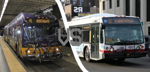
For the past two weeks, the American Planning Association has been running a Transit Bracket Challenge, pitting the largest transit agencies in the U.S. against each other in a popularity contest. King County Metro has so far quashed its competition, namely San Francisco’s Muni and the Maryland Transit Administration, leaving us as the sole West Coast representative.
Metro’s winning form has seemingly come teetering to a crawl and is in danger of halting entirely, thanks to its semifinal opponent: the Chicago Transit Authority.
As of writing (near midnight), Metro sits at 44.4%, while Chicago is pulling in 55.6%. Over 17,600 people have already voted in the Metro-CTA matchup, which is more than double the tally for the cross-town MTA-NJ Transit fixture in the other semifinal.
While Metro may not have the history and prestige found in each wooden tie and platform board on the ‘L’, we do punch above our weight in terms of bus ridership. Average weekday ridership on CTA buses is around 765,000, for a metro area of 9.5 million, while Metro carries 402,000 in a metro area half the size of Chicagoland.
And while they may have beat us to the punch in introducing electric battery buses, we’ve still got our reliable old trolleybus system to fall back on while we catch up in battery bus deployment. Our buses are also more frequent, more reliable, and are as busy as it gets in terms of American transit. Plus, we have a dog that regularly rides by herself.
You can vote here. The poll closes on Sunday and you can vote multiple times from multiple devices. The final round starts on Monday and will conclude on Sunday, June 9. The winning agency earns bragging rights at inter-city conferences, while voters can exercise their civic pride in time for the start of Ride Transit Month.
Voted! Thanks Bruce!!
Oh man, tough competition. One of the greatest bands of all time named themselves after them — how can you beat that?
Can you tell me please don’t tell me
It really doesn’t matter anyhow …
“Average weekday ridership on CTA buses is around 765,000, for a metro area of 9.5 million, while Metro carries 402,000 in a metro area half the size of Chicagoland.”
CTA buses are packed, run every ten minutes daytime, have half-hourly night owls spaced a mile apart, and make all the parks more accessible than Metro does. So they’re better in almost every way. The negatives are they’re uniformly bogged down in traffic and their stop announcements are really loud,. But at least the announcements are only one word like “Cicero” or “Damon”.
The ridership comparison sounds like applies and oranges. Chicagoland includes the suburbs, but CTA is a city-only agency with only minor forays into adjacent suburbs. There’s nothing comparable to Bellevue/Redmond or south King County or express routes from P&Rs in CTA.
In 2018 per PSRC, Central Puget Sound (65.0) had the same annual transit ridership per capita as Chicagoland (66.2).
The city of Chicago has half a million more people than King County in an area that’s slightly larger than urbanized King County.
Suburban Chicago outside the CTA, aside from the Metra rail system, has very poor transit service compared to central Puget Sound and is much more sprawled.
“The city of Chicago has half a million more people than King County in an area that’s slightly larger than urbanized King County.”
What? The city of Chicago geographically doesn’t seem any larger than Seattle. The south side seems to be as long as Rainier Valley and the north side as long as central and north Seattle at most, and taking the Diversey or Lawrence buses from Clark Street to the Blue Line doesn’t seem much longer than U Village to Ballard. So how can it be as large as Shoreline to Federal Way?
I checked the actual land area and my original description of “slightly larger” was a gross understatement. City of Chicago is 227 square miles. King County UGA, not including islands like Snoqualmie and Duvall, is 434 sq mi. The CTA itself serves an area of 309 sq mi.
“how can it be as large as Shoreline to Federal Way?”
A straight line measurement down Western from Howard (Chicago’s border with Evanston) in the north down to 138th St, the southernmost numbered street in the city of Chicago, is 26 miles. A straight line from Aurora Village to the border with Fife is 36 miles. If you include Evanston, which is primarily served by CTA buses and trains, add another 4 miles north.
How is NJ Transit slaughtering NYC MTA at the polls?
I saw “Newark” and the train looked like the Hudson-Bergen light rail, so I didn’t think about PATH and the regional trains statewide. But even with those, and even though PATH is impressively full late evening and runs 24 hours, it’s still nothing compared to the NYC subway and buses where you can live a lot more places and have frequent transit around the clock.
Never mind, that’s the opposite of what you meant. I evaluated NJT worse than it was, but you’re saying people are rating it phenomenally better. It could come back to state loyalty, or New Yorkers not knowing about the poll. or people wanting to stick it to New York, or people imagining New York’s transit in the 1970s, or New Yorkers wanting to send a message about the recent deterioration of service.
The NYCTA subway has a number of issues, including a lot of slow sections of track.
Opportunistic plug for ranked choice voting:
If this vote were a more serious data exercise, the vote designers would have allowed voters to simply rank the agencies instead of having a randomized playoff.
If we can’t even grasp meaningful vote systems, we won’t survive to become Kardeshev Type I.
I’m torn because I was born and raised on Routes 43-48 (Seattle) Now I call Chicago/Oak Park home for 10yrs using the “L” nonstop.
I also used to live in Seattle and currently live in Chicago. I will say that Chicago buses feel much slower than Seattle buses. One reason for this is the heavy traffic on major streets in Chicago (all of them feel like N 45th St in Seattle). The other reason is that bus stops in Chicago are spaced one block apart from each other, while Seattle bus stops are not quite as closely spaced (at least on some routes). Chicago buses are much more frequent than Seattle buses, but Seattle has improved greatly in the past decade, and I’m sure it will continue to improve. I want to say that the CTA wins for now, but I’m also somewhat torn because KCM feels faster and has been improving.
“I will say that Chicago buses feel much slower than Seattle buses. One reason for this is the heavy traffic on major streets in Chicago (all of them feel like N 45th St in Seattle).”
Yes, that’s what I was trying to articulate. A serious case of missing transit lanes. Although I wouldn’t say it’s as bad as 45th. It’s more like Aurora or 15th Ave W at rush hour, only all day.
One thing I noticed in Chicago is that some people drive from one el station to another, even though they know there’s a train practically door-to-door because they ride it sometimes. In San Francisco too I’ve seen people drive between two BART stations to go to church. That doesn’t happen nearly as much in New York or London. Suburbanites drive into Manhattan evenings and weekends, but it’s hard to imagine someone driving from one part of Mahattan to another, or from Queens or Brooklyn to Manhattan. Maybe it’s because New York and London are so congested and have been so for over a century.
“bus stops in Chicago are spaced one block apart from each other”
I didn’t feel that and I’m sensitive to close stop spacing. I think the Chicago stops are at every arterial, whereas Metro sometimes has two of them between arterials. NE 65th Street has stops every two blocks even though the arterials are ten blocks apart. There used to be a lot more of those before Metro’s stop diets. And MAX stops every other block downtown on the original east-west track. And our beloved SLU streetcar does this.
I didn’t feel that on Chicago’s buses; I was just annoyed that they were always stuck in traffic. I usually took the el because of this, but I sometimes took the buses for variety.
@Mike Orr Not trying to argue with you, but I live in Chicago (Hyde Park to be specific) and the stops are about 1/8 of a mile apart, depending on the route. You might be thinking about the J or X routes (J14, X9, X49), which do have stops at every arterial. Arterials in Chicago outside of Downtown are usually spaced half a mile apart, except in Lincoln Park and Lakeview where they are 1/4 of a mile apart. However, local buses often skip the non-arterial stops because more people tend to use the arterial stops (at least that’s what I’ve noticed when I ride the bus). I have to ask, where in Chicago did you stay and which bus routes did you take?
The lack of transit lanes in Chicago often has to do with the fact that many major streets are only two lanes with parking on both sides. A while ago the city was discussing adding bus lanes on Ashland and Western, both of which are four lanes wide. The transit lanes in Downtown seem to work well, and I would definitely appreciate more transit lanes throughout the city.
The thing that distinguishes the two agency is that Chicago’s includes both bus and rail while KCMetro is just bus (assuming that the Metro-operated rail is perceived as Sound Transit).
Having a bus+rail system really makes the bus part of the trip easier. The radial shape of the CTA rail system pretty much puts a station within two miles or less. Bus speeds are less important in that situation.
We will essentially be approaching this by 2035 (minus the missing Central District and Aurora lines).
Finally, as awesome as the elevated rail loop is in Downtown Chicago, there have been calls for to have a circumferential line for decades. It is not very convenient to ride several miles Downtown and then ride back out a few miles. — on crowded trains! The isthmus shape of Seattle reduces that situation — although there is interest in better east-west (Ballard-UW) and north-south (Metro 8) connectivity in addition to ST3.
I spent most of my time around Belmont & Clark and usually stay at the hostel near Fullerton & Clark, although the first time I stayed in a basement apartment in a row house near the north end of the Brown Line (where it has surface crossings), another time in a hotel in Rosemont, and the last time at the Day’s Inn on Diversey. So I mostly rode the Clark bus, the Diversey and Lawrence buses, and the Red, Brown, and Blue Lines. I haven’t ridden any of the express routes. I also visited a friend in Jefferson Park, and went south on the Red Line and found a university whose name I don’t remember, and walked quite a way on Michigan Street to see the Miracle Mile and found an underground street. I remember being at Howard once, and another time I tried to go north to Evanston but it was already taking an hour so I turned around at Loyola, so that may be where my perception of the north end is shorter than it is, if I’m underestimating the distance between the Loop and Belmont and how much is north of Lawrence. How far are those distances?
And what is that underground street? It looks like it has regular intersections and cross streets, where do they go to? I don’t think I saw any businesses down there.
Or Logan Square? I transferred at Jefferson Park but maybe my friend’s house was at Logan Square, because I remember asking whether to take the Diversey bus or to take the Red Line down to the Loop and back on the Blue Line, and he said he usually takes the L because the buses are so slow, but I don’t remember which I did. When I stayed at Rosemont there was a lot of transferring between the Blue Line and east-west buses and they all blur together.
If your definition of The Loop has a north border at the river, the distance to Belmont is about 4 miles. There is 3.5 miles between Lawrence and Howard, the city’s northern border.
Downtown Chicago has multiple layers, so I think you’re talking about Lower Michigan. There are many underground streets, which many people use to bypass the traffic on the main streets.
The 76 Diversey bus runs through Logan Square. Rosemont is in a suburb, and there are many Pace buses going from the station to nearby suburbs. Jefferson Park is in the city, and there are many east-west buses there.
The Red Line passes by three universities: Loyola University Chicago, DePaul University, and Illinois Institute of Technology. LUC is by the Loyola stop (hence the stop name), DePaul is by Fullerton, and IIT is by 35th.
In that style of election Chicago will win every time ;-)
“In that style of election Chicago will win every time ;-)”
Do you really believe that every vote counted in Washington’s 2004 gubernatorial manual recount was filled out by a unique voter?
Here’s this for New Jersey Transit. I had a friend who lived somewhere around Red Bank. There’s a regional train from from Manhattan to Red Bank running every 60-90 minutes, which I took a couple times. My friend lives somewhere in a middle-class neighborhood where he says, “There are no buses around here.” He has to drive half an hour to a mall just to get a bus to Red Bank, where we met for dinner and where he can get the train to Manhattan.
Good Lord, the margin for Chicago is even better now- they have 67.4% of the vote to Seattle’s 32.6% of the vote.
Interesting timing on this poll. We just had friends from Chicago (Lakeview neighborhood) visiting us over the weekend. These are 30+ year friends who we see every couple of years, either when they come out this way or we visit them in Chicago. They are heavy transit users in their home city (they live carless but use Uber occasionally) and have used transit here in our area to get around our city center and to visit different parts of Seattle. So I think they have a fair sense of how well (or not) our bus system operates. Likewise, we ourselves have used transit often enough when out in Chicago to get a sense of how well the CTA’s bus system works, though admittedly we have taken the train far more often. The votes among the four of us were three for the CTA and one for Metro. The sole Metro vote was by my spouse but I think his vote is a bit biased (native Seattleite….lol).
Well, it appears we just got our votes cast in the nick of time. The finalists have been announced: CTA vs NJ Transit!