Community Transit has begun a public beta test of a new trip planning interface on its website using the OpenTripPlanner system. The trip planning website will be able to provide real-time departure information and service alerts for Community Transit routes and integrate with other regional agencies, including Everett Transit, Metro, and Sound Transit, in a manner similar to the current trip planner.
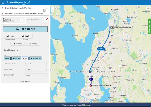
The beta trip planner uses a modern map interface similar to Google Maps, putting destinations first and collapsing time and mode options. The current trip planner puts all of these options at equal importance on the launch screen, which isn’t as intuitive for users. The current interface also requires an extra screen for most addresses to confirm which city they are in, while the beta interface uses a simple drop-down box for suggestions as the user types.
The beta trip planner is also able to mix modes, adding a personal bike or use of a park-and-ride for extra flexibility. This comes in handy for some trips that would otherwise have an extremely short or slow bus connection to reach a high-frequency hub, or is out of range for buses but is in easy driving distance to a park-and-ride lot. As a bonus, the bicycling and walking options also include an estimate of calories burned for those who need some extra encouragement to add an active segment to their commute.

The trip planner is also able to use real-time arrivals data from Community Transit’s in-house BusFinder tracker to better plan around delays and other interruptions to service. The beta trip planner would also be compatible with a potential future mobile app (though one would hope that a regional trip-planner would be included in an ORCA NextGen app) and integrate other edge cases like private bike and scooter rental services.
The beta trip planner uses OpenTripPlanner (OTP), an open-source trip planning framework that has been in development for over a decade. It uses General Transit Feed Specification (GTFS) data displayed over OpenStreetMap, an open-source mapping website that is edited by users in a manner similar to Wikipedia. OTP was funded with a seed grant from TriMet and has since been adopted by the agency, as well as SEPTA in Philadelphia, Ruter in Oslo, and HSL in Helsinki, among others.
The beta trip planner is available to try out on desktop and mobile at newtripplanner.communitytransit.org, where comments can also be left at the feedback tab. The current trip planner also remains available for those who want to try a straight comparison between results.
What’s the point in agencies rolling their own trip planner these days vs. just telling it’s customers to use Google Maps?
There’s no guarantee that Google Maps will continue to provide updated information. They are notoriously slow to update around major service changes, and seeing as CT has a few big ones coming soon I would rather use the in-house planner. As a bonus, a separate version of the planner can be made during the lead-up to the service change so users can see their modified commutes (along with the modified schedules, which CT already posts weeks ahead of time).
Bruce,
Since you mention the freshness issue: do you know how the other commercial providers compare in terms of update speed relative to Google when events such as major service changes take place? Just wondering.
Thanks a lot in advance!
What’s the point in doing anything other than giving all user data to Google?
For a less snarky response: relying on Open Trip Planner does not seem particularly bad. OTP is described very well in the article so I will not try to rewrite it (more poorly) here. My understanding is that OTP (and the more general OSM environment) is becoming a reasonable open-source alternative, so it is not surprising that some entities may find it both cheaper in the short term (vs. paying API money to a company like Google) and more politically palatable (in terms of aligning with non-profit entity goals, which I assume CT is as a county entity). There may also be legal implications in a county-level entity like CT directing (potential) customers to a commercial providers with which there is no explicit contract in place; I do not know of such things but perhaps some of the legal experts can comment.
Having said that, there is certainly a trade-off involved (with competing factors including data quality/freshness, ease of integration, long term maintenance load, and upfront/maintenance cost) and the various providers (including both Google and OSM) will fall in slightly different places on that spectrum. Someone from CT could perhaps provide additional feedback on how the decision was reached.
One more point on using Google APIs for route planning: as I recall, One Bus Away was relying on those APIs at some point, but then due to API changes and/or pricing changes, the feature was dropped. I will not editorialize on how how that might translate to similar features being relied upon by other entities; it just seems like an interesting anecdote.
As long as there’s a human in the loop to actually talk to people and keep them informed when Google screws up.
They help keep people from driving onto the Edmonds ferry dock, for instance.
CT is adamant about using in-house products such as its Trip PLanner and MyBusFinder. The unfortunate downside is that, like any government agency, it’s years behind user trends. Customers are now used to using Google, OneBusAway, MoovIt, etc. CT should simply give up because, though well intentioned, the internal culture is just too slow to adapt to merging customer trends and should invest in strengthening ties with Google and OBA.
Old saying, but credible: “In order to successfully ask a question, you must already know most of the answer.” Can’t help it. This is the travel-planning version of either automatic cars or punishment cameras. Whichever’s worse.
Solution, same as for the plate-taping wars. Train, and pay skilled, talented, thoroughly knowledgeable people to answer questions and give explanations. Whose familiarity will let them tell you which stop you really, really don’t want to get off at. Well, maybe name a better one.
Wouldn’t surprise me if somebody already has a website.
Mark Dublin
I just played around with this beta version for a few minutes to check out some of the options. I wish CT would stop comingling the CT routes with the ST routes that they operate. (I believe they do the same thing in TripPlanner.) Just identify the route as an ST bus, since that’s what the rider is going to see pull up.
For years now I’ve suggested that people who ask me transit questions start participating in Sound Transit Blog, essentially (which doesn’t always mean COVID) trading experience of their own for information. Bruce, Martin, Brent, Oran and the rest…they all say Thanks.
Mark Dublin
I do not take CT for my trips. I tried the trip planner anyway. When I try programs such as this I always use the 3 of my most frequent transit trips. That way I can see if the program will work for me. I know the fastest and most convenient way to get from point A to point B on these 3 trips. I know what routes to take at at least 3 times a day to get to them and back. This is a combination of time and proximity. This particular planner only gives me a correct answer on 1 of those trips. But maybe I do not know how to use it. Plus, I live in Seattle. My routes do not include CT. But based on 20 minutes of playing around, it is not for me.
The Trip Planner is valid for all three Seattle-area counties. Try it for your own commute and/or places you often frequent on transit – no matter if it’s all Metro. You should send your feedback cuz CT needs all the customer input it can get during these times. If no one speaks up, then they’ll think they have a great tool.
Thank you. I will.