(Part of a series highlighting high-performing transit routes in the Puget Sound region)

Metro 8 performs well at all times of the week, with its particular strength being the amount of rides it carries for its level of service. Its total ridership is eighth among Metro routes, with 4,828 rides per weekday, but it does that with fewer platform hours than anything above it on the list, which is the reason it performs so well on rides per platform hour. It places second in that metric among Metro routes on weekdays, carrying 34.7 rides per platform hour during peak periods and 32.3 daytime off-peak. That means a single 8 trip taking 45 minutes provides a ride to an average of 26 people. I was interested in what accounted for its success, so, as I did with RapidRide A, I went looking for answers. I took the light rail to Mt. Baker, where I hopped on the 8 heading north.
Riding the 8 on that weekday afternoon, it was interesting to me how much the 8 felt like two routes in one. The first section, which aligns north-south mainly on MLK Way, runs through the leafy pre-war neighborhoods of the Central District. The trip during this leg was fast and lightly boarded. With the exception of a clutch of people who boarded at the deviation to 23rd Avenue (near the excellent Communion restaurant), the bus was almost empty.
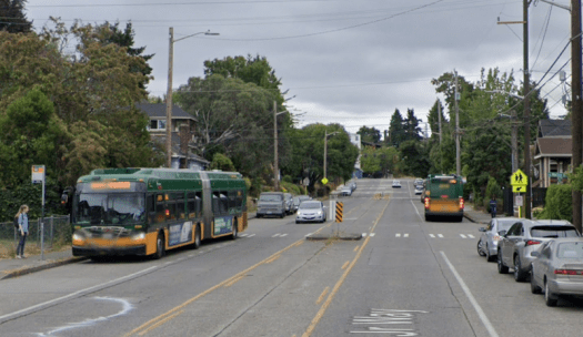
The second leg of the route was much busier. This is the section that runs east-west from Madison Valley to Uptown, ending a block from Climate Pledge Arena. Almost immediately after the bus turned west, a large group of people boarded outside an apartment complex. The bus was suddenly busy, and it remained so through the end of my trip, despite big turnovers of people at the major stops. As we passed through Capitol Hill and South Lake Union, people came and went so rapidly that it was hard to keep track. Finally, the bus stopped, and I realized (after everyone else had debarked) that this was the end of the line. I wandered around, bought a sandwich, and looked for a way to get home.


What makes the 8 successful on its productivity measures? It has the benefit of going through some very dense places of Seattle, plus serving points of interest like Seattle Center. But it is hardly unique in this regard. In fact, its performance (on total ridership, on rides per platform hour) is better than other routes that serve even denser areas, like Routes 2 and 10. Those routes have similar frequencies throughout the day to the 8, so frequency cannot explain it, either. The 8 does avoid deviations, except the one to 23rd Avenue. That counts in its favor, but that alone does not make a route a top performer.

Judging from how busy that east-west leg was, I would argue that the major, useful connections along its east-west leg account for its success. In less than three miles of travel, it makes connections to Link, RapidRides C, D, and E and the 40 and 48 bus lines. All of those are among King County’s busiest transit lines, and a rider on the 8 can access any corridor that they would like. Because it runs cardinally east-west and makes perpendicular connections with those lines, it is the most direct route to connect them. In this city where so many travel routes run north-south, it makes sense that a route providing a useful connection with all of them would be highly productive. I believe that is what we have here.
There are other ways to conceptualize the 8. It takes an indirect route between Mt. Baker and Uptown, meaning it is not good for end-to-end travel. But it does connect the midpoints of the route to either end, directly. You could think of the 8 as two routes, heading west and south from Madison Valley, that just happen to be through-routed with each other for efficiency’s sake. The 8 also is a part of what Jarrett Walker calls a “spiderweb grid,” playing the role of a circumferential by joining routes radiating from Downtown on two sides. One of the interesting things about the study of transit is there are so many ways to think about how a single line fits into a larger network. When you consider all the possible connections and routes a person could take, the possibilities are almost limitless.
Overall, the 8 suggests the importance of transfers in the success of a transit line. It doesn’t serve downtown. It does not have a clear niche to serve a particular type of travel pattern. Yet because of the way it connects to other routes, it becomes significant and useful enough to count among Metro’s best-performing services. There is a larger lesson to this observation: after all, even though this series is focused on high-performing lines, it ultimately does not matter where a single line can get you, but where the whole transit network can get you – and how quickly. Each individual line is subordinate to its position in a greater network, a greater ecosystem. By making so many quality connections to other routes, the 8 points to the importance of all the other routes that enable it to succeed.

I find this a really interesting analysis of the route and it’s details. It does seem though that metro has moved the goalposts to make thev8 look better than it is. I’d rather see it carry less people and operate on tiime.
honestly metro seems to think if they invent new stats they can olignore that aspect. I live in Belltown but I’d never take the 8 anywhere because at the end of the day it’s still just the “L8″…
The 8 started in the 1990s or 2000s. Before that there was no Denny Way route. I used to wish there were so I wouldn’t have to go the long way via downtown. My friend in north Lynnwood grew up in the Summit apartments and attended Queen Anne High School in the 70s. She walked to it rather than doing the long bus trek via downtown.
The 8 was initially only went east to 15th and had limited hours. It was so popular that it was expanded again and again, both in terms of span, frequency, and extent. The 43 (now 43/44) and 48 (now 48/45) were created before it. Metro was reluctant to create the 48 in the 70s, thinking it wouldn’t get enough ridership. But it did. The 31 and 32 on N 40th Street were later. All these crosstown routes exceeded expectations and were repeatedly expanded.
The Northgate Way/105th corridor has been served by different routes (41, 75, now 40). My impression is it doesn’t get as much ridership as the ones further south. But it still contributes to a grid network.
Yes, crosstown service has improved. Route 8 was first implemented in about 1995. A community group asked for it. Metro held a constrained process. The hours were taken from the existing network (e.g., routes 2, 13, and 10 were reduced?). It began as a 30-minute headway service. The east terminal was on 16th Avenue East. Locke made fiscal changes to fund more service. In June 1997, Route 8 was considered for a frequency boost by the sounding board. Instead, the ordinance included extending Route 8 to Jackson Square via Madison Street and MLK. During the ordinance process, after the council a pot of unexpended transit capital funds, all 13 members got to spend some service hours. Pelz asked for Route 8 to be extended south to South Walden Street. Over time, Route 8 frequency was improved. During the SDOT Mercer Street projects, Denny Way congestion was very bad and reliability poor. In 2009, it was extended to Rainier Beach via MLK. In March 2016, its headway was reduced. In fall 2016, it was truncated at Mt. Baker. SDOT and Metro had a project to improve flow. This year, SLU congestion is back and reliability is bad again. One obvious issue is the queue behind the I-5 southbound ramp from Yale Avenue. The traffic queue backs up well beyond the transit lane. Denny Way is jammed eastbound.
Route 8 is not proposed for change is the G Line process.
“Locke made fiscal changes to fund more service”
For those who weren’t here then, Gary Locke was King County executive 1994-1997, and Washington governor 1997-2005.
Eddie (or Mike), has the route always had that jog east and west just south of Garfield? Is that to connect with the Jackson Square area around 23rd? Do either of you happen to know the rationale for the deviation?
I think that’s the right timeline for the route’s creation btw. I used to live in the CD in the late 80s and early 90s and the route didn’t exist then.
The June 1997 version was going to use Jackson Square as the terminal. Connections with Jackson Square was part of the rationale. When the council extended it, the deviation was retained. Perhaps to serve the retail area; perhaps for a transfer point with Route 48. The loop serves Garfield and the library. There was still a variant that stopped at 16th Avenue East. In the teens, funds were spent on the turns at 23rd Avenue and Yesler Way.
I have CD friends who use Link to MBTC and then take routes 8 or 48 north, which ever comes first.
“One obvious issue is the queue behind the I-5 southbound ramp from Yale Avenue.”
That part of the problem has already been fixed. The eastbound 8 now has a bus lane between Fairview and Stewart, which has made a huge difference. Unfortunately, the rest of the route is still as congested as ever.
asdf2: please go out and look in the p.m. peak; the outside eastbound lane of Denny is backed up to Westlake Avenue North. The buses have difficulty serving the stops farside Westlake and nearside Fairview and getting to the short bus lane. Traffic overwhelms it.
The buses have difficulty serving the stops farside Westlake and nearside Fairview and getting to the short bus lane. Traffic overwhelms it.
Yeah, I’ve ridden it, and seen it from the Denny stop. It is quite striking. The bus just crawls, barely moving, inch by inch until it finally gets into that bus lane. Then it moves quite quickly to Denny. We need bus or BAT lanes all along Denny.
Route 8 is also one of the few routes that connect Capitol Hill with SE Seattle. It even used to run on MLK further south a decade ago — but Route 106 does that today.
I think it’s best feature is the “L” shape of the route. That shape means that it crosses many major routes, enabling a rider to reach many places directly or with just one transfer. It even has two points where Link transfers are possible.
I disagree. The “L” is one of its few weaknesses. It is making a trip that should just be a transfer. The 8 is very successful in large part because it has no competition. It is the only east-west bus in the area*. The “L” creates that competition. For example, if you are trying to get from MLK & Union to Uptown, you can take the 2 or the 8. If you are at 23rd & Cherry headed to the Seattle Center, the 3 works about as well as the 8. The “L” is why it doesn’t work from end to end.
In contrast, consider what would happen if the 8 was sent to Madison Park (taking over the 11). Now every trip from bus stop to bus stop makes sense. There would definitely be people taking it end to end. It would go east-west the entire way. It would still cross plenty of routes (that are going north-south, or in the case of the G, diagonal). It would be shorter, and run through areas that have a lot less density, but it would save a lot of money in the process. That money could be put into making buses like the 48 run more frequently.
* Hard to define that area. Some have referred to Capitol Hill and Uptown as “downtown”, but that seems a bit of stretch. It could be considered our “central urban core”. It is the largest contiguous high-density area in the state. There are spikes of density (in places like the U-District and Downtown Bellevue) but they don’t spread that far. For this area, there is no real competition for that east-west route from MLK & Madison to Queen Anne Avenue & Mercer. The 2 is the closest, and it is quite a bit farther south. The 2 also competes with similar buses (like the 12) along the way, while the 8 just doesn’t have any competition along that east-west path. That only occurs in the north/south part of the 8, when it competes with the 48.
“Some have referred to Capitol Hill and Uptown as “downtown”, but that seems a bit of stretch.”
The city has recently started positioning the adjacent neighborhoods as part of downtown. So between Valley and Weller, and east to Broadway or 12th. In the mid 2000s it called this area “Center City” but now it seems to have settled on “downtown”.
This conveniently makes it appear that downtown has more housing and is safer without actually changing anything. It also means things like the Pike-Pine complete street and similar projects in SLU are all within downtown.
To me downtown is west of I-5 between Yesler and Stewart or Yesler and Denny (it’s ambiguous).
I think it’s important to mention the pending Route 8 reroute for East Link (Judkins Park station).
https://kingcounty.gov/~/media/depts/metro/programs-projects/link-connections/east-link/route-maps/008.pdf
I think that the new connection will attract riders to the south leg of the route as it will be a new high activity stop for Route 8 that doesn’t exist today. The 23rd entrance to the station is going to be very convenient (compared to the Rainier entrance). It may even pull riders from those waiting for Routes 14 and 27 because it will only take four minutes on average to ride from 23rd and Jackson to the Judkins Park 23rd entrance and a rider will have either Route 8 or Route 48 to use for that trip leg. Route 27 only runs every 30 minutes for much of the day.
Interesting that you point out that the 8 is not a route that you would necessarily want to or need to ride end to end, but there are many use cases for shorter segments along the line. The same can be said for the streetcar system, especially a completed streetcar line using 1st Ave. through downtown. Nobody would ride the streetcar from SLU to Capitol Hill. The 8, slow and unreliable as it is, would of course be better. This is not to say that a bus couldn’t necessarily do the same, as clearly in the case of the 8, a single bus line can be an absolute workhorse! I’m just pointing out that some very useful routes are not routes that it makes sense to ride end to end. Except for the occasional transit blog post, of course.
This gets into the “Geometry of Success” as Jarrett Walker puts it (https://humantransit.org/2013/08/translink-high-and-low-performing-routes.html). “All other things being equal, long, straight routes perform better than short, squiggly and looping ones.”
The 8 is not long and straight, but it a lot longer and straighter than the proposed streetcar. Another way to think of it is trip pairs (a trip from one bus stop to another). Ideally every trip is reasonable. In both cases, the routes fail the test for some trips. It is just that the proposed streetcar (which basically forms a loop) fails in a lot more of them.
The biggest difference is that it is fairly easy to change the 8. We could fix its flaws overnight. OK, we would need the usual outreach, changing of bus stops, etc., but it still wouldn’t be that difficult. In contrast, the streetcar is essentially permanent. It costs too much to move it.
A little off-topic, but I’m curious what Jarrett Walker would think of a transit network like the one in Bucharest. This is not the complete map, I believe this is only their bus system (they also have trams, and a metro, and trolleys)
https://bucharestmap360.com/img/0/bucharest-bus-map.jpg
For an example of one of their streetcar/tram line:
https://info.stbsa.ro/traseu/63
And here’s a not atypical trolley line:
https://info.stbsa.ro/traseu/76
As a follow-up, I also found this one streetcar line which maybe takes the cake:
https://info.stbsa.ro/traseu/47
Three of the 11 routes in Jartett’s diagram are long L-shapp of Ed routes like Route 8.
The low performing routes are much shorter and have no long L-shaped routes.
Cities like Bucharest have challenging street grids and trams that both evolved over time. I’m sure any planner would look at some of those routes and wish they were straighter. You shouldn’t be able to get off the tram/bus, walk a little bit, wait, and get right back on the same tram/bus. You can do that with our streetcar, and if it is extended, do that in various places. It is just not a good system.
@Al — L shaped routes are second only to I shaped routes. In contrast, the streetcar is a U, about as bad as you can get. The weakness of the 8 has more to do with the nature of that L. It is an awkward turn. The bus goes east on Thomas, merges with Madison to go northeast, then takes a hairpin turn to head south on MLK. This is less than ideal (and not really an L, although it is close). But things get a lot worse from there. The 8 competes with the 48. They are very close together, and sometimes overlap. But riders have to choose one or the other for many trips. The craziest is the section where the 4 runs in between the two. It is only a small segment, but consider this spot right here: https://goo.gl/maps/qfZ1sUqr5Fu42qFC8. You’ve got three buses, all heading north, and all on different bus stops. If you are trying to go to say, Garfield from there, you have to choose. They all work, but three different bus stops (https://goo.gl/maps/qsr8bVzFvgsdnqca9). Even without the 4, it is crazy how often you have to choose between the 8 and 48 even though they aren’t that far away. Meanwhile, if you are just trying to go north on the 8, it can’t seem to make up its mind — it keeps going back and forth, first on 23rd, then MLK, then 23rd again. The buses should just be consolidated to 23rd. You could favor the “L” of the 8, over the straight shot of the 48, but I don’t see why you would that. You could double up the routes, but that seems wasteful as well. What the area needs more than anything is not more routes, but better headways. Holy cow, they are talking about 20 minute service on several of the core routes. The 8 and 48 only run every 15 minutes. A lot of these buses should be running every 10 minutes (or better, like the 3/4 and G). You have to build a more efficient system, or it becomes garbage.
By the way, the 8 has another L, to get to Uptown, and I see no problem with that. It is at the end of the route, and really isn’t a detour. Likewise, if the 8 and 11 are combined, the bus still isn’t a completely straight shot. But it is about as straight as you can get. Every stop pair makes sense. There is no place where an alternative bus (or walking) is faster. The 48 would be the same way, if it wasn’t for Link (which happens to be at the beginning and end of the route). Otherwise it is a straight shot as well. The more grid-like the better.
The 8 (in yellow) and the 2 (in orange) both run through areas of high residential density. Both are strong routes, but the 8 has higher daily ridership and rides per platform hour.
I know I’m nitpicking here, but that was not the case prior to the pandemic. Personally I think the more recent numbers should be taken with a grain of salt. The network is still suffering from the pandemic. It is also a moving target. Ridership keeps growing, although the driver shortage is taking its toll. Personally, I put more weight in the pre-pandemic numbers for routes like these.
In 2019, the 2 and 8 were essentially the same in terms of ridership per hour. The 8 had slightly better peak performance, and the 2 had slightly better off-peak numbers. I’m sure that if you looked at the stop data, you could find segments of the various routes that perform much better than others. To me the big takeaway is that the 8 is in the same league as some of our most successful buses, despite not serving the central business district. It was actually third in terms of peak ridership-per-hour. Remember, I’m quoting numbers from before the pandemic. It is striking, really, that a bus that is known for being stuck in rush-hour traffic — and does not go to the CBD — got such outstanding numbers for peak ridership. According to the 2019 report the bus with the highest peak ridership was, surprisingly enough, the 44. The gold and bronze medals, as it were, for peak ridership-per-hour go to buses that don’t go the central business district. The obvious take-away is that grid routes are essential and productive. Even before the pandemic, not everyone was headed downtown.
With the 2 and the 3/4 both going mostly east-west (and then turning north) they create a grid of sorts. All of them perform very well, which again shows the strength of a grid.
The other thing that is interesting about both the 44 and 8 is that they have little competition. Buses like the 2 and 12 run very close (or on top of) other buses, for most of their route. But west of MLK & Madison, there is nothing like the 8. Riders aren’t making last second decisions as to whether to walk one way or another (based on One Bus Away). The 10 shares the same path, but only for a tiny segment. Like other buses in the area, it doesn’t head east, but angles towards downtown, ending there. West of I-5, the buses are largely perpendicular until the 8 itself goes to Uptown (which is only a tiny segment of the route). Like Capitol Hill, the other Uptown buses all head south, instead of east. That part of the 8 (from MLK & Madison to Uptown) is like no other.
The only place where the 8 has real competition is in the Central Area. It poaches some of the 48 rides, although in a few cases, riders can take either bus. It would be interesting to compare trips along that segment (south of Thomas). My guess is, the 8 and 48 basically weaken each other. I personally think the two routes are too close together, and they should be consolidated. I would send the 8 to Madison Park (replacing the 11) and put the savings into running the 48 more often. Trust the grid.
* The 44 barely edges out the RapidRide D in peak ridership per hour. To be fair, the A and B aren’t listed for some reason. It is unlikely the B had the best peak-hour numbers, but the A might have.
At the northern end of MLK there’s an extremely steep hill between the 48 and 8, so steep it has treads in the sidewalk. So the 48 is not an alternative for non-athletic people. That’s probably part of the reason why the 8 is still on MLK.
I will offer one use case for traveling on route 8 between Mt Baker Station and Capitol Hill Station: Social distance and masking.
When I have stepped on the train lately, I have more often than not found myself face-to-face with standing maskless riders, for a duration of multiple minutes. I try to find an open seat in the back, but those are usually already taken.
I might not find the open seat in the back on route 8 either, but the odds sound good based on this article. If I decide to stand, gravity becomes a very effective layer of PPE that is often not available on the train.
Just don’t try this pre-morning bell, or within an hour after afternoon bell.
In general, I see a quarter to half of bus riders wearing masks, and about three quarters of masks covering the nose. I do see some mask wearers on the train, now whole families. But they are a distinct minority and a much smaller share than the maskful bus riders.
It’s interesting that performance does not include schedule compliance. #8 is one of my local routes and the only practical intercept of the light rail form most of the Central District. I take it very often and it has extraordinarily poor schedule compliance, even for Metro. It is so bad that the L:ocal band Taco Cat wrote a song about it. Maybe it would get a little better if Metro considered schedule compliance as part of their performance metric, Sigh.
Imagine if route 8 terminated near Capitol Hill Station, with the SLU section as its own route.
Metro does include schedule adherence when analyzing routes. It is in a different part of the report. The “Rider Dashboard” (https://kingcounty.gov/depts/transportation/metro/about/accountability-center/rider-dashboard.aspx) lists it as well.
Imagine if route 8 terminated near Capitol Hill Station, with the SLU section as its own route.
A lot of people would get off the bus, and back on the other one. A lot of people use that stop, but that is true for all the stops along there. Granted, I’m looking at the data from before Northgate Link. I’m sure more riders use the bus to get to Link now. But the stop didn’t dominate — far from it. Things are fairly spread out, with most of the ridership coming from the east-west section. The number of boardings starts dropping off as the bus heads past the station, but the number of people getting off the bus doesn’t. For an eastbound bus (starting in Uptown) more people get off the bus before the station than at the station. Likewise, more people get off the bus after the station (but before the bus turns and heads south) than at the station. 15th & John has almost as many riders getting off the bus than Broadway & John (Link).
Meanwhile, there are a fair amount of people who ride it past the turn. But way more just ride it east-west. I’ve been looking at from that perspective:
Exclusively east-west trips: 2,550
Exclusively north-south trips: 350
Rides involving a turn: 850
(These are pre-pandemic number, one direction.)
It is interesting to compare the 48 and 8 numbers for what is essentially a shared corridor (23rd/MLK south of John).
Riders of the 8 exclusively south of John: 350
Riders of the 48 exclusively south of John: 900
Riders of the 8 involving a turn: 850
Riders of the 48 going past John: 1,200
This suggests two approaches:
1) Keep the 8 as is, but move it to 23rd.
2) Send the 8 to Madison Park, and improve the 48.
I prefer the latter. There are people who make the turn, but they could do so with a transfer. Lots of people are making that turn, but a lot more are just heading straight. If you are headed to Link, there are other options. If you are headed north (e. g. to Northgate) then you can use UW Station. If you are headed south on Link, you can use Mount Baker Station. In between, you are better off with buses that go downtown directly. The problem is again congestion. The 48 needs to be able to move quickly and frequently. The city needs to fix the mess around the bridge. The bus shouldn’t be stuck in traffic when the bridge goes up, or there is rush-hour congestion.
15th is the top of the hill. A significant number of people get off there for that reason, including me.
Yeah, it is also where the hospital is (used to be Group Health, now Kaiser-Permanente). That has always been a busy area.
Amazing how much ridership you can get when you offer crosstown routes near the city center that bypass the long slog (with a transfer) through downtown itself.
Now, when will Metro do the same down Boren as they did with Denny and run a bus between Seattle Center/South Lake Union and First Hill? It is mind-boggling that in 2023, two neighborhoods this big, this close to the city center, connected in a straight line by a major road, do not have an all-day bus route that runs between them.
The – I think I’m remembering the number correctly – 63 used to run from Northgate, down 5th Ave through Maple Leaf, on I-5 to SLU, and then up to First Hill. Unfortunately, it was always a rush-hour only route, and was also a pandemic casualty. Anecdotally, it also seemed to be a relatively decent performer. I’d love to see it make a comeback.
Steveb, yes, Route 63 was a one-way peak-only service oriented to SLU and First Hill; it ran between March 2016 and October 2021. It was similar to routes 309 and 64. Before U Link, Routes 66-67 used to serve 5th Avenue NE; Route 66 was deleted; Route 67 was shifted to Roosevelt Way NE. The old pattern was odd; the denser Mapleleaf corridor had Route 68 with long headway and the single family corridors had more service, routes 66 and 67 on 5th Avenue NE and routes 73 and 77 on 15th Avenue NE.
Yeah, that would really be nice. The bus would likely be stuck in traffic (just like the 8) but it would still get plenty of riders. It really should be added with the help of SDOT, so it can go in with bus lanes (making it both faster and cheaper to operate). I would add it as an extension to the 106.
Recently, Ryan Packer has been documenting the extreme delays experienced by the 8. I’m only familiar with the E/W stretch, and it seems like it’s long past time for there to be curbside bus lanes along much of Denny.
I know that I would visit Capitol Hill much more frequently from Ballard if the 8 were a faster connection from the D at Seattle Center. The schedule might say it takes “only” ~40 mins, but the 8 is, as other have said, always late, and it seems like traffic on 4-lane Denny is the main cause.
Anecdote:
I was driving from a site visit and wading through traffic westbound on Denny a couple weeks ago. Making my way past Denny Park, an ambulance struggled to get past mid-day bumper-bumper traffic.
Evidently, bus lanes on Denny would not only benefit the 8, but allow for more effective emergency response.
Between the rise of SLU and covid, the 8 was crushloaded in the PM peak from at least Westlake to Broadway, even with the tech companies paying for extra bus runs. Denny Way was gridlocked from Aurora to the I-5 entrance, so buses were some ten minutes late. You could see a bus stuck in traffic two blocks away. This happened every weekday. This happens at several freeway entrances like 45th and Northgate Way and Montlake Blvd, but Denny Way and Montlake Blvd seem to be the worst. Still, people waited for a crushloaded bus to avoid walking up the hill. I did that after shopping at Whole Foods sometimes.
During the lockdowns the crowd naturally melted away, and SDOT did something about queue jumps to speed up the bus. After that things were better for a while. Now I hear the slowdowns have somewhat returned, so the SDOT solution may not have been enough. I haven’t ridden the 8 in that area since the lockdowns so I can’t say.
Things have definitely got worse for the 8, as they have for a lot of buses: https://kingcounty.gov/depts/transportation/metro/about/accountability-center/rider-dashboard.aspx. This just measures what percentage of the buses are five minutes late (or later). It doesn’t measure how late they actually are (a bus that is ten minutes late is treated the same as one five minutes late). I’ve heard some really bad stories with the 8. This just shows how important it is to make that corridor faster for buses. If you can get really high ridership per mile, despite being really slow, imagine what would happen if it was fast. I feel like a metric that involved average speed, reliability, and ridership per mile would give us an idea of what areas should have the biggest investment. For example, the RapidRide E is quite fast and reliable compared to most buses. So while its ridership per mile is pretty good, making it faster wouldn’t have the same impact as compared to say, the 3/4 corridor, where ridership is higher per mile, and the buses are a lot slower.
Part of the problem is that SDOT needs to add bus lanes. They did some work on Denny, and improved things, but they need to do more. You also have people who break the law, and make things worse for everyone (but themselves). It was nice reading about Seattle increasing the number of cameras: https://kingcounty.gov/depts/transportation/metro/about/accountability-center/rider-dashboard.aspx. Looks like they have a “Don’t block the box” camera for Denny being added (but not a BAT lane camera).
I agree Nathan. Denny should add BAT lanes on both sides of the street. This is the type of change that would have seemed radical not too long ago, but we are in the process of doing the same thing on Rainier Avenue and Westlake, while considering reducing Aurora to one lane each direction. Aurora! I’m not saying that will happen, but the fact that we are seriously considering it is huge, and shows that the tide has turned in Seattle. I’ve spoken with the new SDOT chief, and just like the last one, he is striking how strongly he felt about these issues. He was chatting with a guy who was studying traffic engineering and he joked “you’re hired!”. It is clear he “gets it”. This is the type of talk I would expect to hear from McGinn, but instead it is coming from Harrell’s office.
Even with that said, areas need to be studied. There are cases where reducing the number of lanes can cause backups, and those backups can hurt other buses. In this case, though, I don’t think it is a big problem. There are only two big east-west streets: Denny and Mercer. Sending more cars to Mercer really doesn’t matter. Buses only go on Mercer west of 1st Avenue North. If Mercer becomes clogged, they could add a few queue jumps and do the same thing there. There is no need to worry about anything east of there (all the way to the freeway). We have to make sure the Queen Anne Avenue/1st Avenue North couplet has BAT/bus lanes, and for the most part, it does. One of the key elements of driving is that it is very trivial to adapt (especially with online maps telling you the fastest way to get anywhere). People will quickly switch to using Mercer instead of Roy, which means at most we would need to add just a bit of bus lanes on Mercer as well, which looks fairly easy.
This looks a lot like the 40 project. A lot of benefit, without that much cost. It will take a while to go through the user-feedback process, but it still shouldn’t take that long. Unlike the 40, I wouldn’t even worry about the full corridor, or the bus stops themselves — just where to add BAT/bus lanes. It really shouldn’t take that long at all.
As you mentioned, I think we’re past the tipping point for the general public to be generally accepting of new bus lanes. At this point, I think the Freight Advisory Board is most significant barrier to reallocating street lanes.
That’s why I’m so excited about the Westlake B+T (Bus + Truck) lanes
– if SDOT can sway the Freight Advisory Board into buying into B+T lanes on major freight corridors, I think we’ll see a lot of fast(er) movement on these projects as the FAB reduces their opposition to these projects.
Seattle could ask WSDOT to either close or toll the Yale Avenue ramp to southbound I-5. Drivers are sitting in traffic. Instead they could use Harrison Street and 6th Avenue to reach the SR-99 deep bore; it has pretty good connections with I-5 south and I-90. The cars sitting on Denny Way are blocking Route 8.
Both ridership and delays have grown, in particular on the E/W portion of the line. It might be time to look at a dedicated ROW. BAT would certainly help, but buses still get stuck at intersections. Long time ago people had proposed a gondola, it would offer higher frequency, capacity and reliability. It could either connect to Seattle Center or tie Belltown in like I proposed on https://twitter.com/mixio17/status/1675624052134903808/photo/1
I seem to remember that in conjunction with the 99 tunnel completion and streets being reconnected, there was some talk about re-routing the 8 to run across John or Thomas instead of Denny, to avoid all the Denny traffic. Does anyone else remember this, and/or know if that is part of any future plans for the 8?
I remember that. After some digging around, I found it: https://www.seattle.gov/dpd/AppDocs/GroupMeetings/DCPresentation1South-Lake-Union-Mobility-PlanAgendaID3399.pdf. See page 5 (“Improve Transit Service”).
I have no idea where that stands. There are issues. One is that a bus then needs to get around the Seattle Center. This is not trivial, although BAT lanes could help the 3/4. Another issue is that there are more people close to Denny than Thomas. It might end up going and back and forth and not saving that much time, while being less convenient for the bulk of riders.
It would be far simply to just add BAT lanes on Denny.
It was in Metro Connects. It was mentioned last month in the Link Denny/SLU open houses as something that might still happen. But there was no date or 100% commitment. And that wouldn’t solve the bottleneck we’re taking about now because it would still have to get to Denny at some point to cross I-5.
There was some early talk about a potential bus/ped bridge north of Denny, but no concrete proposal.
It was Harrison street, at least the latest one I read about. And it was planned in junction with the idea that the future SLU station would also be at Harrison.
If the future SLU station is at Mercer it might not make as much sense.
As an aside I’ve always felt it’s been a missed opportunity that Mercer street r doesn’t have an i5 overpass over to Capitol Hill. Would have been quite useful for a bus route or even just for walking
With the high performance of the 8, it seems kind of strange that it doesn’t have 15 minute frequency day time all week. STBD is honestly falling short.
Here’s a hot (?) take: I make the trip from SLU to Cap Hill maybe once or twice per month for restaurants in Cap Hill. Even though 8 is the only bus serving Denny Way (vs if I go all the way to 3rd Ave and transfer), I am very willing to wait longer on Denny for the 8 because it feels SO much safer to transfer there.
That being said, we really need more East-West routes north of Pike. The 8 should really up its game.