

Bellevue City Council met late November and were shown a presentation for the locally preferred alternative by King County Metro for RapidRide K route. Previous alternatives for RapidRide K around Bellevue were discussed in July 2024, while the alignments in Kirkland were mostly already decided.
Chosen Alignment
Back in July 2024, King County Metro (KCM) asked Bellevue for feedback on which alignment to take through downtown Bellevue.


There were two choices to reach Bellevue Transit Center
- 108th Ave NE is farther and harder to reach the Downtown Bellevue Link Station though with only general lanes is slightly faster than 110th Ave NE. With BAT lanes, 108th Ave NE northbound transit times remains faster. 1
- 110th Ave NE is closer and has easier transfers to the Link Station but slightly slower than 108th Ave NE with only general lanes. 110th Ave NE with BAT lanes has southbound transit times faster than 108th Ave NE with BAT lanes.
KCM proposed using the 110th Ave NE after survey feedback since most desired closer transfers to the Downtown Bellevue Link Station. Specifically the 68% of the public surveyed preferred 110th Ave NE (of those who didn’t select ‘no preference’). KCM proposed some BAT lanes to mitigate the travel time concerns discussed in detail a bit further.
South of downtown Bellevue there were again two choices to cross I-405.
- Main St is shorter and reaches small pockets of offices along 116th Ave SE
- 112th Ave SE is slightly longer and reaches East Main Link Station as well as the office parks along SE 8th St.
The second Main St route was chosen mostly because the former 110th Ave NE alignment was selected.
Proposed BAT Lanes
A couple various speed and reliability treatments, such as dedicated bus-only lanes, were initially considered. However, Bellevue staff asked King County Metro to limit potential capital projects to BAT lanes to “balance” potential impacts to general purpose traffic.
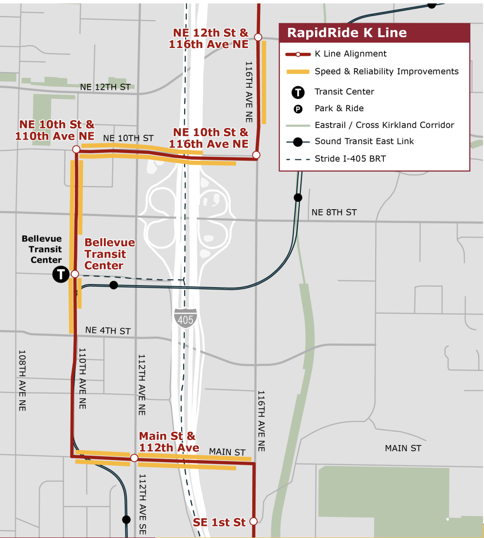
Some of the proposed BAT lanes were from the 2014 transit master plan, and some additional ones were added to make the project more competitive for FTA funding. Most of the proposed BAT lanes are converted general right-most lanes, though two sections would be created by widening the road.
- 116th Avenue NE northbound, from NE 10th Street to NE 12th Street. This project would implement a BAT lane by widening the roadway from NE 10th Street to Felix Terry Swistak Drive NE.
- NE 10th Street westbound, from SR-520 onramp to 110th Avenue NE. The existing outside lane would operate as a BAT lane.
- NE 10th Street eastbound, from 110th Avenue NE to 116th Avenue NE. The existing outside lane would operate as a BAT lane.
- 110th Avenue NE northbound, from NE 6th Street to NE 10th Street.
- From NE 6th Street to NE 8th Street: The existing outside lane would operate as a BAT lane between,
- From NE 8th Street to NE 10th Street: The existing parking lane would operate as a BAT lane.
- 110th Avenue NE southbound, from NE 10th Street to NE 4th Street.
- From NE 10th Street to NE 9th Street: The existing parking lane would operate as a BAT lane.
- From NE 9th Street to NE 8th Street: The existing outside lane would operate as a BAT lane.
- From NE 8th Street to NE 6th Street: A new outside lane being built by development would operate as a BAT lane.
- From NE 6th Street to NE 4th Street: The existing outside lane between would operate as a BAT lane.
- Main Street westbound and eastbound, from 110th Avenue NE to 116th Avenue NE. The existing outside lanes would operate as a BAT lane.
KCM provided a full list of 15 Speed & Reliability improvements for RapidRide K in the City of Bellevue to approve as well. Some prominent ones in addition to the ones described earlier are:
- 108th Ave NE (Southbound) at Northup Way: Bus-Only Left Turn Lane from right lane
- 145th Place SE at Kelsey Creek Road/24th Street: Convert to roundabout (high cost)
- 116th Ave NE (Northbound) at Northup Way: Bus-Only Left Turn Lane
Federal Funding timelines and Conclusion
KCM will ask the Bellevue and Kirkland City Councils to provide letters in support of the LPA in March 2025. KCM must have the cities’ letters to be able to apply for FTA (Federal Transit Administration) funding for the RapidRide K Line.
Bellevue City Council might not approve the KCM proposed alignment given that in July the council highlighted some objections to using the 110th Ave NE alignment for transit treatments previously and preferred 108th Ave NE. From traffic analysis, both 110th Ave NE and 108th Ave NE have similar traffic volume counts.2 The Main Street BAT lanes seemingly had large council favorability.
Main and 110th seem obviously preferable to me. If Bellevue wanted to put more buses on 108th, they should have put the Link station there.
The argument for shifting the K further west is that the line connects to Link at other locations, that is, if you’re coming from the north, use Whole Foods station, coming from the south, use East Main Street station. These other stations make the connection to Link at downtown Bellevue station less important, and giving that up allows the K line to stop closer to more destinations within downtown Bellevue itself.
The counterargument is that the chosen route is faster for thru riders on the K line bus, and the walk from bus stop to Link station is slightly shorter at the downtown station vs. Whole Foods. And that routing the K to use 8th St. instead of 10th to put it closer to Whole Foods station would come at the cost of subjecting the bus to more risk of traffic delays.
Overall, I feel the chosen route is as good as any, but I feel the real problem is that the downtown area you really want to cover is too big to do with just one bus without lots of slow zigzagging. There is also the problem of how to cover the retail area east of 405. So far, the indications are that Metro has no real interest in serving it well. At least there’s now a walking path from whole foods station, which helps a lot. As does the fact that many/most carless people will opt to shop online, avoiding the store trip altogether.
I like 108th slightly more since most likely most riders are getting off to go to Bellevue rather than transferring to Link, but 110th seems fine to me. It’s faster for through riders, saves vehicle hours for Metro, and walking through downtown Bellevue isn’t too bad.
I think downtown Bellevue is compact enough that passing through the edge of downtown is not that big of an issue. I think the area the misses out the most is the Old Bellevue area (around Main and 102nd). That’s a 15-20 minute walk from the transit center or from East Main station. The walk down Main is fine but not very comfortable, though there are plans to improve it (below)
https://bellevuewa.gov/city-government/departments/transportation/projects/neighborhood-projects/main-street-multipurpose-path-intersection-improvements
I’d like to see the planned 240 and 554 route through Bellevue following the same route as the planned 249 (via NE 4th to Bellevue Way). That would make a nice, frequent “spine” from the transit center through downtown to Old Bellevue.
City of Bellevue probably doesn’t want anyone touch the bike facilities they just put on 108th not long ago. 110th is pretty car-centric right now and can use some multi-model improvement from K Line project.
I like 110th more because its land use is more diverse. It is almost all office buildings along 108th with unconsolidated unsignalized parking garage access randomly interrupting traffic from time to time.
> I like 108th slightly more since most likely most riders are getting off to go to Bellevue rather than transferring to Link
110th is also Bellevue. Respectfully, stop centering downtown Bellevue at The Mall. City Hall and the transit center are a far better location to orient yourself around. Yes, there’s that big scar of a highway just a block away. But downtown is moving east, away from The Mall. Let it.
“downtown is moving east, away from The Mall”
That’s the question, is it? A retail/restaurant area like Bellevue Way and spilling over to 106th gets people 18 hours a day and a large cross-section of the population. An office area gets only 9-5 workers, and even the restaurants close at 3pm and won’t deign to serve dinner or weekends when; e.g, I want to eat. 108th and 110th have gotten highrises but it’s mostly offices. There’s not yet any indication that a wider range of destinations or cultural activities are coming to the immediate station area.
Signal at SE 8th @ Lake Hill Connector is timed in a way in favor of clearing SE 8th approaches. That could create some delay for K Line southbound trips during PM peak.
Before this came out, I was hoping maybe they would choose SE 8th alignment and put Wilburton P&R to better use.
People normally don’t drive to a park and ride to ride a local bus like the K, only an express bus to Seattle. If Wilburton park and ride is not well used by carpools and vanpools, the land should probably be sold to a developer for housing. And since it’s an ugly pile of concrete by a noisy freeway, whoever buys it ought to be able to build something big on it without nimby neighbors complaining.
Route 250 now and the K line of the future should serve the two Link stations north of downtown Bellevue, both the Spring District and Wilburton, so serving the downtown Bellevue station on 110th Avenue NE is less important. The BTC should be extended east and have a pair of stops on NE 6th Street just west of 112th Avenue NE so I-405 bus routes have short walk transfers with Link; they use the NE 6th Street center access ramp.
oops. not Wilburton. Route 250 and K line could remain on NE 10th Street.
What routing would you suggest to Spring District? It’s quite far out of the way
Use 120th Avenue ne between northup way and ne 12th street. Do not serve 116th Avenue ne between northup way and ne 12th street.
The station is between 120th and 124th so those are the only choices. 120th seems better because it’s less out of the way, not a freeway interchange, and is the same street as the recent big-box stores south of 8th. The proposed K and current 250 go north on 116th north of 12th, so it would be four blocks further east or one superblock.
I’m not sure the tradeoff is worth it. It’s only a minute or two further during off-peak but it’s significantly longer during peak hours because the multiple signalized intersections between Northup/116th and Northup/120th back up into one another. The turn from 120th to Northup is especially bad and often takes multiple cycles to get through.
In an ideal world, I think there would actually be two bus routes between Bellevue and Kirkland. One that takes Bellevue Way/Lake Washington Blvd. all the way, the other that meanders east and back west again. If we had such a direct Bellevue Way bus, then, for the other bus, going 120th to 4th makes a lot of sense, since it’s really for the intermediate destinations rather than all the way through.
In the real world, of course, limited service hours make this impractical – to fund both routes, you’d have to cut frequency to the point where it’s not worth it anymore. So, we have to make due with only one Kirkland-Bellevue route, which means compromises. Shopping destinations are relatively easy to compromise on, since there are plenty of alternatives with either online shopping, or visiting different stores with similar merchandise. For example, of the K line is too far of a walk to the Trader Joe’s on Bellevue, you can take the K the other direction and shop at Trader Joe’s on Totem Lake.
To asdf2’s point, if you showed me some information on Bellevue and Kirkland land use, and then told me there was a history of successful freeway-bus routes on 520, including some pretty extensive recent construction including two in-line freeway bus stops along 520 between the lake and 405 just a few years ago… well, I’d guess that one of those bus stops was at Bellevue Way/Lake Washington Boulevard, and that there was a frequent, moderately popular bus route taking that direct route between Bellevue and Kirkland, connecting to the 520-based routes at the freeway station, allowing this connection without any loops or wildly out-of-direction travel. And the other 520 bus stop… I guess it would be some lightly-used park-and-ride in the points communities somewhere, planned in the hope that the rich people would feel they were getting something and wouldn’t bother opposing the project too much.
And then you’d tell me, “Actually, we build two points P&Rs, and every bus route in the area twists around South Kirkland P&R.”
Cars will rule us forever.
I don’t see Metro revisiting the general streets on the route. I might suggest changes but I think that the consensus on that has occurred.
I’m kind of surprised that the stop locations themselves aren’t being discussed. There is just this representative dot that is actually two stops — one in each direction. For example some stops look difficult to create at the exact spots because there is a slope or an awkward turn involved. The one that is most obvious to me is the Main Street stop at East Main Link Station. But any stop at a left turn point will have to be after the intersection. It’s hard for a bus to turn left right at or after a stop — unless some extra features are added to make that happen safely.
The concern about East Main is about the slope and not turning, by the way.
I’m hoping Main St stations are both on the west side of the Main/112th intersection. There is a new local stop Westbound on the north side right by the new Broadstone tower, hopefully that becomes a K RR station. This only requires crossing Main street to get to the station. Eastbound, I’m hoping is located on the west side by the new park (which would require not needing to cross any streets to get to the station). Do not want stations on the east side of the intersection which will require crossing streets unnecessarily to get to the station – this will further delay riders and would be dangerous as it encourages running across the street to catch a bus.
For Main St & 112th Ave NE:
West bound direction: there’s already an existing far-side bus (and shared bike) stop https://maps.app.goo.gl/gqKBADgrdhYp56L97. The bus will make a right turn up Main Street so it’s fine.
East bound direction: the bus stop doesn’t exist, but generally it’s far enough from the left turn that both far side and near side bus stops would work. the east bound bus only needs to cross one lane, I don’t a reason why it wouldn’t be able to get there. Bellevue might just prefer they build it on the far side though
Need to make sure 116th/10th station (southbound) has a new crosswalk across 116th to access the pathway behind Whole Foods. I’m afraid traffic engineers will dictate station locations in poor locations and forbid crosswalks for fear of impacts to traffic flow (keeping away from the intersection due to turning traffic). Already the existing B line stations on NE 8th don’t serve Wilburton station despite passing under it.
Maybe the B line stops were put there to discourage jaywalking across 8th. I suspect we’ll see a lot of folks just cut across the street, the same way they do on Montlake next to Husky Stadium. Google street view even catches someone in the act: https://maps.app.goo.gl/obhfkcUdbxMe7ie3A
The bridge is certainly better than nothing but it’s quite high up and annoying to cross as a pedestrian. Also, there’s not even an entrance on the west side of the station; after crossing the bridge, you have to circle around the station to enter. At some point I hope Bellevue or ST adds an entrance on the other side of the street. I think there is enough room between the tracks to add a walkway and a set of stairs.
This is getting pretty off topic but I wonder how hard it would be to tunnel (or cut/cover) another entrance to UW station from the corner of Montlake/Pacific. The Triangle Garage has a direct tunnel; why not one for the light rail station?
> Maybe the B line stops were put there to discourage jaywalking across 8th
Poncho is talking about the missing westbound bus stop. Aka near here https://maps.app.goo.gl/ZgVDX5AZ6PBFb1C9A It probably doesn’t exist because bellevue didn’t want the bus to block traffic, otherwise it’d be perfect for a bus stop.
For the eastbound bus stop https://maps.app.goo.gl/A5ZD2XE2jvAUNzoDA there’s no reason to ever get off there (for transferring to link). If one wanted to use the link one would get on at downtown bellevue staiton.
From what I recall from others discussing in the past it is possible to make a tunnel connection, just that UW didn’t want it as it’d go through their garage. I can’t find the source for that at the moment though.
It’s not an issue now but when Link goes to Seattle this will be a more prominent transfer location. At a minimum move the WB to in front of the station. Existing EB stop is in front of a gas station across the street where you have to walk a stretch with no sidewalk. This has to move to be by the Burger King and Eastrail given that impediment.
UW station ped tunnel needs to be added to a list of future capital projects. UW should be paying for it too given they shoved the station in that terrible location and also serves their hospital. If UW station is going to be a major Link-to-520 buses transfer hub as it is, the transfer situation needs to be exponentially better. I’d also look at buses going on NE Pacific Pl, cross Montlake Blvd, go behind the station (BTW station and stadium), then use Montlake/Walla Walla intersection and cross the Montlake Bridge. The 255 does this route in reverse for the Seattle-bound direction.
In addition to what Pancho wants:
• there should be an elevator shaft that goes directly between the triangle island bus stops and the Link station. The bridge works, but adds unnecessary time.
• in many cities with deep subway stations, escalators are used to extend the reach of the station by traveling both horizontally and vertically. London, Atlanta and Moscow are three of the ones I can think of. This could probably be made to reach fairly deep into the actual UW campus. As for elevator access, the Puget Spund region has at least one manufacturer of diagonal elevators, primarily used to access docks at the base of steep hillsides. So, something like that could work as a miniature funicular.
I never realized the B has a missing westbound bus at the Link station, and, yes, there should be one there. If you have to be on Link anyway, making the switch at Whole Foods station is faster – no point in sitting in traffic on 8th St. across 405 if you don’t have to.
“you have to circle around the station to enter.”
You have to circle around the station like you do at Lowe’s or Sky Nursery? I thought Metro and ST were transit agencies.
I believe Metro tries to place stops next to crosswalks to discourage jaywalking (again, see Montlake). 8th/116th WB doesn’t work because of the freeway lane, so it has to be 8th/120th.
Good point. I think right now I don’t see much of reason why I had to cross there, but with a RapidRide stop there in the future, they need to add the missing crosswalk.
Wilburton Station’s situation is much worse I think.
I took bus from Bellevue Downtown to there a couple times to have lunch at food court of Uwajimaya or Wholefoods (because there is no way to walk there) and it was a pain in the ***. I think they kinda assume that is a ped bridge there so they crossing NE 8th is not a problem, but the ped bridge is just hard to use because it was not designed in a way for people along NE 8th just cross NE 8th
Whenever I go to Uwajimaya, it will have to make a big detour to cross the street at least on one way. I took B Line in the end because I realized at least my way to Uwajimaya doesn’t requiring crossing NE 8th.
I really wish that ped bridge can be more directly connected to NE 8th sidewalk on the south side and light rail station. A 3-level light rail station (like TIBS) with second level align with ped bridge could have solved B Line and light rail station accessibility problem there.
The station could have a walkway extend across the street from the center platform, similar to the Judkins Park entrance across Rainier. I don’t think it would be that expensive or difficult to build
I agree though, that whole area is a pain to walk through
There is really no good reason for not having a crosswalk on the street in addition to the bridge. When the cars would be stopped anyway at another stoplight a few hundred feet down, what difference does it make if drivers have to stop a little bit sooner to let people cross. Is Bellevue really this bad that we can’t allow people to cross the street at all, lest it delay drivers turning into the whole foods parking lot by 20 seconds?
The bridge is certainly a lot better than nothing, but it’s primarily designed for thru north-south bicycle traffic, not local pedestrian access to destinations on the other side of 8th.
@John D
Since you mentioned that. I’ve always wondered the same thing.
The light rail bridge girder south of NE 8th almost made me wonder looks like a structure reserved for additional station access. If you look at the north end where there is a similar 40-ft spacing between track centerline, they used columns to support each elevated guideway. Only on the southside they decided to put a girder on top of a single column to support both elevated guideway. That girder just looks like it was designed to carry some additional elevated space between tracks.
It is also possible that they designed it this way to avoid any land acquisition or utility underground. It doesn’t seem that any properties southside of NE 8th was displaced due to light rail construction. They must have put down some effort to come up with this design to save money.