
Edit, 11:40am, February 21: Sound Transit provided a newer map of the Federal Way Station area, reflecting a design change moving the bus terminal to be directly adjacent to the light rail station. The article has been updated with this information.
Since Federal Way Link is opening in 2026, here’s a brief overview of the 3 stations opening next year and their layout. The diagrams are from the open house and photos from City of Kent and Sound Transit. The stations’ existing poor walkshed will be improved with a new street grid. Biking to destinations east of I-5 will be moderately improved by new bridges, though new I-5 off/on ramps will also increase car to bicycle conflicts.
Kent Des Moines

Kent Des Moines Station is the first new station south of Angle Lake Station.

The elevated Kent Des Moines Station will provide access to Highline College and surrounding neighborhoods and businesses. The station is elevated straddling over S 236th Street. There would be staircases and escalators both north and south of the new S 236th street.

The station will have three landscaped streets to promote easy access by walking, bicycling and transit. Two large plaza areas will feature landscaping, seating and public art. An additional plaza near the garage will include a covered seating area and space on the street for food trucks.

and the station location chosen is located a bit north of the actual station site.
The station would have decent connectivity west and south. Interstate 5 hinders traveling east. You’d have to go north to the Kent – Des Moines Road crossing, and if you’re walking or biking to downtown Kent, KDM Road has an unsafe narrow sidewalk next to high-speed traffic.

There are some plans by Kent to construct a new north-south 32nd Avenue S street from just south of Kent-Des Moines Rd to S 240th Street with bike lanes and sidewalks on both sides of the street. A new east-west trail would be built extending S 244th Street from SR-99 east to the new 32nd Avenue S street.

The new SR-509 extension stage 1b would add wider sidewalks and a shared-use path on SR-516 under I-5. This will moderately allow for easier pedestrian and bike access across I-5.
On the other hand, the new southbound off ramp from SR-509 and new northbound ramp onto SR-509 will also increase car traffic on the under-crossing. The new Veterans Drive I-5 under-crossing is only for automobiles.
WSDOT has already almost finished construction of the previously mentioned stage 1b, but stage 2 is still in the planning phase (between 24th Avenue South in SeaTac and South 188th Street near the airport). There was a SR-509 stage 2 extension open house with more visualizations online.
Star Lake

The Star Lake Station would be located just west of I-5 and north of S 272nd Street.

Located at the existing Star Lake Park-and-Ride site, the Star Lake Station features a 1,100-stall garage that will replace the existing surface parking lot. Sound Transit rebuilt a portion of South 272nd Street to improve vehicle/bus access (Route 183) to the station. Portions of 26th Avenue South and 28th Avenue South will have new sidewalks with landscaping. A pedestrian/bicycle path will connect the station plaza to the existing freeway bus stop.

Federal Way Downtown

Federal Way Downtown will be the new southern terminus.

Located in the city center, the elevated Federal Way Downtown Station would serve several Sound Transit, King County Metro and Pierce Transit bus routes. A new street grid enhances access to the station and provides an opportunity for future development. The plots of land for construction staging will be converted to transit-oriented development (apartments) afterwards.

An expansion of the existing parking garage will accommodate an additional 350-stalls when the light rail opens.

The Federal Way Downtown Station would have moderately good connectivity to the north, south, and west. A new street grid will help pedestrians reach the south-west a bit better. Connectivity to the east is mostly blocked by I-5 with the only path via S 320th Street.

Just north of S 316th, Federal Way has approved converting the Town Center 3 property ( former target site) into 1,600 units of housing as well as adding a civic plaza.
Commons Mall Future
The Commons at Federal Way mall recently attracted Amazon Fresh and Dick’s Drive-In. Future plans might include some infill 650 apartment units built in the “Texas Donut” style with a parking garage in the center.

A new signalized crosswalk along with a pedestrian refuge island could be built with realigned 21st Ave S.

The Federal Way city council has also considered a more ambitious and expensive plan to trench South 320th Street under a 21st Avenue South pedestrian bridge. Some major complications are moving the utilities under the road.
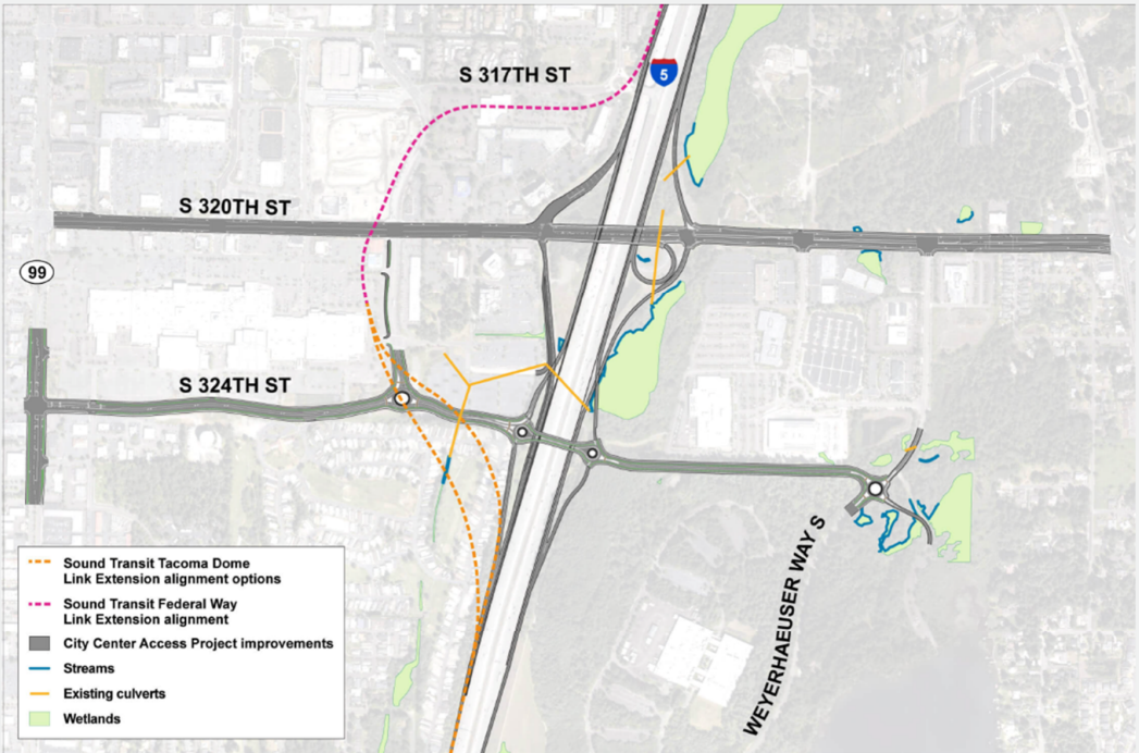
The Federal Way City Access Project plans to add a new I-5 over-crossing at S 324 Street south of the existing bridge. While the main goal of the project is adding car access to and from I-5, the project will also add a new bike path to S 324th Street for bikers and add HOV lanes to the existing S 320 St bridge for bus routes 181 and 187.
While the project will add bike access to the east of I-5, it is a bit hard to label the project as unequivocally better for bikers considering the four on and off ramps planned at S 324th Street.
Conclusion
The Federal Way Link extension will help connect Kent, Des Moines, and Federal Way to Seattle and the rest of the Puget Sound Area. New street grids will help pedestrian connectivity for people to walk to and from retail and apartments. New freeway underpasses and bridges will provide new bike connections east of I-5 albeit with the corresponding increased car traffic.
I cannot click on the pictures to make them larger for readability, like I can for other STB articles. I think that is a setting on WordPress, can you change? Some of these pictures are very detailed.
Other than that, this is an awesome, detailed post that looks like it took a lot of time to prepare. The links to the source docs are very helpful. Links to blow-ups, like on the last pic, are still helpful.
Thank you, Wesley!
The images have been updated to be able to be opened full-size.
Best feature of the extension is that there are zero at grade crossings anywhere. Love to see the elevated stations finally become the preferred standard in suburban rail. Now if only Rainier Valley could get the same treatment.
Multiple 2-Line stations are also at-grade, although not in the middle of an overly-wide arterial street. Add to that SODO and Stadium.
Sodo and Stadium are at grade for now, but the Lander st. and Holgate st. overpasses planned for WSBLE will essentially grade separate that portion.
Agreed, but the long station spacing increasingly exposes the technology choice of BART del Norte as a fiasco. Fifty miles of Slow-Floor Tram running will essentially rebuild the Seattle-Everett and Seattle-Tacoma Interurbans except that long stretches will be on structure.
“Hooray” for the structure! “Boo” to the trains running on it.
Yes, I understand the “history”, but it’s an embarrassment.
It’s technically at-grade in parts of I-5 right of way, so it has the low-cost advantage of being on the surface but can leverage the freeway’s under/overpasses to avoid level crossings.
Elevated on 99 still would have been better for walkability and ridership. Kent wanted it, but Des Moines and Federal Way didn’t.
Mike, I agree that if you’re going to wrap rail transit within the envelope of a freeway right-of-way, it definitely makes sense to create a standard three-foot railroad grade mound on which to build it, since there will be only the rarest of intrusions, if any at all.
The real problem is that the system is being built to the lowest-common-denominator “Light Rail” specifications while at the same time attempting to span many miles of track-speed running. The trains need to be faster, but if the existing technology is made to provide a higher top speed, it will not accelerate and brake as nimbly.
Pedestrian refugee island, I think we should make that standard terminology.
In this case, it is a head-scratcher that the south end of the station was not extended further south, so riders would not have to walk across the very busy S 320th highway.
OTOH, such an extension might have been treated as a pedestrian bridge, complete with a false expectation that all pedestrians would go out of their way to cross the street via the station platform.
I hope they remember to include beg buttons and curb cuts on the refugee island in the middle of this game of Frogger.
I rode Link the other day and I noticed that someone had been peeling off the “Federal Way Downtown Coming Soon” overlay stickers.
Obviously some people are impatient for this extension to open.
But we should have 3 new extensions open in about a 14 month timeframe. That is awesome.
I am one of those inpatients, but I suspect the sticker peeling was an inside job, since Downtown Redmond and the Great Conjunction are coming first.
ST “promised”, er proposed, to have ST Express 574 serve Angle Lake, which would have made for a smoother connection between much of southeast Seattle and south King County, and Tacoma. And Federal Way too.
Some will complain about the new forced transfer at Federal Way to get to the airport, until they experience not having to spend a long time on the airport terminal loop.
What I am really impatient for is an all-day frequent bus route between Federal Way and Olympia, so legislators can stop bemoaning the dearth of transit lobbyists.
I never understood why ST would put a sticker over Federal Way Extension diagrams but completely ignored full East Link / full 2 Line which opens earlier. I think every diagram is going to have to change to show the full 2 Line and the two stations before this extension even opens.
Because Full ELE will be interlined all the way to Lynnwood. So you’d have to have a sticker over almost the entire diagram. Just not worth it.
Adding the sticker over FWLE is much easier. But ultimately it is part advertising and part precautionary. Opening Full ELE on sched is still somewhat sporty, and when those charts went up it wasn’t 100% clear which extension would open first.
Remember, Full ELE had The plinth problem, but FWLE had the soil problem. It was far from clear originally which problem would be solved first.
Incidentally, I walked by JPS today and there is an LRV parked at the east end. So they do appear to be making good progress on that extension.
@ Lazarus:
“Adding the sticker over FWLE is much easier. But ultimately it is part advertising and part precautionary.”
I’m sorry. It appears to just be an internal design mistake by ST graphics staff to include Federal Way and Pinehurst as stickers but not include the full 2 Line.
1. Federal Way Link operation depends on getting extra vehicles that can only realistically be provided if East OMF is connected to the system. So full East Link / 2 Line almost has to open first.
2. It’s possible to show future extensions without using stickers. ST could have just shown Federal Way Link stations coming soon on the produced base diagram. And they could have shown that a full 2 Line was coming soon too by simply adding a second dotted line onto the map above the solid 1 Line line. Stickers only made sense for the Downtown Redmond extension stations — and I even think those station names may have slightly changed since the current diagrams were printed.
Tte one good thing is that all of the onboard diagrams appear to be easily removable and not very expensive to replace. I suspect that ST will roll out completely new diagrams later this year with removable stickers only for the three Federal Way Stations and Pinehurst (curious what name ST has currently called the station underneath that latter sticker as it just got a new station name), and those should last well into the 2030’s.
A future diagram could even reference the next extensions as conceptual if they want for political reasons. DC Metro did that for a few decades before their core system fully opened. However, I see no reason to add cover stickers for WSLE or TDLE stations as those conceivably won’t open until the mid 2030’s if at all — and surely ST will choose new names for some of those stations as well.
@Al S,
“ It appears to just be an internal design mistake by ST graphics staff to include Federal Way and Pinehurst as stickers but not include the full 2 Line.”
Not correct.
The Pinehurst thingy is not included as a sticker. It is just a grayed out ghost of a mention. And that is smart, because barring the completely unseen, Pinehurst is almost certain to be the last to open. So no sense wasting money on a sticker when the complete display will be replaced for Full ELE anyhow.
They will probably include Pinehurst as a sticker when they replace the full display for Full ELE though, and that is smart too.
And if they do get it wrong and Pinehurst somehow opens before Full ELE, then they could always add an “open” sticker after the fact. They can probably print them 30 to a page.
“1. Federal Way Link operation depends on getting extra vehicles that can only realistically be provided if East OMF is connected to the system. So full East Link / 2 Line almost has to open first”
Exactly, but so what? If FWLE was to open just before Full ELE , then Full ELE would almost certainly be available for non-revenue LRV moves. Meaning East OMF would be available to support FWLE opening first. And that is a good thing.
But hey, there is a lot going on with Link right now. A year from now transit will be completely transformed regionally. I can’t wait..
“The Pinehurst thingy is not included as a sticker. It is just a grayed out ghost of a mention.”
I didn’t know that. I’m not in the habit of defacing ST diagrams on trains to satisfy my curiosity about whether or not it’s a sticker.
And to be clear, the “mistake” wasn’t putting Federal Way stations as coming soon. It’s merely the choice of making it a removable sticker that was the mistake. They should have instead shown FW Link as a placeholder like the Pinehurst placeholder you described above .
And in the unlikely event that FW Link does open before full ELE, that would have been the time to have put on a temporary sticker patch in top of the current diagram showing those stations.
It doesn’t make sense to put extensions that are years away on a train route map. The purpose of the map is for current wayfinding.
You may have to have a grayed-out link for an infill station, especially when the station box is already there and the train slows down as it passes it, and some passengers confuse it with the next current station and think the train is bypassing it. But that doesn’t mean it makes sense to have extensions, especially with all the stations and taking up so much space.
The most jarring part is “coming soon”. Soon is six months to a year, not multiple years out. That’s just raising people’s expectations for something they’ll have to wait years for. Especially with possible further delays if testing on the bridge crossing/plinths/Federal Way viaduct goes badly.
It can’t be that expensive to print a new map every year or so and install it on a hundred trains as segments open. That would be dwarfed by everything else that goes into an opening.
@ Mike:
You make some good points.
I would suggest only showing extensions actually fully funded and under construction as a good approach of when to show them . Riders do make longer-term housing and career decisions based on what they see is coming.
I prefer “under construction” as opposed to “opening soon”. That has no implied opening date.
It’s unfortunate ST made the map with “Coming Soon stickers”, because the map will have to be replaced anyway because the 2 Line station numbering goes the wrong direction, and it doesn’t show how it will connect to and overlap with the 1 Line.
@Mike Orr,
When Full ELE opens the entire map gets replaced, which is actually cheaper than making a large scale overlay to cover most of the current map.
But I thought the onboard maps currently showed SBS as being #56, which would be correct and consistent.
The numbers need to ascend going east, to not overlap with the northern stations. That was the biggest issue I heard. ST was going to have station 50 be CID, but moved it to Westlake. That decision may have come in time for the starter line map to be updated.
ST and the City of Kent more broadly are missing a super opportunity to connect the tiny chunk of Kent west of I-5 and its only Link station to the rest of the City and reap a development windfall at the same time. Build a bus-bike and pedestrian bridge connecting South 240th across the freeway. Continue the bike / pedestrian route down 240th to Military Road but build a busway that turns left to hug the northbound K-DM off-ramp up to just south of the Century Motel access road.
Widen K-DM Road just east of Military Road one lane for fifty yards and add a second bus-only left turn from K-DM to Military Road for buses from Kent City Center to access the busway quickly without the grinding mess at the freeway, 30th and Pac Hwy.
There would have to be a bus-only light to allow eastbound buses to turn left onto Military or (for another $15 million) a one lane overpass to a merge with eastbound K-DM Road just east of the Military Road. This bus-only bypass would save an enormous amount of time westbound (10 minutes at the rush hours by avoiding two in-traffic left turns) and probably four to six minutes eastbound by avoiding the freeway congestion.
Then upzone the strip between I-5 and Military from K-DM down to 250th. That would be a GREAT walk-to-Link area.
“access”, not “axcess”.
[Ed: Fixed]
Thanks “Ed.” :-)
I second this idea. An I-5 crossing of some kind on 240th would nearly double the walkable area for the KDM station.
Oh, and “Thank you, Weslie, for a great, in-depth article.” This is Transportation Journalism at its best!
Excellent local post. Thanks!
Yes it’s a nice summary.
I would have suggested adding more details about vertical circulation though.
– Federal Way and KDM have no mezzanine to deal with! However it appears that there are still about 45-50 steps (much fewer than Lynnwood CC Station with about 65-70 steps to the bus plaza). It’s not clear which direction they’re heading in. There are also two elevators off of each of their center platforms for redundancy which is great! I suspect that ST will have both going up although I would think that ST could have one up and one down during the evening commute if not all day. I would also note that if one escalator is out of service at KDM, a rider must cross the street to get to the other one.
– Star Lake is much more disappointing. There are no escalators and only one elevator for each side platform (no elevator redundancy and a design just like Mt Baker) . The station during itself looks very tight too so I doubt there is room to easily add any vertical device in the future. Its saving grace may be that it’s got very little to walk to around the station and will probably get almost all of its riders from people that drive to the station — and will be mostly empty except during the morning and evening peaks. At least it only appears to have about 30 steps.
It still amazes me how ST can build these glass palaces with such skimpy vertical circulation. Doesn’t any Board member have arthritis? It seems that ST practice is to do only a little more than the bare minimum for ADA compliance.
Hi Al,
I’ll try to add in a more detail for the next set of articles about the walkabllity (for the other stations)
I did consider talking about the alternative station ideas but it might have been a bit too much for one article
A Sound Transit spokesperson provided an newer map of the Federal Way Station area, reflecting a design change moving the bus terminal to be directly adjacent to the light rail station. The article has been updated with this information.
Thanks for doing that, Nathan! It is great that ST takes this blog seriously enough for the spokes folks to provide concierge service on requests like this.
Public relations people follow all relevant media outlets. Metro sends us corrections when we make a mistake about a route or plan. Political offices probably do too about what a politician has said or their position, although I can’t think of any particular examples. They don’t interfere when it’s a difference of opinion or a policy debate, just when facts are wrong or outdated. So somebody in the agencies reads all the articles about them. That doesn’t necessarily mean it gets to the decision-makers, who are the ones that matter in terms of affecting the outcome. But some politicians have told us they or some of their staff members read STB or have in the past, such as Dow Constantine. Sometimes people like Claudia Balducci appear in the comments to clarify or elaborate on their position. It happens rarely, and probably they’re silent in other cases for conflict-of-interest or political reasons. There have also been previous STB authors that have taken jobs in transit agencies and city governments and become silent, probably for similar reasons. There was also that assistant of a previous mayor who became a West Seattle transit advocate and then I think ran for an elected position; he appeared in the comments for a while.
Which of these stations are designed to allow buses to serve them with stops on the street vs. having to detour in and out of bus bays? As not every bus rider near a Link station is connecting to Link, designing the stations to allow buses to stay on the street saves riders time.
Bus loops at a lot of overhead – turning around at 5 mph, squeezing past buses in layover 1 mph, and waiting at stop signs and stoplights to get back onto the street again.
KDM will likely keep the bus stops on SR-99.
Star Lake is building a new bus plaza with way more capacity than could be needed by the current 183.
FW Station is moving the current transit center to be right next to the station, for little change to the detour buses currently take to the FW Transit Center.
So the current transit center “loop” is similar to the current center, where the bus is able to turn around inside the center, right? Leaving the same way the came in and accessing 317th, and the transit ramp to I-5 via the circle?
The aren’t going to loop through the entire downtown like they are doing now, I hope.
If you want to get a better idea of what the future Federal Way TC will look like, the TC roadway situation, and where it is located in relation to the current TC, I’d look up the latest Federal Way Link Flyover video, and go to the end of the video, starting around 4:18, and pause it. You’ll clearly see the TC roadways, bus bays, etc. One thing the video doesn’t make clear, however, is how certain bus routes will approach and leave the TC. It’s more obvious for some routes, but less obvious for others.
It looks like it’s about half as wide as the current center. I doubt they can turn around. Not sure why they are calling it a loop.
For federal way most of the buses will stop at the loop as it is the start/stop point.
For Kent Des Moines only a handful for bus routes end there. Rapidride a for example will continue on the street.
KDM: Both S 236th St curbs between Pac Highway/ 99 and 30th Ave S are listed as Bus Only. I suspect that route that end will pull into the eastbound ramps (south curb), lay over in the cul-de-sac (hope the buses can make it, and begin their routes westbound on the north curb.
Yes that’s correct you can view that map more at https://seattletransitblog.com/2024/08/22/rapidride-corridor-1056-route-165/ which shows the bus layover spots
It is not opening in 2026. They will find another reason to delay it again.
It’s useless to dwell on whether it might be delayed again when there’s no more likely date and no concrete reason for a delay. I’m not holding my breath that the full 2 Line will open on time, or Ballard for that matter, but we might as well take ST’s nominal dates until another date becomes more convincing. Assuming the lines might open on time allows people to make tentative plans on where to live or work, and for businesses to plan. Saying it will be delayed 1-3 months or years when there’s no specific reason for those dates, is just spinning your wheels and counting on your own imaginings.
There was no real reason for the original delay. What should be happening is Murphy delays should be factored into and deadlines. Since proper planning is something Sound Transit is against, we get broken promises.
Stuff happens on any and every infrastructure project, be thankful ST is doing its due diligence in ensuring passanger safety is paramount and not compromised by delaying the project.
Passenger safety? Really? That’s funny. If they cared about passenger safety they would actually make a serious attempt to enforce the laws on link.
What should be happening is Murphy delays should be factored into and deadlines.
Yes. Projects should have a wide range in terms of cost and timing initially. Basically an optimistic to pessimistic range (say 2 to 8 years). As time goes on they should be able to do the research and figure out in more detail how long it will take. So in the 2 to 8 example it might go 3 to 5, then 4. Or it could go 6 to 8 and then 8 (if the soil is as bad as the most pessimistic estimate).
There are cases (like the plinth fiasco) where something really unusual happens. Those are just bad luck and you really can’t estimate those. OK, maybe not luck — they could be considered system failures — but bad luck has something to do with it. Consider this example: For the World’s Fair in Montreal there were a couple of welders working on the finishing touches of the building. When welding they would occasionally set a little fire on the canopy but put it out with a fire extinguisher. The extinguisher was running low but they only had a couple little welds to do and they figured it wouldn’t catch fire (or they had enough in the extinguisher). They burned the entire thing to the ground. Oops. This can be considered a system failure (they never should have taken the chance) but it could also be considered bad luck (with just a little bit more in the extinguisher it would have been fine). I’m sure stated policy was to go down and get a fresh extinguisher but that didn’t happen.
Same goes for the plinths. There was a clear communication breakdown (a system failure) but also bad luck. An organization can make assumptions (they shouldn’t make) and still luck out. In contrast the problems with Federal Way are different. These problems are more basic. Either the engineers don’t know what they are doing (which is unlikely) or they aren’t communicating well with the rest of the agency and the public. The estimates were wrong.
The Federal Way unstable soils situation was the result of bad luck or insufficient geotechnical work (just like with the insufficient extinguisher, but with the geotechnical work costing a lot more to be “sufficient”). The bad soils span a few hundred feet of a 5-mile alignment. I remember reading through the geotechnical assessment for the FWLE EIS and it seemed they relied on WSDOT’s work for a lot of it, which makes sense since the alignment is right next to the freeway. But, somehow, none of the borings found the liquefiable soil layer, and it was only found during construction. Stuff like this happens with geology. It’s dark down there.
But it seems like you should count this as part of your estimate. The plinth failure was due to people doing something they should not have been doing. Setting fire to the dome in Montreal was due to people doing something they should not have been doing. In this case though they just assumed the soil was good. You should assume the worst in this situation (and make that part of your range).
In this case, they assumed the soils were consistent between two exploration boring locations – sort of like how the welders assumed they’d have enough extinguisher to put out a fire. In the case of FWLE, ST’s engineers could have requested more borings to decrease the space between to data points, but it costs real time and real money to do geotechnical drilling. Figuring out how much data is enough is the job of the engineers, and they apparently thought their data density was good enough for the 5-mile alignment. My guess is that ST is now going to take the most conservative approach possible to avoid another surprise $300M change order. But it’s unreasonable to design the whole alignment for the worst possible soils.
Not to the state the obvious here but the closer you are to opening date the more likely you will open on time. It is also worth noting that if you original date was changed (and in this case it was) the more likely you are to make the adjusted date. Telling the public “we won’t open this year” is painful. No agency in the world wants to do that. Once you do you add lots of float. It is much better to say “Sorry, we are opening two years later than expected”, then to say “It will be six months late” four times. It also gives you a chance to say you are “on time” (and “under budget”) even though that is only for the revised schedule (not the new one). This has happened repeatedly with Sound Transit.
That being said, last time I checked East Link was cutting it close with the *revised* schedule. But that is not the case with Federal Way Link. My guess is both will be “on time” with the revised schedule (just like Pinehurst station) even though they will considerably later than the original schedule. But if I was going to bet against a project (making the revised schedule) I would bet against East Rail. (But you would have to give me good odds — I think they will make it.)
KDS would be so much more useful with a gondola line running along 240th St / James St with a station at the Docksite Apartments, at Kent Station, and East Hill. Sounder riders could switch towards Seatac. It would be much faster connection between Kent downtown than any bus line climbing up the hill and getting stuck along Willis Rd.
Hard to see that being worth it. The Kent downtown is fairly small (even if it is bigger than most of the other “downtowns” in the area). That is what makes it hard to serve. It is very weak centered. The numbers for the various routes reflect that as the ridership downtown isn’t especially strong. There is decent ridership with Sounder but it is basically a transit hub and parking lot. If you work in Kent you take Sounder and maybe transfer. If you live in Kent you drive to the park and ride and take Sounder. Connecting the Sounder Station with the Link Station is fine with a bus — you get to serve a lot of places along the way. If you can’t take Sounder home (e. g. you come back in the middle of the day) then traffic isn’t that bad.
It still amazes me how ST spent all this money to get to 320th in Federal Way, including actually building tail tracks over this wide, high speed highway — yet did not provide pedestrian linkages to the south side of the roadway by just making a viaduct just a little wider.
I get that the 21st Ave connection is supposed to remedy this, but it’s still 400 feet to the west, and it’s lots more expensive to build than a simple walkway next to the light rail viaduct would have been. ST could have even just had the tracks separated just a little further with a head house on the south side of 320th and a walkway to the center platform.
Al, that bridge wasn’t “voter approved”. There is no such thing as a “good idea” at ST, regardless how much it might benefit riders or how little it costs, if it has not been “approved by the voters”.
Spend 1% of project funds on stubs for lines that might someday be built? Those stubs are not “approved by the voters”.
And, of course, to be “approved by the voters” an idea has to have been “suggested by the consultants” in order to be “included in a package”.
Ipso facto there are no “good ideas” at ST except those provided by the Platinum Plated Brigade.