By JASON LI
This is part 2 of a 3-part series on route 8. Part 1.
As the only arterial connecting Seattle’s second and third densest neighborhoods, Denny Way is one of the most important streets in the city. But as all locals know, it doesn’t work well for anybody right now, including drivers. It’s clear that something needs to change. That’s why the Fix the L8 campaign has been pushing for bus lanes in both directions along it since 2023 to ensure that this vital east-west connector can move as many people as possible. And it would help more than just Route 8 – Routes 1, 3, 13, 17, 24, 33, and RapidRide D also share Route 8’s headaches at Denny and 2nd.
Any bus lane in Seattle – especially on Denny Way – should include red paint and should be 24/7 to reduce confusion, boost compliance, and maximize effectiveness. Furthermore, while the bus lane would need to allow right turns for general traffic at most intersections, there are many redundant eastbound right turns at signalized intersections with high pedestrian volumes which should be restricted to minimize the impact of turning traffic. Specifically, 2nd Ave, Warren Pl, Broad St, Taylor Ave, Vine St, Bell St, Westlake Ave, Lenora St, and Fairview Ave can all be served by a turn immediately before those intersections. Denny and Westlake is especially problematic as extremely high pedestrian volumes mean each right turning car can delay the bus multiple light cycles.
Eastbound Denny Way has several redundant right turns like at Westlake Ave
Similarly, the right turn from southbound Queen Anne Ave to westbound Denny Way can easily be served by John St and should be restricted as it causes backups that impede the left turn lanes. We would also encourage SDOT to consider blocking the right turn from northbound Westlake Ave onto eastbound Denny Way. This turn has a dedicated phase, reducing time for other traffic movements, and drivers making the turn consistently block the intersection. This would surely impede a new bus lane on Denny and already mires the existing transit lane for Route 40, RapidRide C, and the SLU Streetcar, so restricting this turn would result in widespread speed and reliability improvements.
Finally, there’s one more right turn that would have the biggest impact of all if restricted: the turn towards the I-5 on-ramp. Blocking this would solve the root cause of most of eastbound Denny’s traffic woes while still leaving drivers with viable alternatives in the form of Mercer Street or the 99 tunnel to the north and Howell to the south. In fact, there is even a signed alternative route to I-5 from Denny Way at 5th Ave. Better yet, just close the Yale ramp entirely to move towards a city designed for people over cars, which would also greatly simplify efforts to Lid I-5. Who knows, traffic may even improve, just as it did when Seoul tore down a highway and restored the river that used to be there.
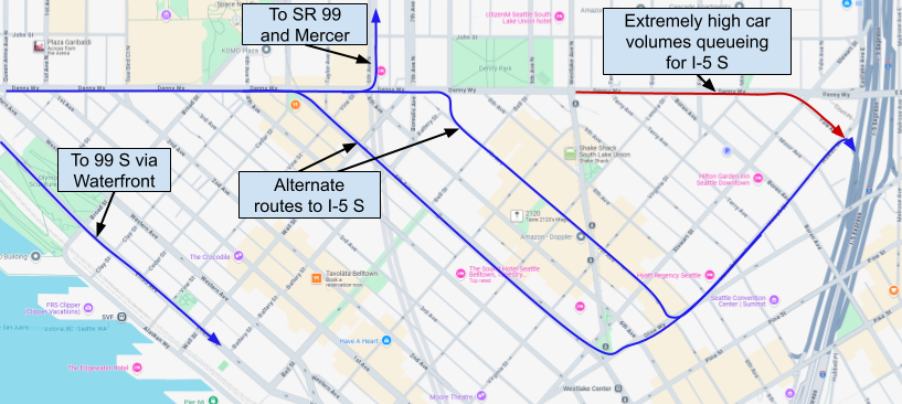
Alternate Routes from Denny in SLU to I-5 S
These changes are more important than ever as the FIFA 2026 World Cup approaches and pushes Seattle’s transportation infrastructure to its limits. For Route 8, this is especially true with Seattle Center hosting the World Cup’s Seattle Fan Celebration. This is Seattle’s chance to show that US cities can get transit right and leave visitors from around the country with a desire for their own cities to follow our lead. Instead, we risk embarrassing the city, confirming biases that America needs to be designed around the private automobile, and pushing visitors away from using transit at all in the city. It is imperative that SDOT install bus lanes on Denny Way before the World Cup, even if as a pilot program. Upcoming Revive I-5 work demands similar urgency as eventual closures of the Mercer Street on-ramps are sure to overwhelm Denny Way.
The Harrison Herring
SDOT has pointed at the Harrison and Mercer Transit Access Project as a potential solution for Route 8, with construction beginning as soon as next year. However, King County Metro has indicated that the route will remain on Denny and any service on Harrison would be new currently unfunded service hours. There is also a much larger project holding back transit in the area whose delays rivals that of Route 8: Ballard Link. Construction of the SLU Link Station at Harrison and 7th would render the transitway at least partially unusable until 2038. With Aurora Ave splitting the neighborhood in half, a protected bike intersection on Thomas, and a cliff separating John at Terry, the only east-west options available would be Denny, Mercer, or a lengthy zig-zag through SLU. King County Metro has indicated that this is prompting the agency to avoid significant service investments there, especially when combined with its upcoming fiscal cliff. This also makes the case for bus lanes on Denny even more compelling to handle the increased traffic this would bring while also serving as an effective detour for impacted routes on Harrison.
The SLU Ballard Link Station falls in the middle of the new Harrison corridor
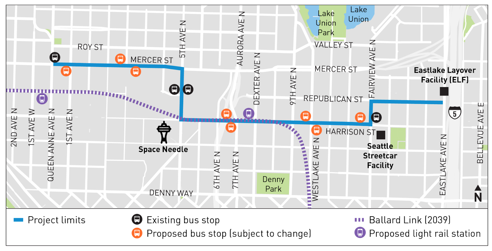
Furthermore, the Mercer-Harrison corridor would skip Belltown, the second-densest neighborhood in Seattle, while also moving away from many of the employment centers in the Denny Triangle. This loss of catchment area is significant, and Metro has emphasized to us that it is committed to maintaining service on Denny even after Harrison and Mercer is fully up and running. In fact, the Seattle Transportation Plan’s Frequent Transit Network even prioritizes Denny Way over this new corridor.
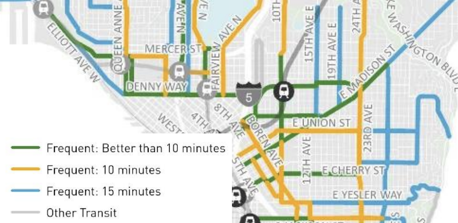
Seattle’s Frequent Transit Network calls for the highest tier of frequency along Denny Way
Finally, meeting the high level of service called for by the Frequent Transit Network would be unrealistically costly if transit priority is not implemented along the corridor. In fact, Metro’s 2024 System Evaluation already calls for three thousand additional service hours just to maintain a scheduled headway and prevent bus bunching.
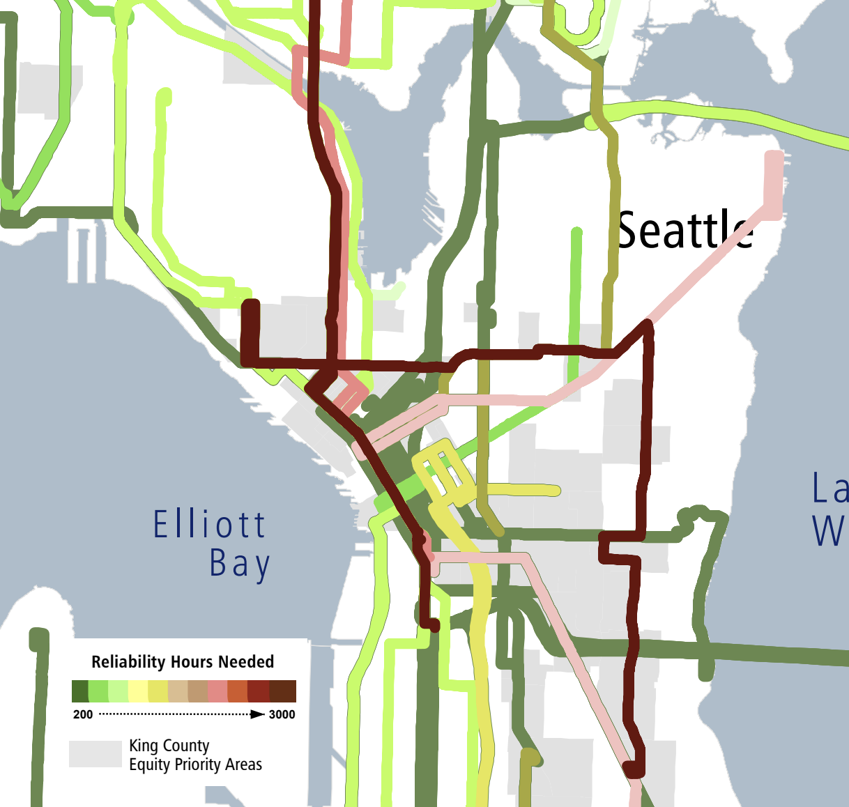
Denny Way causes Route 8 to require thousands of reliability service hours
It’s clear that bus lanes on Denny Way would not only solve Route 8’s headaches today, but would continue to serve as a vital long-term transit corridor for the city. If you want to help the Fix the L8 campaign to push Seattle to make this vital investment, send an email to our local leaders and consider joining the campaign! We are also hosting a Race the L8 event on July 10th at 5 PM to highlight the issues that Route 8 is facing, more details coming soon!
“Metro has emphasized to us that it is committed to maintaining service on Denny even after Harrison and Mercer is fully up and running.”
In other words, there will be a second route here. Perhaps that will be route 11 as some commenters have suggested?
We are strongly in favor of re-routing Route 11 onto Denny and it is one of the main suggestions we make in part 3 of this series. As for what overall service and route networks will look like long-term on Harrison and Denny after Ballard Link is complete, I think it’s far too early to say.
But Harrison corridor doesn’t connect to Capitol Hill, which I think is the main chokepoint..
If Route 8 were to be re-routed onto Harrison, it would still need to use Denny to cross I-5 and then immediately would turn on Fairview to connect with Harrison. The goal would be to skip the worst of the traffic on Denny, especially with the existing eastbound bus lane starting right after Fairview.
Long-term, the Harrison / Mercer corridor is still quite exciting for connections to Capitol Hill as it would unlock using Lakeview to cross I-5. KCM is also considering new routes to First Hill via Boren, but those would also work on Denny as well.
Jason Li, do you know why before the late 1980’s/early 1990’s, Denny Way (between the Seattle Center area and Capitol Hill), never had a public transit route?
The network was a hub-and-spoke design based around downtown (as the hub). This was quite reasonable given that a lot (if not most) of the ridership was based on getting to downtown. The city also has an hourglass shape so it a lot of trips were headed that way anyway. For example Ballard to Rainier Valley or UW to West Seattle.
As Seattle has grown it has outgrown its old network. Various areas that had very little development now have skyscrapers (including along Denny). A hub and spoke system can make trips really slow and the system wasteful.
I don’t have any expertise but I was there then. I think it was just that Seattle grew up from a small town in just sixty years. In the early years everything was downtown, so there was little reason to go from Capitol Hill to Uptown/Queen Anne because there were just small communities there. It took a long time to realize the city had grown enough to warrant a Denny Way route. My friend in north Lynnwood lived in a Summit apartment in the 1970s and walked to Queen Anne High School on Denny Way because there was no bus route and she thought it was too much overhead/backtracking to take a bus downtown and transfer. Without the Denny Way route, people had to do one or the other to get between them.
Yeah it is easy to forget that Seattle has grown considerably over the years. Capitol Hill was pretty significant and so was the area around Queen Anne Avenue & Roy. But there was nothing much between there. But that changed over time as the whole corridor filled in. You can kind of see that with a satellite view of things. Most of the buildings are clearly new. I’m not saying that Metro shouldn’t have added the 8 sooner but it is understandable that they didn’t add it right away.
Seattle had 250K people in the 1920s, vs 493-530K in the 1980s and 1990s.
For comparison, currently Bellevue (152K) + Kirkland (91K) + half of Mercer Island (12K) = 255K, matching Seattle in the 1920s. Seattle’s population was twice that in the 1980s, and three times that now.
I did a search, and it also gave an AI answer …
“The route 8 was established in February 1995, after a long period of lobbying by community members. Prior to its creation, Metro had cited a lack of demand and resources as reasons for not creating a direct bus line between Group Health Hospital and Lower Queen Anne. The route was initially funded by reducing service on other routes, like the 2, 10, 12, 13, and 43. The original Route 8 operated from 6 am to 6 pm, weekdays only, with 30-minute headways.”
“February 1995”: Possible, I don’t remember exactly when it started.
“lack of demand”: False. People had been begging Metro for a Denny Way route since at least the early 80s.
“lack of resources”: I don’t know about that. There was less public support for significant transit taxes in the 70s and 80s, but part of the problem was Metro’s general manager then: he thought buses were unnecessary beyond a minimal coverage network (if even that), and carpools/vanpools were the way to go. That’s part of the reason Seattle buses were half-hourly, suburban buses were hourly, they were very long milk runs to downtown stopping at every haystack, and 3/4 of the suburban routes were peak expresses to downtown Seattle. I lived through all that. I didn’t realize the general manager’s role until the 2010s when he and Kemper Freeman hosted an Eastside transportation forum and he revealed his attitude.
“The route was initially funded by reducing service on other routes, like the 2, 10, 12, 13, and 43.”: I didn’t notice any reduction on those routes.
“The original Route 8 operated from 6 am to 6 pm, weekdays only, with 30-minute headways.”: Probably.
The original route was Queen Anne to 15th, weekdays only. It was so popular that it was expanded multiple times, adding Saturday service, frequency, and extending it to Mt Baker. For several years it was extended to Rainier Beach, with the 8 remaining on MLK and the 42 branching to Renton Avenue. I don’t remember when all these happened; it was just several phases.
February (11th) 1995 is spot on. Here’s a 2014 STB article about this:
https://seattletransitblog.com/2014/08/18/the-creation-of-route-8/
which also links to this Metro service change pamphlet:
https://www.flickr.com/photos/126713233@N04/14958354252/in/photostream/
Wow, a blast from the past–2014. Metro really did stonewall the Broadway Merchants Association for more than a decade about the need for a Capitol Hill to Lower Queen Anne direct bus. But the 8 has been a roaring success–probably too successful for its own good.
Until there is enough surface infrastructure to run the 8 with reliability, I think Metro should look at truncating the 8 back to something resembling its original 1995 routing and offering very frequent headways between LQA and Capitol Hill. Ridership south of Madison along MLK is much lower and could be restructured to improve reliability–at the cost of frequency, however.
Ross, that makes sense. I didn’t think of hub and spoke.
Not sure what the solution to Denny Way is, but I do think the corridor is one of the best candidates for a gondola in the county.
Another excellent article. As you explained very well, Harrison is not an alternative to using Denny. Either the bus goes north to Harrison and then back south again (gaining nothing) or it bypasses Belltown (which is unacceptable). Harrison makes the most sense as a different route entirely. The best option (in my opinion) would be to combine it with a Boren bus like so. Notice that it makes very few turns. It goes straight across Denny just as the 8 would go straight on Denny. Northbound Boren basically becomes Fairview. Southbound most of the traffic is heading that way. You would need to add bus BAT lanes and other improvements on Boren but in the long run it would be worth it.
This brings up a nitpick. Technically what you are suggesting are BAT lanes, not bus lanes on Denny. Cars would be allowed in that right lane (but only if they are turn right at the next intersection). Excellent job considering the impact of pedestrian travel. Some intersections have a lot more pedestrian travel than others making right turns more difficult.
I like the idea of banning the right turn from Westlake to Denny. This would help the buses (and streetcar) that cross there as well as alleviate some of the grid lock that occurs there. It is likely that traffic would shift to Fairview which is better equipped to handle a lot of right turning cars. Denny has very few places where you can turn left — Fairview is one of them. Since there is a left-turn arrow from westbound Denny to southbound Fairview you can have a right-turn arrow from northbound Fairview to eastbound Denny (that operates at the same time). This would alleviate congestion which in turn would help the RapidRide J when they add BAT lanes northbound on Fairview across Denny.
The simplest thing to do with the Yale on-ramp is just close it. Otherwise it becomes a game of wack-a-mole. For example you suggested banning the right turn from Denny to Yale. Great. But you would also have to ban the right on Minor and Boren otherwise you are just shifting the backup.
Another approach would be to (variably) toll the entrance. That way when traffic is light drivers can use it for relatively little money (or for free). When traffic is heavy drivers would pay a big toll. Like closing the entrance it would shift traffic to Mercer which is fine. There are no buses on Mercer close to the freeway. Eventually you would want to add BAT lanes on Mercer and Mercer Place starting at Elliot and ending at Queen Anne Avenue (where the buses turn). But that is a project for a future time. It is still wack-a-mole but each time you do that some traffic just disappears.
Thanks, Ross!
Great point about the alternative routes to the Yale ramp via Minor or Boren, and I can’t think of a way to prevent that routing. I mainly focused on the right turn towards the Yale ramp as it has a lot alternate routing (even if we somehow stop drivers from taking Minor or Boren) and could likely be done without engaging WSDOT, but it seems like it would not be as impactful as I had hoped.
Definitely on-board with closing the ramp entirely as we argue for in the article but that would be a much harder battle as it would require buy-in from WSDOT and would anger a lot of people as that would leave Spring as the closest on-ramp south of Mercer.
As for bus lane vs BAT lane, I prefer to use bus lane as an overarching term just for simplicity, but I do agree that it generally implies no turns allowed. Confusingly, according to SDOT’s transit lanes page, the definition of BAT is that they are time-restricted bus lanes rather than 24/7 and I wanted to avoid that categorization, especially since that page also says “Like BAT lanes, some all-day bus lanes allow people driving to make right hand turns at intersections”: https://www.seattle.gov/transportation/projects-and-programs/programs/transit-program/transit-lanes#timerestrictedbusonlylanes
Maybe we can also think about thing from another angle. Like how to reroute general traffic accessing I-5 out of Denny Way so 8 will be more reliable running through there.