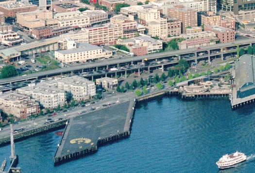
Over the past two decades, the City of Seattle, Washington State Department of Transportation (WSDOT), Port of Seattle, Friends of Waterfront Park, Downtown Seattle Association, Seattle Center, King County Metro, numerous community groups, and thousand of Seattle residents have contributed to redesigning and rebuilding Seattle’s waterfront. Years of debates, discussions, proposals, votes ($), and construction have culminated in the Grand Opening of Waterfront Park tomorrow, September 6.
The Grand Opening Celebration will occur between 11am-9pm with performances, activities, and games at the Salish Steps and Overlook Walk, Pier 62, Pier 58, Park Promenade, Pioneer Square Habitat Beach, and Stadium Plaza. The Salish Steps are the stairs/seating at the bottom of the Overlook Walk. A detailed schedule of events is available on the Friends of Waterfront Park website.

How We Got Here
In 2001, the Alaskan Way Viaduct was damaged by the Nisqually earthquake. After emergency repairs were implemented, City and State leaders were concerned about future earthquake damage to the aging structure. Replacement proposals included a new tunnel, a new elevated viaduct, and a widened surface street with additional transit. In general, the State preferred the elevated option because it was cheaper. The City government preferred the tunnel as it would be less disruptive to the waterfront. The City and State were deadlocked as Seattle needed State funding and Washington state needed permits from the City. In 2007, the Seattle City Council passed two resolutions calling for a non-binding, advisory vote on the tunnel and elevated options. The vote was on each option separately and Seattle voters rejected both options. The tunnel option only received 30% approval and the elevated option received 43% approval. Following this vote, efforts to promote the surface and improved transit option started again.
To further advance the project, officials from Seattle, King County, and Washington state signed an agreement to work collaboratively. This led to the creation of the Project Oversight Committee. The Committee included the governor, King County executive, Seattle mayor, chair of the Senate transportation committee, chair of the House transportation committee, one member from the King County Council and one member from the Seattle City Council. Additionally, a Stakeholder Advisory Committee was created to represent interests from local businesses, advocacy organizations, nearby neighborhoods, and labor groups.
The Project Oversight Committee analyzed eight alternatives and announced two preferred alternatives in December 2008. The preferred alternatives were a surface/transit option in the form of dual three-lane one-way streets on Alaskan Way/Western and an elevated highway in the form of two separated spans that allow commuters to bypass downtown. In response to the two preferred alternatives, Stakeholder Advisory Committee member and chair of the Greater Seattle Chamber of Commerce Tayloe Washburn proposed a new tunnel hybrid option to the Stakeholder Advisory Committee. This proposal included a tolled deep-bore or lidded trench tunnel between S Royal Brougham Way and Harrison Street, two or three surface lanes of traffic, and traffic flow improvements to I-5 and city streets. This option was supported by 22 of the 25 Stakeholder Advisory Committee members and sent to Governor Christine Gregoire for consideration. The Seattle Transit Blog did not support the tunnel alternative.
In January 2009, Seattle Mayor Greg Nickels, Governor Christine Gregoire and King County Exec Ron Sims announced the selection of the tunnel alternative. Washington state agreed to fund the tunnel construction and Alaskan Way Viaduct demolition. Seattle signed on to fund the Elliott Bay Seawall replacement, the waterfront surface street (Alaskan Way), and the now effectively cancelled Cultural Connector Streetcar. King County committed to unspecified transit improvements and the Port of Seattle provided $300 million to the overall project.
The 2009 Seattle Mayor election between STB endorsed (and future STB guest author) Mike McGinn and Joe Mallahan heavily featured debates about the planned tunnel. McGinn campaigned against the tunnel and Mallahan supported the tunnel. McGinn won the election by about 5,000 votes. In Feburary 2011, Mayor McGinn vetoed a bill from the Seattle City Council that affirmed agreements with the State regarding the tunnel construction. Seattle City Council members overrode McGinn’s veto with an 8-1 vote. The following month, a group called Protect Seattle Now filed a referendum petition calling for a vote on the tunnel decision. The referendum was voted on in August 2011 and passed with nearly 60% of the vote. That same month, the Federal Highway Administration approved the project clearing the way for WSDOT to start construction on the tunnel.
Tunnel construction was riddled with issues and cost overruns, but the State Route 99 tunnel finally opened to the public in February 2019. The Alaskan Way Viaduct was closed to traffic a few weeks prior, resulting in the over-hyped Carpocalypse. It turns out Seattle can survive without the tunnel or viaduct.
Throughout the 2010s, there was significant discussion and debate over what should replace the Alaskan Way Viaduct. The end result is a five to eight lane road, separated bike lanes, and a few new pedestrian spaces along the waterfront.
While the redesigned Waterfront Park is far from perfect, it is a significant improvement over a double decker highway viaduct. If you have not visited the waterfront in the past few years, use tomorrow’s celebration as an excuse to check it out.
If you would like to lean more about the Alaskan Way Viaduct’s history, History Link has an incredible four-part series by Jennifer Ott.
This is an open thread.
While the waterfront park is an improvement over the viaduct, it is still dominated by roadway and concrete. It’s mainly a road. It feels like more than 50% of the surface area is roadway and it’s not particularly bicycle or pedestrian friendly.
It’s a same that they didn’t allow the waterfront streetcar to be part of the redesign.
Absolutely. I assume the reason was car-brained waterfront vendors demanding easy tour bus and taxi/rideshare access, but the result is significantly less usable space in the area.
@Carl,
Oh, I fully agree with you, way too much concrete. Mainly too much concrete for roads, but even the pedestrian zones are oversized and have too much concrete.
But I will take it. It is a vast improvement over what was there before, and it would be much, much worse if McGinn got his surface road idea.
And I agree that the streetcar could fit into the new waterfront, but I would propose that it only stop at Coleman Dock to tie into the ferry system. The current bus system does a very poor job of that.
Also, streetcars can use green tracks. Which effectively expand the landscaping area and help reduce the heat island effect of the vast seas of concrete we have now. Would love to see such a concept proposed more formally.
You are talking about downtown, literally a concrete forest and sitting on 30 deg slope down hill. There is no hell way to avoid concrete structures. This is such an oxymoron to be urbanists while hating concrete…
There are a number of reasons for the excessive amount of pavement:
1) We run car ferries downtown. I’m pretty sure we are the largest city in the world that still runs car ferries downtown (I’ve tried to verify this but couldn’t). A lot of the lanes are basically storage for cars waiting to get onto the ferry. Ideally we would only run passenger ferries downtown.
2) SDOT overbuilt many of the roadways. Elliot Way is the biggest example. This is a small section that is easier to understand on a map than explain (https://maps.app.goo.gl/6bh8rArrGVUtPHMx6). It is two lanes, each direction. Nearby Alaskan Way is also two lanes, each direction. It crosses over Elliott Avenue in an awkward way that requires a lot of pavement. It is as if the assumption is that there will be a huge number of cars running downtown even though they built the tunnel. The strongest argument for the tunnel is that without it would we need to have lots of lanes downtown. We have them anyway.
3) Lots of surface parking. I get the need for short term load/unload. But the city should not be providing regular surface parking downtown. Not when you are basically starting from scratch.
I think the biggest problem is also the hardest to solve. Consider this trip from Bainbridge Island to the Seattle Center: https://maps.app.goo.gl/oRYNdDM2ggJJUiuD8. Notice that a driver gets off the ferry and goes right on the road I think is overbuilt. From that perspective it isn’t overbuilt. The cars have to have room to get off the ferry. But if the ferry dock is somewhere else then that road (and several others) can be a lot smaller.
The problem could also be mitigated with proper traffic control. But that gets really complicated. There is no easy solution.
The problem with running only passenger ferries downtown is that Bainbridge Island is very rural, not as much as Vashon, but surprisingly so for a place with such easy access to the downtown of a major city. If the Bainbridge run was passenger-only, the Bainbridge ferry terminal would probably need to have a parking garage (especially since it effectively serves the Suquamish reservation/casino and Poulsbo, and to a lesser extent the rest of North Kitsap and even the Hood Canal Bridge, as well) and a significantly expanded pick-up/drop-off area. (As it stands there have been times I’ve had to walk partway up the driveway leading to the pick-up/drop-off area to get to the car waiting to pick me up.) And on maps the Bainbridge run is presented as almost due east-west until it gets to Bainbridge itself, at which point it turns a bit north to get into Eagle Harbor; if you wanted to move the Seattle terminal for car ferries away from downtown it’s not clear where you’d go, as Fauntleroy is probably realistically too far out of the way. (The Pier 91 area near Magnolia maybe? But isn’t that a cruise terminal too, and could the Magnolia Bridge handle the traffic? And if you go into Shilshole Bay near Ballard, you don’t get very far at all before you hit the Locks…)
Elliott Way definitely seems to have been built under the assumption of creating a new arterial corridor extending from Alaskan Way, to the Western/Elliott couplet, to the Magnolia Bridge and 15th W/NW. I’m not sure why Elliott Way was considered necessary at all, though between Pike Place Market and the steepness of the hill in Belltown it does represent the only vehicular access between Alaskan Way and 1st Ave between Spring and Wall. I’m guessing the same “we have to accommodate trucks accessing the port” thinking that led to the tunnel itself was a factor; Seattle’s Truck Streets map seems to be very much out of date as it still shows the path of the old Battery Street Tunnel and viaduct (but does show the reworking of Mercer to be two-way), but the only non-freeway truck routes it shows between Denny and Dearborn west of Boren are Alaskan/Broad and Elliott/Western, so the corridor may have been thought to be necessary to bring trucks to and through downtown. (And yes, diesel-belching heavy trucks are a fantabulous thing to have on a tourist-oriented waterfront!)
The US Coastguard Base appears to be big enough to move the car ferries there. And provide much easier access to 99 tunnel and I-5.
It would be just outside of downtown enough that you could substantially pedestrianize the heart of the waterfront.
I would still run car ferries. I would just wouldn’t run to downtown. I would run new car ferries from Bainbridge and Bremerton to Fauntleroy. I would also run more passenger ferries from Bainbridge and Bremerton to downtown as well. It really doesn’t help anyone to have the car ferry downtown. I agree that a lot of people from Bainbridge are going to drive to the ferry terminal. But then what? If they are headed to work downtown (or many other places in Seattle) it makes sense to just walk. You save a ton of money and quite likely a lot of time. If they are driving somewhere else (which is quite reasonable) then driving through downtown is terrible. Might as well go to Fauntleroy or up to Edmonds (via Kingston).
@Cam — That location would certainly work but it would be a mess on game days. I think at some point you just have to bite the bullet and say “we aren’t that type of city anymore”. We’ve grown up. We don’t want people driving downtown.
Fauntleroy is kinda a crap place for cars to end up. Vashon and Southworth are low-volume enough that it isn’t a substantial problem. The same is not true for Bainbridge. That would be a massive traffic snarl every half hour. You’d probably need to add a separate doc. As it is, I’ve seen Ferries sitting offshore waiting their turn. It would be a cluster both on and off the water.
Dock.
I think game days are already a nightmare around the stadiums. You could simply force all ferry traffic onto 99, or have a game-modified ferry schedule that has an hour gap for the hour before and the hour after the games. Or turn them ped-only for those times, for those who want to go to the game.
Fauntleroy Way and the Fauntleroy dock are already a mess for regular non-holiday weekend ferry traffic, and if you think you’re going to be successfully able to push the infrastructure upgrades that would be needed for the Bremerton ferries in a hilly, wealthy, semi-suburban neighborhood, well, um, I have some NFTs to sell you?
But I find the discussion of alternative locations for the downtown ferries an interesting one, even if completely hypothetical. Someone mentioned the coast guard terminals, and what about the cruise terminals off interbay?
It gets really complicated because there are also a lot of walk-on passengers that need to go downtown. You’d need something the size of the Staten Island ferry to handle the peak crowds.
So, do you significantly increase the size of the passenger only ferry? Operate more transit to the new ferry terminal and make sure it coincides with ferry operation?
It seems to me we’re really not taking about that many cars. It’s about 200 per ferry, at most. The problem is, trying to deal with them in a quick fashion so they don’t delay the ferry.
So what about adding an upper deck to Coleman Dock and make it so that more cars can be queued in the terminal area rather than backing them up onto the street? Maybe create an overpass from that so disembarking cars don’t have to cross at street level?
Yeah, there is no question it would be a hard sell for Fauntleroy. We would probably have to scale down the number of car ferries from Seattle as well. I’m just saying it would be better overall. We really shouldn’t have car ferries downtown. It was OK when we were a tiny city but we aren’t now.
The Coast Guard location looks better, but it is still on the edge of downtown. Fauntleroy (and Edmonds) are not. If we insist on replacing the car traffic, then one option would be Harbor Island. Of course the Port would have a lot of issues with that.
So, do you significantly increase the size of the passenger only ferry?
Yes, absolutely. You would want to run it at least as often as they currently run the regular ferry as well.
@Cam Solomon,
Why on earth would anyone divert Washington State ferry traffic away from downtown? Ya, they are big scary looking ships, and they carry a lot of cars, but they actually carry more passengers than cars.
A typical jumbo class ferry can carry 200 cars, but it can also carry over 2000 passengers. So that is a potential negative impact to 10 passengers for every one car you wish to remove from downtown.
Of course that is just theoretical, but WSF keeps excellent records (because they charge), and the actual data backs this up.
For the Bainbridge ferry (the busiest going into Seattle) there are roughly 1.5 foot passengers for every vehicle. And roughly 2 total passengers for every vehicle. So that is a lot of total passengers, and a lot fewer cars.
Additionally, passenger traffic on the ferries has been increasing faster than vehicle traffic. And the above doesn’t include passenger only ferries, which also dock at Coleman Dock.
So how badly do you want to disadvantage foot passengers just so you can remove a few cars?
Na, having the ferry terminal in DT Seattle makes sense. Moving it does not.
I wouldn’t disadvantage any walk-ons or ride-ons. I would make it all peds and bikes. Just get rid of the cars and repurpose all those unnecessary car lanes.
I rode 4 ferries in The Netherlands last month. None of them had any cars at all, except one small one that could hold like 5 cars out in the boonies.
@Lazarus — There would be just as many ferries (if not more) to downtown. They just wouldn’t have any cars. We made that clear (and it is pretty obvious) but I guess you didn’t understand that. Passenger ferries to Downtown Seattle, not car ferries.
Look at ferries around the world. Vancouver is a great example. Do they have ferries to downtown? Yes! Do those ferries carry cars? No! What if you want to drive to Vancouver Island? You take a different ferry, that runs from the suburbs (Tsawwassen or Horse Shoe Bay).
Obviously there are cities that run car ferries downtown. But those cities tend to be tiny. We are no longer tiny.
If the car ferries didn’t go downtown, then maintaining passenger service between Bainbridge Island and Brementon to downtown would require separate ferries and separate crews, which would cost a lot of money. In theory, passenger ferries to downtown would run as often as the car ferries do. In practice, I don’t think they would and, even if they did, that would just mean money being diverted from something else to pay for it.
Remember, the only reason the state is willing to spend the money it does on ferries, is that it’s car infrastructure; passengers are simply a “may as well” since they bring in fare revenue and cost negligible amounts of money to transport, given that the boat has to run anyway. If the car ferry did not go downtown, I think the schedule for Seattle-Bainbridge passenger ferries would end up looking a awful lot like the Seattle-Vashon passenger ferry – with trips only on weekdays, mostly during rush hour. In the worst case, the state refuses to pay for it, leaving Kitsap Transit to foot the bill, meaning that the cost of the passenger ferry gets paid for with cuts to its bus service.
Like it or not, there is a huge efficiency to having the walk-on passengers and the cars travel between Seattle and Bainbridge on the same ferry trips. And, it is worth putting up with some extra car traffic downtown in order to get this efficiency.
Seattle could use a tunnel system with roadways and bus lanes to quickly cut through downtown. Keep the surface for pedestrians, street cars, and some bus service on the city streets.
Expensive and unrealistic… but would be nice.
This thought is late; the WSDOT WSF Colman dock project just opened. The time discuss relocation was last decade during conceptual planning. It would have a difficult sell.
The reason the street is so wide is WSDOT’s non-negotiable demands were two GP lanes each direction and a ferry-queuing lane. That’s five lanes minimum. Two more lanes were added for buses south of Columbia Street, where they turn east to downtown. When activists asked for the street to be narrowed, the reply was that the only way to narrow it would be to delete the bus lanes. The activists said, “No, keep the bus lanes.”
North of the ferry terminal the street is only four lanes wide like an ordinary street (e.g., 23rd Ave), and that’s the part most pedestrians experience.
The southern part of the street is designed so that if after West Seattle/DSTT2 Link and the express buses vacating the area, the street can be narrowed.
It has nothing to do with waterfront vendors, tour buses, or Uber; it’s because the state wants to maintain through car capacity. This is the only way for freight trucks and others to reach Interbay because the 99 tunnel doesn’t have an exit that direction or a connector street wide enough.
Christine Gregoire was absolutely instrumental in recognizing the advantages of the deep bore tunnel and bringing the concept to reality despite the opposition of the likes of Mike McGinn. Without her we wouldn’t have the DBT or the new Seattle waterfront.
And the tunnel doesn’t yet have an official name. So…..
In recognition of the inspired leadership of Christine Gregoire, I propose that the SR99 DBT be officially named the “Christine Gregoire Tunnel”. She deserves the honor, and the tunnel needs a name.
As to McGinn, his one term was a failure. He couldn’t get the council to go along with him on just about anything, and when he did finally force a vote on his one issue he lost that vote 40-60%. Then he lost re-election. And in his third attempt at running for mayor he only got 6% of the vote.
Let’s celebrate success and not failure. Let’s name the SR99 DBT the “Christine Gregoire Tunnel”.
The waterfront could have easily been rebuilt without a new tunnel. Theoretically it allows for fewer lanes downtown but obviously it didn’t work out that way. The tunnel doesn’t add much for the city. Transit doesn’t even use it — that is how unimportant it is. Speaking of which, we could have used the money to improve transit. I would have also spent money capping part of I-5 downtown (the other legacy monstrosity). The tunnel may very well go down as the last overbuilt car-centric project the city ever builds. Not nearly as bad as redoing Mercer, but still a waste of money.
As long as WSDOMA and the state government in general still has the same mindset that led to building the tunnel in the first place, I wouldn’t be too sure about that. (Unless the leadership has gotten better since I was following the blog more regularly?)
@Morgan
Roger Millar, previous WSDOT secretary pushed for much more maintenance than expansion: https://www.theurbanist.org/2024/12/09/wsdot-secretary-millar-issues-departing-warning-to-policymakers/
He sounds mild but if you compare this to like Texas, Florida, Utah he’s extremely different in that perspective. He’s retired now, but hope seems bright at the state level
It is a mix. While the state talks a good game in terms of focusing on maintenance, there are still plenty of overbuilt projects. These tend to be in the suburbs, in swing districts. They may be ethically opposed to projects like the 167/509 “Puget Sound Gateway” or even worse, the new bridge from Vancouver Washington to Portland, but they aren’t willing to piss off the various Democrats that represent those areas.
But inside the city, there appears to be none of that. They could have easily added more general purpose lanes to 520 but they didn’t. The city itself has become a lot more willing to take lanes. The state hasn’t put up any resistance, either, allowing them to take a lane on Aurora for example (just for bikes!). People still hate traffic but they’ve become dubious of the “just one more lane” approach. They have been more than willing to accept one less lane in many cases.
If anything, the two biggest problems inside the city are money and poor (but well meaning) planning. An obvious example is the obsession with streetcars. Clearly the advocates mean well, but it is a terrible waste of money that would be much better spent on buses. But there are other mistakes as well. Too many of the bike projects are done on busy arterials that also have buses. Sometimes this can’t be avoided. But quite often this leads to really bad outcomes for both cyclists and riders. The bike lanes end up being half-ass. There are decent bike lanes on the main roadway but crossing major streets becomes terrible. Instead of crossing at a street that is well protected (e. g. 92nd & Aurora, where cars can’t take a left or cross Aurora) they run the bus lanes into major intersections like 130th & Aurora. Meanwhile, the buses are stuck in traffic which means more people drive. But again, this is just bad planning, not planning focused on the idea that driving should be the priority.
But even with all of that, the biggest problem (by far) is just money. There have been a lot of great projects the last few years, we just need a lot more of them. Regardless, I just don’t see the city embarking on any more big, car-centric projects. At most they will just repair what it there already (like the West Seattle bridge).
“Christine Gregoire was absolutely instrumental in ramming the deep bore tunnel down Seattle’s throats despite the reasonable objections of the likes of Mike McGinn. Without her we might have gotten a surface-transit option instead of Big Dig West and the new waterfront might have actually been people-oriented instead of being dominated by a four-lane highway that obviates most of the benefits of tearing down the viaduct. So in recognition of her role in ruining the once-in-a-lifetime opportunity the end of the viaduct presented to remake Seattle transportation patterns and the Seattle waterfront, I propose that the marginally-useful multi-billion dollar boondoggle be officially named the Christine Gregoire Tunnel. She deserves the dishonor, and the tunnel needs a name.”
Fixed that for you.
@Morgan Wick,
Building the DBT was 100% the right decision. And, when given a clear up-down vote on the tunnel vs McGinn’s Folly, 60% of Seattle agreed with the DBT concept. That is how I voted, and I am pleased with the outcome.
McGinn’s Folly would have resulted in more concrete and less people space downtown, worse congestion, and poorer transit. Thank gawd it died.
Buses stuck in traffic is not a solution. And that is what we would have got with McGinn’s Folly.
But hey, maybe we can name an intersection after McGinn. He seamed to love roads enough to make it a fitting memorial to his “leadership”.
McGinn’s Folly would have resulted in more concrete and less people space downtown
Right. There would have had 8 lanes south of Yesler instead of … hold on, let me check … 8 lanes. That the crazy part about all of this. To be clear, I think they did a great job on the waterfront. But part of the reasoning behind the tunnel was so that you wouldn’t have many roads downtown and yet they have a ton of roads downtown.
The waterfront would have looked quite similar to what it does today if there was no tunnel. You would still have the bus lanes (like they do now). Meanwhile, we would have spent a lot of money improving transit. The idea that transit would be worse if we spent a lot of money on it is ridiculous.
It is worth noting that were basically three options:
1) Replace it with a different viaduct.
2) Build a tunnel.
3) Replace it with transit and I-5 improvements.
There was never a consensus, despite multiple ballot measures. Eventually they approved the tunnel.
@Lazarus
How does the tunnel help with transit? My understanding is that all it does is make it much harder/more expensive to build Ballard Link, and block any possibility of east-west line crossing the tunnel (for example a Belltown line)
I believe Metro may have plans for a commuter route to SLU via the tunnel? But definitely hard to argue that it’s a net positive for transit.
> McGinn’s Folly would have resulted in more concrete and less people space downtown, worse congestion, and poorer transit. Thank gawd it died.
> Buses stuck in traffic is not a solution. And that is what we would have got with McGinn’s Folly.
The buses don’t use the tunnel? Or I’m unaware of any
A bit crazier maybe sound transit can “buy” one of the tunnels and convert it to light rail?
The only tunnel route Metro has identified is a Fauntleroy-WSJ-SLU express, when West Seattle Link+DSTT2 replaces the C.
The only other route I can think of is a Burien-SLU express.
“A bit crazier maybe sound transit can “buy” one of the tunnels and convert it to light rail?”
The 99 tunnel has no exits/stations downtown, and it runs west of the downtown pedestrian concentration.
> The 99 tunnel has no exits/stations downtown, and it runs west of the downtown pedestrian concentration.
I mean we can add stations.
“I believe Metro may have plans for a commuter route to SLU via the tunnel?”
It is in their long range plan, but plan has the route operating during rush hour, peak direction, only, and the even, not until West Seattle Link is fully finished, all the way to downtown, via the second tunnel. It sounds nice, but considering how this bus is likely to get stuck in traffic, I think one could make a good argument that the usefulness of such a route would be greater before West Seattle Link opens, rather than after.
In any case, I think the more likely outcome is that this route never happens, that, instead, the money to run it just gets swallowed up by continuously increasing operating costs, and tax revenue not being able to keep pace. For as long as I can remember, KCM’s cost per service hour has increased at a rate faster than inflation, while sales tax revenue per capita mostly goes up only at the rate of inflation. Of course, the total county population is growing, which also increases tax revenue, but to the extent that the growth is sprawl, rather than infill, the extra tax revenue the new people bring gets more than offset by the need to run new bus routes out to the hinterlands to serve them, or to upgrade previously-unimportant routes far from the city, like the 160, into RapidRide. The only population growth that actually helps Metro get money to serve Seattle better is infill development within Seattle, but, due to zoning constraints, only so much of that is allowed to happen.
“plan has the route operating during rush hour, peak direction, only”
The Express routes in Metro’s long-range plan are targeted to be half-hourly all day until 7pm. They may be less than that if ridership isn’t there, but I haven’t heard they would definitely be peak-only.
The tunnel was not designed for transit. Yes, it can be used for transit but you can say that about anything. Redoing Mercer cost hundreds of millions of dollars. Transit was never a concern. It was supposed to alleviate traffic (and it obviously didn’t work). But hey, someday we might run a bus there, so that’s great, right?
Sorry, no. Leapfrogging downtown with any transit is just a bad idea. It implies that we have more than enough service to downtown which has only been the case on a handful of corridors (and only during peak). But it also implies that a lot of those peak riders want to skip downtown and go to the other side. Theoretically that is possible. Realistically it isn’t. First they would run buses with more limited stops. For example the now extinct 301 or the 116/118/119. These give riders from more distant locations a faster trip to downtown. Running these only makes sense if the regular bus is so crowded that running more of the regular bus adds nothing. By running these express buses the agency actually saves money (compared to running more of the regular buses). But Metro isn’t running any buses like that. The regular buses just aren’t that crowded. Keep in mind we aren’t even running express buses from Burien(!) to downtown. Riders have to slog their way on the H Line — even during peak!
Running a bus that skips downtown offers less and costs more. It’s a pipe dream. It is a desperate attempt to make lemonade out of lemons. Except those aren’t lemons — they are rocks.
Note that Metro Connects (MC) is not funded. It conceptual routes are just dreams. There should be significantly more rigor to analysis of actual networks. Each restructure project will have an operating budget. MC did not have much of a budget.
Gregoire originally favored a rebuilt elevated. Only political gridlock drove the three executives the deep bore as a compromise.
Some good news – ST is planning on double-length open gangway LRVs for their new fleet: https://www.theurbanist.org/2025/09/05/sound-transit-eyes-double-length-light-rail-vehicles-for-next-major-purchase/
Yes, great news indeed. Mike is working on an article. I’m sure he will reference old articles where we proposed much the same thing (https://seattletransitblog.com/2016/12/20/will-link-waste-its-capacity-for-the-sake-of-operational-convenience/). This sort of thing helps reduce crowding in two different ways. First it adds capacity. You aren’t wasting so much space on the operator cabs. Second, by allowing people to move between the entire train you avoid people being bunched up in one area.
That is good news. I hope they can go further and provide more standing room. At this point, I think seating is prioritized too much.
It is tricky. Part of the problem is the low-floor trains. With a high-floor train you essentially have a gigantic box to work with. With low-floor trains you have the bogeys. You have two levels which means you have stairs. Standing above the bogeys doesn’t work well. Might as well put the seats there and next thing you know you don’t have that much room for standing. The low-floor design also makes it harder to get on and off the train. As a result, the dwell times are longer. This means that longer trips (i. e. going past a lot of stations) takes a long time. It also means that it costs more to run the trains.
Changing over to high-floor trains would be a huge improvement in many ways (faster, less crowding, cheaper to operate). But it would be an expensive change-over. You would need to change every station (to make the platforms higher). You would then need to change the trains. You couldn’t do it piece-meal, either. You can’t have some platforms require stepping up or down into the train. I know that some cities have transitioned from one to the other, but I don’t know if anyone has done it with as many stations as we have.
This is a really good argument for keeping any additional lines separate. What we have now is second rate (even with this improvement). Even if we automated the trains (which would be a huge improvement) the low-floor design is just not as good as high-floor. A Ballard Line should have smaller, high-floor, automated trains.
If you want to eliminate the stairs, you can also got 100% low floor cars. At least one design (Alstom Citadis Spirit) has a 65 mph rating.
It is not the top speed that is the problem. To quote Wikipedia: high-platform railcars have more floor space for passengers if space is not required for stairways, and wheelwells needed to accommodate train bogies. Imagine there are no seats at all. With a high floor train it is a giant flat area. Everything sits above a big platform. The wheels, the bogeys, they are all below. With low floor you have these bumps (where the bogeys protrude upward). This limits capacity and increases dwell times. The reason they build low floor is for trams. The train is closer to the surface which means it is easier to build stops at existing places. If you are building new stations “from scratch” (underground or above ground) it costs the same either way. Thus most metros are high floor while most trams are low floor.
In 100% low floor cars, the protrusions for the wheels are a minimum, so you don’t have stairs at all on the inside. You can fit the wheels under the seats, so they don’t really intrude into the passenger space in any significant way.
Eg:
https://www.urban-transport-magazine.com/en/semitan-nantes-orders-alstom-citadis-low-floor-trams/
Obviously if you want an airport people mover with no seats at all; then you have to have high floor. If you want something with even a few seats, there’s no reason to have stairs in the car interior at all. Not at any of the doors, nor anywhere on the interior.
100% low floor also allows you to have more doors,
With low floor the wheels have to stick out above the platform. Thus you can’t have the layout like a subway train. So they tend to turn the seats sideways (facing front or back). This is the Link layout. It limits the space for standing. Go back to the original comment:
At this point, I think seating is prioritized too much.
Basically he wants a layout like a normal subway (with seats on the side and a lot of room to stand and move about the train). But that just isn’t possible with low floor. You can definitely make it better but it won’t be like a real subway.
100% low floor also allows you to have more doors
Why would that be? If anything it would be the same.
Low floor cars are also able to have sideways facing seats. See the center section of the current Link fleet, where sideways facing seats are where the wheels are located in the center section. It does get limited on certain European designs because many historic lines in Europe are meter gauge, severely limiting what can be done. Link doesn’t have this.
In 100% low floor cars, you don’t have stairs to worry about, so instead of the raised section at each end you have in a current Link car, it’s at the same level. You can put doors directly behind the cab if you want. Here are more examples of an Alstom product:
https://www.alstom.com/solutions/rolling-stock/citadis-multi-articulated-trams-versatile-high-capacity-and-eco-friendly-trams-every-city
The Nantes example shown in slide 2
https://www.alstom.com/sites/alstom.com/files/styles/gallery/public/2024/08/26/Citadis%E2%84%A2%20-%20Nantes_Alstom_6.jpg?itok=keFEmKws
shows a design with about twice the number of doors over the length of a car as what would be possible with the partial low floor design used by the current Link cars.
Sure, it does have its limits. As I noted, you can’t do an open floor airports people mover type thing, but it’s still much more versatile than the partial low floor designs.
In fact, it appears the first 100% low floor cars Alstom is building for Philadelphia will also have 100% side facing seats. They’re calling them “Metro style seats” and that’s what they show in the video on this page:
https://www.alstom.com/press-releases-news/2023/6/alstom-selected-southeastern-pennsylvania-transportation-authority-deliver-130-low-floor-electric-citadis-light-rail-vehicles
(and I have no idea why they went with a design with no doors towards the ends of the car. Possibly they have very small station platforms or something)
Yes, it appears they have seats facing sideways over the wheels. But that still makes for a narrow walkway. You have to accommodate the wheels one way or another.
Please take a look at the aisle next time you are on one of the Siemens Link cars. I don’t know what they did on the Kinki-Sharyo cars, but the aisles on the low floor sections of the Siemens MAX cars are no more narrow than they would be on a high floor cars. The wheels l, and on 100% low floor cars, even the traction motors are accommodated just fine under sideways facing seats.
The aisles would be a bit narrower on Link cars than on some metro cars because most US light rail lines are built to ≈8 feet wide rather than the ≈10 feet wide of some metro lines. That’s a right of way and tunnel width problem though that high floor cars alone aren’t going to solve.
As I noted, the space under the seats is a problem on cars designed for meter gauge lines.
I was a big supporter of Greg Nickels until this project. He did more than anyone to kill the monorail, but I accepted that, since building two different systems (light rail and monorail) at the same time was perhaps not a good idea. However, spending billions of dollars on a highway through downtown was and is simply obscene.
I was hopeful that we could have learned a lesson from San Francisco with the Embarcadero, but the reaction to the idea of just tearing the viaduct down and not replacing the car capacity was quite ferocious. Cars are still the only mode of transportation that get any respect in this town.
Agreed.
An interesting what if scenario with admittedly a few design flaws would be the conversion of one level of the waterfront tunnel to rail transit running north onto Aurora providing a relief line to the northern Link 1 Line with a branch to Ballard and south maybe to King Street Station running between the stadiums. A low level “Symphony” Station would be two blocks, about 600 feet, from the existing Symphony Station under 1st Avenue and a Pike Place Market Station would be three blocks from Westlake.
These new stations would be darn deep but probably similar to those proposed for the second downtown tunnel.
Given how excited car proponents would be about taking two lanes of traffic it would be highly unlikely this would ever happen but it would provide about the same utility of the second downtown tunnel.
Like I said, sort of an interesting exercise in “what if”.
If you take lanes from anything I would think it should be the I-5 express lanes. It’s nice to get on the Amtrak thruway bus, crawl through downtown Seattle for 10 minutes, then get on the express lanes at the downtown entrance and have nearly all of some 4 highway lanes to ourselves crossing the Ship Canal (especially compared to the tangle that happens with those lanes going south). However, it’s not a particularly great value.
A Northgate – Downtown express would provide far more redundancy and system relief than anything done with the proposed DSTT2.
Really? When was the last time the city *added* additional lane miles on any existing road, or built a new one? 95% or more of the work done by SDOT is to take away car lanes in favor of bus/bike lanes or for channel revisions (i.e., “road diets”). Or, adding queue-jumping traffic signals or new pedestrian crossings or restricting right turns on red. I’m not saying any of those things were wrong, or shouldn’t be happening, but let’s not say that “cars are the only mode of transportation that get any respect in this town” when it is clear that car movement is *not* the priority of SDOT.
When was the last time the city *added* additional lane miles on any existing road, or built a new one?
The tunnel, obviously. Before that it was the Mercer project (to eliminate the so called “Mercer Mess”).
Partly it is because expansion is extremely expensive. Consider Denny. The city doesn’t want to mess with the road. Transit advocates want to take a general purpose lane and replace it with a bus lane. The former costs nothing and the latter is dirt cheap (all you need is some paint). What about expanding the roadway? Extremely expensive. Sound Transit is planning on expanding Bothell Way in Lake Forest Park so that they can keep all the general purpose lanes (and add one bus lane). It is estimated that the project will cost around half a billion dollars. Sure, it is to improve transit but obviously this is a car-centric approach. They need five lanes for cars and two for buses.
But that is outside the city. The tide has certainly turned inside the city, which is what I wrote in my other comment. I just can’t imagine another Mercer project. Even this tunnel seems unrealistic now. At some point the foot dragging on Denny will be seen as an aberration and similar to those two projects. The last vestiges of a city that was too car-centric. We are certainly moving in the right direction but we aren’t there yet. There are a lot of places in the city which still have too much space dedicated to cars and not enough to bikes and buses.
“The tunnel, obviously. Before that it was the Mercer project (to eliminate the so called “Mercer Mess”).”
Replying to Ross: The Tunnel did not create any new road lanes. The tunnel provides a replacement for the road lanes that used to be carried on the viaduct and the Battery Street tunnel. The Tunnel actually has fewer lanes than what the viaduct carried.
The Mercer project was primarily replacing the westbound traffic on Fairview Ave, allowing Mercer to become a two-way street, and reducing the capacity on Fairview Ave.
Again, I’m not saying that the various projects SDOT has done over the last 20 years were all stupid and should not have been done. They are part of a multi-modal approach, which is fair, particularly in the city. However, to say that cars are the “only mode” of transportation that gets any “respect” in this town, is ridiculous. Particularly in “this” town, i.e., Seattle.
The Tunnel actually has fewer lanes than what the viaduct carried.
So what? It was still new. Every piece of it. In that sense they most certainly added additional lanes. The cheap thing to do was to just live without the viaduct (which had served its purpose and was too expensive to fix). It is one thing to fix a road — it is another thing to say that fixing a road is too expensive and so instead we will build a very expensive new road.
The Mercer project was primarily replacing the westbound traffic on Fairview Ave, allowing Mercer to become a two-way street
But to your point, they *added* lanes. They added three lanes to Mercer (along with a big, rather pointless median). Fairview is about the same. Valley is a bit narrower but mostly they just added room for parking. But even if they ended up with the same amount of space for cars that misses the point. It was a massive undertaking and the primary goal was to improve traffic flow. Buses don’t even run on Mercer! They run on Valley but now Valley doesn’t have room for BAT lanes. If they had just left everything the same and added BAT lanes then transit would have been much better and we would have saved hundreds of millions of dollars that were obviously wasted. Multi-modal my ass.
to say that cars are the “only mode” of transportation that gets any “respect” in this town, is ridiculous.
I agree. But to ignore the fact that we have historically spent an enormous amount of money trying (in vain) to get the cars out of traffic is also ridiculous. You can’t ignore the giant new tunnel that cost several billion dollars and is *only* used by cars. Nor can you ignore the Mercer project that was designed to benefit cars as well.
Valley Street was the westbound part of the old couplet; Fairview Avenue North ran and still runs north-south.
Park? it’s a giant concrete slab with some grassy area in the middle. It would have been best to leave the area alone as ocean than waste all that money. Instead, use the funds to help other areas of the waterfront like removing the rusty blades along the bike path
Counterpoint: it’s actually much nicer to walk around down there. Try one of the swings, they’re fun.
Timeline: did the deep bore in 2020, not 2019? In 2019, there were several months without either the AWV or the deep bore. That was the broken egg stage of the omelet.
typo: open in 2020
ah, the deep bore opened in February 2019; the transit south end pathway took several more months.
The agreement between the three executives on the deep bore was in January 2009. It included a one-percent MVET for Metro Transit. Early in the 2009 legislative session, Gregoire backed out of that aspect. Metro Transit still has not got its improved local funding. The three tenths sales tax allowed in 2000 after I-695 produced less revenue, is more volatile, grows less, and is regressive. Sims wanted the one percent MVET to protect Metro service from the great recession, fund elevating Route 120 to BRT (it became the H Line in 2023), and for electric trolleybus improvements between south south end of downtown and First Hill.
Nickels and Sims wanted surface and transit; Gregoire refused that; she wanted a rebuilt elevated; Nickels and Sims refused that. So, the three agreed on the risky deep bore. It worked out! The two portals are awkward for transit. Metro debated the south end pathway for several years. In summer 2020, SDOT opened the South Lander Street overcrossing.
Note the frustration of elections without funding. In the late 1980s, the county asked about rail transit. In the aughts, the first two monorail votes had no funding. The AWV replacement had a meaningless vote led by Councilmember Drago. I hope we avoid them in the future.
During the deep bore debate, Mayor McGinn was quixotic; battling windmills of a state funded project where he was powerless. Instead, he should have been improving ST2 where he had a vote on the ST board. He was ahead of his skis on the seawall; he had a good concept but neglected to bring the council along. That worked out well.
The post many have omitted praise for Cary Moon, author of the surface and transit option.