King County Metro Route 5 travels inbound from Shoreline Community College to downtown Seattle, primarily on Greenwood Ave N and Phinney Ave N. Outbound trips travel in the reverse direction. In August 2025, Route 5 had 4,926 average weekday boardings.
In the plots shown below, the inbound trip is cut off as Route 5 is through run with Route 21. Inbound trips switch to Route 21 after Wall St & 5th Ave. Likewise, outbound trips start with some passengers already onboard as these passengers boarded an inbound Route 21 trip.

Average Ridership Per Trip
The plots below show the average weekday ridership by stop in each direction, color-coded by time of day. For a more detailed breakdown of how the plots are set up, please refer to the How to Read the Plots section of the article discussing Route 70.
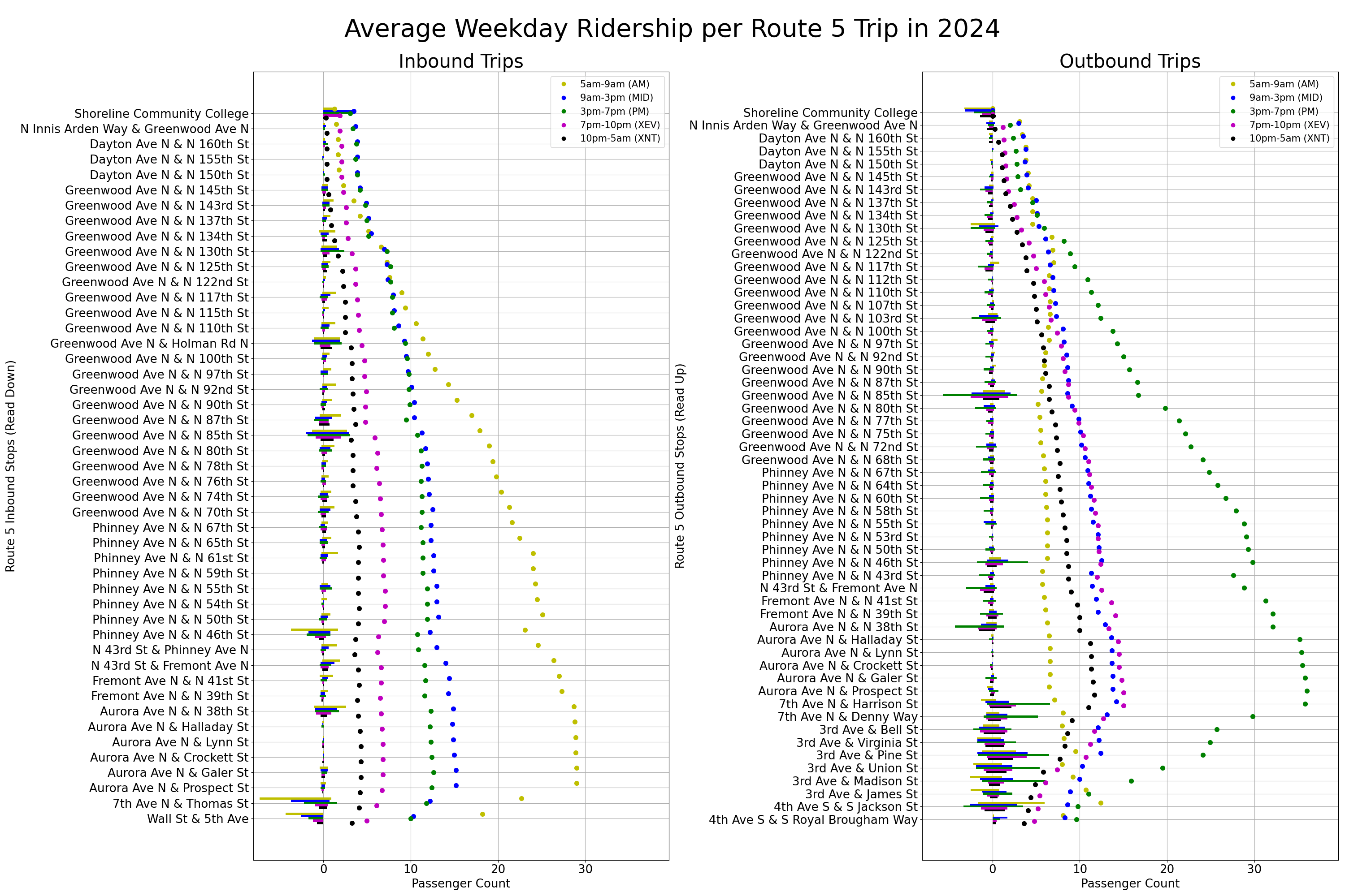
Outside of rush hour, most Route 5 stops have fairly low ridership. The busier stops include:
- Route 5’s northern terminus at Shoreline Community College is one of the busiest stops on the route. Many of the passengers boarding and alighting Route 5 here are likely students or employees at Shoreline CC. Some passengers may be transferring to/from routes 331 and 333. The area around Shoreline CC is primarily parks and single family homes. About 3-5 people board or alight each Route 5 trip at this stop in the mid-day and afternoon.
- In Bitter Lake, Route 5 stops at Greenwood Ave N & N 130th St. This stop is near several apartment buildings and the Broadview-Thomson K-8 School. Passengers can transfer here to Route 345. This stop has 2-4 passengers boarding inbound trips and alighting outbound trips all day.
- Route 5’s stop pair at Greenwood Ave N & Holman Rd N (inbound)/ N 103rd St (outbound) is surrounded by a few shops and restaurants, townhouses, and apartment buildings. Passengers traveling to Northgate or Ballard can transfer to Route 40 at this stop. About 2-3 passengers board each inbound trip throughout the day. Outbound trips drop off a similar number of passengers in the mid-day, afternoon, and evening.
- Route 5 stops in the center of Greenwood at Greenwood Ave and N 85th St. Greenwood has dozens of shops and restaurants, several apartment buildings, and lots of single family homes a block or two from the arterial streets. Routes 45 and 61 also stop here. About 3-5 passengers board inbound trips at this stop all day. Outbound trips in the afternoon have an average of 6 people alighting per trip.
- Between N 85th St and N 46th St, most stops have minimal ridership outside the peak direction. An exception to this is Route 5’s stop at Phinney Ave N and N 55th St, outside Woodland Park Zoo’s main entrance. Ridership at this stop peaks in the mid-day and afternoon in both directions, with 1-2 passengers boarding each inbound trip and departing each outbound trip.
- Just north of Fremont, Route 5 intersects with Route 44 at N 46th St. The area around this stop is primarily single family homes with a few townhouses. The ridership patterns suggests most passengers boarding and alighting Route 5 here are transferring to/from Route 44. Inbound trip primarily drop off passengers here, especially in the morning. Outbound trips primarily pick up passengers, with a significant increase in the afternoon. This data, along with the ridership patterns for Route 44, suggests some passengers transfer from inbound Route 5 trips to inbound Route 44 trips in the morning and from outbound Route 44 trips to outbound Route 5 trips in the afternoon (eg: commuting from Phinney Ridge to UW).
- On the north end of the Aurora Bridge, Route 5 stops at N 38th St. This stop pair provides an express option to downtown Seattle from Fremont. About 2-5 passengers board each inbound trip and depart each outbound trip. Route 28 also stops here.
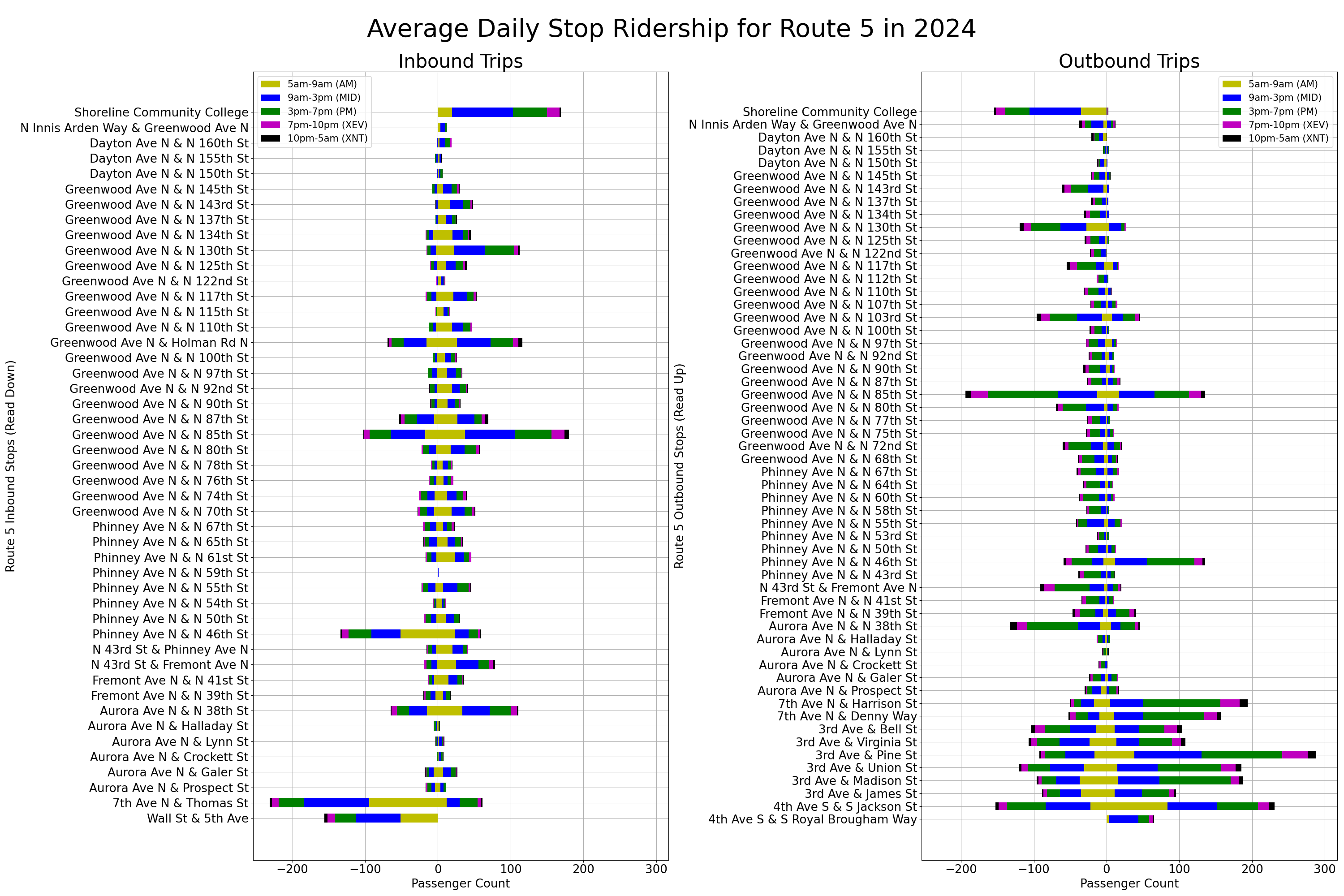
Daily Totals per Stop
The daily totals further show how the surrounding land use impacts a stop’s ridership. Stops near shops and restaurants, apartments, and other bus routes have much higher ridership than stops surrounded by single family homes.
Looking Ahead
Route 5 is a historic route that will continue running for many years to come. However, significant transit improvements will likely be focused on Route 5’s neighbor, the RapidRide E Line. Both Route 5 and the E Line run on Aurora Ave south of the Aurora Bridge. As a result, Route 5 is benefiting from the bus-only lanes along this segment.

We can’t talk about route 5 without also talking about the lack of east/west service to Phinney Ridge. Just the other day, I was making a trip between there and the U Village. 15 minutes by car, 15-20 minutes by ebike, 50+ minutes by transit.
Why does the bus take so long for a trip so short? It’s not just needing to transfer, but also, the two seat option (31/32-5) detours substantially out of the way, with the most direct route being the three seat variant where you transfer to the 44 in the U district. Two transfers to go four miles is awful, but the two seat option, due to going out of the way, isn’t any better. The bus is so slow, even going on foot the entire way, with a half walk, half jog, is still faster.
And, of course, if you’re doing it on an evening or weekend, when the 5 is only running every 20 minutes (or, 30 minutes if it’s Sunday), it’s worse. (As the chart shows, rush hour is when the riders are, and if you want to get around at a time when the bus isn’t full, be prepared to wait).
Green lake and Woodland Park are major impediments to E-W service across Phinney. 65th could use some E-W service, but it would probably need to be Ballard-Northgate.
I’ve thought that the 44 should swing to U Village-Husky Stadium, or just go straight to Seattle Children’s, but maybe wire is a blocker there.
It really shouldn’t, modern Trolleybuses can handle the distance out to Children’s due to their onboard batteries and In-Motion Charging.
“65th could use some E-W service, but it would probably need to be Ballard-Northgate.”
Based on past threads on this topic, the most plausible route would be a future extension to route 61. But, to avoid the sharp turn between Greenwood and 65th, it would need to bypass Phinney Ridge, so it still wouldn’t really solve the problem.
I personally find the argument that the turn is too sharp, therefore we can’t have transit service, lazy thinking. Surely, there would exist some combination of smaller buses and/or street improvements that could make it work. But, then you get into the root problem, where the cost per service hour keeps going up faster than inflation, rendering service like this impossible to afford to operate.
The segment of 65th on the east side of Phinney Ave is the big blocker there. It’s intensely steep and narrow and in particular, I don’t think the breakover angle for our low-floor buses could clear it. The Google Street View makes it look a lot less steep than it actually is, but if you walk or drive past, it’s INTENSE.
ctishman, YES, that hill is San Francisco-steep, like The Counter-Balance on Morth Queen Anne. Buses do run there, but they have no other way off the top of the hill except the connection at Boston to Fifth North.
There isn’t enough demand between the top of Phinney Ridge and Green Lake for Metro to risk running buses up and down such a grade, even if they could make the vertical transitions.
Even if there was an east-west bus all the way across 65th it wouldn’t completely solve the problem. You still have a pretty big gap between 65th and 85th. I would definitely like to see a bus go east-west but it wouldn’t create an ideal grid (it would just get us closer to it).
In this particular case, I don’t see how it would help. Imagine a bus running like this. Great. But now go back to the original issue. You are in the U-Village so you head … north? You are looking at a three-seat ride, the very thing the author is trying to avoid.
The only way I see it working is if this new bus continues east (to Sand Point). But if you are going to create an east-west bus, wouldn’t it be the 45? I suppose you do both but that seems like overkill. You could also have one bus serving 75th but that bus would have to dip down to cover Roosevelt Station. This means you are still overlapping much of the way. I just don’t see it.
But yeah, the big issue with an east-west bus is Phinney & 65th. It seems awfully narrow in there. I would still like to see the subject studied though. Maybe it wouldn’t be that bad. But then there is the service hours. A new bus would require extra money and I don’t see how we pay for it.
Even if we did add a bus on 65th, I think some three-seat rides are inevitable. They are quite common with Link. There are definitely areas where they can (and should be) eliminated. Buses like the 61 and RapidRide D end before they should. This means a trip like this or this. Even for the 5 a simple trip requires a long walk or two transfers. This sort of thing can be solved without adding brand new routes (on pathways that may not be feasible) or sending the 44 to Children’s Hospital.
But the problem is also mitigated by improved frequency. Short 3-seat rides are fairly common with Link. But it isn’t bad since Link is fairly frequent. It is about to become a lot more frequent (in the north end) which will really help with trips like that. If the 44 was a lot more frequent (and it should be) then the trip you mentioned wouldn’t be so bad.
Maybe the Phinney/65th turn would be possible with a couplet? Southbound a slight right to continue on Greenwood, then a wide right from the left lane onto 65th; northbound a left from 65th to Phinney.
I think there are a couple issues. One is the three-seat nature of the trip. There could be more of a grid with the 44 extending to Children’s Hospital and the 31/32 doing what it used to do (and stay south). But that introduces other issues. Part of the problem is that there aren’t enough Link stations in the U-District. If there was a station at Campus Parkway & Brooklyn then the connection between Link and Fremont would be as good (if not better) than it is now by sending the 31/32 there. But without the station it means the 31/32 has to go quite a ways further to connect to Link (at UW Station). There are issues with the 44 as well. You introduce new three-seat rides, including ones quite similar to the one you experienced. From Phinney Ridge you end up taking the 5, then the 44 and then some other bus to get to the south end of the U-District. You could take the 31/32 of course. That looks good on paper (it looks like a normal grid) but the 31/32 is not as fast as the 44 (even though the 44 is slower than it should be). You also have an awkward transfer between the 31/32 and the 5.
That is your other point. Should the 5 even get on Aurora? I can see it both ways. On the one hand it does mean riders get an express to downtown (just like riders of the RapidRide E). But you lose the connection to Fremont which means you lose the connection to other buses (31/32, 40, 62). In the case of the buses, the assumption is that the bulk of the destinations are served well by the 44. For example the 40 serves Ballard, the 62 serves Wallingford, the 31/32 serves the UW. But the 44 serves all of those places. Might as well get off the bus sooner and take a shortcut.
Basically, Metro is playing the odds and assuming that not many people are taking the trip you took. Way more people from Phinney Ridge (and elsewhere) are headed to the south end of campus then the U-Village. Not that many people on the 5 are headed to Lower Fremont and not that many would transfer to a bus there. They much prefer the express to downtown. Sending the 5 across the Fremont Bridge or the 44 to Children’s Hospital both seem like reasonable ideas. But there are plenty of trade-offs and the current routing doesn’t seem obviously flawed (unlike some parts of the city).
There is also something really interesting about the trip you took. It works well with bikeshare. Ride from U-Village to Fremont on the Burke Gilman. Then park close to the bus stop. Even if we had docks (which most cities our size have) there would bound to be a docking station nearby. At worst you walk a couple blocks to the bus stop. Then you take the 5 and you are there fairly quickly. We have that, it is just more expensive than most because we basically turned it all over to the free market (and gave up on a docking system).
The 44 and 31/32 could just both go to Children’s. The 44’s route through campus is fine but more duplicative and winding than just going straight down 45th. The routes through UW campus should probably get reorganized to form more coherent corridors.
The 44 and 31/32 could just both go to Children’s.
Yeah, that is probably the way I would do it. But you may introduce more three-seat rides than you eliminate. Just by looking at the numbers, it appears to be a wash. I agree, the route of the 44 is more duplicative. People traveling along that corridor would still have plenty of other buses to choose from (48, 255, 271 and 542). In general I see more value in sending the buses from the East Side (and certainly the 48) up to 45th (via that corridor) than I do sending the 44 along it. You gain more by sending the 44 to Children’s. The 31/32 is OK but it isn’t that frequent for as many riders are making that trip.
I think the biggest concern is traffic. There has been a lot of work done to avoid congestion for the 44 as it makes its way from the U-District Station to the UW Station. The other buses can take advantage of that (which is great) but what 45th? If traffic is bad through there then should we send another bus into it? (Especially since that bus is as vital as the 44.) I think we want BAT lanes along there before I would send the 44 to Children’s.
The routes through UW campus should probably get reorganized to form more coherent corridors.
Yeah, and that is a complicated subject. There are both long term and short term issues. At the risk of drifting too far off subject, I would do the following long term:
1) Extend the RapidRide J up to 67th & Roosevelt (via the Roosevelt couplet). This would be the only bus on Roosevelt.
2) Create a spine using Roosevelt/Ravenna/University (https://maps.app.goo.gl/ftkM4sqKUgpjVqPR7). This means the 48 would turn on Roosevelt. It would be joined by the 67 and future 77.
3) Continue to send the 48 and East Side buses on their current pathway between the UW and U-District stations.
4) Consolidate service within the UW Campus. The eastbound 65 is an unnecessary oddball. It should run on Stevens Way/Pend Oreille like the rest of the buses (including the same bus heading the other direction).
5) Once 45th is faster, send the 44 to Children’s Hospital (along with the 31/32).
There would still be some awkward transfers but I think solving them would be difficult and might cause more problems then it fixes.
Can the ave handle more bus traffic? It’s pretty slow and narrow. 15th would be much faster, though that is unfortunately a block further from U District station.
Yeah the 65’s couplet through campus seems really bad; I don’t understand why it does that.
Since fall 2021, routes 45 and 75 have been paired; so, a Route 5 rider could transfer at North 85th Street to routes 45-75 and reach U Village. The combination routes 5 and 44 would reach the U District and routes 31-32. I fear that the pairing will be ended with the next phase of Lynnwood Link. Instead, routes 75 and 77 will be paired.
Route 5 has history. Its pathway was served by the Interurban until the 1930s. Between 1940 and 1963, it was an electric trolleybus route and probably had shorter headway and waits.
In the 1990s, Route 5 had two variants. The SCC variant was 30/30/30/30/30 headway; a Northgate variant had the same headway but no Sunday service. Also, in the 1990s, the pathway in the north CBD was streamlined and shifted to 3rd Avenue. In fall 2012, lines C and D and Route 40 were implemented. Route 5 had been paired with routes 54 and 55; those two were largely absorbed by the C Line. Route 5 was paired with Route 21 and the latter improved to 15-minute headway. in the north, the two variants were consolidated on the SCC variant. The Northgate variant was absorbed by new Route 40. The Route 75 extension to Ballard was deleted. The transfer to/from the northbound Route 5 from Route 40 at North 105th Street remains awkward.
In fall 2020, when Seattle pulled its hours from funding the split of lines C and D, the Saturday headway of routes 5 and 21 was lengthened to 20 minutes from 15. Sad.
That’s a problem for the entire part of north and northwest Seattle between 45th/Market and 85th. I had a friend at 70th I visited occasionally and I felt like I wouldn’t want to live there.
This is where higher frequency and faster thoroughput could mitigate the issue of a 2- or 3-seat ride.
This is where higher frequency and faster thoroughput could mitigate the issue of a 2- or 3-seat ride.
And better routing. I don’t see the 44 as fundamentally flawed. You could send the 44 to Children’s Hospital but then other riders have a three-seat ride. As I wrote up above that is a fair trade-off (I could see going either way).
But I think there are clear routing flaws with both the RapidRide D and the 61. In both cases they travel east-west (or start traveling east-west) and then end. As a result, they don’t make enough connections (see the three examples I mentioned up above this, this or this). There are remedies that can be taken step by step:
1) Send the 61 to the Holman Road QFC layover (used by the RapidRide D and 28). That would improve the connection between the 61 and D.
2) Extend the D to Northgate via the current routing of the 40. Send the 40 to Greenwood and end where the 61 ends. At this point you have made most of the connections. The 5 and 61 are connected to the 40 and D. But you still have some missing connections. Which leads to:
3) Combine the new 40 with the 61. This would probably be too long so you would have to split this somewhere else. Splitting the 40/61 at it’s westernmost point (Ballard) and overlapping there reduces overall transfers. That’s because the bus goes out to the west and then comes back. For example a combined 40/61 would serve both Greenwood and Fremont. But riders aren’t likely to take that bus between them. They would just take the 5. Same goes for every north-south trip. At worse you have one transfer (not two).
RossB
Yes, Route 44 has a good pathway. The next step could be 10-minute headway in all time periods.
Regarding the pathways of the D line and routes 40 and 61. The latter has a live loop in Greenwood; there is no layover available; due to the traffic circles on 90th streets, it uses 35-foot buses, so it is not appropriate for Route 40.
We did discuss sending the D line to Northgate station via the route 40 pathway and sending Route 40 to Northgate station via the route 61 pathway. Route 61 could go to Northwest hospital. Route 45 would have to change. The D line extension, as branded, would require more red buses and capital. So, no such change soon.
I didn’t realize the 61 did a live loop in Greenwood. I seem to remember the old 5 Express laying over somewhere in there.
Swapping the 40 and D makes the system more efficient. You avoid overlap on Holman Road. But otherwise you are just swapping one set of transfers for another. Lake City to Greenwood goes back to being a two-seat ride. This means Lake City to Phinney Ridge goes back to being a three-seat ride. It is a step in the right direction (you can run buses more often) but you still have too many transfers.
In contrast, ending in Ballard eliminates them. From an east-west standpoint, greater Ballard is a dead-end. There is no reason to go that far west unless you are going to Ballard itself. Thus the only drawback is some overlap. If the bus from the north ends up in south Ballard and the bus from the south ends up in north Ballard you have minimized transfers. I think that is the best option, although it costs extra money. I would get the savings elsewhere (e. g. sending the 348 to the U-District) but that’s another discussion.
The several times I’ve taken the 40 to Ballard from Northgate, about half the 40 passengers transferred to the D at the first opportunity. I think some sort of limited stop Northgate – Ballard route would be really popular.
I think some sort of limited stop Northgate – Ballard route would be really popular.
But as mentioned above, there are issues with that. See step 2 above. Just doing that requires a lot more money. Not for service but for new red buses and fancy new “stations” to support the new route of the D. That is basically the first step. That is an improvement but it still leaves you with a lot of transfers, including new ones (Greenwood to Lake City) and new double transfers (Phinney Ridge to Lake City). You really want step 3.
But step 3 is not trivial either, even after you have done all that work. You are basically combining the new 40 with the 61 and then splitting it somewhere. There are no existing layovers along the way, so you have to use other ones. It is inevitable that you overlap — it is just a matter of where. Consider some possibilities:
1) Both routes end at the locks. Unfortunately this means a lot of existing riders have to transfer (e. g. 65th & 24th to downtown).
2) Both routes end in Sunset Hill. This means there is no one-seat ride from Greenwood, Northgate or Lake City to the main part of Ballard.
3) The route coming from downtown ends in Sunset Hill while the route from Lake City ends in the locks. This is ideal from a rider standpoint but you added a lot more service.
I’m not sure why any of the routes would be limited stop. That really wouldn’t save you much. Overall, as much as I would like to see it, I don’t think it is feasible without a major restructure *and* additional funding (especially for the RapidRide work). In contrast I think you can achieve quite a bit by simply extending the 61 to Crown Hill. This would cost money, but not a lot. It would not be a major change, either. I don’t think it is plausible now but I think it is possible after we pass the next transit levy (assuming a more progressive council will support more funding).
Sure, if you made it RapidRide it’d cost a lot to implement.
The 40 seems to have a mixture of shorter distance passengers and those traveling longer distances. I wouldn’t want to completely get rid of a number if the stops.
A limited stop overlay, maybe calling it a 41 or something, and operating it all day, wouldn’t require as much investment. I think you could get away with a different routing near Northgate, so this new route wouldn’t have to loop back north.
Or, extend the D, keep the 40, and only give the D 5 stops or so between its current end and Northgate? That makes the express stops clear, but prevents having to build dozens of them, so a bit cheaper.
“The route coming from downtown ends in Sunset Hill while the route from Lake City ends in the locks. This is ideal from a rider standpoint but you added a lot more service.”
A bit of overservice would help mitigate the decades of underservice throughout Metro.
I don’t know why you’re saying “the locks” and “Sunset Hill”. I think of it as Market Street and 85th. I don’t see the northern route turning west to the locks where ridership is lower. And “Sunset Hill” doesn’t say where in Sunset Hill. The former 75 alignment laid over about two blocks south of Market Street near Leary Way. The other layover could be where the 48 lays over now.
The overlap would be only 1 1/2 miles, so not that expensive. It much more important to get a route from Lake City and Greenwood to get to the center of Ballard than it is to avoid overlap. You need to connect major urban villages to each other, not have routes that go from one and terminate just short of the other. There’s probably no way to avoid overlap, given that routes like the D and 40 would still be necessary.
@Ross, yes, the 5 Express turned around in Greenwood on the exact same loop the 61 uses today. Not sure whether it laid over there though? The 355 covered north Greenwood Avenue, and then cut over on 85th to I-5 and go downtown with one stop in the U-District.
I don’t know why you’re saying “the locks” and “Sunset Hill”.
It is shorthand for the existing layover locations. It also means I don’t have to look up the address :)
Anyway, “the locks” is shorthand for 32nd Avenue NW & Market. “Sunset Hill” is shorthand for 32nd Avenue NW and NW 85th Street.
Sure, if you made it RapidRide it’d cost a lot to implement.
You pretty much have to if you want a good network. The RapidRide D is both redundant and stops short. It is a big part of the problem.
Or, extend the D, keep the 40, and only give the D 5 stops or so between its current end and Northgate? That makes the express stops clear, but prevents having to build dozens of them, so a bit cheaper.
That would be more expensive, not less. You would be duplicating service on the slower pathway (the 40). Meanwhile the fast way to get from Northgate to Ballard (via 85th) would still require two transfers. Sorry, but that just doesn’t work.
A limited stop overlay, maybe calling it a 41 or something, and operating it all day, wouldn’t require as much investment.
But it would still be costly. You have to come up with extra service money for the new route or extension. The cheapest would be the 61. So now instead of ending in Greenwood it ends in Ballard. That requires more money, no matter which stops you use. It isn’t clear which stops you would skip, either. Ridership is pretty well spread out in the area. You also make it difficult to improve headways by combining service. If you have two routes on the same corridor and they have the same frequency you can combine them for good headways. For example the 45 and 61 can provide combined 7.5 minute frequency for trips along 85th. That isn’t possible if one bus is skipping stops (and therefore significantly faster). You are more likely to have bunching which means that riders don’t benefit as much.
It is basically the same plan, just without changing the D Line or 40. It means the D Line does not connect to 5 or E Line (one of the major drawbacks to the route). The D Line also doesn’t connect to Northgate. Yet the D Line manages to overlap the 40 in Holman Road.
Now consider taking that 61 extension but doing some other work. Extend the D to Northgate (via the current pathway of the 40). Have the 40 go west as it reaches 85th (laying over with the 45). From a service standpoint, this doesn’t cost a dime. It may actually save money. But even though this is basically free you have a lot more connections. The D connects to the 5, E, Link and all the buses that layover at the Northgate Transit Center. That is a big improvement for the network.
So you can think of it this way: Extending the 61 to Ballard requires extra service money. You can save some money by making it skip some stops but I don’t think it is worth it (it would still cost extra). Once you extend the 61, shifting the 40 and D Line around costs nothing in terms of service, it just requires new bus stops and more of the special RapidRide buses.
This is why I think it would be a big project. Changing the routes in this manner is not minimal and not cheap (from a service or capital standpoint). It would be worth it — it would make travel much, much better in northwest Seattle — but it qualifies as a “Big Change”. In contrast, extending the 61 to 15th does not. It still requires extra service money but is even then, not a lot. It would be a good first step, but we would still want to eventually do more (especially with the RapidRide D).
The former 75 alignment laid over about two blocks south of Market Street near Leary Way.
That would save some money. I just went with current layovers (of the 44 and 45).
There’s probably no way to avoid overlap
I agree. But the more overlap the less frequency. It is the inherit trade-off. But in the case of Ballard I think it is worth it. As you pointed out, I don’t think it is an excessive amount, either. I also think they are solid corridors. Riders can benefit from the doubling (like they do with the 3/4 in Cherry Hill). My guess is 24th NW is a pretty cost effective pathway. It has plenty of people but not that much traffic. It seems relatively fast. It also looks like a street that could someday have BAT lanes without much effort. It also has a solid anchor if you will (Ballard). It seems like plenty of people would take advantage of the double frequency along there.
In contrast I don’t think you get much out of the 40/D overlap. Only a handful of people ride the D for that section. The frequencies don’t match, either. Extending the D (and having it take over that part of the 40) would be much better (and eliminate that overlap).
There would continue to be overlapping on 85th and for the most part I also consider that a good thing. But 85th peters out towards the west. Then again, ridership at the end of the 45 (at 32nd & 85th) is quite good (about 100 riders a day). You could send the 45 to the current layover for the D but it might not be worth it. I actually like the idea of having several overlapping fifteen minute buses providing really good frequency. It is a stretch with today’s budget but with more money it wouldn’t e. The D would be the only bus in the area without much overlap but that’s fine given its higher frequency.
The only drawback to setting frequency in this manner is that you create dependencies. The new 40 and 61 would overlap on 24th. The 45 and 61 overlap on 85th. That means all three are tied together. Increase frequency on one and you want to increase frequency on all of them. I am OK with that — they all seem like they are similar — but it limits flexibility (or you end up losing effective frequency along a corridor).
61 should be extended further west.
Yes, absolutely. I said the same thing up above (and had some other ideas): https://seattletransitblog.com/2025/09/29/ridership-patterns-for-king-county-metro-route-5/#comment-967314.
We said that in all our feedback to Metro during the restructure, that the 61 should go all the way to the Ballard urban village. People are trying to get from Lake City to Ballard, Northgate to Ballard, or Geenwood to Ballard, not have the route peter out in an almost-empty residential area. 90% of the destinations are in central Ballard. Only people who live in the houses on NW 85th and their guests are going there, and that’s not many people.
But Metro was trying to stretch the budget during a driver shortage and recession. It first offered the 61, then withdrew it saying it couldn’t afford it, then reinstated it because of the outcry for service on Lake City Way/NE Northgate Way and the continuing calls to connect Northgate to N 85th St. That’s presumably the reason the 61 just ends in the middle of nowhere.
The 61 should be extended west but it most certainly doesn’t end in the middle of nowhere. It ends in the Greenwood neighborhood, one of the more urban areas in Seattle. There is plenty of retail there as well as a lot of apartments (and more on the way). A lot of the development in Seattle is along the corridors. This includes 85th as well as Greenwood Avenue. Thus by turning around at that intersection it covers that dense neighborhood. If anything the RapidRide D ends at an areas with fewer people.
But in both cases the problem is that the buses don’t connect to other buses. If the 61 could turn around at 85th & 15th it would connect to three more buses (the D, 28 and 40) which means it would connect to all the buses in the area. I’m not sure the best way to do that. I think the simplest would be to take a left on 8th, then rights on 80th, 15th and 85th. There are traffic lights for every intersection, including a left turn arrow for the one left turn (from westbound 85th to southbound 8th. There is already a bus stop on 8th (south of 85th) that the bus could use. Likewise there are bus stops on 15th and 85th. You might want to add a stop or two on 8th (at a minimum I would add one close to 80th since the existing stop on 8th is south of the intersection).
Depending on which direction the bus is going, the transfers would be interesting. If a riders is coming or going from the south it would look like this:
40 to 61 — Cross 85th on the east side of the street
61 to 40 — Cross both 85th and 15th*
D to 61 — Same stop transfer (the best of all transfers)
61 to D — Cross both 80th and 15th
28 to 61 — Round the corner from 8th to 85th (don’t cross the street)
61 to 8 — Same stop transfer.
*This would be the most annoying transfer as you have to wait for the bus to go south and then back north before connecting to the 40.
As much as I would like to restructure buses and connect them in a more efficient manner I think this is the best we can do in the short term. This doesn’t require an extension of a RapidRide bus (which is expensive because it is RapidRide). This is just a simple extension of a normal bus. Not counting the stops, that adds about five minutes to the turnaround. We would have to come up with money for that but not a lot.
I’ve taken the 5 a few times and it could really use some stop consolidation. The bus is constantly starting and stopping as it travels from Fremont to Greenwood. There are stops in the same direction that are literally on the same block as each other.
Stop consolidation and some bulbs would do a huge amount of good for the 5, which still has very solid ridership despite how much is siphoned off by the faster E Line. SDOT needs to replicate what it did to Greenwood north of 90th on the rest of the street, which would help the bike lane situation a ton too.
Its other major issue is the occasional backups on Fremont getting onto the bridge, which can add several minutes to the trip.
yes, bus bulbs should be provided north of North 105th Street. South of North 85th Street, Phinney-Greenwood was reduced to a three-lane profile. With significant cost, they could be “Dexterized”, with the PBL against the curbs and transit islands provided. Without Dexterization, buses and bikes weave. In the peak periods, there are long queues in all four directions behind the signal in downtown Greenwood for routes 5, 45, and 61.
In the peak periods, there are long queues in all four directions behind the signal in downtown Greenwood for routes 5, 45, and 61.
There should be BAT lanes for all of 85th as well as most of Greenwood. Greenwood is trickier because they put the bike lanes there (oops). But there is still an excess amount of parking. If nothing else there should be BAT lanes going one direction or another.
Metro is looking into this (https://kingcountymetro.blog/2023/08/21/improving-the-reliability-of-the-route-5-metro-studying-transit-improvements-for-popular-service/). I haven’t heard any updates. But stop consolidation is certainly part of it.
Good point DH, about Fremont Avenue backups (due to the bridge opening). Unfortunately, as this article (https://www.theurbanist.org/2023/09/05/metro-looks-at-speeding-up-route-5/) pointed out, “no dedicated bus lanes are proposed in this area”. They may not need them through there. The bus turns left and they will be adding a left turn lane. That may be enough. If it isn’t, they should add BAT lanes north of there. I understand that they want to have bike lanes on both sides. But it seems like the street is wide enough to accommodate those as well as a southbound BAT lane.
Once you get up the hill I think they should add more BAT lanes and shift the bike lanes to other streets. It isn’t hard to find routes for the bikes a block over that could work just as well. With some work those end up being much better. Not only is travel along the side street safer but the crossing of busy streets (like 80th and 85th) are much better as well. Of course if you can squeeze in BAT lanes and bike lanes, you might as well. It is just that too often we build half-ass bike infrastructure because we insist on following the bus corridor. Then the bus infrastructure becomes half-ass as well.
I don’t think it has to do with the bridge opening actually, when I bike in I’ve never seen a queue south of 34th. It seems to mostly be traffic on the Aurora bridge that backs up down the diagonal section of Fremont Way, and occasionally all the way past BF Day (as well as the Route 40 construction). Other issues are backups at each light which can get quite long sometimes, queue jumps and TSP would probably relieve those to some extent.
They could definitely improve the stay healthy network in the area to give alternate bike routes, but there should be plenty of room to drop the center turn lane and go to parking protected bike lanes as well.
It seems to mostly be traffic on the Aurora bridge that backs up down the diagonal section of Fremont Way, and occasionally all the way past BF Day (as well as the Route 40 construction). Other issues are backups at each light which can get quite long sometimes, queue jumps and TSP would probably relieve those to some extent.
Agreed. That is the type of thing they will end up doing in that area (I think).
there should be plenty of room to drop the center turn lane and go to parking protected bike lanes as well.
If they got rid of the center turn lane as well as parking then maybe they could have both bike and bus lanes (both directions) but it would be tight. It is basically five lanes wide. So both directions you could have a bike lane, a BAT lane and a general purpose lane (bike lanes only need half a lane). It does look wide enough, especially since the parking lanes are pretty wide. So yeah, that could work.
Of course you would get criticism from both local business owners and people who live nearby. More people parking in the local neighborhood. Harder to turn into the parking lot.
Meanwhile, it would still be less than ideal for bikes. Crossing 80th and 85th is bound to be nasty on an arterial like Greenwood. In contrast if you added bike lanes on First Avenue NW you could also restrict automobile travel in both of those intersections. Treat the intersection like 92nd & Aurora. Prevent cars from turning left onto the street or going straight on 1st. That is fundamentally safer. Not only for the big crossings but along the pathway (there are fewer cars and they go slower).
It is not a perfect corridor because it requires periodic doglegs. You want to stay close to the main corridor (because it has more apartments and businesses). So something like this. On the other side you would use Fremont Avenue (which already has some improvements and connects well to the Interurban). The only tricky part is connecting upper and lower Fremont which is why using Fremont Avenue is fine (especially since the 5 turns).
A bit off topic but I think one of the big things the area needs is a good connection from Licton Springs to Green Lake. I can get from Pinehurst (where I live) to Greenwood just fine on a bike using paths that are quite safe. Note: It is actually safer and more direct than Google shows — I bike through the Northgate mall which is easy (for some reason it doesn’t realize there is a crosswalk with a beg button at Third & Northgate Way). But getting to Green Lake is much harder. Here is the section from Licton Springs. Notice how it sends me via Wallingford Avenue. This sucks. But the alternatives suck as well. I guess I could go all the way over to Stone Way and back but that is about it. They should make Ashworth a bike street with the same sort of treatment (add a beg button, bikes can go straight but cars can’t, etc.).
I don’t think removing the center turn lane is realistic. There are a lot of driveways and side streets off the entire Greenwood corridor.
Greenwood is pretty steep on both sides, it’s not easy to get on/off the corridor by bike. The street happens to drop down to a low point at 85th; perhaps a bike lane uphill and a shared bus/bike/right turn lane downhill could work to get bus priority in both directions at that intersection
The STP also has the “Bike+” corridor ending at 73rd; perhaps that gives more space for transit priority north of that.
https://seattlecitygis.maps.arcgis.com/apps/instant/basic/index.html?appid=5150950f95e64594b36c278ef17d9f3f
I don’t think removing the center turn lane is realistic. There are a lot of driveways and side streets off the entire Greenwood corridor.
Yes, that is the local opposition I mentioned. Basically folks don’t want to have to approach the parking spot from the other direction (oh, the horror!).
Greenwood is pretty steep on both sides, it’s not easy to get on/off the corridor by bike.
It depends on where you are. Some times it is practically flat. For the route I mentioned the only bad part is just north of Ken’s Market (and even that isn’t that bad). The main thing is that it is close to the main corridor. This means that it usually isn’t very steep* and if you end up walking your bike it is a short walk. It would only be a big issue if you were continuing your journey and this blocks the way. But I don’t see that as being a big issue. There are plenty of places where you can cross and it is pretty flat. It isn’t like the issue I mentioned in that other comment. That is several blocks of travel that are terrible for biking. It is its own little “missing link”.
*It also helps that you are west of the corridor. To the east (just north of the zoo) is where it drops off quickly. Fremont is a great corridor but it slowly goes downhill (from the Interurban) until 65th while the ridge stays fairly flat. South of 65th if you continue on Fremont you have to go up stairs before reaching the zoo. Relative to the Phinney/Greenwood plateau, 65th & Fremont is in a big hole.
Oh, and the map is pretty good in places but clearly flawed in others. It has the pathway I described (more or less). I would stay closer to the ridge. My point is once you build that up you don’t need bike lanes on the Phinney/Greenwood arterial. That seems like extra work for nothing. You are spreading yourself too thin while complicating the work that should be done to make the 5 faster. The same is true between Fremont Avenue and Greenwood Avenue. If you add bike infrastructure for 42nd, why do you also need it for 43rd (where the bus goes)?
It seems like Fremont Avenue is the only place where the bus and bike route should coexist. Just run the bike lanes up to the zoo (which is the plan) along with lanes on 50th. I suppose there isn’t much harm in continuing the bike lanes around the zoo and on the Phinney. But I would transition from bike lanes to bus lanes north of 60th (where it is flat if you are doglegging to Greenwood). That would mean someone biking from Fremont to Greenwood (or beyond) would go up Fremont, go around the zoo (via 50th and Phinney), take a left on 60th and a right on Greenwood. Or you could go straight up Greenwood the whole way. That is safer but steeper (although the same net elevation gain).
But the flaws there are nothing compared to what exists in the Haller Lake Area. They call 130th a “Premium Transit Corridor” (the highest level). So what do they do? Remove BAT lanes and make it slower. This is so 130th can be a “Bike+” arterial. But why not 128th? It would be much better for bikes as the crossing of Aurora would be much better. This would allow them to actually make 130th faster (not slower) for buses. My guess (as to why they screwed this up)? They came up with the bike plan before the transit plan and the transit plan changed. That, and the obsession with just running lanes on major arterials even when it is clearly worse for riders. Obviously you are bound to have overlap 1st and 5th (you have to get over the freeway). But at that point I would much rather dogleg to 128th, especially if I’m heading past Aurora (which would likely be the case for most riders). Or maybe they are just OK with half-ass bike solutions. 128th would require some work. You would need a new crossing of Aurora (with a beg light). You would need to add asphalt here and there. In contrast they just add some paint on 130th and it is good to go. It is a lot more dangerous than it should be, but it is officially a bike path.
The 5 performs well as one would expect. It has decent density (of all types) pretty much along the entire route. But you can really see how important the transfers are. They really stand out. Shoreline Community College may be only outlier. It also works as a transfer point but my guess is the vast majority of riders are simply going to the college. Greenwood & 130th surprises me. The 345 is not that frequent. But about 50 riders a day use that stop. So the transfer (along with the general density and the nearby library) may be enough for that bus stop to stand out. The other bus stops with high ridership have big-time crossing routes. It just shows how important the network is. If we can run the crossing buses more often then ridership of the 5 would go up (and vice-versa).
As someone who used to live in shoreline, I occasionally take Rt 5 in the evening to avoid the E Line as that route is known for being one of metros more dangerous routes for both what happens on the bus and the areas it travels through, especially late evening/early morning.
I have a long thought that there should be an extension to the 5 late at night to connect Riders to Aurora Village so they don’t either have to walk over to the E Line or it coming from downtown take the E at all. I also feel like this extension could include but not be limited to additional late night service in parts of Shoreline like along the 331s corridor which we know from past routes that you used to run along parts of that corridor the larger buses that Rt 5 uses can be used along this extended routing.
I understand this might facilitate separating the 21 from the 5 late at night but that is a connection that I don’t think as many people are trying to make late at night or early early in the morning, if it is still something then we could bring back kind of connections between different routes like we used to have with the old Night Owl Network.
A really good example could be that route 5 could have a timed connection to and from Route 21 while other routes that used to be connected at one point but are currently not connected could have their own time connections as well, take Route 7 and Route 49 as an example because they used to connect on all trips, formerly was one route, then only connected on evening trips and weekends, then evenings and Sundays only, now they don’t connect at all.
I believe that having Route 5 run all the way to Aurora Village starting at 10:00 p.m., 10:00 p.m. arrival at Shoreline college that is, would be better for bus layover and Driver accommodations due to the fact that the drivers have no comfort station accessible after the school closes, nor do they have access to a proper layover space and whenever an articulated bus is used on the route that late at night you run into them having to make u-turns outside of the college in which the bus could get stuck, I have witnessed the result of this at least one or two times but every time a bus has to make that u-turn you are in troducing this risk and the risk that the subsequent southbound trip won’t be operating.
Also shorelines considering putting in a new roundabout that would be utilized at the intersection of 160th Greenwood and Innis Arden where it’s not going to be a normal Circle but it sort of peanut shape in which it’s going to be harder for buses to loop around the roundabout and I have heard no talk about accommodating Route 5 with its articulated buses passing through the new roundabout.
I think looking at extending the route all the way to Aurora Village while figuring out a different way to connect students to the college could be a good solution with the new infrastructure once it is in place and we see how much it’s actually not going to be helpful to Route 5.
What is the latest plan for routes 67 and 75 after Pinehurst Station opens? Will at least one of those routes travel N/NW 130th St, over to Greenwood?
In Pinehurst station opens a few things are changing where the 372 is no longer going to exist as the 372 and instead is going to be running as the 72 which I believe is going to go to Shoreline South Via 145th Street from Lake City Way but other than that be the same as the 372 south of the intersection on Lake City way.
That’s for Pinehurst station a new Route 77 will crop up and that route will be from the University of Washington to Lake City via a combination of University way and roosevelt/12th Ave then out to Bitter Lake via 125th Street Pinehurst station and 130th Street. Route 77 will then terminate with a loop where the 28x used to terminate.
72 and 77 will not go online until Link light rail goes across the I-90 Floating Bridge, which should be early next year in like April. At that time the 5:22 will also make its shift to go to Shoreline South Station rather than Roosevelt station, hence the Route 77 creation.
What’s that means if you normally go from north of 125th down to the Roosevelt area either to get the 45 over to work somewhere in the Green Lake area or all the way over in the Greenwood area you may have to make changes to how you travel a little bit because you will need a third bus to make that trip.
Personally I wish the 77 was the one going to Shoreline South as that would facilitate a better connection to the 522 for riders coming out of Lake Forest Park and Kenmore who may need to go down towards the Roosevelt Station area.
I guess there wasn’t enough ridership for people making those particular trips that sending the 522 to Shoreline South would be a problem and so that is the decision that’s being made as the 522 will be mirroring STride S3 and I believe being kept around once the brt line is up and running as a local.
At that time that this change occurs and the 72 and 77 are created in the 522 is shifted the 65 will also gain its little kink in the route up near Crest High School plus I believe it will also drop to be every half hour north of Lake City every 15 minutes south of Lake City while the every 15 minutes 72 is still present.
It is weak. Routes 75, 345, and 365 ignore the station; they turn away from it. Route 77 serves it, but does not serve the four stops of Lake City hub; it would use 30th Avenue NE south of NE 125th Street. Routes 75 and 77 are to be paired via the U District; the implementation of routes 72, 75, and 77 may await the change to Route 522 and the 2 Line crossing the Lake.
Yeah, as Jack wrote, the plans are weak. Part of the reason Micheal wrote this is because I asked him to focus on several buses that I think should be altered with the Pinehurst Station. I don’t mention the (3)72 in that essay. I think it should be extended to Shoreline Community College (and take over the tail of the 333). That would be so much better for the vast majority of riders.
Shouldn’t Route 5 be the kind of route that runs 15-minute frequency on the weekend as well? If not Sunday, at least it deserves to be more frequent than 30-minute on Saturday I suppose.
It used to in 2019. But, when the Seattle supplemental funding got cut in half, something had to be cut, and route 5 weekends got the short end of the stick.
Yes, definitely.
East/west connectivity is a problem for transit in general. As a thought experiment, I asked Google for transit travel times between a bunch of random points in north Seattle east of 25th Ave. and west of Aurora. Nearly every single time, the trip took an hour or more, and even in rare cases where it could be done on a one-seat ride, it was still usually well over half an hour (these buses are not quick).
I don’t think it’s a reasonable expectation for most trips to be one-seat rides, but I do think it’s reasonable to expect two-seat rides that are frequent->frequent and don’t entail detouring out of the way to reach a connection point. All two often, two-seat rides in the real network involve significant detours, in some cases, with the detour sucking up just as much time as an additional transfer.
The area between the Ship Canal and the County Line is about eight miles long. There are some routes that do go from East of Aurora to east of 25th Ave NE but yes they can be slow.
Although double transfers are a hassle (especially without down escalators) but Link in North Seattle will have trains every 4-5 minutes next year. That’s almost no waiting (a bus can wait 2 minutes just to get a green light crossing Aurora and half the wait of a train every 4 minutes is also 2 minutes).
Sadly, big déterrants are the Link station depths at Roosevelt, U District and UW Stations. But once 2 Line is running the faster overall trip time will be mostly a function of feeder bus frequency involved with a double transfer rather than a slow bus route with a single transfer in many cases where the trip ends are at least 2 miles north-south of each other.
I’ve pointed out that some east-west buses could be more convenient with one or two colocated stops on Aurora (with RapidRide E). That way bus transfers don’t require crossing Aurora or a crossing arterial in many cases. It does make lane switching hard for drivers. It’s not a popular comment.
The issue here isn’t really Link – with trip endpoints east of Link and west of Link, it’s all buses. For transfers with Link you can deal with station depths by walking the escalators, rather than standing.
The issue here isn’t really Link – with trip endpoints east of Link and west of Link, it’s all buses.
But Al’s point (which is a good one) is that the buses are influenced by Link station location. Just to back up there, there are a lot of issues with east-west travel. Link is one. Another is the street grid. An ideal grid is about 600 meters apart (see David Marcus’ comment here: https://humantransit.org/2010/11/san-francisco-a-rational-stop-spacing-plan.html). Any closer to that and you overlap coverage. Any farther than that and you have coverage gaps. But assume that riders can walk a little farther and we put the lines 800 meters apart. Many of the north-south lines are about that (or a little bit less which is ideal). So in Ballard (NW) that is 32nd, 24th, 15th, 8th. Phinney Ridge is a bit wider and creates a bit of a gap. 3rd NW helps fill it. Things get messier close to Green Lake and the freeway but it is the same idea (Aurora, Meridian, Roosevelt, etc.).
But the real problem is with east-west routes. Again, if you look at Ballard, things are great at first. Market and 65th are ideally spaced. 75th would be good as well but it isn’t an arterial. Instead there is 80th and 85th. So already it doesn’t work well. Holman Road runs diagonal and when it does run east west it is 105th — quite a ways from 85th. Because of the hills and the freeway the streets actually go farther apart. By the time you are at 15th NE, Northgate Way and 75th are almost 3 kilometers apart (with no east-west road in between). You can go back and forth and pick up pieces but because of the freeway there are some big gaps. There just isn’t a good east-west street grid.
Then there is Link. The stop spacing and location makes things worse. The 31/32 is forced north or south to a Link station instead of doing the intuitive thing (head straight across to the campus). Then there is no station between Northgate Station and 65th despite crossings at 80th/85th and 92nd. Making matters worse, the Northgate Station is not on the main crossing street (Northgate Way). It isn’t on a crossing street at all! You can’t access the station from the west without going around. This makes it especially cumbersome.
As a result, you can’t make a good grid. You have to compromise. Either you live with three-seat rides or you overlap. Overlap leads to poor frequency. Ultimately you have to make trade-offs. In this case, Metro runs the 44 to the south end of the U-District instead of to Children’s Hospital. If asdf2 had started his journey there then the trip would be a straight-forward two-seat ride. I’m not saying the choice they made is the right one, but there are winners or losers no matter what. Someone is going to take a three-seat ride (or a slow two-seat ride, which is what asdf2 didn’t want to do).
I’ve pointed out that some east-west buses could be more convenient with one or two colocated stops on Aurora (with RapidRide E)
I agree. I think a lot of people in the planning community were surprised that the 333 isn’t doing what the old 330 did. It used to dogleg on Aurora, serving both 155th & 160th (https://www.kingcounty.gov/~/media/depts/metro/schedules/pdf/03212020/rt-330.pdf). Another place where I could see the same sort of thing is with Swift Blue. It should go down Aurora, stopping at 200th and 192nd before turning on 185th. If Metro has to pay Community Transit to make that happen, so be it. The 333 could also dogleg. It could run on Aurora between 175th and 160th. But then again, I don’t think the bus should run on 175th. There is very little on 175th other than at the the cross streets (that have other bus service). If it went across 185th it could head south and pick up everything between 185th and 160th. The only drawback to that route is that it means riders would be heading north to get to Link (when most riders are ultimately heading south). The future 77 is supposed to end at 143rd & Linden. This means it will effectively cover 130th and 145th.
So you could reduce a lot of three-seat rides this way. Then again, I can see a different approach. Basically live with two-seat rides to Link but solve the problem with added frequency. I think you end up focusing on a few corridors (to avoid spreading yourself too thin). Consider them going north. The first significant one is 45th (served by the 44). This serves a pretty big gap (between 85th and downtown) and is very strong route in its own right. If it ran very frequently (e. g. every 7.5 minutes) it would reduce the wait time for a lot of riders. 85th works with very little effort. Both the 61 and 45 can run every fifteen minutes which means you only have to time the buses to get 7.5 minute headways. Northgate Way is awkward as a transfer point (the 40 has to loop around to get to the station). 130th is an excellent transfer point. The corridor is very strong and traffic is relatively light. With 130th as the major crossing point I don’t think it makes sense to create very high frequency crossing routes to the north of there. It would be better to have 7.5 minute frequency on 130th then 10 minute frequency on both 130th and 145th. That’s because 130th can basically serve as the catchment place for everything to the north. Thus you would have three big crossing corridors (130th, 85th and 45th).
The two ideas aren’t contradictory. They actually complement each other. For riders up by 200th or 192nd a trip to 130th would take a while. But if Swift Blue served both both of those stops they would have another good option. If nothing else I would alter the 333 between 145th and Shoreline Community College. But money spent doglegging a lot of buses on Aurora might be better spent running more crossing buses.
So what would it take to make that happen? The big thing is to run the 44 a lot more often. This would take extra service money but eventually should happen. For 85th it just means timing the buses properly. For 130th it could mean running one bus quite often but the easier approach is to do something similar to 85th — have two buses (each running very 15 minutes) combine for 7.5 minute headways.
An awful lot of the east-west routes are awkwardly shaped, so they don’t really spend a lot of time going east-west. There are also an awful lot of dead ends that require backtracking, such as Shoreline CC, Northwest Hospital, and whatever the 345 is trying to serve at Linden & 134th. All that turning around and backtracking adds time.
Look, I know Seattle has obstacles and all that, but some of this is unnecessary.
I’m not saying not to serve these places, but it seems like the tangle that is such routes as the 345 could be made less tangled.
The 345 makes multiple loops to save a few feet of walking for people headed to one particular destination. This approach doesn’t scale, and it’s paid for not only with service hours, but also with the time of everyone who rides the bus through the area.
Another thing I don’t understand about the 345 is why it has to double back after northwest hospital to serve Haller Lake. It’s just a tiny cluster of houses already served by the 365. Taking 115th to Aurora to 125 would be faster.
You can’t run a transit system by picking out a handful of destinations and declaring them special, where people headed there, and only there, get front door service, at the cost of the time of everyone else on the bus.
The northwest hospital detour is especially egregious because it makes the bus wait in line with cars while drivers hand money to a cashier to pay for parking (I’ve been on it and I’ve seen it). Anytime a bus gets held up by drivers paying for parking, that is a sign that the bus route is really, really messed up.
The 130th stop could be getting some of the riders that used to ride the 28 on broadview. It is a long walk uphill, but metro thinks people would do it. (When metro put notices on the 28 stop saying the stop woulds would be closed and that people should ride the 5, somebody wrote on it that the suggested stop was almost a mile away )
130th is the nearest stop for a huge area – most of Broadview down to 12th and beyond. There is some dense housing, a nursing home and a school right there, along with the library that also contribute.
I would love to see a bus continue down 130th to do the “Broadview loop” that the 28 used to do (125th/8th/132nd). This would open up unserved areas without long duplicative bits.
I’ve had Google give me transit directions from Broadview to bitter lake that are slower than walking. The 345 is usually part of the route, but it is slow. However, it does serve many places. There are a lot of ingraham students that ride it, especially from 130th and greenwood to Ashworth. It would be great to have better bus service to allow more students to bus to school .
As for bike/bus routes, the problem is that the arterials are the best routes and that there are few alternatives that don’t entail significant detours, steep hills or both. 130th is the only direct option that takes you from Broadview to the other side of the freeway. With two lakes in the way and only one freeway crossing, the choices are limited. 128th is ok from haller lake, but your still going to end up back on 130th to cross I5 and aurora (as well as greenwood and 3rd).
Greenwood is similar in that other bike routes have issues. A detour to Fremont north of 65th involves some steep hills. This also connects to interurban trail. Going west to 1st is ok. However this still requires you to detour back up to greenwood or 3rd to cross Holman. It is much more effecient just to continue on greenwood.
Yes, the 28 used to cover Broadview. You can see it on this old map. That was peak only before they cut it (I don’t know if it was ever full time). Still, ridership on the 5 likely went up a bit when they canceled that tail.
But I don’t think the stop at 130th is special when it comes to connecting to the houses in Broadview. 125th goes west in a similar manner. Some of the other streets don’t go quite as far west (120th ends at 9th NW while 137th ends at 8th) but there aren’t that many people willing to walk that far to ride the bus. Some park and ride (or maybe use an electric bike) but I don’t think that is why ridership is so high at that stop (and not say, 125th). I think 130th gets a lot of riders because of what is nearby. Just to back up here, almost all of Greenwood has development on both sides of the street. But quite often the development is just on the street itself. A block away (either east or west) and you have single-family housing. But at 130th (like a few streets) you have condos and apartments stretching to the east. There is also the nearby library as well as the school. Throw in a handful of people who transfer from the 345 and it adds up to a lot more riders than most of the stops.
I would love to see a bus continue down 130th to do the “Broadview loop” that the 28 used to do (125th/8th/132nd). This would open up unserved areas without long duplicative bits.
I’ve considered it. There are several awkward places in that part of town. Northwest Hospital and Four Freedoms come to mind. Serving them well requires a detour. In the case of Meridian it wouldn’t warrant frequent service if not for the hospital. I’ve considered dozens of options for serving these places and none seem especially satisfying. Ending a bus in Broadview is one of those options.
As for bike/bus routes, the problem is that the arterials are the best routes and that there are few alternatives that don’t entail significant detours, steep hills or both.
Yes, but when there are good alternatives for bikes we should use them. There seems to be a knee-jerk response by the city to just put bike paths on major transit arterials and then struggle to make it good. The end result is half-ass. It is a bit safer but not nearly as safe as it could be. When they avoid the arterials completely — like at 92nd and Aurora — it is so much better. The ability to cross Aurora (fu**ing Aurora) and feel like it is as safe as biking on the Burke Gilman is really amazing. When we have that kind of opportunity we should take advantage of it. In this case we won’t.
130th is the only direct option that takes you from Broadview to the other side of the freeway.
Yes, but the only key crossing is the freeway itself. Assume for a second that they fix that section — from 1st Avenue NE to 5th Avenue NE. That would probably require widening the sidewalk and closing off 3rd (making it a dead end). Local leaders talked to the neighbors and they favor closing off the street. So now you have a good bike/pedestrian pathway from 1st to 5th.
128th works from the Interurban all the way to 1st. You need to make 1st safer for bikes anyway (a lot of people are coming from there) and it is a minor street (no buses). They are already working on that. Ideally you would have a crosswalk at 3rd Avenue so that riders could go through the park and avoid the intersection entirely but 130th and 1st is relatively safe.
From the north it would be similar if not better. Roosevelt is ideal — it is diagonal. It could connect from the Interurban (across Aurora) and then south to 3rd (which would be a dead end for cars but find for pedestrians and bikes). Then riders have an even shorter path on the shared use section. You could have a pedestrian/bike only crossing at 137th and 143rd with short segment that have bike lanes.
For those coming from Broadview, 127th would be the best option. This goes all the way from 12th to the Interurban. Riders would then dogleg up to 128th and follow that to 1st. This means that riders get much safer crossings of Greenwood Avenue and Aurora than they would by going on 130th.
A lot of these ideas show up in the long range plans. They are things that neighborhood leaders pushed for (in numerous meetings with city leaders). To be fair, the work would not be trivial. You would have to add more traffic signals (that only the bikes and pedestrians can use). You would probably want to pave that little connection between 127th and the Interurban (that a biker seems to using in this picture). 128th could use some asphalt work (and you probably end up with a shared-use path, just like 1st Avenue NE). But the end result is much better for anyone walking, biking or taking the bus.
Oh, and the same thing is true of Greenwood Avenue (and Phinney). The pathway is close to the arterial but not on it. I’ve already described (up above) how you can follow Greenwood, Palatine and First Avenue to stay close to Phinney Ridge. This means that if your destination is on Phinney Ridge you have a short (usually fairly shallow) trip. But one of the big advantages is that you have a much safer crossing of 85th. You basically have pair of good options for crossing 85th (1st and Fremont) and the route between them is relatively flat in various places. This means that if your trip involves doglegging (e. g. Licton Springs to the west side of Phinney Ridge) the trip is fairly flat. This brings me to the statement.
However this still requires you to detour back up to greenwood or 3rd to cross Holman. It is much more effecient just to continue on greenwood.
But where are you going? If you are going to Broadview then yes, you would cut over to Third. By all means, make Third Avenue bike friendly. Do whatever you want, SDOT, because buses don’t run there. Also add bike lanes on 105th between 3rd and Greenwood (where it isn’t an arterial). That allow you to make 1st a north-south corridor to go along with those to the east. Palatine would work too but 1st goes all the way to 127th (where there would be an east-west bike path).
But if I’m heading to Bitter Lake, then I would cross Greenwood and go on Dayton or Fremont. Of course it would be ideal if First Avenue went through (and crossed Holman) but it isn’t the end of the world that it doesn’t. Cutting over to 3rd, Dayton or Fremont is not the end of the world (and a boatload safer than biking on Greenwood through the 5 way intersection).