To celebrate the Week Without Driving, Mayor Harrell and the Seattle Department of Transportation (SDOT) planned to remove a bus-only lane in Capitol Hill. On Tuesday, Ryan Packer reported the Union Street bus-only lane at the intersection of E Madison St, E Union St, and 12th Ave will be removed. This announcement was followed by confusion and concern from many, causing SDOT to change course and keep the bus-only lane.
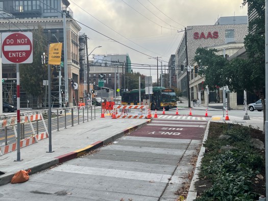
The Union St bus-only lane was added as part of the RapidRide G Line construction. This half-block lane will be used by Route 2, a busy bus route that runs between Madrona and Upper Queen Anne via downtown Seattle. While the rest of the projects part of the G Line construction are complete and in use, Metro busses have not used this bus lane or stop. King County Metro is concerned that the lack of a pedestrian signal across Union St may lead to a bus/pedestrian collision.
A key feature of the bus-only lane is that it acts as a modal filter to reduce the number of cars on Union St between 12th Ave and Broadway. People driving to destinations can still do so via 10th Ave and 11th Ave, and through traffic is significantly reduced. Fewer cars on this segment of Union St improves Route 2’s reliability and makes the street safer for people biking. Union St is a primary route for people biking between the Central District and downtown. Opening this lane to general traffic will slow down Route 2 and make biking on Union St more dangerous.
As previously reported by The Urbanist and the Capitol Hill Seattle Blog, the Seattle Department of Transportation initially decided to remove the bus-only lane after complaints from a few nearby business owners. A change of this magnitude should warrant a traffic study and community outreach, neither of which occurred. Instead, SDOT caved in to a few business owners who are concerned about people driving from the Eastside or Madrona (yes, Route 2 travels between Madrona and this intersection). SDOT removing an already built piece of infrastructure due to a few complains would be a bad precedent to set.
After word got out about the removal of the bus-only lane, SDOT, Councilmembers Joy Hollingsworth and Alexis Mercedes Rinck, and the Mayor’s Office heard concerns about the change. In response, SDOT shared an update on Thursday that stated the bus-only lanes were here to stay (for now). The initial set of changes taking place include:
- Maintain red bus lane markings
- Add a pedestrian signal at 12th Ave and E Union St (across Union St)
- Shift the eastbound bike crossing to 11th Ave
After these adjustments are implemented, Route 2 will start using the Union St bus lane.

While no one likes the Seattle Process, it does often ensure that all feedback is considered so the best option is selected. The initial lack of community outreach for removing the bus-only lane suggests SDOT knows this is unpopular, dangerous, and will worsen traffic. There is no reason to encourage driving in one of most walkable, bikeable, and transit friendly neighborhoods in Washington state. Unfortunately, the bus lane is not out of the woods as SDOT is going to continue “conversations and evaluations with all stakeholders before advancing changes to bus lane uses”.
This whole debacle is another reminder of the challenge faced by advocates trying to improve Seattle’s transportation system. Tom Fucoloro of the Seattle Bike Blog perfectly described the situation in his excellent article yesterday:
“[T]he city is demonstrating a gross double-standard in which community efforts to improve our streets for walking, biking or transit are forced to slog through an endless public process while a change that benefits car drivers at the direct expense of everyone else does not require any public notice at all.”
This is an open thread.
As a bus rider, I’m confused as to why Metro never returned the 2 to westbound Union St.
As a motorist, I understand the support to de-transit this 1/4 block. Thanks to the G-line restructure, traffic back-ups along Madison have become perpetual. Additionally, one can no longer turn right onto 10th or 11th Ave. This leaves an iddy-biddy turn onto Seneca St, which leads you directly into the pedestrian crowded Pike St.
I value pedestrian safety and transit access. But I feel many of SDOT’s plans for bus-only lanes, protected bike lanes and street-narrowing is starting to backfire. For example, the 60 has become much slower through First Hill because of the G-line restructure. The 40-southbound now gets stuck in traffic much earlier on Westlake Ave N because it has been reduced to a single lane. Some of the new protected bike lanes are making it difficult for large trucks to turn, forcing them turn into oncoming traffic or jump the bike barrier.
I feel SDOT is prioritizing philosophy over practicality.
The 40 is generally faster than before, it’s using the bus lane. I’m not sure how you’re saying it’s backed up in Westlake. Or if you’re talking about am peak that was backed up before the change as well.
The 60 I’ll concede could have added bus lanes instead of protected bike lanes.
> Some of the new protected bike lanes are making it difficult for large trucks to turn, forcing them turn into oncoming traffic or jump the bike barrier.
On 15th avenue? I don’t really remember trucks being common there. Secondly it is to deter trucks and cars from entering the protected bike lanes like they would with just painted bike lanes.
In any case with the plastic bollards usually semi trucks don’t really get damaged even if they are forced to run them over.
I would disagree regarding the 40. In my own experience, northbound is no faster along Westlake Ave N because traffic was never an issue north of Valley St. Due to the very few intersections and driveways along Westlake, all traffic moved along quite smoothly – even during PM peak. Still does. In fact, buses had (and still do) a tendency to dangerously speed and overrun stops.
Southbound, the 40 becomes stuck in traffic around Galer St because of the lane reduction. Granted, it always ran into a bottleneck when turning left at Valley. But buses become stuck much earlier now.
> Still does. In fact, buses had (and still do) a tendency to dangerously speed and overrun stops.
Uhh so your complaint is the buses are too fast northbound?
In any case I’ve been stuck on buses going northbound during pm peak.
> Southbound, the 40 becomes stuck in traffic around Galer St because of the lane reduction. Granted, it always ran into a bottleneck when turning left at Valley.
That left turn southbound onto Westlake there took forever because basically only one or two cars cleared the left turn since they were all continuing to Mercer street.
The new left turn from the right lane allows the bus to avoid most of that situation. It might be slightly slower around galer but it’s much better reaching south lake Union and further to downtown.
During really heavy peak periods the southbound direction in Westlake is just backed up from southbound 9th avenue waiting for right and left turns onto Mercer street. It doesn’t really matter if 1 lane or 2 lane on Westlake
Again, the work is not done for the 40. It is a bit premature to consider a failure when key pieces haven’t even been implemented yet.
@WL… no, my complaint is the bus lanes on Westlake were not needed whatsoever. In fact, they’re hurting the 40 southbound. The 40 northbound is no faster, which proves the bus lanes are pointless. The 40 southbound is slower because the bus lanes reduced Westlake to a single lane.
Route 2 did not return to Union St because Metro wanted a pedestrian crossing signal across the bus lane. SDOT just installed the signal yesterday and it should be turned on within the next few weeks. Route 2 will start using the bus lane when that happens.
Traffic in a city is unavoidable. The question is how many roads should be congested. By keeping the traffic on Madison, only car drivers are directly delayed. The G Line can pass the traffic in the bus lane and Route 2 can use Union St. If this bus lane is removed, some of the traffic will move from Madison to Union. This would be better at first, but soon both streets will be bumper to bumper (induced demand). Not only will more drivers be stuck in traffic, Route 2 riders will be delayed as well.
The pedestrian crossing is visible in Google Maps today if you click on Union on the other side of Madison and look backward, and the pedestrian signals are in place. One can’t see if they are operating from that viewpoint,though.
The eastbound overhead ends a block to the west, at 11th Avenue. I guess the eastbound trollies go to off-wire power to make the bowtie? The overhead doesn’t reappear until 14th Avenue. The same appears to be true westbound; the overhead ends at 14th and resumes at 11th. Does anyone know why the overhead doesn’t make the bowties? Aesthetics on the fancy New and Improved Madison Boulevard?
Do the Union buses use the bus lane and get a queue jump that allows them to cross in front of the stopped westbound traffic or do they have to waddle through the cars in a land directly adjacent to a bus lane?
The jump cycle could depend on a signal from the bus.
Michael: amen.
> “I value pedestrian safety and transit access. But”
If you value pedestrian safety and transit access, you have to understand that in the limited street space that a city has, you can’t ever prioritize motor vehicle access. It will erode transit and pedestrian conditions no matter what. All of the issues you describe are issues of motor vehicles slowing down buses. Choosing to blame adjacent transit and bike projects is just obfuscating the root cause.
> “As a motorist, I understand the support to de-transit this 1/4 block.”
As someone who owns a car, I cannot understand the reasoning at all – even from the businesses perspective. The limiting factor for motorists access to any place in Capitol Hill is parking, and probably always will be. It’s not like anyone in their right mind expects to drive to the corner of 11th and Pike, park outside, visit Chophouse Block, and then drive back. Rational people understand that if you drive to Capitol Hill, you’ll be looking for parking within a few block radius of your final destination, and you’ll be willing to walk a fair distance. Having safer walking conditions – something which the bus lane at 12th and Union helps appreciably with – benefits everyone – especially business owners in busy commercial districts.
>> The limiting factor for motorists access to any place in Capitol Hill is parking, and probably always will be.
I think a lot of it is what you are used to. If you grew up in Seattle you have this idea of what downtown is. You know that it sucks to drive there and you rarely do it. For a lot of people, the only place they will take transit is downtown (or maybe to a big event). You tend to think of other areas as being car-friendly. But times change. It is no longer easy to park in places like South Lake Union, the UW, Ballard or Capitol Hill. it is also harder to drive in those areas. Sure, some of the roadways have changed, but mostly it is just a lot more traffic. When I was a kid I remember Denny being a wonderful street. I remember my dad making all the lights (they were timed). Those days are gone. They did nothing to the street. If anything they made it a bit faster for cars. There are just too many of them now. Capitol Hill is a pain when it comes to driving just like driving downtown was when I was taking driver’s ed. But my dad could have said the same thing about downtown (that it used to be easy to drive there) but instead of complaining he just found other ways to get there (mostly biking).
“you can’t ever prioritize motor vehicle access”
This is the type of cookie-cutter thinking that narrows the mindset of transit advocates (full disclosure: I take the bus & train daily and multiple times a day). We must understand that we cannot punish people for using their automobile. There are some neighborhoods where street-narrowing, bikes paths and bus lanes make sense (Dexter Ave, 45th St). And there are some areas where it makes zero sense or make things worse (i.e. Route 40 project, 6th Ave S). The small business owners at 11th & Pike had real concerns that should be heard, respected and given genuine consideration – not broadly dismissed.
We must understand that we cannot punish people for using their automobile.
No one is punishing people for using their automobile. We are simply prioritizing other modes of transportation. There are several reasons for this, but here is a big one: Prioritizing cars doesn’t work. Look at Los Angeles. For decades they prioritized cars. They kept adding lanes to the freeway. They did various things to make driving easier and combat congestion. Yet driving just got worse and worse. Now consider the opposite. Amsterdam prioritized everything else (biking, pedestrians, transit). The result? It is actually much better for driving than in most American cities. To be clear, it isn’t like they ignored the roads. They tend to be in great shape. They know very well how to handle traffic. But by prioritizing other modes, fewer people drive. By having fewer cars they can handle them easier.
It comes down to the fact that other modes of transportation scale better. Bikes and buses take up a lot less space. This in turn means they don’t create as much traffic. Not only that but with transit there is an economy of scale. The more people use buses the more cost effective the transit system is. In contrast, cars don’t scale. Once you reach the limit of the roadway, you are screwed. Yeah, sure, sometimes you can widen the roadway but that isn’t cheap. You end up with the situation like Mercer or Denny. Those are major, car oriented roads and yet they suck for cars.
@Jordan
Why should small business owners be the only people consulted? There was no public process to indicate that this bus lane may be deleted, just some complaints from two real estate offices and the owner of the Chophouse Block. Sure, SDOT should listen to them, but they should also say “no, we just finished a $125M project with federal funding that had a decade long planning process before construction began. That was the time where we were taking public comment and input on how the route and surrounding area would look.”
And I think we should broadly dismiss complaints from business owners that people can no longer drive to the front door of their business and park directly outside on the grounds of that being a stupid complaint. In a dense urban environment, if the only reason people visit your business is that parking is easy, you’re not going to be in business for long.
As a bus rider, I’m confused as to why Metro never returned the 2 to westbound Union St.
It wasn’t Metro, it was SDOT. SDOT has a bunch of projects and somehow this got delayed. Hard to say why.
traffic back-ups along Madison have become perpetual
Seattle is a big city now. Traffic is inevitable. There are really only two things you can do:
1) Provide a transit alternative.
2) Toll various roads.
RapidRide G provides an excellent transit alternative. A toll on Madison would reduce traffic there. So would a toll on Denny. But I don’t think it would be particularly popular. It is also cumbersome to implement (although adding bus lanes seems to be taking a while).
While tolling can reduce the number of cars on the road, so does reducing lanes. It is essentially the same thing as induced demand (it is just that you are subtracting instead of adding). Once a city reaches a certain size, traffic is a zero sum game. For example if there is an accident on northbound I-5 around Federal Way and I’m driving back from Snoqualmie Pass it means that my drive home will be better than usual. It sucks for them but it is good for me. This can happen on a longer term basis as well. Madison is worse for general purpose traffic but it is probably better on 23rd, north of Madison (since there are fewer cars turning onto that street). Sure enough, the on-time performance of the 48 is the best it has ever been (or at least with recent records).
Thus there are winners and loser. Madison is a big loser now for general purpose traffic. The 60 shouldn’t run on it. It would probably save a lot time if it just kept going on Broadway (although Broadway is no picnic either). If they insist on keeping the detour then it should not have any bus stops on Madison. The stops should be moved to 9th and Broadway. That way the bus can use the same center lanes as the G (before shifting into the left turn lane).
For Westlake Ave southbound, two-way-left-turn lane is the reason for lane reduction. If it was not for the motorists, they would have put southbound bus lane from the very beginning and 40 wouldn’t be stuck.
Clearly they aren’t done with the 40. I don’t think Westlake is done either. I’m not 100% sure, but from what I can tell the southbound lanes will work like this when the project is complete:
At 36th (in Fremont) there will be a southbound bus lane approaching the bridge. Then there is two lanes of general traffic crossing the bridge. This continues until the turn onto Westlake. At that point, the curbside lane is for buses. Cars are supposed to merge left. So there will be a tiny section of bus lanes next to a general purpose. Then they merge into one lane while they add a center-turn lane. It will be basically one lane southbound (and a middle turn lane) until here (between Newton and Garfield). Then there will be a bus lane along with general purpose lane all the way to 9th. Then it is BAT lanes pretty much all the way to Lenora. The main reason things will be weird southbound in the northern part of Westlake is because of the turn lanes. But it still looks pretty good.
I think the main weakness is over the bridge. They should just take a lane. There will be BAT lanes approaching it from Westlake but not 34th. This may be what you are getting at. Make that one lane and you can add BAT lanes the whole way (from the 36th in Fremont to the shared section). The only impact would be drivers from the east on 34th but I could live with that. I suppose one issue is that the 31, 32 and 62 all use 35th. There are no bus lanes there. If 34th is worse than more drivers shift to 35th which would hurt those buses. In the long run though, they should add bus lanes on 35th (at the very least westbound). Then you can change 34th so that only one lane turns. At that point you can add a southbound BAT lane across the bridge and over to Westlake.
Sources: Fremont, Westlake
I don’t really understand this. There are right turns available on Pike, Pine, and Seneca. Yes there are a lot of pedestrians but that’s true for this entire area. If you are headed to First Hill, any right turn is available after Broadway
Yes, SDOT and Metro should reconsider the Route 60 pathway. Its current speed should be compared with that from fall 2018 before the G Line construction; I expect it is slower as it uses the congested general purpose lanes. Route 60 could be shifted to the Route 9 pathway that is more direct. If serving the front door of Harborview is crucial, it could use East Jefferson Street and 9th Avenue. If covering 9th Avenue north of East Jefferson Street, one of the ETB routes 3 or 4 could be shifted to 9th Avenue and Spring-Seneca streets; note congestion on James Street. (RossB has made a suggestion; how long would that take to implement?).
There may have been several issues with Route 2. The overhead has not been restored more than a year after fall 2024. The safety issue of unsignalized pedestrian and bike movements across the westbound transit movement. It appears that the westbound general purpose lane on East Madison Street is often full of cars; would the Route 2 coaches going north-to-west have lane space to turn into? Does SDOT have the signals at 12th and 13th timed correctly for the Route 2 movement?
In designing the G Line, I suspect SDOT did not consider Route 2 well.
Per a RossB comment below, the Route 40 project is still under construction. But the part I dislike has already been implemented. The northbound stop between North 34th and 35th Street was removed; the stop of routes 31, 32, and 62 was shifted around the corner to North 35th Street; the stop for Route 40 was shifted west to near the statue. This destroys the common stop transfers. Riders transferring to/from Route 40 will have to cross two legs of the busy intersection and travel (walk, roll) about 520 feet; that is a wide seam. Before the change, riders in downtown could take either routes 40 or 62 to reach routes 31 and 32; now, they may have a preference for Route 62 and more waiting.
“In designing the G Line, I suspect SDOT did not consider Route 2 well.”
The G was going to be moved to a Pine-12th-Union route. For some reason Metro changed its mind in the last year and didn’t do it.
I guess more broadly maybe route 60 should be rerouted to be north/south since it can’t use the center bus lanes on Madison?
It can use the lanes, it just can’t use the bus stops. So as I wrote up above it should either stay on Broadway or not stop on Madison. The latter would mean adding bus stops on 9th and Broadway.
It could perhaps jog with the 2 on Seneca instead of Madison
I don’t really see a path to moving off of 9th without a replacement bus on Boren or 9th. I’m pretty sure the segment through First Hill is the busiest segment of the 60.
It could perhaps jog with the 2 on Seneca instead of Madison
Good point. That could work.
I don’t really see a path to moving off of 9th without a replacement bus on Boren or 9th.
I do. You’ve got very good coverage in there even if the 60 went straight on Broadway. It isn’t a normal grid so it isn’t easy to explain, but you’ve got buses heading towards the water fairly well spaced. The 3/4 actually doglegs to increase coverage. Service on Broadway complements it. There are small gaps but that is true everywhere. It is like people arguing for buses on 1st and 5th, except it is a weaker argument. Those streets are parallel to buses on 3rd and we have an excess number of buses on 3rd. Shifting a few wouldn’t hurt 3rd in the least. It is also easy to imagine a long trip taken on one of those streets, making the out and back especially tedious. But in this case the bus only stays on the side street for a short section. A Boren bus (or something similar) would be different.
If the 3/4 shifts to Yesler then it would serve the most popular stop in the area (next to Harborview). The difference would be that the “detour” would be faster than the current 3/4. Specifically it would be faster when there is traffic and about the same when there isn’t. Even without that you’ve got good coverage in the area.
As far as ridership goes, here are some numbers:
Broadway E & E Republican St       209	206	3

Broadway E & E Thomas St        106	98	8

Broadway & E Denny Way                   316	294	22

Broadway & E Pine St           	        83 	65	18

Broadway & E Pike St           	        296	247	49

Broadway & E Union St          	        101	72	29

Madison St & Boylston Ave      	190	72	118

Madison St & Boren Ave         	        184	97	87

9th Ave & Marion St            	        169	96	73

9th Ave & Cherry St            	        57 	19	38

9th Ave & Jefferson St         	        357	164	193

9th Ave & Alder St             	        115	77	38

E Yesler Way & Broadway        	        179	70	109

12th Ave S & S Jackson St      	173	34	139

12th Ave S & S Weller St       	268	162	106

...

Beacon Ave S & S Lander St     	565	305	260
The first number is total, the second number is southbound boarding, the third is southbound alighting. I don’t know why there is a Broadway & Pike along with a Broadway & Pine. Anyway, the only really big ridership stop is 9th & Jefferson (Harborview). This is actually fairly close to Broadway. The other stops aren’t that impressive. None of the stops are as big as the one next to Beacon Hill Station (which is why I included it). In any event there are a significant number of riders on the detour — but there are actually more riders to the north of it (on that small section of Broadway).
But that doesn’t tell the whole story. Detours take time. They delay through riders and they mean buses run less frequently. In this case it eliminates the possibility of a high-frequency Broadway corridor. Imagine if the 4 just turned on Broadway and went up to Union to get more riders and then looped back (on 12th) before heading east again (towards Garfield High). It might pick more riders there but then you wouldn’t have the outstanding 3/4 combined headways in Cherry Hill and Garfield. That is basically the situation on Broadway. The streetcar has decent frequency. The 60 has decent frequency. But neither has outstanding frequency. The only way to get outstanding frequency on Broadway is to combine routes and the easiest way to do that is with the 60 and streetcar.
@Ross Bleakney
To clarify what I mean is that I don’t think it’s politically feasible without a larger restructure in the area.
I think it’d be best to send the 106 up 9th or Boren and send the 60 straight up Broadway. The 106 heading down Jackson seems unnecessarily duplicative to me.
To clarify what I mean is that I don’t think it’s politically feasible without a larger restructure in the area.
You are probably right. It is hard to make small changes because several things depend on other things. But I could also see this as part of moving the 3/4 to Yesler. That would be a relatively small set of changes with some trade-offs. Riders who are used to the stop at the front door of the Harborview with the 60 would get it with the 3/4. Riders in the Yesler Terrace would be much better off. They would have a frequent service heading downtown or up Broadway. But other people would have to walk farther (or take a connecting bus) to get up to Beacon Hill (or get downtown). There would definitely be winners and losers but overall it would be significantly faster.
After that I would want to connect the 60 with the 49 but would likely require swapping tails with the 36 and that does seem like a bigger deal. In general it is politically easier to make a bunch of changes because people see the big increase in frequency (along with stuff they miss). It is hard to do that with little changes.
@Ross… to answer your question regarding Pine / Pike along Broadway. There is a stop at Broadway & Pine, north of pine. Cars park in front of it all the time. The next stop is Broadway & Pike, north of Pike. I really wish Metro got rid of the Pine stop because it’s so close to the stops before and after. Plus, the 49 serves it too and makes the very next stop a half block around the corner.
Thanks Jordan. Now I see it. Google shows both bus stops but I had to zoom in more. They also call the one south of Pine “Pike-Pine” which is confusing and made me think that the only one. Anyway, I agree. They should get rid of the stop on Pine.
Ross, I agree that “detours take time”, but in this case the detour is so close to the end of the route that it probably doesn’t make much difference. Most people coming from west Beacon Hill are probably going to First Hill, not the Broadway District. If they are going to Broadway, they really ought to consider taking the elevator down to Link and up to Broadway, beating the bus even if it stayed on Broadway all the way. There are just. too. many. stoplights.
Jes’ sayin’
Most people coming from west Beacon Hill are probably going to First Hill, not the Broadway District.
Look at those numbers again. More people are riding the bus past the detour than the detour itself. About twice as many.
Ross, I agree that “detours take time”, but in this case the detour is so close to the end of the route that it probably doesn’t make much difference.
Except it does. You pretty much eliminate the possibility of combining headways on the corridor. So not only does this delay the majority of riders but it also screws up riders who just want to get from one end of Broadway to the other. The delay also takes longer which means the buses run less often. Sure, Broadway is slow. But making a bunch of extra turns and going on other busy streets is slower. Speaking of which, it is much easier to make one corridor better for buses than two. Broadway is already a transit priority. It is hard to imagine them improving the detour before they improve Broadway.
Yes, AND let’s look at the details. By the time the bus leaves Union, the Ons minus the Offs gives 853 on board. At Alder there are 831 on board, and there has been a total of 547 alightings. Essentially 2/3 of the riders have gotten off the bus on First Hill. So, those riders you point out are not actually riding the bus all the way to Beacon Hill. This is two bus services joined end-to-end: west Beacon Hill to First Hill and Broadway District to First Hill.
https://www.facebook.com/photo/?fbid=657663387395529&set=a.230912470070625
That there are some riders who pass through the common destination is just as important as the 5 riders who continue on to Starbucks. That is, they are lucky that they have a non-transfer ride. When there’s a baseball game, they suffer, but overall it’s better than transferring.
By the time the bus leaves Union, the Ons minus the Offs gives 853 on board.
That isn’t quite accurate, and that is my fault. You aren’t getting the complete numbers because I only copied a subset. Another 56 riders board at 10th & Mercer. I have copied the spreadsheet to the web (something I should have done initially): Here it is. With that in mind, it changes the numbers a little bit:
Southbound boardings and alightings until (and including) Union: 1038, 129
Southbound boardings and alightings until (and including) Alder: 525, 547
So I see your point. Not that many riders are going from the north end of Capitol Hill go past the detour.
But so what? The argument I was making (which is still valid) is that there are a lot of riders from the north end of Capitol Hill. Many want to go down Broadway. This includes riders who end up on the detour. Broadway & Boylston might as well be on Broadway and it got 118 alightings. 9th & Jefferson got a lot of alightings and it is not that far from Broadway. If I’m taking a trip like this than I take whatever comes first — the streetcar or the 60. But I can’t do the reverse. So instead of having an effective frequency of 6 minutes (on a weekday) I have to live with 12 minutes.
Note that the bus stops on the detour that are farthest from Broadway had relatively low alightings. The three bus stops that are farthest away (Madison & Boren, 9th & Marion, 9th & Cherry) have less than 200 alightings combined. In my opinion, these are the only stops that add real coverage. Of course this is a judgement call but if a stop is within a five minute walk to a bus stop on Broadway I would not consider it additional coverage.
Consider the numbers again, with that in mind. I’ll also include numbers until Jackson. Like above, this is southbound boardings and alightings (all numbers are inclusive). This is what I get:
10th & Mercer to Madison & Boylston: 1110, 247
Madison & Boren to 9th & Cherry: 212, 198
9th & Jefferson to 12th & Jackson: 345, 479
Relatively few riders benefit significantly from the detour. More endure the detour, but not a lot either. The vast majority of riders never experience it all. But that doesn’t change the argument (if anything it strengthens it). The riders who never experience the detour just want the 60 to be more reliable and run more frequently. A lot of people would benefit from the combined headways down Broadway. The detour just isn’t worth it.
It is worth noting that if the streetcar was a normal streetcar and was running really frequently (say, every five minutes) then I wouldn’t be proposing this. I would be OK with the detour of the 60 and would probably suggest the bus work its way up to Boren and over to South Lake Union. If someone is trying to keep going north they could just hop on the streetcar.
But the streetcar doesn’t run that often. It only runs every 12 minutes at best. I realize that sounds great (if you are used to taking a bus that runs every half hour) but for short trips it is not very good. In some cases you spend more time waiting than you do riding. It is also not good if riders have to transfer. Creating very-high frequency routes (or combination of routes) makes a huge difference. We now have a high-frequency bus route on Madison. We should provide the same level of service for Broadway. The easiest and cheapest way to do that is to alter the 60.
The 60 doesn’t go to the north end of Capitol Hill. Its terminus is at Harrison/Mercer Streets. That’s in the middle of Capitol Hill. It doesn’t even reach Aloha Street (Volunteer Park).
The right turn to East Union Street from Broadway is too tight for a standard bus. It was tested.
I didn’t know the 60 was slower since I ride it a couple times a year. What exactly is making it slower?
The cycletrack on Broadway is SDOT prioritizing bikes over transit (streetcar, buses). We need transit lanes on Broadway, and the cycletrack can move to 12th.
What exactly is making it slower?
I assume it is additional traffic on Madison.
We need transit lanes on Broadway, and the cycletrack can move to 12th.
I agree. That would be a lot better.
Post G-Line restructure, the 60 is getting stuck in traffic with general traffic along Madison… now that Madison is a single lane in each direction. This is often the case during the afternoons.
Yes, that is what I suggested to the McGinn SDOT at the time. There was significant civil work. It would be hard and costly for SDOT to go backward. SDOT has added significant bike infrastructure to 12th Avenue. I like it better; it is not a two-way cycle track.
“A key feature of the bus-only lane is that it acts as a modal filter to reduce the number of cars on Union St between 12th Ave and Broadway. ”
SDOT has a terrible case of myopia here.
Between Broadway and 12th, a driver has several choices — Pike, Pine, Union or Madison. South of Madison the SU campus is closed to traffic. North of Pike is Cal Anderson Park and narrow residential streets.
SDOT can’t seem to pick just one street to accommodate through traffic. It seems to me that if they did, things would work better and be safer for the three other streets.
Blocking Union Street just adds traffic onto Pike Street. Yet Pike Street should be the one more pedestrian friendly rather than Union Street.
Keep in mind too that there’s a critical fire station at 13th and Pine. Fire engines need to get through this area, and the new, taller 5 over 1 residential buildings increase the need for a rapid response. All the new street treatments in the area deter rapid fire response.
There’s also a need to realize that there are hospital ERs in the area too. Ambulances need to be able to get through.
I get that there are storefront businesses on both streets now. Of course they want traffic flow to maximize their presence.
SDOT has to determine what’s the right thing to do. Frankly, SDOT needs to pick one of these streets and make it the traffic through street. But SDOT also needs to repair the damage to east-west through traffic that they created in this corridor by putting in street treatments individually. It’s an area that not only is a vibrant district, it’s also one that has through streets that serves thousands of other people as well as houses thousands of residents that pay for and deserve good fire protection — and has critical emergency rooms in nearby hospitals. .
Are there problems with travelling E/W across Cap Hill? I’ve never had major issues driving. There are dozens of side routes if you are willing to dogleg to your destination. I rarely get delayed on the 8 there either. SLU is much worse in that regard.
Emergency vehicles can use bus lanes. I’ve seen plenty using the Madison St bus lanes.
SDOT can’t seem to pick just one street to accommodate through traffic. It seems to me that if they did, things would work better and be safer for the three other streets.
I agree with the approach you are suggesting. Basically we create car streets and transit streets. This allows the city to slowly improve the transit streets and transition to a more transit-oriented city. Yes, I have read all the literature. I know very well about “traffic evaporation”. But I also know that some of the cars will simply find a different route. Giving them one is good policy (in the short term). Eventually you can ignore car-streets but we aren’t there yet.
For example, consider Denny. One of the reasons I am so adamant about adding bus lanes there is that there is a parallel car street: Mercer. Cars will shift there. No problem. No buses run there (at least west of Queen Anne Avenue). I don’t see traffic backing up that far. Get bus lanes on Denny (and a lot of other streets) and eventually, someday add bus service for Mercer. That is a solid, iterative approach that I think will work.
This brings me back to the particulars you mentioned. It is hard to write about corridors because the streets curve. But I would say the Denny/Olive/John/Thomas corridor (the 8) is a major one. So is Madison. In between there you have Pike/Pine. South of there you have Jefferson/James (the 3/4). That doesn’t leave a lot of car-streets. Seneca/Union could be one but you have the 2. That is one reason why I think the 2 should dogleg over to Pine. Then we can add more right-of-way on Pike and Pine. This would push traffic to Seneca and Union — but that would be OK, since no buses would be there. At least not west of Broadway. But the dogleg is not trivial. It would be fairly easy westbound. Just turn right on 13th, replace some parking with a bus stop (between Union and Madison) and add BAT lanes as necessary on 13th. But going the other way it would be challenging. Maybe you could go the other direction on 12th or 13th but I see potential issues with that. But it does seem quite easy if you go on 11th and leverage the bus lane. You just have buses going the other way (south on 11th, east on Union). Thus even if the bus doglegs to Pike it may still end up using that little bus-lane (just in the opposite direction).
But that is all long term. For now you still have the 2 on what could be considered a “car street”. This little bit of right-of-way is essential for the biggest transit street east of 3rd Avenue downtown: Madison. With the 2 routed on Madison and turning on Union it needs space. If it doesn’t have space — if traffic is backed up and it can’t make the turn — then not only is it bad for the 2, it is bad for the G. So yes, in the long run we want to move the 2 over to Pike/Pine. But for now we at least need to improve this particular section for it. At some point though, we should definitely make Pike/Pine faster (since it is a major transit street).
As far as emergency vehicles, I get your point. We should add a lot more BAT and bus lanes. These are how emergency vehicles can get through the traffic. People don’t mention that enough (bus lanes are emergency vehicle lanes).
OK, I made a mistake. I actually made a mistake yesterday as well (on Bluesky) but no one noticed. The 2 can’t delay the G there. I forget to double check the roadway. The G is running in the center at that point and the 2 is running curbside. So this is more of just a simple improvement for the 2 on its current routing.
Why can’t the 2 use the bus lane with a triggered queue jump signal so that it turns in front of the cars in the general purpose lane? The station is mid-block, so if the 2 is waiting for the light at 12th a G approaching from the east could still stop at the station. By the time it completed its station work, the queue jump would have cleared the 2 out of its way.
It would hardly affect the traffic in the GP lane because the headway never is lower than eleven minutes.
No, it can’t use the station, and it would have to drive through it slowly for safety, of course.
@Tom — My guess is it could, but I don’t think it would get you that much. My understanding is that a westbound bus (traveling on Union) will turn right on 13th and then make a hairpin left on Madison. That is probably the tricky part. I’m guessing you have to basically be in that curbside lane for at least part of that turn. If it is backed up all the way to the intersection then you can’t use the center bus lanes. You have to wait for traffic to move. Once it does then you can follow the vehicles to the intersection and get back on Union.
I still think the best option is to dogleg to Pine using 13th. I would make Pine one-way northbound from Madison to Pike (just as it is from Union to Madison). That would allow you to add a bus lane. You might need to do that all the way to Pine (where the bus would turn left). You would come back on a different street.
“There’s also a need to realize that there are hospital ERs in the area too. Ambulances need to be able to get through”
Ambulances, when responding to an emergency, can just use the bus lane. They can even use a one way bus lane to drive the wrong way. In the Netherlands, ambulances even bypass traffic, when necessary, using protected bike lanes.
If you want to improve ambulance response times, what you don’t want is every inch of street filled with gridlocked cars.
Only Madison Street has exclusive bus lanes that ambulances can use in this area. The other area streets don’t. There is no transit lane on 13th (or 12th or 14th) or Pine (or Pike) where emergency response teams are based.
While drivers pull over for ambulances and fire trucks, things like curb extensions and lane narrowing make it harder for drivers to get out of the way. So does channelizing street lanes with physical median barriers and protected bicycle lanes.
It’s not admittedly a primary concern. Emergency access however is hampered when almost all of the streets are turned into streets intended to be meant for pedestrians. It works great when a key street or block is the focus, but when a huge area is treated that way emergency access and response time should become a concern.
Many college campuses have huge areas that are pedestrian only, and it’s pretty easy for emergency vehicles to access the various buildings because the sidewalks are designed to serve as service roads. Construction, maintenance and sometimes certain delivery vehicles use them too.
It’s not a concern so long as it is planned and implemented.
Only Madison Street has exclusive bus lanes that ambulances can use in this area. The other area streets don’t.
Yeah, I think we are all in agreement. We want a lot more bus lanes. Not only for the buses but for emergency vehicles. Sure, this is only one small bus lane but I could still see it being important. If someone has a heart attack on 11th & Union the best option for the fire truck to get there may very well be south on 13th, right on Madison (with the bus lanes) and right on Union (with the bus lane). Traffic could be a standstill on other streets and the first responders could still get there. So yeah, more bus lanes.
@ ZHlenn:
“Many college campuses have huge areas that are pedestrian only, and it’s pretty easy for emergency vehicles to access the various buildings because the sidewalks are designed to serve as service roads.”
Seattle U has a guard station on Marion west of 12th. They also have an unmanned gate on Columbia east of Broadway. So an emergency vehicle could travel through the campus.
However I don’t think Seattle U would be too supportive of emergency vehicles cutting through campus to get to ERs at Swedish or Harborview. Of course, the Madison bus lanes are available if needed.
The concern that I’m mentioning is the district between Madison and John and between I-5 and 12th Ave. Unlikely a college campus with guard stations, this area has no such system in place.
> While drivers pull over for ambulances and fire trucks, things like curb extensions and lane narrowing make it harder for drivers to get out of the way. So does channelizing street lanes with physical median barriers and protected bicycle lanes.
This is kinda weird thing to focus on so much. One of the largest needs for ambulances is from car collisions themselves.
Plus it’s not as if when there’s left over road space we don’t just use it for parking or say narrowing the lanes to have more car space. It seems you are just solely focusing on it because it’s a bike lane.
Would you say the same if they added parking?
This quarter block of transit only street probably wouldn’t do much for 2 but sure piss off driver a lot.
In the end it really is just a gesture than actual usefulness.
Your statement is contradictory. If lots of drivers would use that turn then it would delay the 2 (a lot). Either there aren’t that many cars going that way (in which case, what’s the harm) or there are a lot (and they would cause significant delay for the 2).
I don’t remember the details, but recall that studies have been done showing that business owners, as a group, tend to drastically overestimate the importance of customers who arrive by car on sales, and act as though anything that makes driving in the neighborhood slightly less convenient will destroy the business.
In reality, given the neighborhood, the very businesses complaining probably see lots of customers who travel there on foot, bike, or bus. Why do those customers not count, and only people who arrive in a car count?
Perhaps the non-drivers don’t count because the overestimate-car-importance bias of business owners feeds directly into the reality that most of our elected “representatives” wouldn’t deign to set foot on a bus. My armchair reasoning is that these (wealthy) business owners are also in the same boat and drive to most of their destinations, including to their businesses. Who else is really driving in from Madrona and Leschi these days? Not most of their customers, as you point out, and certainly not most of the regular employees.
The people whom the city seems to serve at the drop of a hat are also the ones least likely to ever use transit. I guess that’s why this happening during the week without driving is so ironic; they’re the ones who the week is made for.
Two different observations:
A big share of restaurant business today is takeout delivery. Restaurants will want nearby short-term parking so they can serve that takeout market. It’s not solely about people driving to dine in their restaurant — and takeout is most likely a bigger share of their sales in many cases.
In the specific case of the Pike-Pine corridor, the busiest times of pedestrian activity are probably on weekend evenings. That’s when the clubs also make their money. That’s at a time when many transit routes are not running frequently. With RapidRide G it’s better than it used to be. The area doesn’t have direct transit routes that go further than a few miles except for Link in the evenings though. That lack of long-distance direct transit service often results in lots of Uber and Lyft use, which is why I can see that nightlife businesses have heightened concerns about traffic circulation.
A big share of restaurant business today is takeout delivery
Yes, and in an urban environment like Capitol Hill, most of that is pedestrians. Surely you’ve experienced this in the U-District. Patron after patron picks up an order while you are eating. Where do they all park? They don’t. They live in the neighborhood (or go to school there). I’m not saying there aren’t people who drive there, but you certainly shouldn’t freak about automobile access issues. They will get the food one way or another (many use bikes now).
Now sure, some place like Judy Fu’s on Maple Leaf has to deal with cars. But that is because the area surrounding it is a lot more suburban.
This is something to keep in mind: https://ggwash.org/view/96602/survey-most-shopkeepers-shoppers-overestimate-car-use
“Yes, and in an urban environment like Capitol Hill, most of that is pedestrians.”
The several people I know who live car-free on Capitol Hill order food for door delivery. They mainly order food based on the menu and not the proximity. They will order food from several blocks away if not a few miles, and foot delivery is not practical for that.
It depends on the type of business. Something like a high-end camera store has a huge area from which its customers come, and probably most come by car because they don’t know buses that might be an option.
But a salon or hardware store which have competitors all over the place has a much smaller drawspace. More people walk or take transit to them, depending on what is to be bought.
> While drivers pull over for ambulances and fire trucks, things like curb extensions and lane narrowing make it harder for drivers to get out of the way. So does channelizing street lanes with physical median barriers and protected bicycle lanes.
This is kinda weird thing to focus on so much. One of the largest needs for ambulances is from car collisions themselves.
Plus it’s not as if when there’s left over road space we don’t just use it for parking or say narrowing the lanes to have more car space. It seems you are just solely focusing on it because it’s a bike lane.
Would you say the same if they added parking?
It’s a valid design consideration.
Ambulances are wider than cars and most box trucks in case you haven’t noticed. Fire trucks are not only wider but they also are long and have to maneuver around corners (and sudden grade changes). I would say that fire truck paths are the bigger safety issue.
And I’m not singularly calling out PBLs. I’m calling out an emerging combination of both “… physical median barriers and protected bicycle lanes” which are starting to appear on Seattle streets in some places. Either/or is likely fine. And at least many times SDOT has often installed plastic delineators that can be driven over — although in the past 2 years SDOT has instead introduced lots more taller concrete barriers that can’t be easily driven over. These are very recent design changes that SDOT has now embraced and they can restrict fire truck access if done cavalierly.
Every time the street geometry changes, it should be done carefully. A naive advocate often doesn’t realize that existing street geometries are that way for a reason and it often includes a fire truck access safety consideration.
There have been many horrific urban fires in US history — including in Seattle. One of the worst happened because of the 1906 San Francisco earthquake. We plan for earthquake disasters with things like more stringent building codes. Why have codes for rare events like this — but then propose that assuring fire truck access is unimportant? I’d hate for multiple blocks of Capitol Hill’s dense neighborhoods go up in flames just because a fire truck can’t get there.
I mean it’s patently absurd why not say on say broadway avenue its the parking spots that are blocking the ambulances? We could remove the parking spots and as bus lane the ambulance could use it. Even the same on pike street
Instead you’re just focusing solely on the bikes.
I mean any street with 5 lanes if it had 2 lanes as parking I doubt you’d talk about the neighborhood being burned down. But then we have 1 lane split into biking on each side and now your citing Capitol Hill will be burned down?
Let’s say pike street had 4 lanes and then they added in parking on both sides of the street. One would be rightly mocked if they said Capitol hilll would burn to a crisp with the parking. It just sounds reasonable to you since it’s bike lanes or bus lanes.
Why are we talking about ambulances when the fire department and city aren’t? The slowdowns people on buses are experiencing is definite and significant. Ambulance slowdowns are theoretical and haven’t been proven. Ambulances can switch to any less-congested street around bottlenecks. Buses can’t without a months-long process and public hearings and a county council vote to change the route alignment.
“Why are we talking about ambulances when the fire department and city aren’t?”
Because people want to be able to cut through neighborhoods too fast in cars, but they want to sound sympathetic, so they point to ambulances.