Mayor Wilson’s new proposal to install bus lanes on Denny Way is exciting and long overdue. While most discussion regarding Denny bus lanes pertains to Route 8 specifically, the potential benefit is much greater. Adding bus lanes on Denny Way would provide an opportunity to make transformative improvements to Seattle’s transit system, both for crosstown connections and South Lake Union (SLU) commuters.
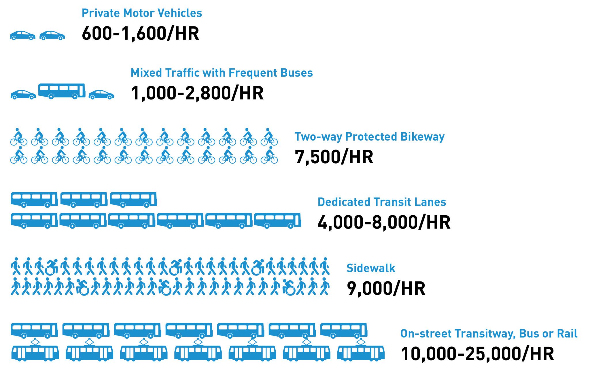
SDOT’s previous traffic studies pertaining to Denny assumed zero people (yes, zero people) would switch from driving to transit if Route 8 became more reliable. Naturally, it concluded that bus lanes on Denny would increase congestion, but it was based on a flawed assumption. Route 8 already carries about as many people as 2 of Denny’s 4 lanes despite being notoriously slow and unreliable, and Commute Seattle surveys show that travel time and reliability are among the most important factors Seattleites consider when deciding their travel mode. That being said, SDOT’s general concern regarding bus lanes leading to traffic diversion is legitimate. Bus lanes increase the capacity of a roadway (see figure below), but only if people can use them. Many drivers on Denny are going places not served by Route 8. The solution to this problem isn’t to avoid bus lanes on Denny. It’s to run more buses down Denny from more parts of the city. Doing so will improve crosstown connectivity, allow more of the city to benefit from Denny bus lanes, and get more people from cars to transit along the corridor. One way to do this would be to reroute Routes 9, 11, and 60 to Denny, which would help accomplish this goal without losing transit connectivity elsewhere in the city.

Route 11 – Shift from Pike / Pine to Denny Way

From East to West, Route 11 currently runs from Madison Park, down Thomas & John, to the Capitol Hill Link Station. From there, it continues on Olive to the Pike/Pine corridor. Already today, passengers are better off transferring to Link at Capitol Hill to get downtown than they are staying on the bus. If buses west of the Capitol Hill Link station are rerouted onto Denny, passengers could continue to transfer to Link for faster Downtown service, or stay on for service to SLU or Seattle Center. Service on Pike / Pine would remain thanks to Routes 3, 10, 12, & 49.
Routes 9 & 60 – Reroute onto Boren & Denny


Before Link was extended to Capitol Hill, routes 9 and 60 connected SE Seattle to employment centers in Capitol Hill. Today, that connection is better served by Link. Just like with Route 11, passengers seeking to go all the way to Capitol Hill are better off transferring to Link at Beacon Hill or Mt Baker, and passengers going between First hill and Capitol Hill have Streetcar service. That being said, these routes continue to connect communities between link stations (like First Hill Hospitals & Yesler Terrace). Rerouting 9 & 60 down Boren and Denny would maintain SE Seattle – Capitol Hill connections, maintain First Hill – Capitol Hill connections, maintain SE Seattle – First Hill Connections, and create new crosstown connections from First Hill to SLU & Seattle Center.
As shown below, rerouting buses 9, 11, and 60 as noted above will not result in increased travel times along their previous corridors for most riders, thanks to existing Link and Streetcar service.
| Origin to Destination | Travel Time using Existing Routes | Travel Time with Proposed Re-Routes |
| Capitol Hill to 2nd & Pike | 17 minutes (Route 11) | 9 minutes (Link) |
| Capitol Hill to Beacon Hill | 30 minutes (Route 60) | 18 minutes (Link) |
| Capitol Hill to Mount Baker | 26 minutes (Route 9) | 20 minutes (Link) |
| Yesler & Broadway (Yesler Terrace) to Capitol Hill | 13 minutes (Route 60) | 12 minutes (First Hill Streetcar) |
| Yesler & Broadway (Yesler Terrace) to Denny & Westlake (SLU) | 20 – 30 minutes (Routes 14 & SLU Streetcar) | 15 – 20 minutes (Routes 9 & 60) |
| 9th & Jefferson (First Hill) to Capitol Hill | 12 minutes (Route 60) | 14 minutes (First Hill Streetcar) |
| 9th & Jefferson (First Hill) to Denny & Westlake (SLU) | 25 minutes – 30 Minutes (Route 3 to Route 40) | 10 – 15 minutes (Routes 9 & 60) |
The following table shows service frequencies along multiple corridors if this Route restructure took place. Note that it’s assumed each Route could maintain the same frequency after the restructure. While distances between existing and proposed Routes are largely comparable, additional analysis would be required to confirm this, accounting for speed & reliability improvements from Denny bus lanes.
| Corridor | Service Frequency (Now) | Service Frequency (Proposed) |
| Denny Way | Peak: Every 10 mins. Off-Peak: Every 15 mins. (Route 8) | Peak: Every 4 mins. Off-Peak: Every 5-6 mins. (Routes 8, 9, 11, & 60) |
| Capitol Hill Station to SLU/Seattle Center | Peak: Every 10 mins. Off-Peak: Every 15 mins. (Route 8) | Peak: Every 7-8 mins. Off-Peak: Every 10 mins. (Routes 8 & 11) |
| Boren Ave | No Service | Peak: Every 8-9 mins. Off-Peak: Every 12 mins. (Routes 9 & 60) |
| Broadway | Peak: Every 3-4 mins. Off-Peak: Every 4-5 mins. (On Routes 9, 43, 49, 60, and Seattle Streetcar)* | Peak: Every 6-7 mins. Off-Peak: Every 7-8 mins. (On Routes 43, 49, and Seattle Streetcar)* |
| Pike-Pine | All day: Every 4-5 minutes (Routes 3**, 10, 11, 12, & 49) | All day: Every 5-6 Minutes (Routes 3**, 10, 12, & 49) |
* No every route serves all of Broadway
** Route 3 only serves part of the Pike-Pine corridor
The details of a proposed restructure associated with Denny bus lanes could certainly be modified or adjusted, this is just one proposal. However, there is an opportunity to leverage new Denny bus lanes to make significant improvements to transit service – both crosstown and to South Lake Union. Transit advocates should leverage this opportunity to demonstrate how transformative Denny bus lanes could be for Seattle.
I like these ideas. I will say I don’t think the 60 reroute makes sense. Bus networks should be grid like, if the 8 is fast and reliable, it would be totally fine to take the 60 to where it crosses the 8 and transfer. Plenty of people ride the 60 all the way from capitol hill station through to points south.
For the same reason though I think making 11 a east west crosser is a great idea.
The most strategic east-west corridor in Capitol Hill is Pine-Madison. It connects the most destinations and is in the middle between others: Pike Place Market, 3rd Ave bus transfers, retail core, southwest Capitol Hill cultural area/dense apartment area, Broadway, 15th, Trader Joe’s, Madison Valley, and Madison Park. The Broadway shopping concentration is a few blocks north; the medical district and First Hill highrises a few blocks south.
The 11 used to serve this corridor. Now the 12 does, at least to 19th. I’d like to see the 11 move back to it and become a full-time frequent route (15 minutes minimum). Metro has persistently overlooked this, and the 11 has always been less frequent than other Pike-Pine routes.
The current 11 goes on Pine-Olive-John-Thomas-Madison, partly following the current 8 and former all-day 43. The advantage of the Pine-Olive-John alignment is it serves another popular corridor in Capitol Hill and goes right to the Capitol Hill station entrance. The disadvantage is more passengers prefer Pine Street.
When the 10 was rerouted from Pine to John, many 10 riders switched to the 11 to remain near 15th & Pine. The expected rise of people taking the 10 to Capitol Hill station rather than staying on to downtown didn’t happen. In the second restructure last August, the 10 was moved back to Pine, and the 11 was moved to John to replace it.
I still feel a Pine-Madison route is very important. The current 11 could partly fufill it, but not when it only runs every 20-30 minutes. (And my eastbound stop has no bench so I’d have to stand the while time for a bus that’s often 5-10 minutes late.) So I guess that diminishes my objection to moving the 11 to Denny.
Metro/SDOT thinks this 11 needs more frequency; it’s the only Capitol Hill route they mention (not the 10, 12, or 49). That’s for the current Pine-John-Madison corridor. So they would probably resist moving the 11 to Denny, because that would reduce Pine-John service that they seem to think should be boosted. Or it’s possible Metro/SDOT are thinking Madison Park needs more service, but that seems unlikely because the current service level is in between what it has been in the past, and Madison Park has no urban village or large apartment cluster.
SDOT/Metro thinks the current 11 needs more frequency.
“I still feel a Pine-Madison route is very important.” Why? Trader Joe’s and the co-op can be accessed via route 12, the Safeway at 22nd is similar to the Safeway on 15th via route 10. What other major destinations are left? Madison Park Beach? Walk 4 blocks north to route 11.
Don’t touch my 11!
This goes back to the argument I made below: Changing the 11 without a bigger restructure will be unpopular. Consider this proposal. For riders of the 11 in Madison Park they have to transfer to get to Pike/Pine. But their bus runs more often (every ten minutes, all day long*). The 10 also runs every 10 minutes — maybe more often. So now the transfer isn’t that bad either direction.
The restructure I proposed would involve a lot of changes. It isn’t the only option. A far more conservative change would be to just have the 10 and 12 branch next to Kaiser (at 15th & Thomas) instead of where they branch now. With no other increase in funding that would mean buses running every ten minutes from there to downtown (via Pike/Pine). But it is also quite reasonable to run each bus every fifteen minutes. Now you have a bus running every 7.5 minutes. Again, this makes the transfer much more palatable.
*I am basing this estimate on the savings that would come from combining the 11 and 8 as well as the 12 minute baseline service for the 8 that metro has committed to. There would actually be savings left over (which could go into running the 48 more often to make up for the lack of service on MLK).
The Pike-Pine service isn’t really every 4-5 minutes. Only the 10/12 are time-coordinated, for combined 10 minutes daytime, 15 minutes evening. The others are uncoordinated so aggregate headways are uneven. Also, all the routes have gotten less reliable since the street reconfiguration, so they’re almost always 5-10 minutes late. The net result is that often two or three buses come within a minute or two of each other, then there’s a gap until the next batch.
So the combined more service on Pine in the last restructure was a welcome addition, as well as increasing 10/12 combined service to 15th. But it isn’t really every 4-5 minutes guaranteed like it may appear to be on paper. So if the 11 moves to Denny, I guess it wouldn’t make much difference, since I’ve practically stopped using the 11 on John because of its infrequency.
What I’d really like is for a route like the 12 to continue further east instead of turning north at 19th. But that is unlikely considering both Metro’s, yours, and Ross’s disposition.
I think all the major corridors through Capitol Hill should get 6-7.5m service. 10m service would be the minimum usable service. Destinations are so close together that unless buses are very frequent and reasonably fast it makes more sense to just walk.
There’s two major E-W corridors through Capitol Hill: Denny-Olive and Pike-Pine. Pine-Olive is a secondary corridor that does fairly well, and Metro seems to think it is a must-serve.
East of Broadway, there are three routes that could serve those corridors (assuming the 8 and G are locked in): the 10, 11, and 12. Of those three routes, the 11 is by far the best because it travels the furthest east, the 12th is okay, and the 10th is the weakest. The 2 could also get moved to Pike-Pine but is too far south for Olive.
Personally I think:
– Denny-Olive should get served by the 8/11. This is the longest/straightest E-W corridor and should get sent as far east as possible
– Pike-Pine should get served by the 12/2. This is the second best corridor and so it gets the next two longest routes. The 2 should jog on 14th or 19th. I’d prefer 19th, despite the awkward dogleg, just to fully overlap on Pike-Pine through Madison, but 14th would be reasonable.
– Pine-Olive should get served by the 10. This is the least important corridor, and the 10 is the westernmost route.
I agree with you on all points. That is basically the idea behind this: https://seattletransitblog.com/2023/08/30/high-frequency-network-surrounding-rapidride-g/. There are particulars that could easily be altered (e. g. there are several options for handling the 10/12 situations) but that is the basic idea. It is all about consolidation. Don’t run buses so close together — not unless you have a lot more money, which seems unlikely.
The problem with the 10 and 12 is the frequency. You shouldn’t be running buses that close together unless each is running very frequently. For example we have buses on 2nd, 3rd, 4th and 5th downtown. This is OK because they are running very frequently. The 10 and 12 are not. They each run every 20 minutes — at best.
Twenty minute frequency is really bad for a bus running in a high density area. That is the kind of frequency that coverage buses run. Yet the combination adds very little coverage. Consider the 10 as the “core route”. It runs parallel to the 49 and is spaced reasonably far apart. The 12 doesn’t provide meaningful coverage until it is well north of Thomas. Even then it doesn’t provide that much coverage.
Put it another way. Imagine they run the 33 every fifteen minutes but keep the 24 the same. A handful of riders switch to the 33 but most of the riders of the 24 keep using it. It it too far of a walk to the 33. Now imagine they run the 10 every ten minutes and keep the 12 the same. Ridership on the 12 disappears. Just about everyone abandons it and just walks to the 10. I’m not saying we should get rid of the 12 (although it is one option) but at a minimum the 10 and 12 should branch later. That way you at least have good frequency for longer. The easiest approach would be to branch at Aloha since there is wire there already (and the buses run there). This has been considered by Metro planners.
I’m more concerned about the 60 and 9 moving away from Broadway. Broadway is a major shopping destination for Beacon Hill, which doesn’t have much retail and not a full range.
The 9 is a Rainier-Broadway connection, serving First Hill jobs and appointments and Broadway shopping. It’s one of those corridors that should maybe be made all-day like it has been in the past, not eliminated.
Mike, what are the city’s development plans for the area around 12th and Jackson? Are there plans for high-rise housing developments or offices to replace the burned out or dilapidated structures in the area? It could be a great location for a walkable community, but transit connections would need to be given greater priority than they were in the Yesler Terrace rebuild. If done right, 12th and Jackson could become one of the great transit-oriented neighborhoods in Seattle.
What if they turn at Olive Way? It sort feel like through-routing a 8-local many people want to split 8 at.
I agree with your concerns about 60 and 9 moving away from Broadway. In short, I think one of the two should stay on broadway, and I think unfortunately that’s the 60.
Comparing the walkshed of the 60 and 9, I think a greater portion of the 9’s walkshed is easily served by link stations, namely at Mt. Baker station, Judkins Park Station, and the eastern parts of Columbia City and Rainier Beach neighborhoods, compared to only North Beacon Hill for the 60. Furthermore, when heading to Capitol Hill, route 9 riders are already better off transferring to Link, meanwhile route 60 riders are only better off transferring at high traffic times of day.
While the 60’s route is convoluted and this change would straighten the route, I think it would add a bit of length to an already very long route. And lastly, route 60 has higher ridership and greater span of service, implying greater inertia against moving this route due to current dependency.
Good ideas. No reason to run routes where Link covers. The Denny Way ROW will speed up trips.
However I’m sure some people still want one seat rides to downtown…. Which these proposals would remove. But a quick Link transfer at Capitol Hill is probably better anyways.. anything to save and repurpose service hours.
“No reason to run routes where Link covers.”
Link can’t replace local bus routes. Take Beacon Hill. On paper Link appears to serve Beacon Hill to Capitol Hill. But in fact it serves only the few blocks around Beacon Hill station and Capitol Hill station. If you live north or south of Beacon Hill station, you need route 60. If your destination is in First Hill or Little Saigon, you need route 60. If your destination is at the north end of Broadway, you may need route 60 if you can’t walk far, or you may appreciate it sometimes if you’re carrying a heavy load or are extra tired. If the distances were longer, say from north Seattle or Shoreline to somewhere on Broadway, then it would make sense to take Link even if it only goes partway. But that breaks down when the distance is 2-3 miles or less: it’s not worth getting on/off repeatedly every few minutes for a bus+train or bus+train+bus trip or a long walk to the train station, especially when frequency is as low as it is here.
Or take MLK. Link’s stations are 1-2 miles apart. That doesn’t work for people and destinations in between the stations, so you need route 106 as a local shadow. The stations’ cachement area is a circle. The circles would overlap if the stations were a half mile apart, but they aren’t, so there’s a gap between them where it’s too far to walk to a station. And if you’re stating from southwest/northwest/southeast/northeast of the station, you’d have to walk diagonally or zigzag to the station, so the distance is even further than if you were just walking straight along MLK. So those areas need the bus stops that have no Link station, so that means a route like the 106 is necessary.
No reason to run routes where Link covers.
I’m not sure what you mean by “covers”. From a transit perspective, the word typically means serving an area. For example the RapidRide E covers Aurora north of the ship canal all the way to the county border. South of the ship canal it covers most of Aurora, while local buses cover the rest.
The biggest contiguous coverage area for Link is downtown (between Stadium and Westlake). Then coverage is spotty. There is a significant gap between Westlake and Capitol Hill; the stations are about a mile apart. Then there is a really big gap between Capitol Hill and the UW. To the south there are similar gaps (Columbia City to Othello is a whopping mile and a half! No wonder they are adding a station at Graham).
Anyway, I don’t really see how this is related to the proposed restructure. There is a significant gap (as mentioned) between Capitol Hill and downtown. It is really beside the point. The main thing is: there are other buses that follow the same pathway as the 11. In other words, other buses have it covered. Thus I would amend your statement to:
“No reason to run routes where Link and other buses cover.”
I agree completely. Not every bus has to go to downtown. We should pick and choose. I would say the new 3*, 10, 12 and G Line are the only ones from Capitol Hill that should go downtown. The 11 and 49 should keep going straight (to Uptown and Beacon Hill respectively). The big issue though, is how someone transfers. You can use Link, but that means going into a deep tunnel for a fairly short ride. It also doesn’t cover everything along the way — areas that a lot of people would consider “downtown“). It really makes sense to catch a bus for a lot of trips and it makes sense to catch a bus that runs frequently. Unfortunately, Metro has spread itself too thin in an almost comical way. The 3, 49, 10 and 12 all run from the north end of Capitol Hill to downtown. Yet none of them are very frequent and they all use different streets! Worse yet, there is no good reason for this. The streets are quite close to each other — about a quarter mile (400 meters). Having stops about that far apart if fine — some would say ideal. But having routes that far apart only makes sense if you are running buses very frequently on each street (like every six minutes all day long). We aren’t. Quite the opposite. The 3, 10, 12, 49 all run every 20 minutes — or worse! This needs to be fixed. Right now it is difficult to argue that a north Capitol Hill bus should skip Pike/Pine (given its density) when there is no good alternative.
But the big reason there is no alternative is because of the routing. If the 10 and 12 were combined it would lead to buses running every ten minutes along that corridor. With a little extra service money — or service savings — we could run each bus every fifteen minutes (north Capitol Hill is dense enough and close enough to destinations to justify that). Then the combined 10/12 runs every 7.5 minutes. The easiest way to do this is to have both the 10 and 12 continue on 15th from downtown until Thomas. They would branch from there (with the 10 on 15th and the 12 on 19th).
Thus this proposal — or any similar one — should be paired with at least one other change.
*Formally the 47
The idea of creating a bus lane on Denny for one route that only runs 4x per hour does seem ridiculous. But rather than re-routing other routes onto the corridor, I think the first step is to increase service on the 8 to at least 6 buses per hour midday and 8 buses at peak hours. The SLU to Capitol Hill ridership levels would certainly justify those increases. Unfortunately, the rest of the route doesn’t merit such an increase. Maybe ridership will grow with the 2 Line connection at Judkins Park, but I don’t think ridership on the 8 through the CD will ever equal its ridership between SLU and Cap Hill. The question of where to truncate or how to revise the 8 will be a difficult discussion.
Also, I’m not a big believer in adding transit routes to Boren. Traffic congestion on Boren is as bad or worse than Denny at peak hours. Both Denny and Boren are feeding the I-5 monster at those times and the 9 and 60 would both become ensnarled in delays and disruptions if they moved to Boren.
As a lot of people point out, it is not ridiculous if it carries enough people, but I share your concern and agree that it does look bad when for SDOT and Metro need to work this through oppositions from drivers.
NW Market in Ballard took two out of five lanes for buses. There were oppositions but one year into the installation, it seems fine because this section sees 12-13 buses per hour. Drivers sees bus come and go almost all the time. Even if some drivers wants to trespass, the chance of them getting blocked by stopped bus and embarassed is very high, so in the end very few people take that chance.
I am afraid 4-6 buses per hour will not be enough for people to take bus lane serious. Similar situation happens on Westlake Ave N. I’ve seen more trespassers there because 40 only run 4 trips per hour there off peak.
Knowing that there is a good chance that there is more demand on Denny Way corridor beyond existing service can serve, they should definitely make some gesture to pair the bus lane with more service. Running 8 more frequently is a start, but I hope it doesn’t just end here.
All this handwringing about drivers thinking the 8 doesn’t have enough runs to justify having bus lanes seems to be chasing a problem that doesn’t exist, a theoretical problem. I doubt there are more than a few people who think that way. What more drivers will get mad at is that they have to sit in traffic while buses whizz by in a lane they’d like to use. But those cares are the traffic. They are the problem. Too many people are taking unnecessary trips in 1-person SOVs, and they won’t even consider transit alternatives, or funding an major increase in bus service so that they would have a non-driving alternative. So they can jolly well make way for two-way bus lanes even if it has only 4 buses per hour. Those bus lanes are cheaper than grade-separated transit, which would be the other alternative.
The 8 will increase to 5 buses/hour (12-minute frequency) daytime in September. That’s in the mayor’s plan, using Seattle Transit Measure money. Evening service is 20 minutes. Metro thinks it should be 15, and would have made it 15 in 2016 when it made it 20, but it doesn’t have the resources for that right now. As soon as it has the resources, it will do so. Some have suggested 6-minute daytime service as an ideal goal. We can work on that incrementally once we have the bus lanes. The bus lanes are the biggest hurdle, so just get them built.
The bus lanes in themselves will make the 8 faster. That means it can make more runs with the same service hours. That’s more frequency for free, or just for the incremental cost of fuel and wear and tear. Since the service is needed, and the economy would benefit if people can get to their jobs/destinations/volunteering faster, it’s well worth the incremental cost. It’s better than having buses burn up money sitting in traffic while people sit idly in them or standing idly at bus stops fuming at how bad transit service and the city is.
SDOT also seems confident that the lineup will move to other corridors and back up on Howell without reaching all the way up to Denny. So drivers won’t even be stuck on the same corridor as the new bus lane.
Yes and no. It is not like they know exactly what will happen but they should be confident with what they are doing because they finally decided to do it.
No one is confident regarding the detour pattern as it is not exactly predictable. The goal here is to create the bus lane. As first act to mitigate the possible traffic impact, they propose an alternative pathway to shift freeway on-ramp overflow out of Denny Way earlier. It might not be successful at first, but at least they can analyze the situation and make change to original plan.
If SDOT doesn’t do anything because they are not confident how drivers will react to the Denny Way bus lane, they will never find out what they should do.
“The idea of creating a bus lane on Denny for one route that only runs 4x per hour does seem ridiculous”
That’s because that’s a poor way of framing the issue. Instead look at the *demand* for transit service between LQA-SLU-Capitol Hill, which is incredibly high (significantly higher than the 8’s current ridership because it is so damn slow and L8). The level of demand justifies a high level of service, meaning more buses and dedicated lanes. There are 3 ways of adding more buses to Denny:
1. Increase frequency of the 8 (thus increasing service along MLK as a side-effect)
2. Split the 8 or otherwise have a dedicated route for just this high demand section.
3. Move other routes to this section, which is the proposal of this article.
Moving routes 60 and 9 only improve the section west of Boren, while moving route 11 improves the entire high demand section. That being said, I think First Hill-SLU definitely deserves service too.
As the person who posted the “ridiculous” comment, I would highly advocate for a combination of option 1 as the first step, and option 2 as the second step. And in no circumstance would I oppose installing the bus lane plan on Denny. But there are counter-arguments to each option.
Option 1: the increase to 12-minute headways isn’t frequent enough for the SLU to Capitol Hill ridership, but it’s way too much for MLK unless demand skyrockets for MLK to Judkins Park service–which seems unlikely.
Option 2: Go back to the original 8 route that terminated behind Kaiser or use the terminal that used to exist at 15th and Madison. These options reduce service for lots of existing riders or require transfers, however.
Modified Option 2: My suggestion for the 8 would be to change its path from Thomas>John>Madison>MLK to either (a) Thomas > 19th Ave E > Union > MLK, or (b) Thomas > John > 23rd Ave E > Union > MLK. This route path would be faster and it could support 6/8 buses per hour if it terminated around Garfield HS. This change would have to be coupled with increased service on Route 11. I have previously proposed creating a 60+11 route (Georgetown/Beacon/Harborview/Madison Park) with 12-minute headways.
Option 3: The new bus lanes will force drivers that currently use Denny to access I-5 via Howell, which is the street that drivers from Boren are already using. This will only add more congestion on Boren which will slow down any proposed bus service for Boren, too. I wouldn’t be surprised if there are impacts to Route 70 on Boren from the bus lanes, too.
Drivers aren’t going to be happy about the new bus lanes, but the logical move for drivers is to access I-5 via Mercer and skip the mess at Yale. Let’s hope logical prevails.
the increase to 12-minute headways isn’t frequent enough for the SLU to Capitol Hill ridership, but it’s way too much for MLK unless demand skyrockets for MLK to Judkins Park service–which seems unlikely.
Says who? The 8 is the best performing route in the city. The only bus that is better is the RapidRide A Line, and that is only during part of the day. This is for the entire 8, not just the part on Denny. This bus outperforms the 7, which used to run every 7.5 minutes. It outperforms various RapidRide lines that run every ten minutes all day long. No one questions the weaker performing parts of those lines. Nor should they with the 8.
The case for a restructure is based on geography, not performance. The bus takes a sharp turn in Madison Valley. There is overlap on Thomas and John. These are essentially red flags when it comes to routing (in software terms they would refer to them as “bad smells”). It doesn’t mean that the routing is necessarily flawed, but it suggests we can improve things. I support such efforts (I’ve written several proposals for doing so). But that doesn’t mean we can’t just run the existing Metro 8 a lot more often.
“Says who?”
Well, let’s start with the people who live along the low-to-no ridership stops on MLK between Union and Madison and rarely ride the 8. That’s why I proposed Modified Option 2–moving the 8 to Union where there is a growing, walkable neighborhood that would benefit from a quick connection to CHS.
Then let’s consider the people who ride the 4x per hour 48 and would love more frequent service. Reducing service on the lower ridership segments of the 8 would permit more service on the higher ridership segment of the 8 and/or more service on the 48.
I would advocate concentrating the increased service hours on the established, well-used corridors before increasing service on speculative connections between Madison Valley/MLK and JPS.
“The 8 is the best performing route in the city. ”
I think what you say here doesn’t necessarily contradict with what GuyOnBeaconHill sees. He probably see few people on board along MLK but every 10 blocks 8 gets different group of few people, which makes it well performed routes, but from observation outside the bus, it seems like 8 is not that full and doesn’t deserve 12-minute headway.
The common thing of 8 and A is that unlike 7 or E, they don’t depends their ridership solely on a super center like Downtown Seattle 3rd Ave. They have relative balanced boardings across the entire routes on both directions that leads to surprising high daily ridership.
Again, my point is that ridership throughout the route is fine. Yes, it has areas that are stronger and weaker than others. That is true of every route. But the main problem is the way it fits into the network — not that one section or another is particularly weak.
Consider a bus that starts at Uptown. By the time it reaches 24th & Madison it has dropped off 2,500 riders. It then goes on MLK, where it drops off another 1,000 riders. This isn’t as good, obviously. But wait. Along Denny/John/Thomas the 8 has no real competition. There is no east-west bus in the area. Along MLK, riders have the nearby 48. It goes the same direction and is either very close or they share the same stops. About another 1,000 riders take the 48 just within this section.
So consider this mental exercise. Keep the 8 as is. Replace the 48 with the 43 (but run it as often as the current 48). Now all those riders of the 48 just switch to the 8. This means it gets about 2,000 riders while the other section gets about 2,500. Do you still think we can’t justify running the bus that often?
I’m not saying this is the best approach. I’m just saying the biggest problem is not weak ridership. It is the routing.
Then let’s consider the people who ride the 4x per hour 48 and would love more frequent service.
Exactly! That is what I’m saying. The north-south corridor (served by both the 8 and 48) is strong. The biggest problem is that it is served by two routes very close to each other.
In contrast, consider running the 8 to Madison Park (replacing the 11). Now there is a big ridership mismatch. It is tough to justify running a bus every six minutes to Madison Park (given the low ridership east of 23rd) which is precisely why the RapidRide G ends where it does. There are easy alternatives (like turning back half the buses at MLK). In contrast, imagine we do that with the 8. Run the buses every 7.5 minutes to MLK and then every 15 minutes to Mount Baker. Does that solve the problem? No! Because you still have the 8 and 48 running way too close to each other, watering down the system. You still have the 11 wasting precious service hours by providing redundant service. It is just not a good network.
“The north-south corridor (served by both the 8 and 48) is strong. The biggest problem is that it is served by two routes very close to each other.”
You can’t ignore the fact that there is over a 100 feet elevation difference between MLK and 23rd north of Union Street. It’s a 200 foot difference at Olive Street.
Right now, the two routes do combine at Yesler southward. But Union northward the elevation is in places as different as Harborview is from Third Ave. Both streets deserve routes because of that kind of elevation difference.
“Route 8 already carries about as many people as 2 of Denny’s 4 lanes”
This is an important point. Even with only one bus every 15 minutes, 2 lanes are still serving as many people as 4 car lanes. That’s using the lanes efficiently. If you’re concerned how the lanes look when they’re empty most of the time, we can paint colorful murals on the lanes, so that they can serve as art as well as transportation.
People keep citing this, but I don’t see the apple to apple numbers about that.
The number I see from press release is a comparison between 8’s weekday ridership and AADT at one segment Denny Way (where they have data).
It could be more or less true but what SDOT use are not really comparable.
From transit side, it uses total ridership of 8 that includes riders that are not riding through Denny Way.
On the traffic side, Denny Way traffic numbers are probably AADT, which is a annualized daily number of vehicular volumes. Vehicles can be garbage trucks, single-occupancy vehicle and Amazon corporate shuttles. There is no indication of what’s the non-transit person trip on Denny Way and how many of them take place during the time when Denny Way is considered congested (when 8 needs its bus lane).
I swear nobody does homework about what are the non-transit person trip on Denny Way and whether that’s less efficient use of lane than 8. Therefore, I don’t like the way we say 8 is using the lane more efficiently. Well it is definitely not off-peak. I like the outcome of all this, but I don’t like an argument that has holes. I think there are qualitative thing SDOT can say about the benefit of Denny Way bus lane.
The idea of creating a bus lane on Denny for one route that only runs 4x per hour does seem ridiculous.
That is twisted logic. One should not influence the other. They are independent. It is more important to look at the corridor in the context of the network. In this case we should do two things:
1) Run the buses more often.
2) Make them faster.
The first one should have been done years ago. It would have been done by now if not for the draconian cutbacks to bus service and wasteful routing. The 8 performs extremely well — essentially tied with the RapidRide A Line in terms of ridership per service hour. There is a strong case for simply running it more often. As it is, the bus will run five times every hour (not four). We don’t necessarily need a restructure on this particular corridor to improve frequency even more. If we get more money we can put it into running the route more often. If we make other changes that create savings we can apply those savings here. That doesn’t mean I don’t support a restructure here, but they are really two different things.
The proposal of routing 60 on Denny and Boren on the basis of the introduction of the new bus lanes is interesting, but if you are worried about congestion keep in mine that the new Denny bus lane project closes the Yale access to I-5 south and all cars heading to I-5 south will now be turning onto Boren and then
making a left turn onto Howell. I don’t think a bus on Boren would avoid congestion delays, unless you want to have a bus lane on Boren. I like the idea of bus lanes, but a lot of people who live out in south King county are not in a position to commute by transit within a practicable time frame.
I fully agree with the concept of having at least two or more routes in a street with bus lanes. Unless the base route is very frequent (like a RapidRide), having just one route is somewhat lacking on strategic benefits.
There are two questions that come to mind about SLU that I think need answers before debating rerouting solutions:
1. Is the demand highest getting up to Capitol Hill or is it getting through SLU? I ask this because Boren skips Link, meaning that Judkins Park is the only place that a Boren-SLU route would have Link transferring. It may be hard to deduce this even from on-off data as a better east-west service to Capitol Hill Link station could shift riders away from going Downtown to make their Link transfer.
2. Is Denny ultimately the best street? The AWV replacement tunnel opened up several streets north of Denny that perhaps could meeting needs. A block by block assessment of where stops go, where buildings are densest and closest in tripmaking, and how the road works for both normal and disruptive (bus lane blocked) operations should probably be undertaken. Denny may ultimately be best for buses — but if that’s the case, general traffic needs to be prioritized on a different parallel route. That may trigger local street construction or geometric and signal changes. But even with bus lanes, Denny’s multi-function reliance could result in the route being blocked by other traffic — like drivers turning right and waiting in the bus lane or cross-traffic that doesn’t clear blocking the bus lane.
Finally, here is a rider scenario to think about reflecting another aspect: If someone is leaving work near Denny and Westlake and wants to go home to Snohomish County, it is better to transfer at Westlake or maybe Symphony and maybe get a seat on a Link train, or transfer at Capitol Hill and almost certainly not get one? The “seat fairness” issue on Link has largely not been discussed generally. I think it’s going to emerge over time as Seattle boarding riders stand much more often than suburban riders in the morning — and afternoon-boarding riders that can get easily to an upstream platform are more like to get a seat.
1. According to https://seattletransitblog.com/2024/11/19/ridership-patterns-for-king-county-metro-route-8/ the absolute peak of route 8 ridership is crossing I-5, westward in the morning and eastward in afternoon. This suggests that a Boren-SLU route wouldn’t help the worst crowds on route 8.
2. Is Denny the best street? As far as walkshed demand goes, probably yes. As far as bus speed, that remains to be seen with the incoming improvements. There are many obstacles for an East/West bus here, and only Denny manages to clear them all without detour. I will now attempt a crude chart, with the rows representing streets and the columns representing obstacles, with an X marking a block that requires detour and an O representing no blockage.
……..C…..9…..T…..5
M….O…..O…..O….X
R…..X…..X….O….X
H…..X…..O….O….X
T……X…..O….O….X
J……X…..O….X….X
D…..O…..O…..O….O
(Rows M=Mercer R=Republican H=Harrison T=Thomas J=John D=Denny)
(Columns C=Seattle Center 9=Highway 99 T=Terry ave 5=I-5)
The farther north you go, the lower the walkshed due to distance from Belltown and the Denny Triangle, but you have to go all the way to Mercer before you find a street with fewer than 2 discontinuities. Granted, you could have a route that zigzags a lot to avoid obstacles. From LQA to Capitol Hill: Mercer north of Seattle Center, to 5th Ave to Harrison to Fairview to Denny. That’s a complex route with many turns that might just be faster than Denny alone, but at what cost? If I could, I would snap my fingers and connect the John/Terry discontinuity by demolishing the derelict building at 124 Terry Ave, but alas.
As for rerouting car traffic away from Denny, the cars are navigating the same obstacles as the 8, except for I-5, which is why they choose the same street as the bus. Short of spike strips, the current solution (bus lanes and moving the I-5 onramp queue) is the only solution I see.
” Is the demand highest getting up to Capitol Hill or is it getting through SLU?”
I’d say it’s up to Capitol Hill. One reason people take it a short distance even in its current unreliable state is to get up the steep hill. It’s a much bigger deal to get from Westlake Ave to Bellevue Ave than from Westlake Ave to 4th Ave N even though the distance is the same. Going from Westlake to Broadway or Westlake to 15th is an even bigger deal, and deters even more people from walking. I think about nobody not named asdf2 would consider walking between Westlake Ave and 15th. And if you try walking downhill from Broadway to Seattle Center as I’ve done a feew times, it sometimes takes 45 minutes, because of how the diagonal downtown street grid affects Denny. A walk from Westlake to Broadway is the exact place where the pie-shaped gap is widest, and that’s on top of it being a hill. Plus Capitol Hill has so many more residents and errand destinations than SLU or Uptown.
Your thought about how Denny bus lanes could make it more viable to take the 8 from SLU to Capitol Hill station and transfer to; e.g., Judkins Park, is interesting. It raises another possibility to me. If the north-south Belltown corridor were faster, it would be more viable to take a north-south bus from downtown or Belltown and transfer to a Denny Way route. For example, if the 11 were moved to Denny, people could take a north-south route to the 11 and not feel it’s too much of a time sink to transfer at Denny rather than Pike-Pine or such. You could do this by extending the 3rd Avenue busway north to Denny Way. That’s on SDOT’s radar, but it declined to do it the last time it thought about it.
I ask this because Boren skips Link, meaning that Judkins Park is the only place that a Boren-SLU route would have Link transferring. It may be hard to deduce this even from on-off data as a better east-west service to Capitol Hill Link station could shift riders away from going Downtown to make their Link transfer.”
” Is Denny the best street?”
Yes. The only street that crosses I-5 is Denny. So any route on Harrison or Mercer or wherever has to go to Denny at least part of the way. Not turning makes a difference. Denny has a lot of destinations just north and south of it, so it has a lare walkshed on both sides. The way the street grids meet at Denny means both the north-south streets north of it and the northwest-southeast streets south of it are represented, meaning more walking paths to more streets. For instance, both Westlake Ave and Bell Street, because sometimes you’re going to the Denny Triangle and sometimes you’re going to Belltown.
Finally, the Denny-Olive-John corridor is proven and popular. It works for a lot of people, so why fix what’s not broke? The problem is the congestion, not the concept of a Denny-Olive-John bus route.
” Is Denny the best street?”
Yes. The only street that crosses I-5 is Denny.
Exactly. It is also one of the few streets that goes west of 5th Avenue North. This means that a bus traveling on Harrison would have to dogleg after crossing I-5 and then dogleg back just a few blocks later. Now you’ve added multiple turns which are bound to take a long time. You can just play around with Google Maps to see how bad this would be. Try removing those two stops in the middle and see how much time you saved. Also notice that Google never suggests going that way.
You could keep going up to Mercer but that means a very different route. You leave the Denny area (especially west of 5th) with nothing. That is a lot of riders who would be worse off.
A route that goes along Harrison should be completely different. One option would to make this the Boren bus. But a brand route is expensive — we have trouble enough just getting decent frequency on our existing pathways.
These responses to me suggest taking a Route 60 or Route 9 reroute off the table unless they also jog to go by Capitol Hill Station. The added time to do that jog seems significant. It’s also true that these are quite long routes, meaning that their reliability would be compromised before reaching Denny Way northbound — especially with this jog also added.
That leaves Route 11 as what I think is the best one to reroute among the options in the article in order to increase bus frequencies on Denny Way. Given the availability of transferring between this route and either RapidRide G or 1/2 Line at their very amazing frequencies and speeds, it really doesn’t need to go Downtown. Plus, it’s not going to get severely disrupted before it reaches Denny Way like Route 60 would so the scheduling can be a bit more reliable westbound. Dispatching eastbound could even be adjusted in the field so that departures can be more evenly spaced with Route 8.
I guess other ambitious concepts like a new, stand-alone RapidRide corridor for Denny Way or a major restructuring of all Capitol Hill routes are possible — but those take years of planning and community feedback. It’s approaching time for updated area wide route restructuring as much has changed in this part of Seattle since 2015 (the last time a major restructuring was considered) — but such an effort should not be rushed.
I would be curious how many Madison Park riders stay on the bus all the way to Downtown now that both RapidRide G and Link are available with only short waits. I can’t imagine that there are many riders doing this. These are the riders most likely to oppose a Route 11 reroute away from Pike-Pine.
Creating a Denny corridor with both the 8 and 11 could work. I would definitely re-route the 8 to 19th Ave and Union to avoid duplication, speed up the 8 and connect 23rd & Union to CHS. The 3 Summit may also need to start earlier and run later to make up for lost service from the 11.
As nice as that would be for Route 8, that would leave a service gap on MLK between Madison and Union in Madison Valley. That’s a distance of about a mile there’s no bus east of there and 23rd is an extremely steep climb to the west.
Adjusting routes in the CD is very tricky. Each one serves many unique segments. There is not very many segments with more than one route except for Routes 3/4 west of 23rd or Routes 8/48 south of Yesler, which are branches of a bigger route trunk. So moving one segment would start to create a domino effect. It’s a reason why I think it’s time to revisit the CD route structure.
Creating a Denny corridor with both the 8 and 11 could work.
Yep. I suggested it earlier. https://seattletransitblog.com/2023/08/30/high-frequency-network-surrounding-rapidride-g/.
As nice as that would be for Route 8, that would leave a service gap on MLK between Madison and Union in Madison Valley. That’s a distance of about a mile there’s no bus east of there and 23rd is an extremely steep climb to the west.
The service gap is minimal. That’s because you also have east-west buses. For example, assume I’m at Denny & MLK. This looks like one of the bigger holes created by removing this part of the 8. It is also a grunt up to 23rd. I’m hosed. At least I would be, if not for the fact that I can just walk along MLK (or 27th) and catch the G there. What if you are south of Denny, at say MLK & Pine? Again, just walk along MLK and catch the 2 at Union. Thus the other routes actually cover the area quite well — even when you account for the hills.
As you go south, the hill problem basically disappears. It is practically flat in some places (https://maps.app.goo.gl/EGz7Z7ytKyr3WVKd6). These riders will gladly walk the extra distance if the 48 runs more often — something that is far more likely to happen if that part of the 8 goes away.
Adjusting routes in the CD is very tricky. Each one serves many unique segments.
But much of the time the routes are very close to each other and infrequent. That is the problem. The 10 and 12 are very close to each other and run infrequently. The 12 branches from the 10 and then literally overlaps the most frequent bus in our system. That isn’t serving a unique segment — that is poor routing. The 11 overlaps the 8 without providing meaningful additional service along the corridor (the 8 is about to run every 12 minutes while the 11 runs every 20). The 2 basically overlaps the G west of 15th instead of improving the Pike/Pine spine. (Worth noting: The G runs every six minutes throughout the day — it really doesn’t need another bus so close). The tail of the 4 overlaps the 48 for a while and then overlaps the 8 before ending in the middle of nowhere. As I mentioned up above, the MLK section of the 8 is also flawed — too close to the 48 when it is a ridership route and no meaningful coverage. Then you have buses like the 9 and 43 — so infrequent you wonder why Metro even bothers.
It really isn’t that tricky. Just do as they’ve done across the country in cities as varied as Akron, Houston and Miami. Consolidate on major corridors. Build more of a grid and less of a hub and spoke (not every bus has to go downtown). There are a number of options but I’ve come up with ones (see previous link). I’m not saying that the best possible routing. Every restructure is going to have trade-offs. But that approach in general — consolidation, more of a grid — is what leads to much better ridership.
@ Ross:
As I understand GuyOnBeaconHill’s comments, he merely suggests that Route 8 turn at 19th (and reach MLK via Union) rather than use John and Madison to reach MLK as it does today. That’s basically the sane distance and likely travel time for either path. It’s not going to save time nor miles. It’s going to put duplicate bus service on Union and eliminate service on MLK where the elevation differences are greatest and there’s a full mile between Union and Madison.
This change would provide people on outer Union direct access to Capitol Hill Link — but buses on 23rd and MLK will get a rider to Judkins Park (8/48), UW (48) and of course walking to Route 8 on MLK would still be possible. Plus, Union Street riders would only be slightly closer to TJ’s via 19th (walking on Madison) rather than Union (walking on 17th across the TT Minor playground).
So it looks to me like an unnecessary adjustment. There doesn’t appear to be much to gain from the change and it would eliminate service on a mile stretch of MLK.
@Al — Yeah, I didn’t read the rest of GuyOnBeaconHill’s suggestions. I’ll address them now.
I would definitely re-route the 8 to 19th Ave and Union to avoid duplication
I think we want duplication. That is the point of consolidation. If we are sending the 8 onto 23rd then I would just turn on 23rd & John. Now someone at 22nd & John can take either bus. This stop gets about 200 riders a day so better frequency would be appreciated by a lot of people.
But it also helps riders on the 23rd corridor. Consider someone at 23rd & Cherry headed to Uptown. First they take the 8 or 48 north — whichever bus comes first. If it is the 48 they transfer at 23rd & John. They then take the 8 or 11 — whichever comes first. So their decision making is easy. In contrast, if the 8 turns on 19th they are stuck trying to figure out whether it makes sense to take the 48 north or whether it makes sense to just wait for the 8. To be fair, if you go on 19th you do add additional coverage, but not enough to be worth it. If I’m at 19th & Denny and trying to get to Uptown I’m just going to walk up to Thomas and catch the 8/11 combination. Frequency is more important than the minimal amount of distance saved.
The 3 Summit may also need to start earlier and run later to make up for lost service from the 11.
Yes, absolutely. Every part of the 3 should run every 15 minutes all day. That is what I suggest on my map. The 10 and 12 should branch at Thomas (not 15th). I would also send the 2 to Pike/Pine. That gives you more buses on Pike/Pine. For riders of the 11, it means that they can transfer to the 10 to get to Pike/Pine and have a bus running every 10 minutes — probably better. They can also transfer to the 3 but that is less frequent so that really only makes sense if they are headed up to Summit.
This getting a sit thing was a deal when I lived in SF and rode BART. Passengers at the last SF EB stop Embarcadaro would ride back one or two stops to Powell or Civic Center so they could get a seat for the long ride home. This is more impractical in Seattle due to the side platforms downtown.
I like the idea of extending 9/60 (without considering whether it will make 60 more unreliable).
I think routes ending at Capitol Hill are among the best candidates to fill Denny Way (without losing any of their existing ridership), but I am not sure if extending 60 will make the route even more delayed. That’s the same type of situation where people advocate for a split of 8.
As for 9, Capitol Hill is not the best morning destination for commuter express, I think extending it to SLU can attract more commuters.
Route 9 doesn’t have enough runs to make a difference even if it was extended to Denny Way.
I look at Route 9 and wonder why it’s still there in its current incarnation. It only runs a few times a day so it’s unlike every other route on Capitol Hill or SE Seattle. It’s so infrequent and one-directional at peak that unless a rider plans on riding it deliberately it’s not worth the effort. Its best feature is that it connects Harborview with Rainier Ave directly — but that connection is one that has all-day demand rather than just at the peak.
Repurposing, expanding or eliminating Route 9 is to me a great topic that should be considered in implementing RapidRide R. But it doesn’t seem to belong in a Denny Way discussion beforehand.
Yeah, I’m not sure why the author even mentioned the 9. It rarely operates. It likely benefits from the 7 (with riders taking the 9 even though they thought they were going to catch the 7). Yet it performs very poorly while the 7 performs very well. It really should be eliminated.
I’ve pondered a different flow concept between Minor and Summit for Denny. It’s basic to turn Denny one-way westbound for those several blocks, with eastbound traffic using Minor and Olive. Then having buses on an eastbound contraflow bus lane on Denny for that segment.
So Denny would carry all westbound traffic and buses in both directions in bus lanes both eastbound and westbound , while a Minor/Olive path would be there for eastbound cars without having any buses on them.
It’s a rather significant flow change and there may be unintended consequences like how car drivers access I-5. It would certainly need study. But it seems like a different way for everyone to get through the congested blocks around I-5. The Downtown-bound buses coming down Olive may need to be moved from Olive Way to Bellevue Ave between Denny and Olive Way. But the result could bus-only lanes as far east as Summit!
Yeah, I like it. Like you wrote, it would take some studying. But Olive is already one-way eastbound so it is relatively intuitive (for drivers) to have Denny be one-way westbound.
I’m actually more worried about the other end of things. Denny will go from being two lanes to one at Queen Anne Avenue. This may lead to congestion there (from the west). The Magnolia buses (and the 15/18 if they are revived) might be stuck in this traffic. I think the bus lane needs to be extended further west. I would essentially extend it all the way to Elliott. If you are going to Denny you need to be in the far left lane. If you are continuing on Western (or in a bus) you are in the right lane. Have little barriers to lock people into their lane after the turn. There are other alternatives but I think that is the simplest. It really doesn’t make sense to have two lanes turning onto Denny and then almost immediately tell most of those drivers they need to get out of the right lane. I see both of these ideas as part of stage 3 in this process (the monitor-and-adjust idea mentioned in the project: https://www.seattle.gov/transportation/projects-and-programs/programs/transit-program/denny-way-bus-reliability-project#En_x185523.
On those occasions when I would take the 33 or 24, the several blocks on Denny could be exceedingly frustrating.
So, at least those two routes might also benefit from the Denny bus lanes too.
With so much Denny traffic oriented around I-5, it seems like some sort of LQA – Link Station – 520 route could be good, but it really depends on where all that traffic is going.
“So, at least those two routes might also benefit from the Denny bus lanes too.”
Actually I think 24/33 could be the only loser here.
Eastbound lane reduction south of Seattle Center can create longer backup to Western Ave and subsequently Elliot Ave, which has already been delaying 24/33 today. I hope they would look into the feasibility of route via W Harrison and Queen Anne Ave so 24/33 can avoid entering Denny Way from west.
You beat me to it, HZ. I mentioned that in my comment above. They may need to extend the bus lane to Elliott.
While I like the suggestions here for moving routes to Denny, I’d like to brainstorm what other routes could utilize Denny. Say hypothetically we could create a new route out of thin air with the stipulation that it adds service along Denny. Where would it go?
Upper Queen Anne? Fremont? Belltown? Ballard? Magnolia?
That’s what we need to do, think of concepts that might work, and then evaluate whether they really make sense.
Metro Connects has or had some other route concepts too. Such as a route from the 2’s tail (6th Ave W) to Lakeview Blvd, Roy St, Aloha St, and 23rd, to Garfield High School. A route from Magnolia that did the same. These would replace the coverage tails of the 2 and 24.
I feel like except Metro Connect’s idea about current 11, most other changes depend on opening of Ballard Link. They modify several NW routes not to go south of Denny Way because in their scenario, Ballard Link would have stations in South Lake Union.
That’s why I think their touch on 19/24 is irrelevant for now.
I think the first thing you do is focus on the core. Right now the Denny/Olive/John/Thomas corridor is used by the 8, 11 and 43. I think it should be used by one bus: the 11. Just run Madison Park to Uptown. There is an obvious ridership mismatch. The eastern end of it (to Madison Park) is relatively weak. But that is an easy problem to solve: just truncate half the trips. For example, assume that the bus runs every 12 minutes (as planned). Great. It is a bit overkill for Madison Park, but not crazy. You are still saving money, since the 11 no longer goes downtown. Now assume that bus runs every ten minutes. Again, this is fine. Now they want to run it every 7.5 minutes. At this point I would turn back half the buses at MLK. Same thing is true if you run it every six minutes. So this 8/11 hybrid works with various frequency levels with a simple turnback (that already exists for the RapidRide G).
That being said, I could see it being extended. It could go to Smith Cove. Then the D could skip Uptown. You would still have a lot of buses going from Uptown to Downtown. Riders would still transfer and get to Uptown. But this option only makes sense if the buses (especially the 8) are running more often.
I could also see (as you suggested) it being extended up the hill to the top of Queen Anne. The branch of the 2/13 up there seems outdated. Both branches justify decent service. I would probably have the 2 follow the route of the 13 (and just be called the 2). Then I would send the 8 up the hill and over to Galer and 7th. Like the tail to Madison Park it would have a lower limit (anything more than every 10 minutes is overkill). But for now it might giving that part of Queen Anne 12-minute all day service, which would be quite an improvement (and yet not cost that much).
While I have some reservations about moving each of these routes, it’s still worth considering them and debating them, so that we can get a crowdsourced consensus on what the tradeoffs would be (which we can agree on) and the weight of each factor (which we can’t agree on when different things are more important to different people). At least we can have all of that articulated. It’s also a starting point to consider other route concepts too, as Delta has suggested.
It makes sense to leverage a BRT-like corridor investment with the most frequency and routes possible. That’s what Reece Martin keeps saying about subway tunnels and S-Bahn type infrastructure: since you’ve made the big investment, you should run as much frequent service as you can through it, otherwise you’re wasting half the investment money. But you don’t want to force people out of their way excessively just to use the one corridor because you can’t be bothered to build more corridors where needed.
I am a frequent 60 rider – I live on the north end of Beacon Hill and have a lot friends and other destinations on Capitol Hill. Even though a Beacon/12th/Boren/Denny route would also be useful, I would ride it significantly less often. And in my experience as a rider, the big destinations for Capitol Hill riders are Yesler Terrace, Little Saigon, and the stops on Beacon Hill until the light rail station (where the bus usually turns over – though I do also ride the 60 through to Georgetown on occasion). The stops of First Hill are busy, but less reliably so than the others. The suggested route doesn’t serve any of those trip combinations, and while other options (and transfers) exist, I think the core route of Beacon Hill – Little Saigon – Yesler Terrace – Capitol Hill is both an obvious part of the grid and a high-demand corridor. I rarely use the light rail to Capitol Hill partly because the 60 stops outside my door, but also because I am usually go somewhere near Pike/Pine and the 60 serves the Capitol Hill end better for me.
The big gap a route on Boren serves is between First Hill and SLU/Uptown. It’s worth having, but SLU/Uptown isn’t a gap of note for Little Saigon or Beacon Hill. The former has a direct bus (the 1/14), while the latter is an easy transfer downtown. I think the 9 running full-time from Uptown to Mount Baker via Boren and Denny would fill this gap well, and would allow the 60 to be straightened to stay on Broadway instead of doing it’s First Hill coverage bit.
Denny is a street worthy of great bus service – but so is Broadway. This proposal leaves just the streetcar and the infrequent 49 – neither of which even serve the entire Broadway corridor. To this end, the 60 should also then be extended to the 9’s current layover at Aloha.
Denny is a street worthy of great bus service – but so is Broadway.
Yeah, I agree. The simple thing to do is just send the 60 up Broadway, doubling up service with the streetcar. Run both of them every 12 minutes throughout the day. That means six minute frequency on Broadway.
I do like the 8/11 combination. A lot of people have suggested it (including me).
“Run both of them every 12 minutes throughout the day. That means six minute frequency on Broadway.”
Not when they stop at different stops. You’d have to watch continuously for the next bus or train, and run to the other stop if you see it going to there, and hopefully you won’t get stuck behind a red light and miss it.
I have a related question about better connecting Capitol Hill with SLU:
Is a Roy/ Belmont/ Lakeview path using the Lakeview overpass DOA for a bus route off the table because of the difficult geometry? It strikes me that a bus routing connection could be useful but I’m not sure if it’s even physically possible. It could be useful to have a direct bus between the northern SLU district and Capitol Hill station. Denny is about 1/2 of a mile south of Mercer.
It could be useful, but it couldn’t replace the 8, only supplement it.
Exactly. And supplementing it means spending extra money. This means that the worse problem we have — lack of good frequency — gets ever worse. That is the main reason I didn’t propose a bus on Boren, when I proposed this. Of course I want a bus on Boren. But what I want first is for the existing buses to run a lot more often. Unfortunately, the two ideas are contradictory.
Metro Connects has or had some routes like that. I think there was a route like the Summit segment that was extended north to the Fuhrman Avenue area (where the 25 used to be, that hasn’t had bus service since 2014). And two routes from West Queen Anne (2’s tail) and Magnolia that combined to Lakeview Blvd, Roy, and Aloha to 23rd, and south to Garfield HS. That can’t replace the 8’s corridor, so the question is whether it’s a large enough potential corridor on its own to be worth it. Metro seems to think it is but it’s low priority.
It is too north for what 8 serves, but I think it serves a different part of SLU right now the best way to get from east to west is on foot (i.e., from REI to one of the north-south corridor with bus)
More specifically, I ponder if Route 60 should go a tad further and end/turn around somewhere in the northern part of SLU rather than end/ turn around as it has does in North Capitol Hill (a turnaround point that predates the Link opening).
Of course, Route 60 is already too long. But if lengthening it is up for consideration as the article suggests, it seems more strategic to me than using Boren and Denny as reaching north SLU from Capitol Hill Link could be an added feature.
If the 11 goes to SLU and Lower Queen Anne, there’s no reason to send the 60 too. Even if the 60 is shortened, it’s still going to be frequently running off schedule by the time it reaches Capitol Hill Station.
I think the 11 is the better choice, although it would require a significant service hours investment to run to LQA. The current 11 uses 4 buses to provide 20-minute headways to downtown. A revised 11 to LQA would probably need 6 buses to provide reliable service.
I agree with the suggestion that the Denny bus lane be better utilized and with the specific idea that one of the added lines use Boren to the south and make the turn to a northern terminus in Uptown.
Your idea of swapping the 9 and 60 north of Yesler makes sense, especially if the 9 becomes an all-day service doing the dog-leg at Denny. I would, however, run “shift specials” on the 60’s vurrwnt route as far as Georgetown for Healthcare staff who have clustered along 15th Acenue South. Give them s new “non-trunk” number for easy identification and run them between 60’s three hours a day each way one hour at a time starting the northbound pulse first.
However I strongly disagree that “riders can just change at Capitol Hill Station” if they’re headed “Downtown”. I expect that riders on the John/Thomas corridor lines are already doing that if they are headed anywhere south of Union or thereabouts. But a lot are still headed to the retail core. They won’t appreciate all the vertical changes for a one-station hop.
I expect you’ll see a wholesale abandonment of riders on the 11 east of Twenty-Third if you force that transfer. Their nearby neighbors on the 2 won’t be forced to transfrr.
As a woman above said succinctly, “Hands off my 11!”
This proposal is designed to be revenue-neutral to increase its chances of approval. But we can also take a revenue-positive look: what if we could add frequency or even a route without the tradeoffs to existing routes that would cause the most hardship or opposition? This would be a better network in some sense, if it reflects people’s travel patterns better.
If the primary problem is the 8 isn’t frequent enough, then we simply increase the 8’s frequency and leave the other routes alone. Seattle’s TBM will increase it in September. Metro’s driver shortage is gradually recovering and freeing up a few service hours per service change. The TBM renewal will probably be higher. So all those are likely paths for service-hour increases, and we should be debating where they should best be allocated.
The easiest solution would be to add runs to the 8 to bring it up to 10-minute frequency. Metro could probably do that itself, or just include it in its semiannual service-change plan approved by the county council.
The hardest thing is to reroute existing routes, especially if it’s such a major change as no longer serving the Broadway retail district or downtown. That takes a year of outreach and planning to have public hearings and an interim proposal before the legislation is drawn up. That takes planning resources from other work, things that Metro may consider higher priority.
A midway approach would be to add short runs between Uptown and 15th. This could be under the 8 number or a new number. This is also the most likely way to get 6-minute service, since while 10-minute service on MLK would raise eyebrows, 6-minute service would raise even more since higher-priority corridors don’t even have 15-minute or 10-minute service. I don’t know how much process would be required to add short runs. Since it’s not taking away anyone’s existing service, I assume it wouldn’t need the year of outreach and hearings that slows down full restructures.
A short 8A route could theoretically be extended at the eastern end to somewhere else, either initially or later. To where? My first thought is 19th Ave E to subsume the 12’s tail. That would get the 12 out from constraining other network changes. (Specifically, the Pine-Madison route I’d like eventually.)
what if we could add frequency or even a route without the tradeoffs to existing routes that would cause the most hardship or opposition?
I think you start with a baseline based on frequency and coverage. Then you add additional frequency and coverage as needed. Very rarely does it make sense to add a new route we haven’t seen before. That is because it does cost extra money and we have to be running the buses a lot more often to get to that point. But in this case I could see it. For example, consider this general area (what I would call the greater Central Area).
I would start with this (of course). This alone comes with increased frequency. Hard to tell where that would be applied. But I think running the 8 every ten minutes is a possibility (even under current funding levels). Assume that we get more money after that. Run the 48 that often (instead of every 12). But there is also an argument for raising the baseline. Thus a bus like the 28 might run every fifteen minutes before you run the 44 every ten (even though the latter is way overdue). That really doesn’t apply to daytime buses shown on this map map since by definition each bus would run every fifteen minutes throughout the day. But this could apply to night and weekends (which is in keeping with comments made recently by the Seattle administration*).
There is a balancing act. It is quite reasonable to have a handful of very frequent routes. Of those shown on the map, the 7 and 48 are obvious candidates. I could see the 49 and streetcar running every ten minutes (for five minute combined frequency along Broadway). I could see running the 8 very frequently. But once you get more often then every ten minutes, this seems like overkill for Madison Park. I would turn back half the buses at Madison Valley (just like some of the 4 buses don’t go east of Garfield High). Thus you could have buses running every 12 minutes to Madison Park but every 6 minutes from Madison Valley to Uptown.
You also begin to put back coverage routes. I would add back the 12, but branching from the 10 at Thomas. Instead of half the 8 buses just ending at Madison Valley, half of them do what they do now (go to Mount Baker). Another alternative: Branch the 27 and send half the buses up MLK to Madison Valley. This is a good branch from a ridership standpoint (each branch has roughly half the demand as the combined core). The 106 would likely be altered as a result.
After all that I would start looking at new routes. A Boren bus is the obvious choice. I would leverage the 106. I would start by splitting it in Rainier Valley. It would make sense to do this when they replace the 7 with the RapidRide R. The R Line will end at Rainier Beach Station. The southern section of the 106 could end there as well. Or it could end at Othello although that means more overlap. Call the northern section the 6. The 6 would start at Uptown and go east on Roy, then south on 5th, east on Harrison and south on Fairview. It would then continue on Fairview until it becomes Boren and then eventually Rainier Avenue. From there it would follow the current pathway of the 106 (on MLK and Henderson) until it got close to Rainier Beach High. Then it would take over the current tail of the 7 (serving the little loop and occasionally the big loop).
After that we add more grid routes. Instead of having the 10 and 12 branch, send one of them south. Thus the 10 would be as shown on the map but the 12 could be something like this. I could see a similar east-west bus using Aloha and Lakeview. I’m not sure where it would start or end though. Oh, and then there is Boyer/Fuhrman. It could use some service. Again I’m not sure about the southern endpoint (the UW is the obvious northern terminus). The 10 or 12 could be extended up to the UW via Boston and 10th. We are starting to get into fantasy-map territory now. There is a fair amount of “waste” (sections that would have very frequent service but not that many people). Part of the problem is our geography. Various corridors converge like Lake City but don’t have much in the way of density. Ideally there are more layover places — but that is another big subject.
*There was a meeting with the MASS coalition and representatives from the mayor. They made it clear that while this map is nice, it isn’t really what they are aiming towards. They want good service all day (and all night) — not service geared towards peak. I believe they also alluded to raising the lowest level routes (although that part was a bit more vague and I may have misinterpreted their remarks).
The short turns are an obvious idea that has a LOT going for it. Thanks for suggesting it so clearly, Mike.
If you take the 19th Avenue tail, though, string wire between Third North and Olive Way. The folks on 19th loves them their quiet trolleys.
Given the network and the demand, I don’t see much value in stopping short of 23rd. There already is a layover at Madison Valley (for the G Line). Maybe it could accommodate additional buses. Then you basically have two choices:
1) Send half the 8 buses to Madison Park (replacing the 11). Have the other half just end at Madison Valley.
2) Send half the 8 buses to Madison Park (replacing the 11). Send the other half on the current route.
A similar approach could be taken to the west. For example, have all of the 2 buses follow the current route of the 13 in Queen Anne. Now send the 8 up to Galer and 7th Avenue West via the current pathway of the 2. But again, not as often (not more than every 10 minutes). I could easily see the core (from Madison Valley to Uptown) running every 7.5 minutes while every fifteen minutes you have a bus to Madison Park, Mount Baker and up to Queen Anne. That is not that expensive and yet much better than what we have now. It is also a fairly conservative change and thus easier to implement.
“The folks on 19th loves them their quiet trolleys.”
We need to stop making assumptions about neighborhoods without evidence. So 19th loves their quiet trolleys but nearby Madison Park opposes trolley wires or RapidRide G? That doesn’t sound plausible.
Madison Park: Lost trolley buses/wires in the 1960s when the trolley network contracted. Some said they asked to be part of that because the ugly wires were marring their views. I wasn’t here then so I can’t say. Fast forward to 2016. Current Madison Park residents haven’t been asked whether they would have supported an extension of RapidRide G, with or without trolley wires. Some people said they still oppose wires or more buses, but we don’t really know because they haven’t been directly asked. Even if they still lean against it, that doesn’t mean they’ll be out with pitchforks over it, or that SDOT would cave to them if they did. We have seen pitchforks recently, but that was about splitting the 2 or losing 19th Ave E service entirely, not about Madison Park. In recent years more people have gotten more supportive of climate sustainability and more transit. It’s likely more Madison Park residents have gotten like that too. That may or may not be enough to tip the majority, but it would lessen the opposition.
19th: Several times during the 2014 cuts, RapidRide C/D restructure, and U-Link restructure, Metro tried to eliminate service on 19th Ave E and restructure the 11 and 12. This was at the same time as its proposals to split the 2. I saw more vocal opposition to splitting the 2 than I’ve ever seen over any restructure, and the second-largest opposition was over removing 19th service. They’ve never been asked about dieselizing the 19th segment, and I’ve never heard or read of anyone in that area opining about it — they just don’t want to lose bus service. I was surprised there wasn’t more opposition to rerouting the 12 from 19th-Madison to 19th-Pine. I thought there would be a significant uproar over that too, but there wasn’t.
RapidRide G was originally going to terminate at 23rd. In the alternatives analysis after the vote, the community strongly requested it to be extended to MLK to serve fast-growing Madison Valley. There were also voices then to extend it further to Madison Park. SDOT (the one who wanted the line and funded the capital) said if it did so, the part east of MLK would not have RapidRide street improvements or stations because there wasn’t enough money in the budget for it. In the end it said there was not enough money to extend it at all to Madison Park, regardless of whether it was a good idea or not. So it’s not that Madison Park opposed it or SDOT thought it was a very bad idea; it’s just that the budget hadn’t been scaled for it. I heard nothing out of Madison Park about it or opposing it.
I once had a native-born Seattlite who was raised in the CD tell me that Madison Park wanted the ETB wires removed in the 1950’s-1960’s when it happened. It was considered negative visual blight.
The RapidRide G project to end at MLK respected that decision. The end point was already defined when it became known that ETBs were not available for RapidRide G as I remember. It was too late to suddenly include Madison Park interests and restore the former full route with necessary additional buses and a relocated layover spot shifted to Madison Park. The bespoke bus fleet quantity was also set in stone and more vehicles would need to be requisitioned anew. So nothing changed.
Should Madison Park get served by a RapidRide G extension instead? Is it a worthy additional public cost to extend the line?
As I mentioned before, outside of addicting Route 8 buses or maybe shifting the Route 11 path from turning at Bellevue to turning in SLU to offer additional buses on Denny becomes part of a more deliberate bus network restructure.
The first step in all of this is to create the Denny bus lanes and see how that affects transit travel time. That’s what’s being done.
With all of the other regional changes now in place like 2 Line with Judkins Park and RapidRide G, a bigger restructuring effort seems like the timely next step. Our major transit investments have changed transit travel in the past decade but there aren’t new ones forthcoming. To me, this suggests that the best effort is to pursue a general restructuring effort.
The RapidRide G project to end at MLK respected that decision.
I think that is a coincidence. As Mike said, they didn’t have enough money to go that far. It isn’t just the wire, it is everything. More buses, more special stops, more service — you name it.
I think that was the right decision. Potential ridership drops very quickly as you go east of MLK (and then picks up a bit as you get to Madison Park). It is a good terminus and there are other alternatives for serving Madison Park (like extending the 8). I think both options are similar. In both cases you have a major drop-off in potential ridership. This suggests either branching or ending some of the runs at MLK. The latter could happen with either route.
But branching at MLK really only makes sense with the 8. While it wouldn’t be my first choice I could easily see how that becomes the best option from a political standpoint as you essentially keep the 8 the same. It is only riders of the 11 (now sent to Uptown) that could be inconvenienced. If you can get to 15 minute frequency on each line (and a combined 7.5 between Madison Valley and Uptown) then riders of the 11 at least have better frequency. That would be very good for everyone.
In contrast, it really doesn’t make a lot of sense to branch the RapidRide G. Where would the other branch go? Montlake? That would be a mess (to cross the bridge). A hairpin turn to serve MLK or Thomas — that is a really bad angle. If you turned earlier (as say, a replacement for the 10 or 12) you would leave several blocks of Madison (that have very good ridership) with mediocre frequency again. No, I think the best option if there is a branch is to branch the 8.
“Madison Park wanted the ETB wires removed in the 1950’s-1960’s when it happened. It was considered negative visual blight. The RapidRide G project to end at MLK respected that decision”
A decision in 1960 shouldn’t constrain a decision sixty years later. That’s the mentality ST uses when it says it can’t cancel DSTT2 or undo the split spine because it decided to in 2016, and it can’t use automated trains because it decided on conventional light rail in the 1990s.
Oh, and 19th is de facto dieselized now because of the 1 1/2 block gap in trolley wire between 15th & Pine and 16t & Madison. I haven’t heard people on 19th say anything about this. Metro intends to fill the gap in the next few years or use the off-wire capability of the current trolley fleet, and then the 12 trolleybuses will return.
OK, I used to have several friends who lived along 19th Avenue East and it was the strong neighborhood opinion that the trollies were an important part of the community’s character.
But if they’ve been running diesel for several years, it’s certainly no longer a community characteristic.
Why isn’t Metro using the off-wire capability now?
It’s only been 1 1/2 years since the 12 moved and was dieseized.
We don’t know why it has taken a decade for Metro to study and get comfortable with using the off-wire capability it bought for this purpose.
I think that a smarter solution would be to have the 60 stay on 9th Avenue, jog over to 8th Ave, stay until Westlake Ave, then Harrison-5th Ave N-Mercer.
I know I’m rehashing some of the other comments, but here are my thoughts in general:
There is no point in mentioning the 9. It runs so rarely it is irrelevant.
You essentially propose two branches. Consider someone starting in Uptown and then heading east on Denny. You have a branch at Fairview, with the 60 heading southeast. Then you have another branch at MLK, with the 11 going on Madison to Madison Park while the 8 goes south on MLK. The branch at MLK is intuitive. Each branch has about half the potential ridership as the combined core. You aren’t the first person to suggest that branch (I forget who mentioned it, but it wasn’t me).
In contrast, the branch at Fairview is not intuitive. Less than 500 people a day travel between that Fairview stop and Uptown. In contrast, over 2,500 travel between Madison Park and Uptown (the other branch). Thus you are not running enough buses between MLK and Uptown (or too many buses between Fairview and Uptown).
At the same time, you short-change Broadway. If you combine the streetcar with the 60, you have that same six minute headways as you do on Denny. The streets are similar. While a Boren bus is laudable, it doesn’t pencil out when it comes to this particular branch. If we can afford to run a bus on Boren it should be its own route and run on Fairview to Harrison, 5th Avenue North, Roy (or Mercer) to Uptown. Such a route would require bus lanes to be reliable. But that again is an advantage of making the Boren bus its own route. Branching requires reliability. Without additional bus/BAT lanes, a branch at Boren could easily lead to bus bunching on Denny, even if the buses run fairly well on Denny itself. The bus from Boren could be six minutes late and line up right behind the bus from Capitol Hill — defeating the point of having both follow the same corridor.
For now I wouldn’t deal with any of that. If I made a change it would be with the 11. I would send it to Uptown. Then I would either get rid of the 8 (and run the 11 a lot more often) or I would make this a branch (with the 8 and 11 running every fifteen minutes if possible).
Here’s a new, uncomplicated thought! Just swap Routes 8 and 11 tails as a first step and change the frequencies accordingly.
Going from Madison Valley to Madison Park is a much shorter trip than going from Madison Valley to Mt Baker TC. So it would seem much less costly to increase the frequency of Denny buses through SLU and up to Capitol Hill.
Route 8 currently runs every 15 minutes at midday. Route 11 runs at 20 at midday.
So a revised SLU-Madison Park route would be able to run more frequently like every 12 minutes (maybe even every 10), while the Downtown-Madison Valley-Mt Baker route would drop to every 20.
With a change like this, the west end of a route from MLK becomes less consequential and can then be shifted to Denny or even simply reversed in Capitol Hill after a route restructuring.
Don’t move the 11 to Denny. It currently serves a large population of Madison Park and Capitol Hill riders to an area of Seattle that is otherwise inaccessible without transferring. We love where it travels today. Increasing frequency would be great though! Rt 11 riders that want to travel further north can catch any number of buses on 3rd.