A view of a Link light rail test train on the Homer M. Hadley Memorial Bridge with Mount Rainier in the background. (Bruce Englehardt / CC-BY-SA 4.0)
Sound Transit’s 2 Line light rail service will carry it’s first passengers across Lake Washington in just a few days. Puget Sound residents have long envisioned a passenger rail connection between Seattle and the Eastside. In 1968 and 1970, voters failed to approve Forward Thrust rapid transit propositions. Less than a decade later, work began on what would eventually be the Crosslake Connection opening on Saturday.
Essential Groundwork: 1976-1993
In December 1976, a Memorandum Agreement was signed that outlined the construction of an “improved I-90 facility between I-405 and I-5”. The agreement, signed by Seattle, Mercer Island, Bellevue, King County, Metro Transit, and the Washington State Highway Commission, outlined a new I-90 roadway that should include reversible lanes dedicated for buses, carpools, and Mercer Island residents. The document also stated the new “facility shall be designed and constructed so that conversion of all or part of the transit roadway to fixed guideway is possible”. This language was optimistic at the time, but vital a few decades later.
The Washington State Department of Transportation’s (WSDOT) project to conduct major preservation and repairs on the I-5 Ship Canal Bridge continues into 2026. Over the next year, expect months-long northbound lane reductions and a few weekends with a complete shutdown of the northbound I-5 lanes in Seattle.
Crews break up the old concrete road surface using a using a hydro demolition machine on the Ship Canal Bridge in 2025 (WSDOT)
The Seattle Transit Blog encourages you to take transit, walk, or bike to wherever you need to go. Sound Transit’s Link 1 Line travels roughly parallel to I-5 between Lynnwood and Federal Way. The 1 Line has thousands of free parking spots in Lynnwood, Mountlake Terrace, Shoreline, and Northgate. Additionally, King County Metro runs a plethora of bus routes across the Ship Canal. These routes include:
Montlake Bridge: 43, 48, 255, 271, ST 542, ST 556
University Bridge: 49, 70
I-5 Ship Canal Bridge: 303, 322, ST 510, ST 515, ST 586
Aurora Bridge: 5, 28, E Line
Fremont Bridge: 31, 32, 40, 62
Ballard Bridge: 17, D Line
The schedules and maps for these routes can be found here. Metro will be running extra buses as needed to minimize travel delays. Metro told Seattle Transit Blog that on weekdays, it will likely add extra service on routes 40, 62, 101, 255, D Line, E Line, and ST 545. On weekends, extra service will likely be added to routes 40, 62, 101, D Line, E Line, and ST 545. Metro confirmed that it will add additional buses to other routes as needed.
January 9 – 12 [Full Northbound Closure]
Northbound I-5 will be closed through downtown Seattle this weekend from 11:59pm Friday night until 5am Monday morning. The express lanes will remain open for northbound traffic. To prepare for the closure, several on-ramps to northbound I-5 will close as early as 9:00pm Friday. Dearborn Street, Cherry Street, University Street on-ramps will close at 9:00pm. Westbound I-90, Olive Way, and Mercer Street on-ramps will close at 10:00pm. Eastbound I-90, Harvard Avenue East, and Westbound SR 520 on-ramps will close at 11:00pm. The northbound off-ramps between Seneca Street and NE 50th St will close at 11:59pm.
As a reminder, the 1 Line will be using shuttle buses between Capitol Hill station and SODO station during the late night and mornings this weekend. The shuttle buses will run:
From 10:00pm on Friday, Jan. 9, until noon on Saturday, Jan. 10
From 10:00pm on Saturday, Jan. 10, until noon on Sunday, Jan. 11
Map of the open and closed sections of I-5 near I-90.
After an 8-month campaign and 8 days of election results, Katie Wilson has been elected as the 58th Mayor of Seattle. As of Wednesday afternoon, Wilson has a 1,976 vote lead over incumbent Mayor Bruce Harrell. Harrell is expected to concede in a speech at noon today.
Since founding the Seattle Transit Riders Union (TRU) in 2011, Wilson has been an effective force in local and regional politics. In 2014, Wilson and TRU successfully lobbied King County to create ORCA Lift, a reduced-fare transit access program for low-income riders. She was driver of efforts to raise the minimum wage in Burien, SeaTac and Tukwila, many of which were successful. Wilson also played a key role in getting the JumpStart Payroll Expense Tax passed in 2020. Although not quite as charismatic as the Mayor-elect of NYC she is often compared to, by all accounts Wilson is a skilled coalition builder and an impactful proponent of progressive policies.
Katie Wilson on a Metro bus (Wilson For Seattle)
Throughout her campaign, Wilson emphasized the importance of fixing Seattle’s streets to make them safer, minimizing the planning and permitting delays for Link extensions, and expanding bus service. Here are a few major opportunities she’ll have to achieve those goals as Mayor:
Martin Luther King Jr Way South is a dangerous street for everyone. As discussed in Part 1, the 2,772 crashes since 2009 prove that something needs to change. Both the Seattle Department of Transportation (SDOT) and Sound Transit have made changes to MLK Way in attempts to reduce collisions and fatalities. Seattle adopted Vision Zero in 2015, setting a goal to end traffic deaths and serious injuries on city streets by 2030. As part of the Vision Zero efforts, speed limits on arterial streets around the city were reduced to 25 mph. The speed limit signs on MLK Way were changed in late 2020 from 35 to 25 mph. In May 2023, Seattle made No Right Turn on Red the default rule for new intersections. The change is still being rolled out in as these signs will be added to intersections when the traffic signal is replaced or modified. Most intersections on MLK Way still allow right turns on red.
A southbound 1 Line train crossing S Brandon St. The new trackway visibility pavement markings are on both sides of the track.
It is encouraging to see SDOT and Sound Transit take steps to improve safety and reliability for Link and those using MLK Way. Unfortunately, these efforts are not sufficient to reduce speeding and at-grade conflicts. To Sound Transit’s credit, they are working in a constrained environment as the right-of-way is owned by SDOT. This leaves Sound Transit only able to independently change some signage and paint markings within the Link right-of-way. As the owner of the road, the City of Seattle, via SDOT, is responsible for making more substantial improvements to MLK Way. The lack of real initiative from SDOT is frustrating to the thousands of people who risk their lives on MLK Way every day. The City has yet to directly make any physical improvements to the right-of-way, despite the 2,700 crashes and 19 fatalities that have occurred since 2009. Without concrete improvements, it is only a matter of time before someone else is hurt or killed.
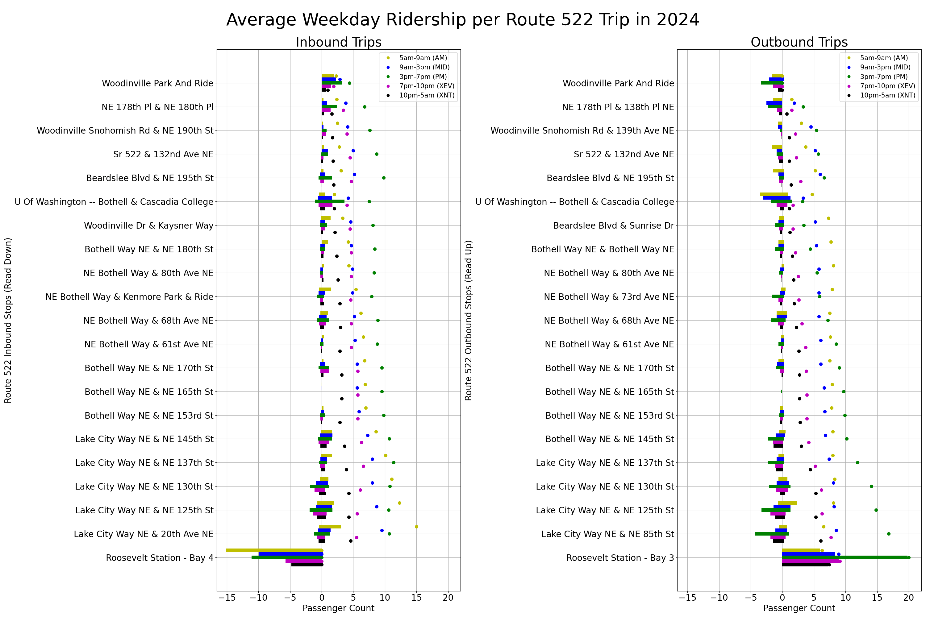
Sound Transit Route 522 travels inbound from Woodinville to Roosevelt station, primarily via SR-522. This express service has stops in Bothell, Kenmore and Lake City. Outbound trips travel in the reverse direction. In June 2025, Route 522 had 2,318 average weekday boardings.
The plots below show the average weekday ridership by stop in each direction, color-coded by time of day. For a more detailed breakdown of how the plots are set up, please refer to the How to Read the Plots section of the article discussing Route 70.
Average Weekday Ridership per Route 522 Trip: September 2024 to March 2025. “Inbound” is toward Roosevelt station; “Outbound” is toward Woodinville P&R. Click the plot to view at full-resolution in a new tab.
Route 522 is an essential Link connector for Lake City, UW Bothell, and Woodinville. Some observations:
Yesterday marked the 25th anniversary of Sounder, Sound Transit’s commuter rail service. On the morning of September 18, 2000, the first Sounder trip departed a temporary station in Tacoma and headed towards King Street Station in Seattle. Along the way, the train stopped in Sumner and Auburn. A second trip ran later in the morning, and two trips back to Tacoma ran in the afternoon.
Over the past 25 years, the Sounder network has grown to include 2 lines, 12 station, and nearly 83 miles of track. Let’s take a look at a few key milestones in Sounder’s history.
EMD F59PHI Locomotive #911 at Lakewood Station
September 18, 2000: Sounder begins revenue service with two daily round trips between Tacoma and Seattle.
February 5, 2001: Stations open in Puyallup and Kent.
March 12, 2001: Tukwila station opens.
September 30, 2002: A third daily trip is added.
September 15, 2003: The temporary station in Tacoma is replaced by a platform at Tacoma Dome Station’s Freighthouse Square.
December 17, 2003: Sound Transit and BNSF agree to a perpetual easement agreement to Burlington Northern tracks between Seattle and Everett.
December 21, 2003: The North Line begins service with a Sunday train for a Seahawks game. The line had one stop in Edmonds.
December 22, 2003: Regular North Line service begins with one daily round trip from Everett to Seattle.
June 6, 2005: A second daily North Line trip is added.
September 24, 2007: The South Line adds its first ‘reverse commute’ trip, traveling from Seattle to Tacoma in the morning and Tacoma to Seattle in the afternoon.
May 31, 2008: Mukilteo station on the North Line opens.
October 8, 2012: The South Line is extended to South Tacoma and Lakewood.
March 23, 2020: Service on both lines is cut in half, the South Line is cut to eight daily round trips and the North Line is cut to two daily round trips.
September 18, 2021: The North Line and South Line are renamed to the N Line and S Line, respectively.
September 19, 2022: S Line is fully restored to pre-pandemic service levels.
September 16, 2024: N Line is fully restored to pre-pandemic service levels.
The Link 1 Line runs between Angle Lake in SeaTac and Lynnwood via Tukwila, Seattle, Shoreline, and Mountlake Terrace. In May 2025, the 1 Line had 105,586 average weekday boardings.
The 1 Line initially opened in July 2009 and ran between downtown Seattle (Westlake) and Tukwila. Since then, it has expanded north to the University of Washington in 2016, Northgate in 2021, Lynnwood in 2024, and south to SeaTac in December 2009 and Angle Lake in 2016. The Federal Way Link Extension is expected to open later this year.
The ridership data discussed in this article is just a snapshot of the current system. Link is still a growing system and many of the non-Link transit projects being built in Puget Sound will have a direct or indirect impact on ridership over the next few decades. The methodology behind the data shown below is discussed in the first comment below the post.
Average Weekday Boardings Per Station
The plot below shows the average weekday boarding count by station in each direction in May 2025. Southbound boarding counts are shown on the left and northbound boarding counts are shown to the right. The alighting count for a given station is similar to the boarding count in the opposite direction.
Average 1 Line Weekday Boarding Counts in May 2025
The 1 Line ridership patterns show that the highest ridership occurs between downtown Seattle and Northgate. U District has the higher number of southbound boardings and SeaTac/Airport has the highest number of northbound boardings. All stations north of the Montlake Cut (UW and above) have more southbound than northbound boardings. All stations south of UW have more northbound passengers.
Pike Place Market’s car-free pilot was recently extended until Spring 2026. During this time the Market will create a comprehensive street management plan that will take effect before the FIFA World Cup in June. We don’t know what the final plan will be, but it may result in Pike Place becoming the third pedestrian street in Seattle. Occidental Avenue was pedestrianized in 1971, and a half block of Pike St was pedestrianized in 2023.
Pike Place outside of the Market. Do we need cars here?
Pedestrian streets significantly improve the local environment of any neighborhood by creating space for people to meet, eat, and relax. Study after study has shown that pedestrianizing an area increases foot traffic and spending at local businesses, while creating a cleaner and safer environment. Seattle needs more permanent pedestrian spaces.
Seattle Street Railways 1896 by Harry Foesig. Map scan by Andrew Filer.
Seattle has a long history with rail public transit. This map was drawn by Harry Foesig and published in Leslie Blanchard’s 1968 book, The Street Railway Era in Seattle: a Chronicle of Six Decades. Despite the map depicting Seattle 129 years ago, many of the routes shown are still served by Metro routes today.
RapidRide D runs on 15th Ave, Elliott Way, and Mercer St.
Westlake Ave is served by Route 40.
Eastlake Ave now has Route 70, soon to be the J Line.
RapidRide G covers most of Madison, Route 11 covers the eastern third.
The Central District had two routes similar to today’s routes 3 and 4.
The Seattle Department of Transportation (SDOT) is wrapping up two projects in Pioneer Square that will make traveling in the area easier for everyone. SDOT is hosting a celebration during the Pioneer Square Art Walk today from 5-7pm at 3rd Ave S & S Main St.
Crews add the final touches to the 3rd Ave S & S Main St bus stop
SDOT’s 3rd Ave S & S Main St project redesigned 3rd Ave S between Yesler Way and S Main St. The street now has wider sidewalks, a smoother roadway surface, and improved pedestrian lighting. The bus stop at 3rd Ave S & S Main St is quite busy, serving routes 7, 14, 21, 36, 40, 70, 124, 131, and 132.