Ed Murray on Light Rail Expansion

seattlesubway.org

There are probably solid practical reasons to favor a “regional approach,” and I’m inclined to view his campaign with an open mind, but Mayoral candidate Ed Murray’ s statement to PubliCola doesn’t make any sense to me:

Here’s Murray on Mayor McGinn’s push to build light rail from Ballard to West Seattle.

We can’t afford [light rail from Ballard to West Seattle] by ourselves. There are probably things we could do as a city … that would feed in and make the light rail system work.The city is all gridlocked. More light rail is great, but that’s got to be built on the regional level.

As Sen. Murray is no doubt well aware, Sound Transit’s subarea equity mean that in any financing plan — “regional” or otherwise —  funds for any Ballard-to-West Seattle segment come from Seattle, Shoreline, and Lake Forest Park. The contribution of the two suburbs matters (on the order of 10% of the total) but the money all comes from the same place, save for any federal contribution. I doubt that Sen. Murray is making a fine-grained judgment that Shoreline and Lake Forest Park cause the subarea to cross the threshold into affordability.

Seattle may not have adequate current revenue authorization to open the whole line, but then neither does Sound Transit in the first half of this century. The right answer, in my view, is whatever it takes; with the region if they’re willing to come along, as they have been in the past, or seeking its own plans if not.

The Murray campaign did not reply to my request for clarification.

A Pillow of Cement

Cement Pillow at 11th & Clay, in Portland.
“Pillow”-type curb extension at 11th & Clay, in Portland.

Last year, I took a tour of Portland’s Greenways with Seattle Greenways. I learned a great deal about traffic safety, calming and diversion from the Portland’s traffic engineers, although most of it was more relevant to creating good bike infrastructure, rather than transit. There was, however, one idea which struck me as having immediate applicability to transit at certain places in Seattle, namely an experimental variant of a curb bulb using a concrete pillow, as shown above.

SDOT’s website defines a curb bulb as “a radial extension of a sidewalk at a corner or mid-block location used to shorten the crossing distance for pedestrians, provide access to transit, and expand the landscape/furniture and walkable zone … The restricted street width provides a visual cue to motorists, encouraging them to travel more slowly at intersections or midblock locations with curb extensions. Turning speeds at intersections can be reduced with curb extensions” by forcing cars to make sharper turns.

There are some situations, though, where the standard style of curb bulb won’t work, or the existing curb arrangement is not working, because the intersection’s angle is acute or the approaching roads are narrow, and it is frequented by long-wheel-base vehicles like semi-trucks or transit buses. For those vehicles, it may be difficult or impossible for the driver to consistently arrange to make the turn without swinging into oncoming traffic or riding over the curb.

The photo above shows a traffic-calming measure on a pedestrian- and bike-oriented Greenway street which is also used by semi-trucks to access property to the left of the photo. With a normal bulb, these vehicles would routinely be driving all over the curb. The solution PBOT is experimenting with is to fully extend only the straight part of the curb, then install a concrete “pillow” that’s shaped like a speed bump in the radial part of the curb. While drivers of smaller vehicles receive similar cues to slow down as with a normal curb bulb, drivers of longer vehicles can make the turn with only a small bump under the rear axle.

More after the jump. Continue reading “A Pillow of Cement”

News Roundup: 520

2nd & Yesler, c.1922 (Rob Ketcherside/Flickr)

This is an open thread.

Northgate/105th: Another Epic Repaving Project

Bus stop at 105th & Stone
Bus stop at 105th & Stone. Transit and pedestrian facilities are substandard throughout this area.

Everybody remember the recently-completed repaving of 85th St, which screwed up the 48 schedule for much of last year? Well, because that was so much fun, we’re gonna do it all again! Starting this spring, using money from the Bridging the Gap initiative, SDOT is going to repave Northgate Way/105th St from Meridian to Greenwood; construction will continue for about a year. As Northgate/105th is the only arterial in this part of the city, no viable alternative route exists, so inbound Route 40 trips will take a substantial and unavoidable hit to reliability that will be felt by riders throughout the route. Riders to or from Northgate or North Seattle Community College will be impacted even more.

There is, however, light at the end of the tunnel for transit.  According to SDOT’s Bill Bryant, all the intersections between Greenwood and Meridian are being considered for Transit Signal Priority, which will (I suspect) likely be of the “hold or advance green” variety. While Northgate/105th isn’t a particularly pedestrian-friendly street — it’s fast and wide without many signals — those same qualities, coupled with the lack of street parking, and the addition of TSP, could make it a very fast and reliable pathway for surface transit.

More after the jump. Continue reading “Northgate/105th: Another Epic Repaving Project”

Stuff Bus 42

By the Author
Martin/Flickr

In just over two weeks, a day will come which many readers and authors of this blog have long awaited: the last, lonely trip of Metro Route 42. Once a major route serving Martin Luther King Way, with the third-highest ridership in Southeast Seattle, it was rendered superflous by the opening of Central Link and extension of Route 8 to Rainier Beach. Metro thus proposed killing this route in its entirety, but in a now-all-too-familiar example of excellent political organizing used to spike a smart idea, one local community organization — the Asian Counseling and Referral Service — scared the King County Council into keeping a gutted version of the route, which happened to be just long enough to connect the ACRS’s two properties.

The 42 limped on as a shadow of its former self, with practically nonexistent ridership. Metro attempted again, last year, to delete the 42 as part of a round of cuts to “worst of the worst” routes, and ACRS used the same tactics to delay the deletion of the route, and force Metro to undertake a program of “intense outreach” to Southeast Seattle. This consumed lots of staff time and produced lots of interesting reports which highlighted some problems with bus facilities, public safety, and customer communication, but failed to uncover anything remotely resembling a good reason to keep the 42 (although it did give me an excuse to write about splitting Route 8 and improving Route 106).

But enough of this history. The bell tolls; the shakeup is at hand. The last trip of the 42 must not be lonely. In death, we shall give Bus 42 what it had not in life: riders; many riders.

The next Seattle Transit Blog meetup begins at 4:43 PM on Friday, the 15th of February, at 3rd Ave S & Main St. We will board the last outbound 42 to Columbia City, disembark at Rainier & Alaska, and repair to the Columbia City Ale House for drinks. (Be a few minutes early, or check OneBusAway, in case the bus is ahead of schedule). The Ale House is 21+ (sorry!), but I’ll also be at Caffe Vita, just a block away, from about 4 PM, for those of you who can get away early and want to chat for a while. If you don’t work downtown or can’t get off work in time, you can join us at your convenience by using one of the many other vastly superior transit services (Link, 7, 8, 9X, 50) which can get you within walking distance of Columbia City.

This is an informal meetup; we don’t plan to have a speaker, but experience suggests that we can all have a great time both with or without one. More meetups with awesome speakers are tentatively in the works for spring. Please RSVP in the comments so we can get a rough headcount, and watch for a reminder post with confirmation of the venue closer to the time.

Transit Report Card: Seoul (I)

hanyang univ. at ansan
Hanyang University at Ansan, Line 4

I’m continuing STB’s longstanding tradition of the Transit Report Card series, where a writer will review the transit and land use picture of another city after a visit.  I’m pleased to be kicking off the return of the series by thoroughly reviewing Seoul, South Korea.  Instead of assigning letter grades, I’ve opted to focus on in-depth observation and qualitative analysis.  You’ll also notice that I’ve deviated from the original subheadings in favor of new ones, which more appropriately classify the bits and pieces of my review.

Because the transit system is so vast, I’ll take the liberty of breaking up this report card into two parts, the first of which will cover the city’s planning background, and a general overview of the system development and design.  Part 2 will focus more on the rider perspective and cover things like fares, passenger amenities, local transit etiquette, etc.

Continue reading “Transit Report Card: Seoul (I)”

Land Footprint – Update

In the first post in this series, there were some great recommendations on how to change the land footprint graph.  In my original version, I graphed the number of blocks in our region that fall into a given land area per person.  The suggestion was to instead plot the number of people living at a given land area per person.  I’ve taken it a step further and plotted percentage of people living at a given land area per person.  For example, 0.52% of people in our region have a land footprint of around 600sf per person, which corresponds with the Capitol Hill picture below (the bottom left). Graphing using the percentage of total population will allow me to compare regions of different size on the same graph, which will be useful in my next post in this series.

Seattle Density Curve w pics percent

Transit Agencies Unite In Olympia: “Keep Transit Moving!”

KTMEver since the 2000 legislature revoked our voter approved car tab revenue, transit funding has been unreliable. Before then, transit agencies across the state relied on a combination of more volatile sales tax and less volatile (and more progressive) Motor Vehicle Excise Tax, or MVET, to operate service. Now, with only sales tax, funding fluctuates wildly with the economy, and our bus service is being gutted.

Imagine if all our highways and large arterials had to be closed a few hours a day, or even one day a week! When transit service is so dramatically cut, the elderly, the poor, the visually impaired, and many others face a similar situation, cut off from jobs, family, services, much of the world.

This year, with such a universal threat, our transit agencies have come together to present a unified demand.

An earlier legislature chose to cut the MVET. This legislature must now step up to solve the problem, and the solution is easily within reach. Our state only provides 2% of our transit agencies’ budgets – compared to a national average of 17%. The state will be relying on Puget Sound voters to pass a transportation package, and we’ve spoken before: We don’t want wider highways. We want more fast, reliable, high capacity transit.

Now, a line in the sand has been drawn. A statewide package must contain $400 million annually in direct transit operations funding, to be apportioned to agencies by an already established formula. That’s the level that will shore up Pierce Transit, keep Metro from having to make huge cuts, and even assist Sound Transit a tiny bit in implementing light rail. As part of a statewide package, direct funding would avoid fighting every local battle individually, and provide a rock for the next economic crisis.

The “Keep Transit Moving” request is worth a read. 31 agencies across the state have one ask. It’s still a little timid – allowing for 25% of a smaller package if the $400 million/year isn’t in the cards. But the Republicans in Olympia would provide less at their peril – major cuts in Pierce and King counties in 2014 would bring angry voters to the polls, leaving them little chance of keeping their tenuous grasp on power.

Olympia must fix the problem their predecessors created by cutting the voter-approved MVET. The resilient, sustainable, efficient transportation system of the future starts with well funded mass transit.

Book Review: The Great Society Subway

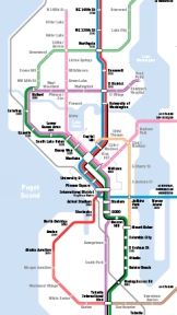
Although I’m certainly biased in favor of my hometown, in my opinion the DC Metro is the finest American rail transit system of the automobile age. Fast, extensive, and fully grade-separated, Metro has utterly transformed land use throughout its region. Thirty five years after its opening, the Nation’s Capital is unthinkable without it.

Metro is also the subject of a new(ish) book by Zachary M. Schrag, The Great Society Subway. The book takes the story of Metro from its origin in freeway fights of the 1950s through the final completion of the initial plan in 1990s.

If you’re familiar with the geography of the area and the system, it’s interesting to learn the story of how the lines ended up where they are. A salient fact about Metro is that it was envisioned as an alternative to a web of inner-city highways, rather than a supplement to them. Early in the book, the alphabet soup of shifting planning agencies and parade of old white guys gets a little tedious, but once WMATA (the agency’s name to this day) is formed, things pick up a bit. Aside from the narrative quality, three things stuck out for me.

The first is the shifting valence of the neighborhood activist, fighting freeways and later fighting rail lines. It reminds me of the shared reverence for Jane Jacobs, who was after all two things: an advocate for urbanism and pedestrians over the car, but also a defender of the status quo against the force of the establishment and professional planning. In cities like Seattle where the status quo is heavily auto-oriented, both sides can find inspiration in her story. In Washington’s case, underground rail lines proved less objectionable than elevated freeways, although Schrag has some pretty appalling tales (look up “Yuma Street” in the index for a particularly egregious example.)

Second, I was especially interested in the comparative experience of various jurisdictions with land use. Arlington County, Virginia and Montgomery County, Maryland thought early about where they wanted the lines to go and how it would shape those areas, and they ended up with fabulous mixed-use neighborhoods. Fairfax County, VA did not, and ended up with single-family neighborhoods and parking along the Orange Line, while it completely missed the rapidly growing job center of Tysons Corner.*

Finally, it’s interesting what struggles are still interesting today and which seem petty. The aforementioned battles over routing and land use reflect legitimate differences in values and still have significant impacts today. What hasn’t aged as well is concern over cost. The Metro was not built in a particularly austere environment, but decades later compromising quality for what seem like quaint sums today seems particularly shortsighted. The struggle for $65m elevators to make it wheelchair-accessible is a particular low point. But in general costs were allowed to spiral ever upwards to preserve the scope and the region is better off for it.

If the Washington Metro is special to you, you should definitely read this book. If you’re interested in how in two decades we might look back at the rail and land use battles being fought today, the last two-thirds of the book are well worth a read.

* Tysons is finally getting rail service this year with the new Silver Line.

Roosevelt Station Construction Open House

Roosevelt Utility Work Map

At 6:30 PM on Tuesday, January 29th, at Roosevelt High School, Sound Transit is hosting a construction open house, to inform the neighborhood about upcoming work in 2013 and early 2014. Demolition is drawing to a close in the station area, and the next phase is utility relocation and power-line work throughout the neighborhood.

These construction open houses don’t usually discuss substantial design or policy issues, and the design for Roosevelt Station is probably close to its final form by now, but even of you don’t live in the neighborhood, it’s a good chance to talk to staff and hear how the project is progressing. Roosevelt Station, along with the rest of North Link, is due to open in 2021.

CT Hopes to Fund its Future

Oran/Flickr

Last month Community Transit produced the draft update to its six year Transit Development Plan. Their vision is an appealing one: prioritized transit corridors that travel through intensively used land. However, CT has (hopefully) completed a period of austerity that cut 37% of its service and over 200 employees, including the abolition of all Sunday service, at the cost of 3m annual boardings (off the 2008 peak of 12m).

The bad news is that their economic models predict revenue growth no faster than operating cost, meaning service levels will remain flat.* The near-term (2017)  goal is therefore both ambitious and limited – to recover the 2008 ridership high without any additional service, but through a 25% increase in productivity.

CT says it’s already at its most productive per revenue hour in its 36-year history. The plan doesn’t have a clear path to wring still more savings out of the system, as a lot of the least efficient service has already been cut. But the hope is that a combination of further emphasis on productivity in service allocation, more capacity through double-tall buses and parking spaces, and ever more intensive development along priority corridors will get the agency there.

Continue reading “CT Hopes to Fund its Future”

News Roundup: Disarray

Sound Transit

This is an open thread.

Seattle Should Look to Phoenix for SoDo Solution

Image courtesy of Valley Metro

With this week’s news, it is highly likely a new arena will be built in SoDo.  Currently, the strongest objections to the arena center around traffic impacts to the Port and neighborhood businesses.  With that in mind I was very disappointed to see that the early design guidance released Tuesday estimates 81% of visitors arriving via automobile and only 6% and 3% coming by rail and bus respectively (page 7).

To reduce traffic impacts, Chris Hansen’s group should strike a deal with Sound Transit, and possibly Metro, similar to the Phoenix Suns’ agreement with Valley Metro, their transit provider.   Under the Rail Ride Event program tickets for home games and other events at the US Airways Center include the cost of train fare in their ticket price.  “Event tickets are valid light rail fare for the day of the event only, for the period four hours prior to the event until the end of the transit day.”

The program was so successful that after a one year pilot it was renewed for 5 more years in 2010. “Under the agreement, the Phoenix Arena Development Ltd. Partnership, the operator of US Airways Center, pays Metro 31 cents for each person attending an event. Revenue received by Metro has averaged $41,194 per month since the program’s inception, covering more than the fare expected from event ridership.”  Not only does it provide income to Valley Metro, but the Suns and the arena use the program as a promotional tool.

In 2010, 11% of Phoenix Suns attendees used light rail to get to the game.  Considering our land use and transportation system, there is every reason to believe the SuperSonics could do much better, especially with both U-Link and Angle Lake Station (with it’s 1100 parking spaces) coming on line in 2016.  It won’t solve the traffic problem completely, but it could make a large dent, and $.31 a ticket seems like a small price to pay to help alleviate neighborhood traffic worries.

Center City Connector Open House Feb 6

City Center Corridors Alignment Options V3The high-capacity transit corridor known as the Center City Connector — discussed previously here and here — will be just 1.1 miles long.  But it’s an important 1.1 miles! Running between King St. Station and Belltown, the connector will provide the spine for potential future extensions to Queen Anne and the North End.

Federal grant money to move forward with the project was secured last fall, and on February 6 SDOT is hosting an open house to kick off the project.  Stop by to get the details.  Before you go, you may want to prepare yourself by reading this brief corridor analysis from the Transit Master Plan (pdf).

Improving Transit Facilities on Leary

Route 40 at 36th & Phinney

A couple of weeks ago, I wrote about making transit work better at the two stops at Fremont & 34th. Those two stops are among the busiest, and most readily improvable, stops in north Seattle, and I was happy to receive an email from the Mayor’s office last week indicating that work was in progress along the lines I described.

There are, however, quite a few more valuable, but low-cost investments that can be made on the stretch of Leary Way and 36th St between Fremont and Ballard to improve transit speed and reliability, and rider comfort at stops. In particular, there are four stops in Fremont which would really benefit from bus bulbs, which prevent delays due to the bus having to turn out of traffic.

Map of stops on Leary
Sidewalk outside Norm's
Sidewalk outside Norm’s

Ideas for improvements, after the jump. Continue reading “Improving Transit Facilities on Leary”

CT November 2012 Performance Report

ct_ridershipThanks to alert reader Reyes Ojeda, we have the latest Community Transit System Performance Report, which has tons of route ridership and park-and-ride utilization data.

Year-on-year boardings on the bus system were down 7.6% on a 21.6% decline in revenue hours, a consequence of cutting the least productive service. The format of this report reveals that CT is thinking clearly about what it is trying to achieve with its bus service.

In addition to vanpools and paratransit, bus service is split into five classes: Bus Rapid Transit (Swift), corridor service, local feeders, suburban/rural lifeline service, and commuter buses. Swift blows all the other routes away with an average of 4,144 weekday and 2,486 Saturday routers, but it’s actually its shadow, the 101, that is most productive per revenue hour.

Continue reading “CT November 2012 Performance Report”

Metro Responds: Route 16 and the Seattle Center

Photo of Metro Director of Service Development Victor Obeso
Metro Director of Service Development Victor Obeso

by VICTOR OBESO

Bruce Nourish recently voiced his opinion about Metro Transit’s Route 16 – a long-time Metro route that has been serving Fifth Avenue North by the Seattle Center for many years.

Despite his claims to the contrary, we care deeply about our customers. Readers and riders know there are always trade-offs when designing a transit route and schedule. We work hard to balance riders’ interests and carefully constructed guidelines as we evaluate potential changes – and key among them is customer feedback. We also must respond to changing real-world conditions, including massive multi-year construction projects that affect service and travel times.

Route 16 has been providing excellent access to events and activities at the Seattle Center for many decades. However, Metro recognizes times have changed. Traffic has grown worse in the area and ongoing construction projects have further increased the time it takes for Route 16 to serve the area. At the same time, major increases in employment in the South Lake Union area are creating more demand for this route to shift toward the east to provide more convenient access to South Lake Union. But there are still many riders each day that enjoy the very convenient access to the Seattle Center that Route 16 provides.

The route serves thousands of riders each day. Based on analysis, the indirect path fails Metro’s route directness guideline in one direction (outbound +7 minutes for through customers) but meets the guideline (inbound +3 minutes for through customers). This illustrates the tradeoffs associated with making a decision to change the route or not. One might suggest that the inbound routing serve Fifth Avenue North while the outbound routing use Aurora Avenue North. But this would violate another Metro Service Guideline that calls for easy to understand services that have predictable routings. By splitting the route to travel on Fifth Avenue North in one direction and Aurora Avenue North in the other direction would make it difficult to understand for riders and might impact overall ridership negatively.

Metro, in the past, has considered moving Route 16 off of Fifth Avenue North in order to remove the route from the severe traffic and delays but public feedback was mixed and no changes were made. When riders of the route were asked about a change to Aurora routing via on-board surveys in 2002, over half of the respondents indicated a preference for the Seattle Center routing. This is likely because many riders who use this route most often to get to or from work downtown might also benefit from the direct Seattle Center routing for events.

However, we do recognize that the upcoming Mercer Street project and Alaskan Way Viaduct replacement construction will continue to impact the area and perhaps further delay service. Additionally, long-term the east-west street network between Denny Way and Harrison Street is slated to be rebuilt allowing customers to more easily access bus routes on Aurora Avenue North.

Due to the planned Mercer project, Metro intends to change the existing routing on Fifth Avenue North to Aurora Avenue North in order to avoid street and lane closures and to provide more reliable service to the large number of riders traveling between North Seattle and downtown Seattle. We understand that this would negatively impact the riders who travel between North Seattle and Fifth Avenue North so this change is not taken lightly.

Victor Obeso is Director of Service Development at King County Metro.

Seattle’s Terrifying Maintenance Backlog

SDOT Chart of Cost vs Time illustrating cost of deferred maintenance

A reader sent in this recent presentation from SDOT’s Bridge Maintenance Program, and it’s pretty grim reading if you care about the quality and serviceability of Seattle’s streets and bridges.  Some of the top line numbers have been out there for a while, but they bear repeating:

  • SDOT’s deferred maintenance backlog was $1.8 billion in 2010.
  • To “break even”, and prevent the backlog from growing, the city needs to spend about $190 million per year on maintenance.
  • The city is currently spending $50 million per year.
  • The Bridging the Gap program does not come anywhere close to reducing this backlog.

This reinforces a point which Martin and guest contributor Alex Broner made recently: there is an effectively infinite amount of work which could be done in Seattle with 18th-Amendment encumbered gas tax money to bring our roads back into a sound condition. Gas tax, as Martin has pointed out, is extremely efficient to collect, provides an excellent incentive to consume less fuel, requires no new legal or bureaucratic structure, and carries no privacy concerns.

In a rational universe, voters and political leaders would understand that fixing existing problems is a high priority, and would move to address them as such; instead, leaders promote shiny new projects that are almost certainly less essential, and voters continue to reward them for doing so. Road maintenance spending has become like bus stop consolidation or route restructuring: work that’s crucial to our future as a dense and growing city, but is prevented by the direct democracy and political culture of our present.