
Back in December we reported that the Office of the Waterfront would undertake a Supplemental Draft Environmental Impact Statement (SDEIS) to study removal of the planned bus lanes on the future Alaskan Way. There was some confusion at the time because no organized groups were agitating for such an outcome, and that all parties had generally agreed on the merits of transit priority. But the number of understandable complaints about the overall roadway width from bicycle and pedestrian advocates exceeded a threshold that triggered SDOT to study a narrowed footprint. From our followup post:
Office of the Waterfront Director Marshall Foster said the total number of comments asking for a narrower roadway hit “a tipping point” that forced the City to formally respond to their request, necessitating a SDEIS that studied a narrower roadway. However, Foster said the funding agreement between the State and the Port explicitly codifies two general purpose lanes in each direction, effectively prohibiting the City from studying reducing those lanes in the SDEIS:
Section II, A, 5: The Central Waterfront from Pine Street to Colman Dock will have two lanes in each direction plus a turning lane; the segment south of Colman Dock will have 3 lanes in each direction plus a turning lane.
So the City is in the odd position of being required to study a narrower channelization because enough of the community asked for it, but since the only mode not explicitly protected in its right-of-way allocation is transit, the City will study eliminating transit priority even though neither the City nor advocacy groups see that as a preferred outcome. Isn’t process fun?
Well, that SDEIS has been published, and comments are due May 18. Read the full document here, or the Executive Summary here. And the results are a slam dunk. The SDEIS shows that removing the bus lanes would worsen travel times for transit, general purpose traffic, and freight.

The SDEIS studied a new Alternative 2 that removes the bus lanes, adds a limited amount of street parking, reduces the roadway footprint by roughly 15% (from 88′ to 75′), and adds vegetation by widening the landscaping strips adjacent to the sidewalk and cycle track. There would be pullouts on the south side of the roadway for buses and/or street parking, with queue jumps added for buses to reenter the general purpose lanes. The narrower footprint would reduce walking time across Alaskan Way by approximately 7 seconds.
Vehicles
Alternative 2 would increase general purpose travel time by about 1 minute in each direction:
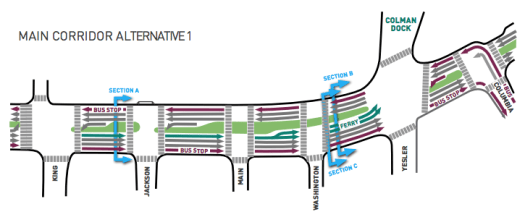
Main Corridor Alternative 2 would provide improved or additional facilities for motor vehicles, transit, bicyclists, and pedestrians in the study area compared to the No Action Alternative. However, traffic operations and intersection delays would be worse compared to Main Corridor Alternative 1. Under Main Corridor Alternative 2, removal of the transit-only lane and introduction of transit queue jumps at Yesler Way (southbound) and S. Main and S. King Streets (northbound) would reduce the amount of time the signal cycle is green for northbound and southbound general-purpose traffic. The reduced green time would result in worse travel times for all users, including transit, through the overall AWPOW study area for Main Corridor Alternative 2. These delays would cause greater congestion on Alaskan Way with Main Corridor Alternative 2 and result in traffic diverting to nearby streets. In addition, the lack of dedicated transit lane with, Main Corridor Alternative 2 would have reduced transit speed and reliability compared to Main Corridor Alternative 1.

Transit
Removing the bus lanes has a worse proportional impact on transit. Even though transit will only use the half-mile strech from Dearborn to Columbia, delays would be double what general traffic would incur over the entire corridor. Bus trips would be roughly 2 minutes longer, reducing average speed from roughly 15mph to 8mph.
Both Main Corridor alternatives would improve conditions for transit compared to the No Action Alternative, but these improvements would be substantially greater under Main Corridor Alternative 1 than under Main Corridor Alternative 2. Main Corridor Alternative 1 would improve transit speed and reliability by providing transit-only lanes on Alaskan Way between S. King Street and Columbia Street, and a transit-only, southbound left-turn lane at the intersection of Alaskan Way and Yesler Way. Main Corridor Alternative 2 would not include these improvements, but would provide transit queue jumps at the intersection of Alaskan Way and S. King Street (northbound), S. Main Street (northbound), and Yesler Way (southbound). When the street grid is saturated during peak times or special events, buses would be caught in traffic longer for Main Corridor Alternative 2 compared to Main Corridor Alternative 1.

So if the SDEIS shows only a 7-second benefit for walking time while degrading travel times for all other users, Alternative 1 seems clearly preferable. Please comment by May 18 and speak up for transit priority. Though an 88′ street will admittedly feel anti-urban in many ways, the corridor’s 30,000 transit riders deserve a fast, reliable trip.
Is the ROW too narrow to support 2×44 ft one way lanes, with something green and walkable (and wider) in the middle? Both alternatives appear to show green and unwalkable.
Alternatively, how about submerging the colman dock turn lanes in the bay?
People trying to get on and off the ferry are terrible drivers.
I don’t see anything that requires the two lanes in each direction to both be general purpose lanes. The way I read it, a general lane plus a bus lane in each direction complies.
This goes back to my comment on the central city connector – just move the buses to 1st and have them share the ROW with the streetcar (which is getting Full TSP and dedicated lanes).
That way we have very good frequency on 1st (every couple of minutes), and it avoids making Alaskan Way some giant 8 lane monstrousity (it would be a marginally better 6 lane monstrousity).
The result though will be one of these two options. So choose the one with transit lanes.
The bus lanes are for regional service to and from everywhere south and west of East Marginal Way and Spokane. “Put[ting] the buses on First Avenue” would significantly degrade that service and run a “wall of buses” throughPioneer Square. Neither is a good thing.
Continuing.
Running the buses on First Avenue instead of Third Avenue north of Columbia is a fine idea and should be studied further. But keep regional service off of First through Pioneer Square.
It might be an 8 lane monstrosity, but keep in mind that a portion of those lanes are essentially dedicated to parked cars that move every half hour or so, as they are auto staging lanes for the ferry. They aren’t real traffic lanes.
Besides, when the ferries are loading and unloading, they set the traffic lights so that nobody else (no pedestrians, no other auto traffic, nobody) interferes with the movement of that traffic, so it isn’t as if it is a particularly pleasant experience attempting to get across that part of Alaskan Way anyway.
Whether they go through downtown on 3rd or 1st, the buses still need to get there from 99.
There should be bus lanes.
Stephen, how do you get people along the Waterfront itself? From Union Street north, the cliff between the waterfront and First Avenue only gets higher.
Mark
The waterfront needs a route of it’s own as well, espcially at the north end of downtown where the elevation difference is huge.
I have a crazy idea. Let’s put some tracks down, hang a power wire overhead, and run vintage streetcars down the waterfront. Or maybe not, tourists hate vintage trolleys and nobody really needs transit on the waterfront.
Nah. Tourists will leave more money behind if they are forced to use bicycle taxis.
“the City will study eliminating transit priority even though neither the City nor advocacy groups see that as a preferred outcome. Isn’t process fun?”
I have to blame the advocacy groups a bit, though. They narrowly advocate their own positions without regard for how that affects other stakeholders. What did they think would happen given the constraints? We continue to see narrow interest group mentalities from many single-mode advocates that overshadow the pragmatic majority that uses several modes at least somewhat regularly.
This sudden obsession with wide streets is quaint. We have many far worse streets for pedestrians than the future Alaskan Way. I’d argue that a highly-controlled newly-built street with clear lane markings is going to be a lot safer than the poorly marked, one lane (or is it two) streets that are all over the city.
To be fair, nobody really knew about the requirement of two GP lanes until the “no transit lanes” alternative was announced. Pedestrian and bike advocates weren’t advocating to get rid of a lane of transit, they were advocating to get rid of a lane, which everybody assumed would be a general purpose lane (there was no noise about it here when ped groups were arguing for a narrower roadway).
Then we all learned about the absurd requirement of two GP lanes in each direction, and the bike/ped people pretty much said “no wait, we didn’t mean that!”
I wouldn’t really blame process, either – the “process” inducing thing here is the mandatory trigger, which lends power precisely to us, the advocate types who write to our boards and politicians, thinking we’ve got a better idea. Think how many here would love if ST had mandatory triggers so we could get a Metro 8 route studied if we raised enough stink, or no-private-parking included in the alternatives for suburban link segments!
Pretty much exactly right on, EHS. Lots of conversations with TCC and others regarding transit lanes, and no one had any idea the only option they could study was removing the transit lanes. The whole thing is a cluster, truly; Zach’s last sentence is about right on. 88′ of right-of-way will not be the boulevard we wanted, but given the need to run transit through the corridor *and* the extremely unfortunate insistence on ferry parking and 2 GP lanes…
Good update. When the “new” alternative first came out, people were (very) quick to react that forces were against transit, and pro-gp traffic. Clarity followed (and continues in this update), that the option to remove the transit lanes was the only option for study. For people that complain about the two lanes for ferry traffic – recall that Washington State Ferries always has historically had two lanes of queueing – at least up until the Tunnel and Seawall projects changed everything. The two holding lanes were tucked beneath the AWV on the east side of Alaskan Way, so those lanes have always been there. This segment of street is wide, but if you look at the proposed design north of Colman Dock (which is where people actually go when they visit the Waterfront), the street is 4/5 lanes wide.
We have many far worse streets for pedestrians than the future Alaskan Way.
Many? Really — many? I think I can count on one hand the streets that can even compete for ugliness in Seattle (unless you count the freeways)
Aurora — Sure. Ugly. Except it is essentially the same (two general purpose lanes both directions, and a bus lane both directions). There are turns lanes as well (but no double turn lanes because there is no ferry).
Lake City Way — Arguably the ugliest street in town. Except that it will be narrower than this. Two lanes each direction, with a turn lane.
Rainier Avenue — Same thing as Aurora.
Basically, they aren’t worse. Or if they are worse, it is the speed that makes them worse. But while all these streets are terrible when cars are moving fast, they all have sections where the cars move very slowly. So the only good thing about the future Alaskan Way is that traffic will move slowly through there. Fair enough. But remember, we are in the process of spending billions on a tunnel to move cars though the area, and one of the big selling points for that project is that it would make the area really nice. I don’t think they had “it will be great, just like the slow parts of Aurora” in mind.
With that being said, I’m fully in favor of adding the bus lanes. We need to stop pretending that this area will be the pedestrian paradise that some hoped it would. Once you decide to have two car lanes going each direction, those days are over. You might as well run the buses. The buses aren’t nearly as obnoxious as the cars, as they operate responsibly (not as loud as a Harley, nor as stinky as a diesel truck that needs a tune up, nor as fast as an idiot changing lanes). Pedestrians will deal with the mess as best they can. The nice part is that if they take a bus, the bus won’t be stuck in traffic.
Please also advocate for a station stop in the Pioneer Square area, not just an express route to Columbia Street.
There are stops at Main northbound and at Jackson southbound for Pioneer Square riders.
Why not open the transit lane to freight in a two lane configuration? Three lanes in each direction does seem excessive if the goal is to better activate the waterfront.
There is NO “WATERFRONT” south of Coleman Dock. It’s a derelict pier now being used for Bertha’s spoils.
So a waterfront poised for redevelopment.
No, redevelopment would threaten our precious maritime jobs!
Sincerely,
Someone still salty about the arena
Please do not advocate that trucks and buses share the inside lane.
The port pushed for a got a deep bore tunnel.
The trucks do not need priority to bypass that tunnel.
They can sit in traffic like every SOV, or take the empty tunnel.
The port pushed for the tunnel? I thought it was the state and the city council. Why would the port push for a tunnel that its trucks can’t use because there north portal has no access to the ports.
Also many hazardous materials won’t be allowed in the tunnel for safety reasons.
@Mike: Given that the primary metric hauled out in support of the tunnel compared to alternatives was rush-hour SOV drive time between Green Lake and the Port of Seattle, I’d say it had to do with the commutes of a few higher-ups.
(In case that sounds implausibly cynical, back in the ’90s there was a study done about corporate office moves, finding that the strongest predictor of where an office would move was the location of the most senior employee’s house. Well, the Port ain’t movin’…)
Mike is right. The port (and freight interests in general) opposed the tunnel. The committee tasked with looking at the viaduct replacement came up with two options. Either a new viaduct or a combination of surface improvements, transit improvements, and I-5 improvements. The port is basically screwed with the new tunnel, since there will be no downtown ramps or ramps at Western. Don’t screw them over more just because Nickels and company screwed over the city.
Agreed. Especially since freight lanes don’t need parking.
Mark
I commented. I told them specifically how the West Seattle bridge turned into a parking lot during the 99 closure. When the viaduct is gone, the only option for transit will be surface streets including Alaskan Way. Without transit priority, the bridge will be stuck in a state of grid lock from 7 AM until lunch time like we saw. So there needs to at least be an option for West Seattle residents that isn’t sitting in a bus stuck in GP lanes to downtown. Alternative 1 is essentially the only option that would help with that until light rail is done decades from now.
Alternative 1 is essentially the only option that would help with that until light rail is done decades from now.
+1
Well, you could have had a monorail by now . . . .
Or, more likely, a smoking financial crater.
Or a 30 mph thing with single track in places that limited headways, and one half deferred for budget reasons (compare University Link), and no transfer credit from Metro/ST again for budget reasons. I’m a die-hard transit fan and was a monorail supporter, but even I wondered how much I’d use it when it cost a second fare to transfer.
Was there a reason that a two-way transit way (like a bicycle track) wasn’t considered? That would keep the crossing distance shorter and add a new median refuge but keep the bus lanes. It could also be closed for special events as needed.
This is one of those times when something important gets so pointedly left out it’ll take a bulldozer to stuff back in. The one source I don’t expect his from is the Seattle Transit Blog, so here goes:
Transit used to have a fully reserved right of way from IDS through Pioneer Square all the way to Myrtle Edwards park. It could have either been left as was or adjusted and expanded and worked just fine. Those green and yellow streetcars were in all the Waterfront project’s official renderings.
Until they started to get progressively “disappeared.” Excuse? Even though the decades’ old viaduct had plenty of room for them, somehow pedestrians and bicycles don’t. With signature arrogance out of project staff, and minimal effort from anybody else to keep them.
How about another set of colored arrows? Colman Dock south can stay a State highway. With a transit lane for West Seattle buses on each side across the West Seattle bridge to Yesler. Two-lane parking-free street from Yesler to Broad Street.
First Hill Streetcar joining Connector at Jackson- though track through Occidental Mall would kill fewer street trees. Spur diverging at Yesler for the Waterfront, where it’ll get its own trackway to Broad. Which can easily be grooved-railed the whole length, and also carry trolleybuses using same positive wire as streetcars,voltage permitting.
The new trolleybuses can then drop poles and climb to First on batteries, to join the Queen Anne wire.
Can see some “flex” on freight trucks, even two more lanes as needed. Though preferably no cars at all. I think trucking companies will be easier to work with and accommodate than private motorists. For instance, it’ll be easier to work out a signaling plan to coordinate transit and trucks.
Have been quietly warned over several years that powerful un-named forces threatened to kill the First Avenue Connector if the Waterfront tracks didn’t go away. Now that the Connector is going to happen- though unfortunately is a steep hill away from the the Waterfront- let’s find out where to address an invitation to a long-overdue public discussion.
Mark Dublin
Port of Seattle: The reason we can’t have nice things (TM)
Seriously though, can they narrow the lanes a bit instead of removing traffic lanes? If the Port and SDOT have any real concerns about traffic, as well as reducing the size of the street, they should remove on street parking all together on Alaska and double down on transit ( Waterfront Streetcar anyone? ).
As mitigation to the waterfront retail they could create a couple of Miami style parking garages ( the ones that have ground level retail and top floor entertainment spaces), one on the south end of the waterfront close to the South Portal of 99 and another ether by Old Spaghetti Factory or the Central waterfront around Seneca. Not ideal, I would prefer no on street and no public owned parking, but everyone needs to be happy ( or at least, less miserable ) in this.
There’ll be a major arterial going uphill Union Street past the Pike Place Market. Shouldn’t be that much trouble to bridge it over the transitway so it can give Colman Dock traffic a fast clear run northbound from the Waterfront.
Present road ending at Myrtle Edwards with a steep frequently freight-train blocked slope hardly counts as an arterial to anywhere car traffic needs to go. There are flatter grade-crossings for freight between Vine and Pike Place Market.
I purposely didn’t name the Port of Seattle, hoping that someone more prestigious would do it. Likely after all this time, maybe they’re just insulted that they haven’t been invited in as permanent participants. Let’s apologize for our bad manners and send them a formal card.
Mark Dublin
I think there’s a major design question underlying this point. How strikingly different, or familiarly mediocre, a project are we creating? Among vehicular uses, from bicycles to trucks, private automobiles are the absolute least compatible with either bicycles or pedestrians, let alone transit.
Best approach is parking structures between the Waterfront and Everett, Tacoma, and Redmond, with transit stations on the ground floor. Whidbey Island and Bremerton count too. Also Vancouver Island and Bellingham and whatever other waterside places fast boats can serve via Colman and the Victoria Clipper dock.
Have mentioned that Waterfront Streetcar can essentially create a marine and rail corridor between Vancouver Island and the world, via LINK and Sea-Tac. All of which will be increasingly faster than increasingly traffic-trapped cars,
Mark Dublin
I don’t think it is as easy as to compare 7 sec walking gain against car/transit/truck etc losses. It obviously depends on the number of the corresponding mode users, and also on how much do we prioritize these modes at that particular place. Wider streets also form larger mental barriers, and it is unclear how traffic speed and signal cycles change, and how easy it is to just cross the street without waiting (and begging) for the light.
I know too little about walkability and all that but as a frequent walker I feel the walking environment includes many more factors than width of street divided by walking speed.
+1
But how many people will be crossing in this area? Not much is down there. The street is large south of the ferry terminal because of the ferry holding lanes, and then becomes a 4/5 lane street north of Columbia. Where Ivars, the Aquarium, etc.. are is where the most people will cross (University and Pike especially). The south end needs to deal with the ferry dock and dedicated transit lanes. If Colman Dock moved, or transit came into downtown on another route (4th Ave?), the street would be different.
How about a “Freight Only” lane, and ban SOVs entirely from the picture. Or maybe dig a big bit and throw them all in there.
Oh wait…
Also, that’s a pretty stupid place for a ferry terminal.