When looking at the two options presented by Sound Transit for South Lake Union (SLU) in the Draft Environmental Impact Statement (DEIS), we’re struck by how poorly the station will serve South Lake Union. The Harrison option is deep at about 120’ and all the way on the western edge of SLU. The Mercer option is slightly less deep at about 85’ but its location west of highway 99 isn’t really in SLU and involves an extremely poor pedestrian environment. Both stations are monumentally difficult to build and expensive due to their proximity to highway 99. We can avoid all of those issues and build a station that serves South Lake Union far better by building the SLU station on Westlake.
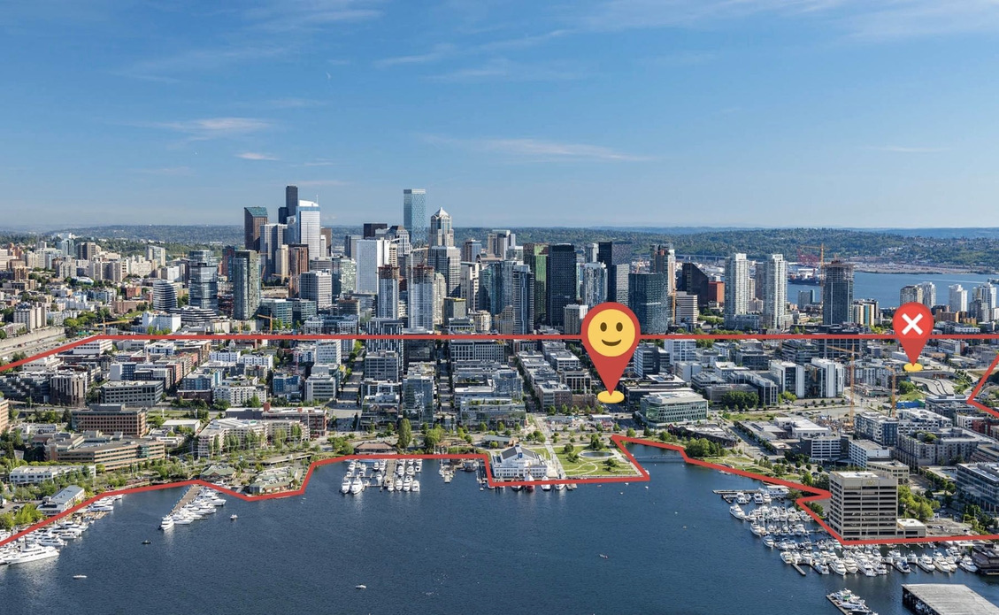
A station under Westlake located approximately between Harrison and Republican has a lot of advantages. Though it’s still slightly to the west of the center of South Lake Union, the walkshed includes nearly all of this dense neighborhood. It’s aligned with the Denny station which means isolated construction impacts and the potential for a shallow station. It can also cross SR 99 further north where it isn’t as deep while avoiding the need for a complex and expensive mined station under the highway.
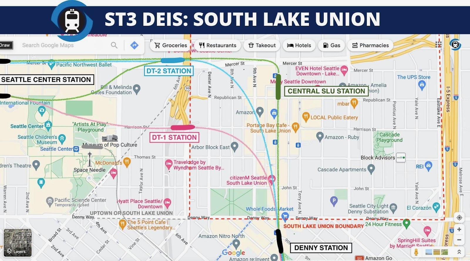
A SLU station under Westlake aligned north/south can also serve the dense population and job centers to the north and east far better than the proposed DEIS SLU station locations. Aligning the station north/south will also enable a future Link extension along the highway 99 corridor much easier – opening up one of the best corridors for transit oriented development opportunities in the country.
We were initially enamored by the SLU Harrison station due to the potential for bus to train transfers but the depth, location relative to SLU, and awkward pedestrian environment has convinced us a different option is needed. Sound Transit is looking for cost saving measures to help them deliver ST3. This is an opportunity to build the SLU station both cheaper and better. A true win/win.
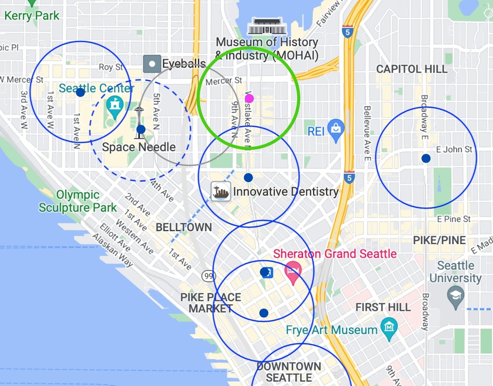
Though a Westlake aligned station for SLU is close to the Denny Station, it’s far from the closest stop spacing in the system and is entirely appropriate urban stop spacing for a very dense part of the city. A Westlake station also means a far better combined quarter mile walkshed than Harrison or Mercer stations – which are both marred by their proximity to wide roads and a highway. If you consider the walkshed of the Monorail (which is adding capacity), moving the station to Westlake does almost nothing but gain critical high value walkshed coverage.
Ask Sound Transit to study a shallow central SLU station.
We will have our complete EIS recommendations available soon, but if you are commenting now please include asking Sound Transit to study a Westlake Station that really serves SLU.
A Westlake SLU Station makes so much sense… the other two options aren’t even inside the SLU boundary line.
Westlake serves Fred Hutch’s campus, East SLU (very dense residential), the waterfront, and Dexter corridor very well. The other two options either force you to walk 3 blocks and cross a 6-lane Dexter Ave to reach the station OR force you to walk 5 blocks and cross both 6-lane Mercer and 6-lane Dexter. That’s terrible for people’s experience and a major ridership deterrent.
Sure there will be transit disruption, but the SLU Streetcar will already be disrupted anyways at Denny (and CID) and they could still run a single car on Terry Ave. Buses can always be rerouted.
The long term game is building a station that legit serves this neighborhood excellently for centuries thereafter. That’s worth a few years of temporary disruption.
Westlake all the way.
Speak of disruption, this alignment would allow for far more cut & cover of the alignment, not just the station, which would be an immense cost saver.
If they are afraid of disruption, then the station could be moved a block east, to Terry. That would be similar to how ST built the U-District station using Brooklyn, not The Ave (AKA University Way). Closing Brooklyn was a minor disruption; closing The Ave would have been a major ordeal. Using Terry means sticking with deep bore for much of it, but the station itself would be fairly easy.
Another option would be Boren. This gets to what “C” mentioned below. The Denny Station isn’t that good either. It should be moved to the east. I think it may be possible to go north on Westlake, then turn on Lenora, then go north on Boren. I know it would be possible if the train is deep enough, but I’m thinking of staying relatively close to the surface. The train would go under the little triangle next to Cornish (https://goo.gl/maps/WbZtjvmngySt96y67), then go straight on Boren. You would have a station on Virginia (before the curve). This would put you very close to the residential towers to the northeast (https://goo.gl/maps/oYsW4mD4BRCQtMnV8) and northwest (https://goo.gl/maps/17rqg1RW6Zw5xNzW7). The South Lake Union Station would then be on Republican and Boren — offering many of the same advantages as a station a couple blocks to the west.
To be clear, the plans outlined here are just about as good. The main thing is to put the South Lake Union station in South Lake Union. Using Westlake, Terry or Boren are all a huge improvement for riders, but the latter may be easier to build.
I agree, using a street ‘next’ to the arterial can be a great option, allowing for long term street closures while minimally impacting station access. Probably depends on the foundations/parking garages underneath? In the U District there was really only that one highrise, but in Denny Triangle there is a ton of deep foundations, so the tunnel (even if bored) may need to follow a street ROW or otherwise would be very deep. Though I suppose it could zig-zag, like how East Link marks a hard left and then two hard rights between East Main and Bellevue TCs to allow it to be a very shallow tunnel.
OTOH, 9th is available to reroute the buses, and there is great value of allowing for a strong bus transfer (for example, a Fremont to Columbia City trip). Even with a double transfer plenty, that may be far enough north that rider trying to transfer to East Link or Sounder from the 40 may prefer switching to Link to pass through downtown?
for example, a Fremont to Columbia City trip
Good point. Moving the station east would make the transfers from the Aurora corridor (5, 28, E) worse, but it would make the transfer from the 40 better. The loss from a bus to rail standpoint is thus even smaller. The gain for walk-up riders more than makes up for this loss.
I think that moving station platforms is a complicated topic. I’m glad that Seattle Subway is thinking about depth as it’s the layout of the station and station depth that affects its usefulness for both transferring riders and walking riders. Topography and construction difficulty are details that have to be assessed.
I have often thought that ST should have added more than two alternatives for station locations here. Sliding the positioning of each platform on a given TBM path and adjusting the TBM path creates more than two ways to build this station.
To that end, the treatment of crossing that noisy car river called Mercer Street is to me also an important issue. It often can take a two to three minute wait just to cross the street when the walk sign finally changes. It’s a stressful experience even with a crosswalk signal. The City needs to have a companion plan on pedestrian circulation in this area generally and particular in how to cross Mercer.
So how would station entrances and mezzanine circulation work here?
To that end, the treatment of crossing that noisy car river called Mercer Street is to me also an important issue.
It is an important issue. Not only that, but you also have a hard limit to the north — the lake itself. It is tempting to move the station a block south, to Harrison. You would gain more to the south than you lose to north. That is what I would do if this was the only station in the area.
But it isn’t. The Denny Station overlaps this station, so Denny and Westlake makes the most sense. Hopefully SDOT improves this crossing over time (justified for reasons other than just transit).
Building a ped tunnel from the platforms to Mercer (both north and south sides, ideally) would help greatly in this regard. If it is a shallow tunnel, it could help with crossing Mercer irrespective of trying to ride Link.
I’m not too worried about it being close to the lake, as the lake is a destination in and of itself, a major amenity for the neighborhood.
The lake is a relatively small destination compared to the concentration of people in the other direction. This is always an issue with waterfront stops. You gain some people because some beaches are popular, but you typically lose more because there is only so much land that direction. A map showing walking distance gets flattened to the north — there is nothing else there.
The parkland near the water, as well as the beach is not that busy most of the time. At best it become like the Stadium Station — really busy on rare occasions, but the lowest performing station in our entire system, because on a day to day basis there just aren’t that many people going there. I would guess that a lot of the people walking around there are locals.
To be clear, that area is still better than the area next to the proposed station (which has two city blocks of absolutely nothing). It is just that the area south of Mercer and east of Aurora is full of people, and you want the station to serve as many of those people as possible.
“The Mercer option is slightly less deep at about 85’ but its location west of highway 99 isn’t really in SLU…”
Indeed. I know the current trend is to brand anything within a mile of the south end of Lake Union as “SLU” – including sites halfway up Westlake, Dexter, or Fairview, or south of Denny – but anything west of SR-99 is more ‘Seattle Center’ walkshed than SLU.
Is there any issue with how sharp of a turn a subway is allowed to make? Because that Westlake station, while being 1000% times better than the proposed alternatives, seems to require a 90 degree sudden turn to go up Mercer.
The downtown tunnel makes a very sharp turn from Third to Pine. Based on what I can tell the tunnel does, this would not be as sharp. Mercer is extremely wide, which means you wouldn’t have to go under the buildings. It is also possible that it would be no big deal if you went under the buildings. My guess is these buildings are not that deep (since they aren’t that tall).
Right angle turns aren’t ideal but they are common in subways. NYC’s trunk lines have two near midtown and Seattle has close to one at between University and Westlake. They key is that they are close to stations where the trains are already slowing down.
That said, if a wider turn and a different crossing point than Mercer is possible, great! Seems like that should be possible but we’ll leave those details to engineers (who can also adjust the exact station location if needed.
The minimum curve radius for a Siemens S70 variant is 82 feet, but obviously that requires speeds below 71 mph.
https://assets.new.siemens.com/siemens/assets/api/uuid:9a185a1e0da027446d67bb4b07876b6477aeec62/version:1527245444/portland-s70-data-sheet.pdf
That means it could make that turn easily, even with two tracks side by side.
The trains S70 has a max speed of 55 MPH, so that 71 MPH cap is no issue
The maximum service speed is 71 mph, as listed in the data sheet provided. TriMet limits them to 55 mph in its service, which is the example data sheet given.
It means more travel time which could negate the time savings offered by the train.
Considering that it’s right next to a station platform, I imagine the actual travel time time penalty for that curve is pretty low. Not nothing, but much less than the time to ride an escalator to a deep-mind platform, I would guess.
I wonder what the Gates Foundation wants. Seattle is a place where stakeholders have agendas and preferences which aren’t apparent to the public, and these stakeholders know how to make their case to targeted officials without the public ever knowing.
Yeah, it’s hard to say. There are a lot of big stakeholders in the area so we doubt a single one (or group) gets to be the only vote that matters.
That said, there are ways to tweak options to make the maximum number of stakeholders happy – we’re all ears. Maybe stakeholders would prefer the line swing out and cross 99 further north. That seems doable but we’re not engineers. We think this option is worth a more detailed look though.
They want to keep their views of the lake
Speaking of stakeholders, a station at Westlake between Harrison and Republican would conveniently be one block from Amazon Corporate Headquarters.
Another thing to consider would be a Denny station at Fairview instead of Westlake. Could cut and cover north of new Westlake down Virginia with a station at or north of Denny on Fairview. Would then continue down Fairview and turn west along Mercer – the biggest challenge here would be curve radius. This would allow for an E/W station along Mercer at Westlake, which could allow for entrances at either side of Mercer. Seattle Subway could still work towards getting the station designed for a future line north branching off after the Mercer/Westlake Station.
I’ve been begging for the Denny station to be at Fairview instead of Westlake for years. I think combining a Fairview station with a Westlake/Dexter station would be great. Losing good connections to Aurora buses is really sad, but unfortunately it’s clear at this point there’s no way to fix that.
That said, I doubt any non-station construction will be feasible with cut-and-cover due to the necessary depth of the Westlake station and underpassing the 99 tunnel, as well as the fact that Fairview/Denny is at the top of a hill.
The premise of this piece is correct, that the SR 99 “SLU” station is horribly located at the gaping entrance to the SR 99 tunnel, a pedestrian-hostile location surrounded by vent shafts and fast turning traffic, a long walk from most destinations, and it should move to SLU proper. The Gates Foundation is a quiet suburban campus that does not merit its own urban rail station. It’s a glass fortress with zero relationship to the street.
Two subway stations four short blocks apart in SLU is too close. Denny/Fairview, or better yet, Denny/Minor even further east, best captures the Denny Triangle walkshed while avoiding overlap with the SLU station. Has anyone noticed there’s a raft of new 40 story buildings over there? I would look at drilling under Virginia St. (a straight shot from Westlake) and targeting a station at Denny/Minor before taking a wide sweep to the next logical station, near Westlake/Republican as this piece advocates. Forget SR 99 bus integration; that’s a tertiary concern because those buses go to the same places downtown.
The real question is, what is it going, to take, politically and structurally, to turn this project into one that actually works (and is affordable). It’s going to require leadership. DEIS comments (still worth making) are not going to do it because this project is too far off track. I won’t shed a tear if West Seattle Link never happens, because that project makes no sense as a transit project. The SLU/Ballard line is so obviously badly laid out I’m at the point where it needs a complete reset. And the transfers downtown are so painfully and permanently inefficient, I am almost sorry I voted for ST3.
I don’t mean to be a grouch. This project is set up to fail. It desperately needs a reset. The emperor is quite scantily clad.
I support this! All things considered, this station proposal seems to be superior.
For the common person this idea makes great sense. I have lived on lower Queen Anne and west of 99 is a terrible pedestrian experience. Of course the heart of SLU is west of 99 (and as noted west of Westlake). As Ross notes crossing Mercer on foot is not ideal, but it is better than walking from Harrison or west of 99 along Mercer. I highly doubt the stakeholders along this area would go for restricting car capacity on Mercer since it is already poor, and the city spent a fortune on improving it. My guess is the Kraken would object to restricting car capacity from I-5 to Climate Pledge Arena. (Ideally the entrances and exits on I-5 in this area would be redone to avoid the need to cross traffic to get to and from 5200.
I have to think ST’s proposed station locations are based on some kind of stakeholder input because they don’t make intuitive sense. There are some very large and powerful employers in this area, and I am not sure what kind of construction impact a “shallow” station at Westlake would cause, and for how long. Let’s not forget most of these employers are building offices on the eastside, and allowing their employees to choose where to work, or to work from home. With the current state of downtown Seattle a multi-year construction cluster F at this location could result in more employers and employees heading east, unlikely to ever return.
I also don’t know where the line continues when SS writes, ” It can also cross SR 99 further north where it isn’t as deep while avoiding the need for a complex and expensive mined station under the highway.” Is this true, and what does that do to the rest of the routing (although personally I don’t see the funding to run light rail to West Seattle and Ballard, certainly underground, and WSBLE has always meant “SLUE” to me, the one critical urban extension in WSBLE).
If this plan came to fruition I think the eastside subarea would demand its trains continue to SLU in a one seat ride. Virtually no one on the eastside will take light rail to Ballard, West Seattle, Roosevelt or Northgate let alone Everett or Tacoma (why would they), but they do need to get to SLU to avoid three or four transfers, or a pretty brutal commute by car (at least pre-pandemic). Those going to the UW are younger students and more likely to accept a transfer from the eastside, and will likely be those students who live south of I-90 or close and so don’t take a one seat bus across 520 to UW.
I guess I would like to see why ST chose the stations it did. SS is correct that on their face they don’t make much sense, but of course none of WSBLE does until you understand what the stakeholders are demanding: they don’t want to see, smell or hear light rail, which means deep underground.
Before we complain to ST about deep stations with inferior walk sheds, we need to get them to publish their first principals for transit riders. These principals should cover station depth, transfer penalties within the same mode as well as to other modes, and other factors that impact rider experience.
If these principals don’t exist we (Seattle Subway) should create them and force ST to adopt them. To get action on this we can start with primary challenges to all elected board members, and take our principals into community engagement meetings to communicate our expectation that we didn’t give ST $15B to bury a train where no one wants to ride it.
THIS IS EXACTLY WHAT I WAS THINKING.
There needs to be a plan of action to get ST to “De-crappify” WSBLE.
None of the DSTT2 stations should be more than 50 feet deep.
If stuff has to be moved, then move it. And not on ST’s dime.
“THIS IS EXACTLY WHAT I WAS THINKING.
“There needs to be a plan of action to get ST to “De-crappify” WSBLE.
“None of the DSTT2 stations should be more than 50 feet deep.
“If stuff has to be moved, then move it. And not on ST’s dime.”
That is not how it works FDW, and I think SS understands that. You build a multi-billion dollar subway (or surface line) to serve the existing needs, which are jobs, commuters, retail and restaurant vibrancy, and whatever reasons there are to come downtown. You don’t destroy the bases for light rail in order to build it. Light rail has no value or benefit in itself, which is why you don’t build it in rural areas.
The people who own the things downtown you want moved — apparently on their dime — are not STB bloggers (and don’t ride transit). We are talking skyscrapers, sewer mains, water mains, utility lines, small and large businesses, you name it. They have big money with lots of lawyers, and right now Harrell is desperate to keep them and their employees downtown, or to at least attract them back. Otherwise there is no point to light rail.
The reality is you can’t de-crappify WSBLE, which was just a made up rail line to sell ST 3, just like you can’t de-crappify Issaquah to S. Kirkland, because none of the bases for light rail and the huge costs of light rail exist for either because it is at best suburban rail, across or under water.
It is the classic error of building mode — light rail — despite the cost or ridership or benefit, thinking light rail has some inherent value in itself, or neighborhoods like Ballard or West Seattle value light rail more than their neighborhood character (Issaquah has the land to put the stations far, far away from the core) rather than as a last resort mode when no other mode can handle the ridership anymore, which believe me won’t be a problem for WSBLE or Issaquah to S. Kirkland which could easily do with 30 minute frequencies, which is as Ross would note is the antithesis of the predicates for light rail, let alone subways.
The reality is you can’t de-crappify WSBLE, which was just a made up rail line to sell ST 3, just like you can’t de-crappify Issaquah to S. Kirkland, because none of the bases for light rail and the huge costs of light rail exist for either because it is at best suburban rail, across or under water.
You are probably right, but at least we can try. I do think that de-crappifying WSBLE is a lot more likely than doing the same for Issaquah to South Kirkland. West Seattle Link is bound to be a bad value, but it can at least serve The Junction. No, its not the right mode, and spending billions on it is ridiculous — but it shouldn’t be total crap, even thought that is quite possible at this point.
Ballard is a lot more nuanced. There are plenty of people who travel along the corridor. Done right, and it would be a decent value. Done wrong, and it will be crap. At this point, it is heading straight to crapville. Terrible transfers is the first, and possibly fatal flaw. As a stand-alone line, Ballard Link wouldn’t get that many riders — it is highly dependent on train-to-train transfers. Deep stations are a deep cut. Poor station placement (e. g. the subject of this post) are worse. All of these flaws build on each other. Throw in poor frequencies (which feed off of all of these flaws) and a gradually improving bus system, and the whole thing becomes irrelevant, even to the type of riders who normally flock to mass transit system.
I remember d. p. once gave me this example. Imagine you are trying to get from Westlake and Harrison to 12th and Harrison. This is a trip within the urban core — some would even say “downtown”. This is a land where people routinely don’t own cars, or only break them out for special occasions (like a trip to the seashore, or the mountains).
Now consider the trip, using this new, multi-billion dollar mass transit system. Unlike First Hill or Belltown (also parts of downtown) the train purportedly serves these neighborhoods. But does it, really? You start with a walk of somewhere between 5 and 7 minutes, just to get to the entrance. Then it may take you another another 5 minutes to get to the platform. Your train runs every ten minutes (unless ST has a sudden epiphany, realizing that running trains more often is more important than serving places like Fife). This is followed by a short train ride, and then a walk from platform to platform taking another 3 to 5 minutes (assuming the escalator isn’t broken). Finally you get to the platform where you can take the train to Capitol Hill. All this, just to go one mile.
You are better off taking the 8 of old, let alone the 8 of the future. No, it won’t be especially fast, but it will be direct. It may not be as frequent, but it will likely be in the same ballpark (prior to the pandemic the 8 ran every 12 minutes). Most of all, it won’t involve long extra walks to the platform from the surface, as well as from the other platform.
It is around this point in the argument where someone says something along the lines of “But Ross, that is a short trip — mass transit isn’t supposed to be about that”, and I, of course, say “Hogwash”. Mass transit thrives on these sorts of trips. All around the world you can find short mass transit trips carrying huge numbers of people. Even BART, clearly designed for long distance trips, thrives on short distance trips. The majority of trips are within the urban core (only 9 stations). It is striking, really, and encourage anyone who disagrees with this idea to just look at the stop data, which you can download here: https://www.bart.gov/about/reports/ridership. This is real stop-to-stop data, unlike what ST provides. You can see that thousands upon thousands of people travel a mile or two within the urban core, just as they take Muni a short distance (despite all of its operating flaws). These are the trips that keep BART from falling into oblivion, and sinking like similar systems like those in Denver or Dallas.
If we fail with this part of the system — and it looks like we will — we will have blown one of our few chances to keep this mess afloat. This new line won’t get anywhere near the ridership that was suggested, and the transit modal share for the region — once the envy of the rest of the country — will be stagnant, while Metro continues to beg for more money (knowing full well they would put it to much better use).
In short, our transit system will be crap, and local will look at cities like Vancouver and wonder why we didn’t build something like that.
“If this plan came to fruition I think the eastside subarea would demand its trains continue to SLU in a one seat ride. Virtually no one on the eastside will take light rail to Ballard, West Seattle, Roosevelt or Northgate let alone Everett or Tacoma (why would they), but they do need to get to SLU to avoid three or four transfers, or a pretty brutal commute by car (at least pre-pandemic)”
I don’t understand. In previous posts my understanding of your position is that even if the impossible-to-build-tunnel-because-there-isn’t-enough-money is built, that hardly anyone will be taking LINK from the eastside because of WFH and the love of driving the car.
And now we are supposed to think that the entire eastside will see such an advantage to a line directly to South Lake Union that they will queue up in such numbers during the commute (Commuters only, because surely no one will ride Eastlink during the day, why would they?) that ST will have no choice but to change its entire operational plan.
mhm… sure.
JAS, I still agree with those who think ridership on East Link will be about 50% of ST’s pre-pandemic estimates, maybe less cross lake, especially after the eastside transit restructure. Transit ridership-pre and post pandemic on the eastside during non-peak times has always been anemic. It isn’t the eastside that needs SLU, it is SLU — and transit — that needs those eastside commuters (who tend to have a 100% fare paying percentage). That is why East Link runs along 112th.
I think the rerouting of the 554 to a one seat ride from Issaquah’s park and rides to Bellevue Way indicates eastside commuters to SLU will decline pretty steeply post pandemic. At least Metro thinks so, and Bellevue hopes so. The 630 suggests these commuters — if any — will not willingly transfer more than once, if that. I still stand by my original statement that if the eastside commuter from Issaquah to Seattle returns post pandemic they will demand a one seat express bus, certainly if a transfer from Link is necessary to get to SLU, like Lake City got.
Since the eastside subarea is paying 100% of East Link (plus around $2 billion in subsidies to N. King Co.) and East Link trains will increase frequency in the downtown core to around 3 minutes while East Link is limited to 8-minute frequencies, yes, I think the eastside will argue that if in fact anyone from the eastside will actually take light rail cross lake to Seattle it will be to SLU so make that a one seat ride. I highly doubt many on the eastside will take transit to Ballard or West Seattle or Northgate, because why would they?
I hope there is sufficient revenue for this one leg to SLU in the WSBLE budget because I have always thought this is the missing leg (along with First Hill). Kind of foolish for Seattle to upzone this area so heavily without light rail access. Do I think there is revenue to run a 120′ deep tunnel under downtown Seattle and to West Seattle and Ballard? Of course not, and neither does ST or the preferred alternative would not require “third party funding”.
East King Co. has too much ST revenue just from ST 2, let alone ST 3. I imagine EKC would not object to contributing to an extension to SLU as part of its obligation under ST 3 for DSTT2, although I am not sure how many eastsiders will use it. But to get that contribution ST and N. King Co. will probably want to run East Link trains to SLU.
I think the reality is those riders will either WFH or switch to their employer’s downtown Bellevue offices to shorten their commute, have a one seat commute, and to be in Bellevue and not SLU which is kind of dead retail wise. But if hope springs eternal and ST can build any part of WSBLE, and someone on the eastside wants to commute by transit to SLU, and Seattle and ST desperately need those eastside commuters and they have all the money why not run their own East Lake trains to the places they might want to go: downtown Seattle and SLU, although that will likely require revitalizing both, and at this point that may be impossible.
Remember, transit including light rail follows ridership. Right now I don’t see the ridership for any of WSBLE, and would wait on the DEIS if I were ST, except I think future data would doom WSBLE. But if there is one leg that might make sense even with the condition of downtown Seattle and the changes due to the pandemic it is Westlake to SLU. Period. And no, eastsiders will not “queue up in such numbers during the commute (Commuters only, because surely no one will ride Eastlink during the day, why would they?) that ST will have no choice but to change its entire operational plan.” That is the dream, Jas.
The reroute of the 554 indicates that after spending several billion dollars on a light rail line, nobody wants to duplicate the same service the light rail line performs with buses running parallel to it.
This is what happens when rail transit gets built. Eliminating bus routes now served by rail means you can do things with the buses you couldn’t previously.
When MAX red line was built, bus route 12 no longer needed to go to the airport, so instead it goes east to Parkrose, which previously lacked direct Portland service.
When the orange line got built, all the hours that used to go into sending 13 buses per hour into downtown got redeployed into things that previously could not be afforded. Two different bus routes now serve Clackamas to Oregon City routes with greater span of service and better coverage. King Road and Highway 99 is now a 1 seat ride, while before the King Road bus was only every half hour, at best. Route 34 extended to the Precision Castparts factory on Johnson Creek Blvd, an area that hadn’t had transit since the interurban left in 1958. Route 99 now connects southwest Portland to the highway 99 corridor, a service that has never existed.
So of course people will use the new 554. Providing better trip combinations is why these projects are being built. It’s nothing about betting against South Lake Union.
Glenn’s remark about Route 554 is solid; it should not duplicate Link to provide translake trips. It alignment will probably be a powerful intra Eastside trunk line, if ST is smart enough to provide short headway and waits. But why does Route 566 continue to duplicate Link between BTC and RTS; why does Route 545 continue to duplicate Link between the UW and Westlake stations; why does Metro propose to duplicate Link with routes 630 and the conceptual Route 256?
“why does Route 545 continue to duplicate Link between the UW and Westlake stations”
It was a very high ridership corridor before covid, with buses every 5 minutes packed full until 10:30am. So it’s harder to split than the 255 was. And covid and its ridership plummet threw everything into uncertainty, and it’s only for two more years anyway.
Eddie asks, “Why does Route 566 continue to duplicate Link between BTC and RTS?” Can someone tell me what he’s talking about?
The post East Link route of the 554 between Issaquah and Bellevue Way is important because:
1. East Link does not serve Bellevue Way, which is the heart of Bellevue. Transit cannot create a Bellevue Way, especially the retail vibrancy, only serve it. This is the entire point of locating the SLU station in SLU. Amazon and the rest are not going to go to a Link station on the west side of 99. Link needs to come to them. It also reflects what happens when ST demands a city or neighborhood accept a design (surface or elevated) it does not want. Otherwise, West Seattle and Ballard will move a surface station/line to the equivalent of 112th.
2. The 554 does mimic East Link from the S. Bellevue park and ride to Bellevue (although not to Bellevue Way). That is because work commuters don’t want to transfer, especially so close to their ultimate destination. If Metro attempted to force the commuters from Issaquah to transfer to East Link at S. Bellevue station (after driving to a park and ride to catch the 554) they know those riders would just drive to the S. Bellevue park and ride, which would make the large park and rides in Issaquah superfluous and create a lot of congestion at S. Bellevue, which will be a zoo anyway. This is why East Link should be a one seat ride (on East Link trains paid for by the eastside subarea) to a SLU station that is right in SLU.
3. The route of the 554 post East Link was switched from truncating on Mercer Island to truncating at S. Bellevue to finally accessing Bellevue Way, because Metro/Bellevue/Issaquah determined these riders will (or should) be going mostly to Bellevue and not Seattle post pandemic (or WFH, or more likely a combination), and they don’t want to transfer. The one seat ride is more important than mode to them.
4. Until a Link station opens at SLU, and there is a one seat ride on East Link to that station, commuters from the Issaquah and eastside areas going to work in SLU (and who tend to be high value) will demand a one seat bus, like the 630 or the buses from Lake City. The transit slave days are over. Seattle and SLU desperately need these eastside work commuters who pay 100% of their transit fares and generate huge tax revenue to continue to commute to downtown Seattle and SLU. Clean up Seattle, return the retail and restaurant vibrancy, and have a one seat ride on East Link through downtown to SLU, and you just may attract them back despite the extra distance, although we are talking a decade away, and it will be difficult to reverse the jobs migration east after a decade.
The ultimate point so many transit advocates don’t get is mode has very little to do with anything, certainly for work commuters. First there has to be a place people want to go to, or have to go to, in such numbers driving is difficult. Second they want easy first/last mile access, while at the same time wanting a one seat ride. That is defined on the eastside as a park and ride. Some anti-car urbanists may not like that, but these workers are highly coveted, can now WFH, and most major employers like Amazon are offering them the option to work at any office. So time for Seattle and ST to realize they need to compete for these workers, rather than treat them like slaves.
They no longer need Seattle, and they no longer need transit. Their decision where to work and how to get there, if at all with WFH, is purely discretionary, and right now ST and Seattle are not offering a competitive option to the eastside, Bellevue, and even buses.
“Eddie asks, “Why does Route 566 continue to duplicate Link between BTC and RTS?” Can someone tell me what he’s talking about?”
It took me a while to figure it out. The 566 is the Auburn-Kent-Renton-Bellevue-Redmond express. So assuming RTS means Redmond not Renton, the question is, why isn’t it truncated at Bellevue and people transfer to East Link? I wondered that too in the proposals, because the distance is long enough that a transfer is appropriate. Possible reasons:
– Deference to one-seat riders.
– The train-bus transfer distance at Bellevue TC is so long.
Never mind that the train-bus transfer distance also hinders transfers to the B, Stride, and someday RapidRide K. We tried to warn ST about that, and get a station in the Bellevue tunnel that would have been closer to the bus bays.
Sam: ST Route 566 connects Kent and Overlake via Renton and Bellevue; between BTC and RTS, it will duplicate Link. To minimize the duplication of Link, Route 566 could be truncated at BTC. Link will have ample capacity between BTC and RTS. https://www.soundtransit.org/ride-with-us/routes-schedules/566?direction=0&at=1649401200000&view=table&route_tab=schedule&stops_0=1_71339%2C1_57776&stops_1=1_57774%2C1_71336
The 566 could terminate at S Bellevue P&R. Mighty fine bus to train transfer there and it avoids at least part of the 405 congestion. It’s also a win for those coming from Kent/Renton and headed to Seattle or Issaquah (which is turning into a decent size jobs center).
Ok, thanks. I get it now. RTS = Redmond Technology Station. Yeah, that seems like a good idea. I don’t see why they wouldn’t cut off that portion eventually.
South Bellevue will be hard to get to from the center HOT lanes; I would imagine all the express routes go to BTC with the center exit lane, not S Bellevue
With respect to the 545, I think the strongest argument for the duplication is to provide an alternative for those days when the 542 is unable to travel between a Link station and the freeway without a long delay.
Example situations where the 545 offers a sizable time advantage include Husky football games, ramp closures due to ongoing construction at the 520/Montlake interchange, closures of the Montlake bridge due to ongoing maintenance, plus occasional other events at Husky stadium. For instance, I once had a 255 get delayed by about 15 minutes at 9 AM on a Saturday morning, due to a 5k run. The 545 also has a shorter detour than the 542 when the 520 bridge is closed and buses are rerouted to I-90. Each of the above situations don’t happen all that often individually, but taken together, they do add up. On top of this, COVID has kept enough office workers at home that congestion down the Stewart St. exit ramp is far less than it used to be.
I still think it’s important that Bellevue, Redmond, and Kirkland have buses to the U-district – all bus travel across Lake Washington should not be required to go through downtown, as it’s out of the way for many trips and forces riders to wait at less than ideal bus stops, such as 3rd and Pine. But, having some bus do Redmond->downtown, at least until the 520 construction is finished, seems like a reasonable compromise.
Once the 520 construction is finished around Montlake, a lot of the arguments for a bypass route that goes straight down 520/I-5 to downtown go away. There will be an HOV exit ramp with bus lanes on Montlake until Shelby St., which should keep buses mostly out of traffic. Even under worst-case traffic conditions, passengers could get off the bus at either Shelby for the 520 lid and walk to UW station. Not ideal for every day, but acceptable when necessary. East Link opening up around the same time will also help.
Another reason the 566 isn’t modified may be that it wasn’t in the list of routes considered for restructure. South King is paying for it and can say where it goes. It may be waiting for the Federal Way Link restructure, which I’d expect to start this year or next year.
I wouldn’t truncate the 566 at South Bellevue. That seems like a too-pendatic “stop just short of a major center”. That would be like the 11 terminating at Broadway and expecting people to transfer to Link for one short mile to downtown. ST Express should go between major centers, not just short of one on one end. This also gives a reason for the 554 to continue to downtown Bellevue, because otherwise it would be in the same position. The 554 shouldn’t be just a transfer-to-Seattle route when it can also be a go-to-Bellevue route with just a short extension.
Once again, I agree with Seattle Subway. This would be a huge improvement, even if it was at the same elevation. The ability to move it closer to the surface would be a bonus.
It is worth noting that ST wanted to put the station close to Aurora to improve the bus transfers. This is a laudable goal. I am a strong believer in the importance of bus to rail transfers in our system. But in this case, you lose too much, and gain too little.
The two proposed stations are both very poor from a walk-up standpoint. Much of the walkshed is used up by the Aurora interchange as well as Mercer. Even the Gates Foundation office park is low density compared to everything to the east.
But you also don’t gain that much from a bus-to-rail transfer standpoint. Riders headed downtown will simply stay on the bus. Riders heading to Capitol Hill will stay on the bus, and transfer later (or transfer to the 8). Riders heading to the UW or Ballard will get off earlier, and catch the 44 (as slow as it is). That basically leaves transfers to Uptown, Interbay, Rainier Valley and places south. There are a significant number of riders doing this, but not a lot. These riders can still make the transfer; they will simply make it further south (at Westlake or University Street). The transfer station — especially one very deep — will not save that many people that much time.
In contrast, moving the station east would save a lot of walk-up riders a lot of time. Ridership of this station would increase significantly as a result.
Why a quarter mile walkshed? That’s what you use for bus stops, but rapid transit is more like half a mile. Back before the pandemic plenty of people were walking from Mercer down to the 8.
I’m not sure that a station between Seattle Center and Denny is needed at all, and if it should be built somewhere I think it would be better to jumpstart growth west of 99, not east of it.
The quarter mile rule is just a guideline. Some people will walk farther, some shorter. For this reason, what you really want is a heat map, with the shorter distance being darker, and fading out as you go. If your destination is a block or two from the subway stop, most people don’t hesitate using it. But if it requires a ten minute walk (followed by another five minutes down to the platform) most will say the hell with it, and call a cab (or take a bus). In between is where you have a mix. Remember, the whole point of this multi-billion dollar mass transit system is to save people time. If they are spending it all getting to the platform, they haven’t saved a second.
You also want real walking distance maps, which resemble diamonds, not circles. But the circles are a very good summary of the issues involved. You can imagine them being a bit bigger if that makes you happy, while I can imagine them being diamonds instead of circles. Whatever. The point is, this is a much better station if your goal is ridership, or saving your potential riders the most time.
I’m not sure that a station between Seattle Center and Denny is needed at all, and if it should be built somewhere I think it would be better to jumpstart growth west of 99, not east of it.
Wait, what? Do you think we are building an expensive mass transit system to spur growth? Why the hell would we do that, given that growth is happening anyway, regardless of mass transit. Oh, and where is this growth supposed to happen — inside the Seattle Center? Come on man. The whole point of a mass transit system is to save people time — to actually serve them. You know, the greatest good for the greatest number, and all that. This station does that. A station next to the Aurora interchange (two square blocks of absolute nothingness) does not.
Time is a much better metric than distance. Especially when distance is a circle rather than actual walk path. Several years ago Bellevue revised it’s school bus coverage based on actual walk distance (and safety) to include many households that were previously considered walking distance to school. It really didn’t cost anything since when you get within a mile of a school the convergance of bus routes means very little diversion and no new routes. In DT if there’s multiple high frequency bus service that expands the “walk shed” because it’s essentially a moving sidewalk.
Time is a much better metric than distance. Especially when distance is a circle rather than actual walk path.
I agree, but in this case, they are pretty closely synonymous. If anything, the case for moving this station is helped when you consider the actual walk time versus distance. Crossing Mercer takes a while. In some cases, you have to go out of your way to get there (https://goo.gl/maps/mAt7taEwYydodagF8). To the east, on the other hand, it is very straightforward — there aren’t any obstacles until you get to I-5. You can see this on a map — you can also play around with Google Maps, or a tool that draws boundaries based on walking travel times. What you’ll notice is that a walk from Westlake and Republican is a near perfect diamond, whereas anytime you get close to Aurora things look rather strange.
In other words, you can draw circles using distance, or diamonds using walk time, and you still get the same results: the proposed station(s) next to Aurora are crap, and this station would be much better.
I present this example of how walkshed is impacted not only by distance, but also busy streets.
My closest MAX station is SE Foster Road. West of the freeway interchange, the past 10 years has made the area look like this:
https://goo.gl/maps/NyZEQYffg6Z8q8ox5
On the east side of the freeway, where people have to cross the freeway interchange to get to the MAX station, it still looks like this:
https://goo.gl/maps/E56yVBpESpEC1Ah39
Glenn, are you sure that’s not just zoning? Looks like a very pleasant walk to Ellis St but there aren’t any midrise buildings there either.
I tried to pull up the zoning maps but the website wasn’t working for me.
It’s not zoning. Foster Road is zoned for the same commercial and high density residential throughout.
Not sure where Ellis came from?
A Westlake SLU station is the way to go. A central location and a convenient walk shed are the two most important criteria from a pedestrian / rider perspective. The Westlake SLU station is the clear choice based on these two criteria. Please prioritize rider needs!
Just delete the DT-1/DT-2/SLU Station, then relocate the Denny Station to somewhere around 5th and Bell. But provision the Bell Station to accommodate a future stub line towards the north which would bring future service to SLU, the east slope of QA, and Fremont.
Such a “direct” routing would save 100’s of millions of dollars, and result in a more direct and quicker route which would better serve the riders in Lower QA, Interbay, and Ballard. Track speeds could also potentially be higher, further increasing the benefit of the direct route.
Then redirect the savings to an additional station north of the currently planned terminus in Ballard. Or use the savings to complete the CCC. Or do both!
Remember, this is not the 1970’s and we aren’t designing a multi-purpose stadium. This one LR line doesn’t have to serve all potential user bases between DT and Ballard for all-time, but it should be fast, direct, and efficient. That is what LR is good at.
For all the other adjacent ridership bases that have indirect or corkscrew routings use buses. That is what buses are good at.
I’m waiting for Big Gondola to weigh in (now that it has been defeated in West Seattle) to propose something for SLU like the Metro 8 route and have Ballard to UW replace the downtown to Seattle route). [ducks]
How is the gondola defeated? Didn’t ST announce only last week that they were going to study it?
Oh. Must have been the quickest “study” ever.
https://www.king5.com/article/news/local/seattle/sound-transit-report-gondola-system-west-seattle/281-0a3111be-ac6c-46ec-ba8c-36f207a8c8b5
“”Because voters approved light rail as part of ST3, new voter approval would likely be required to change the high capacity mode for West Seattle,” said Sheldon.”
That could be a problem with switching to BRT in West Seattle. Or eliminating the second tunnel for that matter, since the West Seattle and Ballard projects in the ballot measure were predicated on it.
The SLU station should have been at Westlake/Terry and Harrison from the get go. Only a complete nincompoop would think that putting it at Gates Foundation or Aurora and calling it SLU station was sufficient.
Right now there’s no good bus service from Seattle Center to SLU since Mercer does not have buses. Putting the SLU station at Westlake and Harrison would carry a ton of traffic between Seattle Center and SLU, and not just duplicate existing bus routes. This is an incredibly valuable short hop. It allows SLU to be more accessible also by transit for people living in Magnolia and QA than currently or in the current ST3 plans. It would also reduce some of the pressure on Westlake Park. I hope someone at SoundTransit is listening or it will be a huge missed opportunity.