
I’ve enjoyed riding the East Link starter line, and one of the things I’ve enjoyed is how conveniently the at-grade stations are designed.
To get between platforms at several of the East Link stations, you don’t need to take stairs or ramps to go under or over the tracks; you just walk across the track. Sound Transit has learned from some of the problems they’ve had in the Rainier Valley, and they’ve designed these crossings very nicely:

Pictured: A crossing at Overlake Village station
The big advantage for users is, this is easy and fast to use. You don’t need to rush up and down stairs or ramps; you just open a gate and walk across the track. I’ve done this many times, and I really like it. These stations are by far the easiest for me to access.
The big advantage for Sound Transit is, this is cheap to build. They don’t need to build any of those stairs or ramps, or worry about escalators or elevators failing.
It’s a win-win.
So far, this basic design isn’t new; it’s true in the Rainier Valley stations too. Of course, they aren’t quite so easy to get to, since they’re in the middle of MLK Blvd. (BelRed station along East Link is in the middle of Spring Blvd, but that’s narrower and much less busy than MLK.) What Sound Transit’s added here along East Link is new safety measures.
As you can see in the photo above, they’ve got the typical X-shaped railroad crossing crossbucks that you’ll see when crossing a heavy rail line. When a train is coming, the lights flash and a bell rings. When trains are coming from both directions, the sign will light up saying “Another Train Coming.” None of these actually block you from crossing – you can pull open the gate at any time – but they give you a loud obvious warning.
Also, what you can’t see quite so well in the photo above is a gate that you need to open to get onto the track. I think that’s a nice measure to make you think rather than casually wandering across.
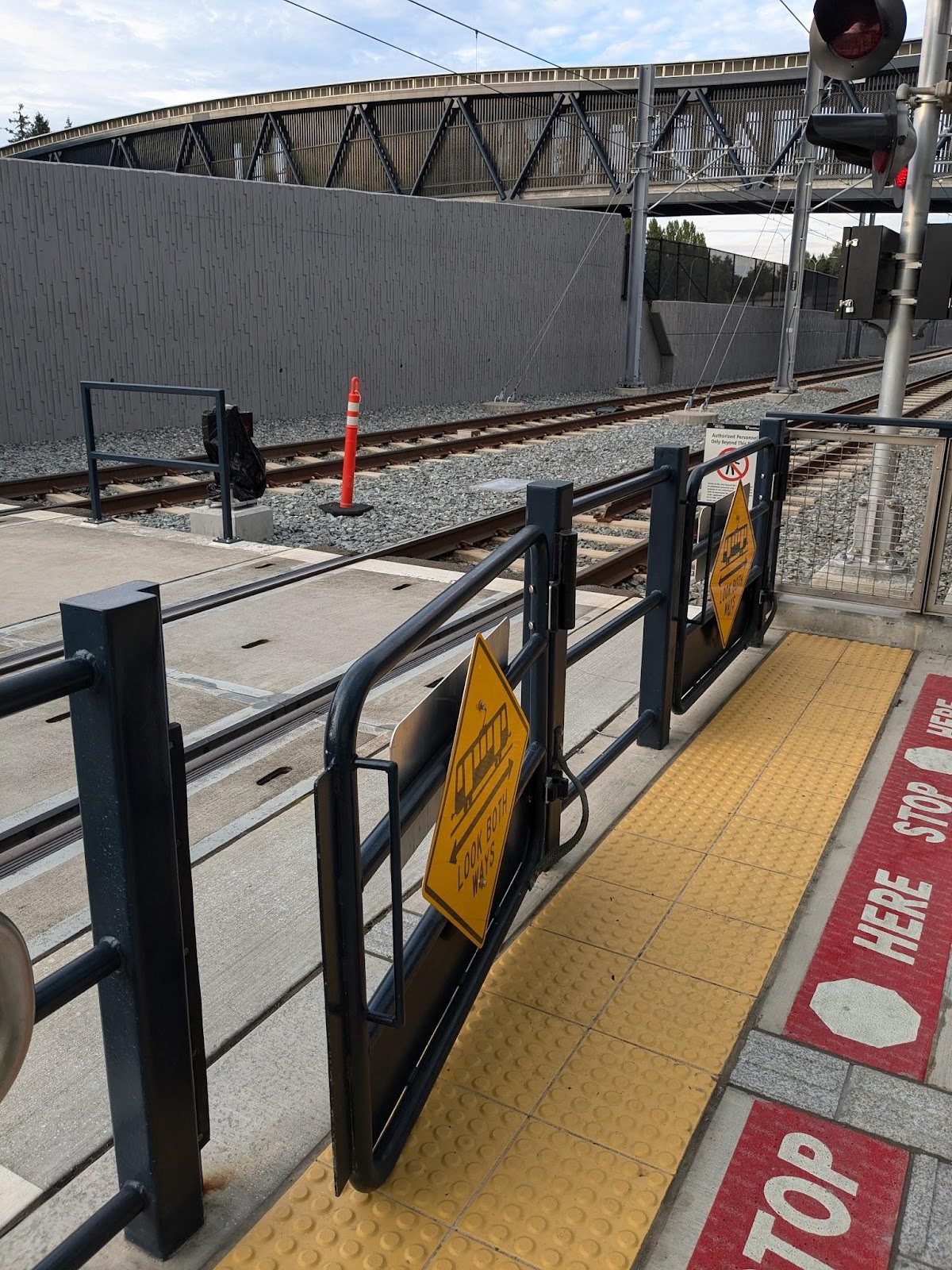
They open out from the track on both sides, so if you ignore the bell and end up in front of an oncoming train, you can just push to get out.
Unfortunately, the last time I was at Overlake Village Station, the gates didn’t quite swing closed – but they degrade gracefully. If they don’t help when they’re stuck open, at least they don’t hurt.
The one problem with these safety measures is that Sound Transit has set the warning bells and lights super-cautiously. I haven’t timed them, but it feels like they start well before a train shows up. What’s worse, the bells and lights for the crossing on the far side of the station start ringing and flashing as the train is pulling into the station, and continue all the time the train is at the station until it clears the far-side crossing.
A few times already, I’ve seen someone starting to cross the tracks after the bells start, and getting across well before the train comes. As East Link becomes more popular and more people start running to catch a train, I’m afraid this will become more common. I can hardly blame them, especially if they’re on the far side of the station trying to catch the train that’s only just pulling in.
But unfortunately, this will get people in the habit of ignoring the warning bells and lights. This will be dangerous in the future. So, I strongly advocate for Sound Transit to retime the warning bells and lights, and specifically, not have them start on the far side of the station for a train that hasn’t yet pulled in.
I’m very pleased about these at-grade pedestrian crossings in East Link stations. I hope Sound Transit is watching how well they’re working, and as they’re looking at improving safety in the Rainier Valley, I hope they take lessons from here.
Sound transit design requirements no longer permit at-grade crossings. These are the last you’ll see without the stairs, escalators and elevators to access the station. It’s a costly design requirement, but done for safety of the public.
Really short-sighted. It’s possible to have at-grade light rail done safely, at a lower price point. But the politicians of this region have been unwilling to consider it. Maybe as it becomes more clear ST can’t deliver the ST3 plan, they’ll reconsider at-grade tracks and stations where possible.
I agree. There are trade-offs but that is true of various decisions that have been made. There seems to be no consistency. We say that a station at 20th NW is too expensive to even study but then we turn around and say we can’t run on the surface (even though the crossings are minor). I’m fine with “Quality over Quantity” but if that is the goal then we wouldn’t be building most of what is in ST3.
From a safety perspective, the biggest issue with the at-grade stations in Rainier Valley isn’t the rail crossing but the crossing on MLK. To their credit, Sound Transit has tested louder bells, added more warning signs and is considering or planning on adding gates similar to ones pictured in the article. However, getting to the station is poorly designed and SDOT has been hesitant to make any improvements. Cars on MLK regularly go more than 40 mph and the lights are timed such that the cars get a green light when a train passes through an intersection. Someone across the street from the station can either watch their train arrive and depart without them, or they can risk their life to make the train. From my observations, most people do the latter. Narrowing MLK to one lane each direction and setting all lights to red when a train passes through an intersection next to a station would make the pedestrian/Link rider experience significantly safer, even if it slows down drivers by a minute or two.
Exactly. MLK is just overly wide. It results in long signal cycles, long waits to cross the street, drivers getting anxious to avoid a red light and pedestrians running against the signal to catch an approaching train. That’s a design recipe for pedestrian fatalities.
Spring Blvd /136th Place NE in Bellevue is much less dangerous. That’s because it’s not a higher speed, higher volume roadway with lots of lanes. It’s basically just a local access street and not an essential arterial.
I do disagree that reducing MLK to one lane and creating a bicycle lane would solve the problem. The street would be just as wide! The problem is the width itself — so it’s not going to get much safer by just changing the type of vehicles on the street from cars to bicycles. Everyone would still be waiting longer times to legally cross the street.
I think that a better solution for safety would be to put all the MLK traffic on one side of the tracks as a three lane street. The other side could be for bicycles, pedestrians and local access. Then the signals would not have to have such long phases.
It’s all about the long signal phases!
Pedestrian islands can be built on the ends of bike lane buffers to reduce crossing distances. There are too many driveways on both sides of MLK to fully close either side to traffic.
In terms of safety the fewer general purpose lanes the better. This is the idea behind road diets (and they work). It is still just as far to walk from one side of the street to the other, but speeds go down.
In terms of the actual lanes themselves the narrower the better. Really wide lanes encourage people to drive fast. Again, there is a lot of evidence to support that.
Thus if you did have one general purpose lane going each direction and one bike lane the road would be safer. Bike lanes — even fully protected ones — do not need as much width as regular lanes. Thus you could narrow the street as well.
@ Nathan:
There are pedestrian refuges. They’ve been there ever since Link opened. It’s where the walk to the side platforms begins.
@ Ross: At most the narrowing will be about 3-4 feet on each side. Bicyclists prefer protected lanes which take 7-10 feet. 10-11 is a typical urban arterial street lane. The best result is 2 or maybe 3 seconds off the crosswalk countdown. That’s pretty negligible in the bigger situation.
Simply put, reusing a traffic lane may be good for bicyclists — but the entire street crossing would need to be reduced by at least 15-20 feet to even begin to ease the crosswalk situation. A curb extension does very little to ease the situation.
@Al — It is quite common to take a single lane of traffic and make it a bike lane *both directions*. In this case you wouldn’t, but the result is the same thing. Assume the road lane is 12 feet wide. That means each bike lane (including the barrier) is 6 feet wide. It also means that the sidewalk (on both sides) can be moved inward 6 feet.
The road would be narrower, but the safety comes from everything else. You seem to be dismissing this, but there is plenty of evidence that road diets work. Not just for people in bikes or cars, but pedestrians as well. People drive slower when they can’t pass other cars.
What you are suggesting would require just as much space if not more. Your idea of a three-lane road on one side is number of lanes we would have for cars on the entire roadway. Either way we have room for bike lanes — you are suggesting one extra lane for local access as well. It seems like the curb to curb distance would be worse.
While the comment section is chanting “MLK road diet! MLK road diet!,” you are losing sight of the original problem. How to reduced Link-pedestrian deaths in the Rainier Valley. Let me give you a specific example. In 2017, a man was crossing the tracks at Othello, west to east, against the signal light, and was hit and killed by a northbound train. Bing it. Road diets, bike lanes, and reduced speed limits wouldn’t have helped him. So, how do we protect the people who are already in the median of MLK who are about to step in front of a moving train?
@ Sam:
Keeping on the topic of the post, the biggest problem to at-grade light rail pedestrian crossings is that people get hit. They almost always get hit when they don’t obey walk signs.
I’m just saying that it’s human nature to walk against the light — and that waiting a longer time to cross inspires a crossing pedestrian to take risks and walk against the light.
I’m also saying that the much shorter distance when crossing Link tracks on the Eastside is likely an order of magnitude safer than MLK is. I think the risk is at the appropriate level for East Link. I attribute the lowered risk to crossing at a distance of only under about 30 feet inside these stations.
Reducing a crosswalk from 110 to 100 feet has a negligible benefit for those crossing the street (the situation that you and I are concerned about here). And as you say, it’s the train that’s killing people at a much higher rate (say about 230 trains a day combining both directions) than the cars are (23,000 a day). Reducing the crosswalk from 110 to 70 feet is much safer because it reduces risky behavior because the wait is shorter. And reducing it to under 30 feet is even better!
One of the problems in the Rainier Valley is sight lines, I think.
Portland MAX, SE 17th & Holgate:
https://www.google.com/maps/@45.4914056,-122.6483862,3a,75y,186.6h,67.81t/data=!3m7!1e1!3m5!1sbdcXjcYQ4W0yzfF-UUZNyg!2e0!6shttps:%2F%2Fstreetviewpixels-pa.googleapis.com%2Fv1%2Fthumbnail%3Fcb_client%3Dmaps_sv.tactile%26w%3D900%26h%3D600%26pitch%3D22.19447164324899%26panoid%3DbdcXjcYQ4W0yzfF-UUZNyg%26yaw%3D186.6005749003032!7i16384!8i8192?coh=205410&entry=ttu&g_ep=EgoyMDI0MTAwOS4wIKXMDSoASAFQAw%3D%3D
Lots of clear sight lines for pedestrians and train operators. If the operator sees passengers close to the crossings, they operate the bell.
Othello Link station has a lot more obstacles around it that would interfere with being able to see passengers at the crossings, maybe?
https://www.google.com/maps/@47.5389279,-122.2820632,3a,75y,155.93h,83.95t/data=!3m7!1e1!3m5!1sgvtUkOM0Sgd6s4c8S8gRzg!2e0!6shttps:%2F%2Fstreetviewpixels-pa.googleapis.com%2Fv1%2Fthumbnail%3Fcb_client%3Dmaps_sv.tactile%26w%3D900%26h%3D600%26pitch%3D6.0494251824044625%26panoid%3DgvtUkOM0Sgd6s4c8S8gRzg%26yaw%3D155.92752769716574!7i16384!8i8192?coh=205410&entry=ttu&g_ep=EgoyMDI0MTAwOS4wIKXMDSoASAFQAw%3D%3D
The Link station also has a much longer walkway along the tracks before the pedestrian crossing. While that gives the train time to get out of the station before the pedestrians get to the crossing from the train, it also means the train is moving a bit faster when it crosses the crossing.
In the case of East Burnside, MAX has opposite side platforms like Othello, but puts them in space occupied by the left turn lane, so they wind up on opposite sides of the cross street. It’s inconvenient, but it means the trains don’t hide behind each other quite as much, maybe?
https://www.google.com/maps/@45.5225102,-122.5378449,3a,75y,274.11h,89.82t/data=!3m7!1e1!3m5!1stRFosDWFw7I_nEruhSxtXQ!2e0!6shttps:%2F%2Fstreetviewpixels-pa.googleapis.com%2Fv1%2Fthumbnail%3Fcb_client%3Dmaps_sv.tactile%26w%3D900%26h%3D600%26pitch%3D0.1815073626138144%26panoid%3DtRFosDWFw7I_nEruhSxtXQ%26yaw%3D274.1149390785089!7i16384!8i8192?coh=205410&entry=ttu&g_ep=EgoyMDI0MTAwOS4wIKXMDSoASAFQAw%3D%3D
Also, with this arrangement, there’s only one lane of traffic to cross from the bus stop on the adjacent corner:
https://www.google.com/maps/@45.5225918,-122.5377251,3a,75y,151.61h,88.3t/data=!3m7!1e1!3m5!1sCO1xA95JCc5C02dQMEbRwA!2e0!6shttps:%2F%2Fstreetviewpixels-pa.googleapis.com%2Fv1%2Fthumbnail%3Fcb_client%3Dmaps_sv.tactile%26w%3D900%26h%3D600%26pitch%3D1.7023311412336994%26panoid%3DCO1xA95JCc5C02dQMEbRwA%26yaw%3D151.60945274567086!7i16384!8i8192?coh=205410&entry=ttu&g_ep=EgoyMDI0MTAwOS4wIKXMDSoASAFQAw%3D%3D
which doesn’t help you if you are going the opposite direction, but it does help some people avoid a little bit of the traffic.
@Sam — Micheal’s original point was that crossing the street was more dangerous than crossing the tracks. A bit off-topic I suppose, but clearly related. If there are a lot of pedestrian related accidents then this hurts transit. You can also make the case that the overall danger from the cars makes it more likely you are going to be hit by a train. Or that people driving too fast on the roadway lead to more people crashing into the train.
@Ross, upon reading Michael’s comment again, you are correct. He said, “From a safety perspective, the biggest issue with the at-grade stations in Rainier Valley isn’t the rail crossing but the crossing on MLK.” I should have said in my comment that I disagree, and that I believe the biggest at-grade safety issue is the rail cross itself, and that the MLK crossing issues are secondary.
MLK has very few pedestrian injuries and fatalities.
Rainier, on the other hand, is a bloodbath.
https://remoteapps.wsdot.wa.gov/highwaysafety/collision/data/portal/public/
Yes to this. I can’t believe even in Seattle that traffic signals aren’t ever timed for the benefit of transit riders (desiring shorter intervals) and the ability to transfer easier. Instead they are still prioritizing the convenience of through long distance auto travel at the expense of other modes (then wonder why traffic is so bad when the street designs and signal timing encourage driving).
In this case they are generally timed for the train. This is how it should be, really. You want the train to keep going. But it does mean that if you are late you miss your train unless you jaywalk or there is a really long dwell time (which would slow down the train).
I suppose you could try and do something tricky like make sure the traffic lights are geared towards cross-traffic (and pedestrians) a few seconds before the train comes, but I think that would be hard to pull off. For all I know they actually do that. It would make sense from a car-traffic standpoint (since cross-traffic is stopped once the train comes). But like a lot of signal-timing things the results are subtle and not satisfying.
One easy win opportunity for pedestrians on MLK would be to change the signals to allow people to cross halfway and access the Link station during the left turn phases. There’s no reason why you should have to have a clear path across all of MLK just to cross half of it.
@asdf2:
The left turn pockets on MLK are also for U-turns. So that’s why it needs to stay “don’t walk”.
The debate over what to do on MLK is important. It is important enough to be informed by data.
As in, how many pedestrians have been hit by an automobile while crossing to or from a station? How many have died as a result? Same questions substituting the train for an automobile. Break it down by station, and we might notice some differences.
Just for perspective, it would also be interesting to know how many victims of violent crime there have been at each station, including how many killed.
Of course, they could not do the same at the south end of East Main St. Station to have a pedestrian connection between 112th Ave. and Surrey Downs Park. The difference most likely has little to do with rail safety and everything to do with Surrey Downs residents, who opposed Bellevue Link even being built, from having to share their park with lower income residents of the future TOD across the street. The class bias just reeks.
Because trains move in and out of stations at slow speeds, these kinds of crossings are safer than when trains are going at full speed.
That’s probably why the bells seem to ring so long as well. It’s probably defined by distance from the crossing rather than the time. After all, out of service trains sometimes roll through a station at higher speeds.
Another factor is that there are just 12 trains an hour (6 in each direction) today. If there were two lines like in the DSTT there would be more trains.
The East Main Village project (across 112th from the Link East Main station) is actually supposed to include a pedestrian crossing over 112th and maybe the Link tracks.
The plans are apparently still in development but I could see how a station structure to cross above the tracks could be added later. It would create the effect of a subway station but without the expensive digging. The pedestrian plaza and promenade could simply be placed above the street and tracks like a roof deck — with escalators, stairs and elevators added to reach the platform.
I actually like the idea of stations starting out on the surface to save money, as long as space is set aside for vertical circulation to be added in the future that can be connected to adjacent development later. That guarantees a more seamless walking experience between the platforms and adjacent land uses.
If cities can make new developments pay to rebuild intersections and add turn lanes, why not have them pay to add a deck above the light rail tracks with escalators and elevators to access it?
In Europe there are a lot more underpasses for riders as underpasses can be fairly shallow and therefore allow you to build a ramp up to the platforms rather than escalator/elevator. For an overpass you need to clear the whole train and the catenary, for underpass you only need 7 foot or so to clear people’s head (or bicycle).
I’ve wondered why underpasses aren’t used more at Link pedestrian crossings. Drainage? Security? Maintenance? Decision makers who can’t think of more than one way to design things?
It’s certainly lots fewer steps up/ down.
The lack of underpasses seems consistent with the de facto ST design philosophy: Rider convenience doesn’t matter; only appearance and impacts for those that don’t ride matters.
I’ve wondered why underpasses aren’t used more at Link pedestrian crossings.
My guess is cost. It is probably cheaper to build an overpass than an underpass, and quite often they don’t build those. Underpasses do have the same issue as with pedestrian overpasses — people would rather jaywalk. There are places where it makes sense. The bridge connecting to the Northgate Station saves pedestrians a huge amount of time (even if they aren’t taking Link). Since Link is already up in the air, there is no extra up and down if you are going from the station to the college. The same approach could be taken with Mount Baker Station. It would be nice if there was an elevated walkway that connected right to the station from Franklin High.
An underground version of the same thing would make sense for UW Station. People from the hospital could go underground and instead of going to the parking garage connect to the station and continue going down to the platform. But that would have cost extra.
“My guess is cost. It is probably cheaper to build an overpass than an underpass, and quite often they don’t build those.”
I wonder how many additional wrongful death lawsuit payouts it would take to make an underpass pencil out.
I pour the concrete with those yellow tiles and installed those black square gates. Like near spring st they don’t make sense it’s like they put a crossing arm in there but with a little emergency pathway with gate. When you see it just look at it and think about it. I sure did.
This is a recipe for disaster.
As a Seattleite residing in Europe, I rode tried these at-grade crossings and I *hate* them. They are an accident waiting to happen, and a future choke point for future ridership growth. Sound Transit has designed most of the line like some long distance streetcar, and it’s now a major issue.. the cars are low-floor and not open-gangway, restricting capacity… the at-grade MLK Way is slow, dangerous, and delays the whole system. It also makes airport trips so much longer than they need to be.
Residing in Europe opens my eyes to how real public transit should be designed. At-grade crossings are great for a streetcar system, in Olympia – but Seattle is more populated than many European cities – even entire European countries. Sound Transit has taken too long to design its “light” rail the proper way.