There’s been some discussion about past plans such as Forward Thrust (1970s). However, many other plans were debated. The Link light rail could have ended up as a very different variant of light rail. This article will provide a brief overview of the past plans and some light commentary.
PSCOG 1986
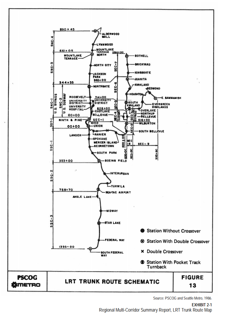
The general alignments in the PSCOG 1986 plans aren’t too different from the eventual ST2 with a branched line heading from Lynnwood to Seattle and then either east via Bellevue to Redmond or south via Sea-Tac to Federal Way. However there are some notable differences with the exact route.
From Seattle to Tukwila, rather than running on Mlk Way, the light rail line ran on East Marginal Way then via the Interurban Ave S to reach Southcenter Mall. This route added stations at Boeing Field, South Park and Georgetown though at the expense of the Rainier Valley ones.
The Federal Way and Lynnwood Link segments generally are the same with an I-5 alignment. For East Link, the line was extended out to Sammamish past Redmond and there was an additional Bothell via Kirkland to Bellevue line.
Rhododendron Line 1992
Some others advocated for a light rail similar to Portland’s light rail. Called the Rhododendron Line, the line would run at-grade in the center of SR 99 via Tukwila International Boulevard and then Aurora Avenue with signal priority. The line would connect downtown Everett, Aurora Village, Green Lake, Woodland Park, Seattle Center, the Washington State Convention & Trade Center, the Kingdome, Boeing Plant 2, Sea-Tac Airport, the Tacoma Dome, and downtown Tacoma. The northern section would somewhat follow the Seattle-Everett interurban. The line would be closer to density but at the cost of speed compared to a freeway alignment.
1995 Plan
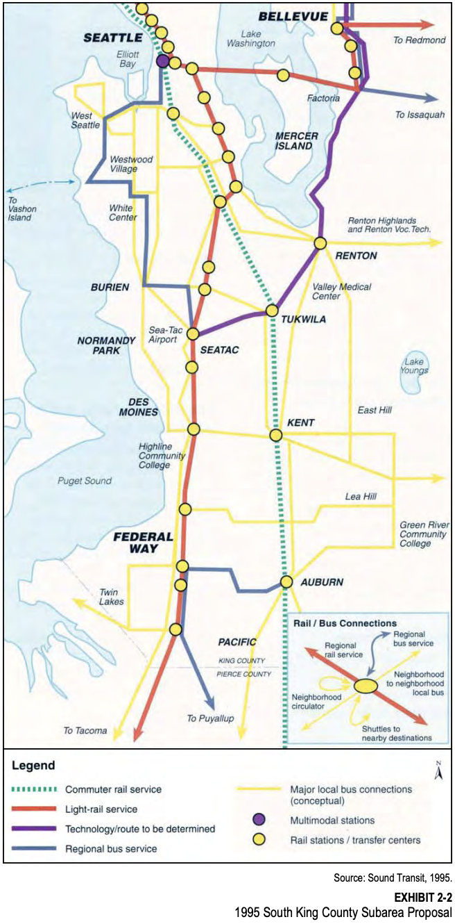
The 1995 RTA plan advocated routing the light rail through Rainier Valley on Rainier Avenue. The Federal Way alignment generally is the same as the Federal Way Link Extension. A separate Bellevue via Renton to SeaTac line using the ERC is shown in purple as well.
1996 Sound Move
The 1996 proposed plan. Unsurprisingly pretty similar to what was built. Some differences are the missing Graham and First Hill stations. The Pacific UW Medical Center station was shifted next to the Husky Stadium and the Tukwila alignment shifted next to the freeway lost the South 145th station.
1997 Environmental Impact Statement on the Proposed Central Light Rail
While the 1996 section shows the map of the preferred alternative, the EIS provided two alternatives suggested for each segment of the corridor. From the Environmental Impact Statement on the Proposed Central Light Rail (1997). The list below highlights which alternative was built or not chosen. Note back then the light rail was envisioned to run at-grade for many more sections.
- SeaTac
- (Not chosen) One route follows International Blvd. (State Route 99) from S. 200th Street, north past Sea-Tac Airport to the intersection with SR-518.
- (Built) The other alignment starts from the same location at the south end of the City and follows 28th Street, using Sea-Tac Airport property traveling north to connect with the SR-99 route.
- Tukwila
- (Not chosen) One alignment would use Pacific Highway South (State Route 99) between the SeaTac city limits and Boeing Access Road.
- (Not chosen) The second alignment would travel east from State Route 99 along State Route 518 and continue east past Southcenter Mall. The line would proceed north along Interurban Avenue to I-5 at Boeing Access Road.
- (Built not listed) Followed along I-5 instead
- Rainier Valley
- (Built) One follows Martin Luther King, Jr. Way from Henderson Street north to McClellan Street.
- (Not chosen) The other follows Rainier Avenue South between the same locations
- SODO/Little Saigon
- (Not chosen) One alignment would run north along Rainier Avenue past I-90, before heading west to connect with the existing International District tunnel station.
- (Built) The second alignment would explore the feasibility of tunneling under Beacon Hill, beginning just west of the intersection of Rainier Avenue and Martin Luther King, Jr. Way. The route would connect with the existing E-3 busway at South Lander Street and would travel north to the International District tunnel station.
- University District
- (Built but adjusted) One alignment is a tunnel beginning under I-5 east of the existing Convention Place tunnel station. The tunnel would loop south to serve First Hill, then continue north under Broadway Avenue and 10th Avenue East. The tunnel would continue under Portage Bay and 15th Avenue Northeast in the University District.
- (Not chosen) Another alignment would run north from the Downtown Seattle Transit Tunnel at the Westlake Station underground through the Denny Regrade and the Seattle Center areas. The route would continue northeast through south Lake Union and the Eastlake/Fairview area, adjacent to I-5. The route would leave the tunnel north of SR-520 and would cross the Ship Canal on a new high-level bridge parallel to the existing I-5 bridge. The route would continue east along Campus Parkway and reenter a tunnel under the University District.
1999 Articles
Rail Route Creates Hard Feelings — Northern Cities, Rainier Valley, Tukwila Feel Slight
- The city of SeaTac: Although the trains are to have stations at South 154th Street, a new airport terminal and South 200th Street, SeaTac officials had hoped for an additional station near its city center. Sound Transit officials said that many stations weren’t needed.
- Tukwila officials: They failed to persuade the board to reroute the trains to Southcenter.
- Cities in North King County. Officials from Kenmore, Bothell, Shoreline and Lake Forest Park: protested that since the trains weren’t going to go as far north as Northgate, their citizens weren’t getting anything for their tax money. They complained that they were being left out because they didn’t have direct representation on the board.
- Rainier Valley residents: hoping for a tunnel instead of surface trains. Although there was public testimony about a tunnel, the board didn’t bring it up. “There is not one elected official willing to fight for our community,” protested Michael Washington, a Rainier Valley dentist.
Rainier Valley Decisions
The Light-Rail Transit Plan — On Wrong Track?
| … In 1992, the city persuaded planners to put the line through the Rainier Valley. Planners first discussed a subway through Southeast Seattle, but Johnathon Jackson, a Sound Transit manager for community relations, said local residents supported surface or elevated tracks to spur development. Those were the two options included when the transit plan was approved by voters in 1996. In 1997, Jackson said community groups and residents pushed to get the elevated-track option eliminated. Rainier Avenue business owners got the route shifted to the wider and less developed MLK Way. … Others still favor the street-level system and are pleased by Sound Transit’s promise of a $50 million community investment fund for Rainier Valley. |
Many have decried how Sound Transit built at-grade tracks in Rainier Valley with the slow speed and fatalities against community wishes. However, contrary to popular belief, Sound Transit actually first proposed a subway down Rainier Valley using Rainier Avenue. This was rejected in favor of at-grade or an elevated alignment. Sound Transit then proposed an elevated option which was again rejected by the community, leaving only the at-grade alignment.
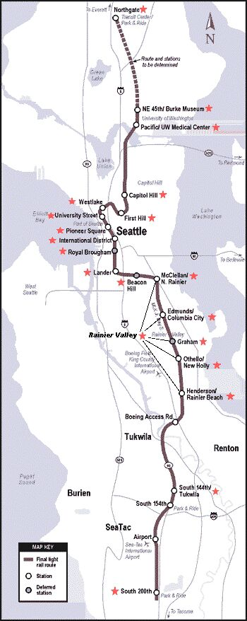
2001 North Link Record of Decision

The record of decision for North Link discussed many different alternatives. The main ones differing majorly from the actually constructed Link will be listed here, while others similar to the preferred alternative will be skipped.
Various alternatives were proposed in UW with NE 45th station or Brooklyn station in the north side. For the south end of UW, Sound Transit proposed either Southwest Campus station, Pacific station, Montlake/Rainier Vista station, or the actually built University of Washington (Husky Stadium) station.
2002 Monorail Plan

Fed up with the slow pace of Sound Transit initiatives, others proposed the Seattle Monorail plan. The elevated monorail would travel from Ballard to Downtown Seattle via 15th Ave W. The monorail would travel through downtown via 2nd Avenue on center median columns before heading south on 1st Avenue towards West Seattle.
2002 WSDOT I-405 analysis

For the I-405 corridor, while generally focused on freeway expansions WSDOT also analyzed multiple corridors for where to build fixed guideway transit. The Bellevue via Renton to SeaTac line from 1995 was detailed further, as well as an interesting interchange at Factoria for Issaquah’s light rail. The Kirkland Link is extended north via Woodinville to Lynnwood. A bit more time will go into explaining this plan since WSDOT checked the feasibility of the route and provided detailed maps.

The south end of the line would interline with the Line 1 at Tukwila International Boulevard Station (similar to the Burien/Renton Extension). The line would then continue elevated east and then cross south of I-405 and then tunnel under I-5 to reach Southcenter. The line would then continue east to the Tukwila Sounder station and then transition to an at-grade profile. The line would continue at-grade in the Grady Way median until transitioning back to an elevated alignment until downtown Renton. The line would then head north until N 8th street transitioning back to an at-grade alignment, stopping at Sunset Boulevard, and then continuing north via the ERC until Bellevue.


The Seattle, Bellevue, Issaquah and Renton light rail had a very interesting interchange. An elevated Factoria station would have served all north/south/east/west directions as an X pattern. Trains from Seattle or Renton could head to Bellevue or Issaquah as well as vice versa. However, trains could not go from Issaquah to Bellevue (as currently planned) nor Renton to Seattle.
For East Link, the WSDOT plan had the light rail running on Bel-Red road on an aerial alignment instead of running on Spring Boulevard. The line would then head north and continue on SR-520 to Microsoft and then downtown Redmond.
For Kirkland, the light rail would continue north along the ERC at grade. The line at NE 68th Street would transition to an elevated alignment and head north up State Street to reach downtown Kirkland. The line would then head east on Central Way and then rejoin the ERC at-grade until Totem Lake.


North of Totem Lake, the line would continue aerial until re-entering I-405. The light rail would stop at Canyon Park on the north side of I-405 and then continue north along I-405 until rejoining the Lynnwood to Everett Link segment along I-5 at Ash Way station.
2008 East Link HCT Plan

From the East King County Subarea High Capacity Transit (HCT) Appendix N (2008) a couple different routes were analyzed for the potential East Link. The starter East Link constructed wasn’t too different from the above map. However, for the South Kirkland to Issaquah Line notably it is extended north to Totem Lake via the ERC. Also the line would travel to Issaquah through South Bellevue station and then directly to I-90 rather than via the ERC. For Issaquah, the line (at-grade) would run on 17th Avenue and then Sunset Boulevard to reach downtown Issaquah.
2010 and beyond
Sound Transit for ST2 decided on the Lynnwood Link and Federal Way Link extensions. For ST3 Sound Transit decided on the alignments for Everett Link, Tacoma Link, West Seattle Link, Ballard Link and Issaquah Link. Others light rail line proposals such as Lynnwood via Bellevue to Renton Link were removed in favor of Stride BRT (freeway bus). The Ballard to UW tunnel and possible SR-520 light rail were briefly proposed. The West Seattle via Burien to Renton Link was too expensive for relatively medium ridership. Some other ST4 ideas were extending the Ballard Link north to Northgate and eventually to Bothell. These will possibly be detailed further in a future article.
Thought and Conclusion
There’s been many past light rail proposals throughout the Seattle metro area. While currently Sound Transit is facing large cost overruns, hopefully in the future there’s still much potential for light rail expansion to connect the region. The older plans used aerial and at-grade alignments instead of ridership poor at-grade freeway or incredibly expensive tunneled alignments.
References
- Environmental Impact Statement on the Proposed Central Light Rail (1997)
- North Link Record of Decision (2001)
- Seattle Monorail (2002)
- I-405/SR-167 Corridor Plan (environment tab)
- WSDOT I-405 EIS Analysis (2002)
- WSDOT I-405 EIS Appendices (2002)
- Appendix M shows the detailed maps
- East King County Subarea High Capacity Transit (HCT) Appendix N (2008)
You’re missing Woodinville.
Woodinville is mentioned in this other study.
Woodinville wasn’t considered part of the corridor back then (for the I-405 Corridor study purposes).
What I would like to see is a direct cost/benefit comparison between STRide and commuter rail options (for the shared segments).
It’s talked about in the 2002 study.
> The Kirkland Link is extended north via Woodinville to Lynnwood.
I wonder if there was any conclusion on how to proceed with the Ballard to UW link. Is it like something they would consider if there is next run or they have concluded not to move forward?
ST hasn’t said anything beyond that it’s not in ST3. It studied the corridor in the mid 2010s, so it could pick it up again any time it likes.
For ST4, previously-studied corridors are presumed to be at the top of the priority list, but ST hasn’t yet decided what might be in ST4 or whether there will be an ST4. It probably won’t decide until the late 2030s at the earliest ST3 is 50% larger than previous rounds, so it contains some of what was previously assumed to be in ST4.
Many transit fans are so dissatisfied how ST3 has evolved after the vote that their support for any more large ST#’s has eroded.
Yeah, it would be the most logical next project. It really should have been done before any of the major projects in ST3. In that sense it is kind of like going out to the airport before the UW. Obviously the wrong order but that is what they decided to do.
In this case though it is quite possible they just run out of money and/or political will. It is unlikely that ST3 gets built without another vote and it is quite possible that vote is simply to finish off ST3. At that point the system will likely be struggling financially (given its huge overall size and relatively low ridership).
It is possible it could be a city project given its obvious value. It is relatively small and clearly beneficial to a huge number of riders. To benefit more riders you would have to build something huge which seems unlikely (especially if you are unwilling to run on the surface).
There will be an ST3 article tomorrow if it’s ready, and an open thread, so please keep more extensive ST3/ST4 discussions until then when we’ll have more context. This article will help set the background for that.
> I wonder if there was any conclusion on how to proceed with the Ballard to UW link. Is it like something they would consider if there is next run or they have concluded not to move forward?
Generally they didn’t want to build ballard to uw anymore and instead continue north from ballard via crown hill to northgate and eventaully to bothell. Or at least that was the latest “plans” in late 2010s. Those are pretty far off and were just a sketch though.
> …and instead continue north from Ballard via Crown Hill to Northgate and eventually to Bothell.
As a recent transplant to Bothell this would be fantastic. Bothell city government is doing its best to densify the downtown area, and I have a feeling that the next 20 years will continue to change the feel of the area just like the last 20. Things I sadly foresee getting in the way of this plan though:
– Lake Forest Park’s NIMBYs/lack of densification
– Not wanting to invest in a corridor that already received STRIDE
Also, I’m sure such a line wouldn’t be complete until 2060 at the earliest.
@MRR
It’s a bit complicated and depends on how willing both sound transit is willing to build at grade center median light rail and if bothell (and Seattle, lake forest) want light rail along the corridor.
There’s not enough density nor money to build underground or elevated along the corridor.
> Not wanting to invest in a corridor that already received STRIDE
It’s like a 2040 project so I don’t think it’ll block it. It’s not like having the rapidride d and c stopped the west Seattle and Ballard link planning
@MRR
But yeah if you want to know more about it
https://www.soundtransit.org/sites/default/files/P-02%20-%20P-09%20HCT%20Planning%20Studies.pdf
There’s supposed to be future studies for st4 (study is just for feasibility)
Ballard link future extension => north to crown hill=> then to east northgate => up bothell way to lake forest park and bothell
South Kirkland future extension=> north to downtown Kirkland and totem lake => then further north along i405 to bothell (similar to what listed above)
https://www.soundtransit.org/sites/default/files/HCTEnvironmentalStudy-1.pdf
A lake city way branch of light rail would be fantastic. It’s one of the more dense areas of seattle not served by any hct at all. Forward Thrust ran a line down the corridor and I think that something similar would be great. As for at grade or median running, I don’t think that the larger voting populace has appetite for it given the pushback to the MLK segment has been so great recently. Plus, it prevents other future things like automation so the less at grade the better.
> As for at grade or median running, I don’t think that the larger voting populace has appetite for it given the pushback to the MLK segment has been so great recently.
I don’t think the pushback is that great among the voting populace itself. At-grade light rail is still built along say maryland with the purple line or say the phoenix light rail extension. Even the los angeles k line has at grade crossings.
> Plus, it prevents other future things like automation so the less at grade the better.
I understand many here do not want at-grade running but it is the difference between having no light rail at all along the corridor. If one wants light rail to bothell within your lifetime, it’ll have to be at grade or not at all.
At grade and median running are two different things.
A large part of Link has at grade segments. So do other systems. It’s cheaper to build. As long as the stations themselves are designed to avoid losing land to pavement and right of way, the tracks in between can be ok at grade.
Arterial median segments are another story. They’re ok in small doses. They are better if the street isn’t 90-100 of tracks and pavement for someone to walk across or compromised by lots of turning vehicles . This is to me the key deficiency with MLK.
I would honestly think that connecting it to UW would be easier than having it cross another underwater tunnel or bridge.
Not rail but in the early 1980s Metro had a plan to greatly expand the Trolleybus system. I still have copies of their flyers announcing the routes that would be electrified. It never happened. The only really new Trolleybus route since then was the 70 in the 1990s.
There was also a proposal in the 1970s to demolish the catinary for the trolley buses. That was thwarted by a lawsuit from the Seattle chapter of the Washington society professional engineers, WSPE, spearheaded by a number of engineers who worked for Seattle’s Transit system. WSPE initially stopped King county from destroying the catenary. Later King county prevailed on appeal but at that point more people understood the advantages of electric trolleys and wanted to maintain them and even expand them. King County also fired the general manager who was very pro diesel bus, his background being with Detroit diesel buses. It’s a fascinating tale of the power of a small organization to effectively turn the tide on some poor ideas from executives at the top of a very large organization. Some of the people who filed the lawsuit and argued it are still active today and a source of great wisdom and some fun stories.
I remember a poster then that said “Trolley wires are coming to Ballard”, referring to the 15 and 18. It never happened, and I don’t know why.
Maybe when the energy switched to building the downtown tunnel and envisioning future rail, people lost interest in trollification.
It was called the “Trolley Expansion Project” and included 71-2-3 and maybe more. 15 & 18 were to be first. If there’s an archive for old transit ephemera I’d love to scan and/or donate the literature I have.
They rebuilt the whole system shortly after I moved to Seattle in the late 1970s. I loved that my new city had zero-emission electric buses. .
https://www.flickr.com/photos/viriyincy/2554634211/in/album-72157605455785250/
The 1983 plan was posted by Oran
I still feel that extending the trolley network would be far better than investing in charging stations for BEBs until BEB technology has matured.
“Maybe when the energy switched to building the downtown tunnel and envisioning future rail, people lost interest in trollification.”
Lost interest in trollification… I sure hope people don’t lose interest in “trollification”. Electric tracked trolley’s are superior to busses in many key aspects including cost/mile/passenger (based on same-route cost analysis), maintenance, and ride quality and should be an indispensable tool in the mass-transit toolbox. Especially for bus routes that are well established with good ridership.
My understanding is Seattle’s Streetcar/Cultural Connector is estimated to have ridership even higher than the West Seattle Light Rail. Does anyone know where to find the cost estimate line items for the 1.2 mile Seattle Streetcar/Cultural Connector? Street parking removal is the source of the political pushback, of course, and my suspicion is the cost estimator was instructed to come up with an insanely high number for this 1.2 mile route. Still it would be very interesting to review the line items that went into this cost estimate that increased a 1.2 mile line to close to half a billion dollars ($410M), more than two orders of magnitude than laying 1.2 miles of track and one order of magnitude more than even the most wildly expensive urban trolley. That cost estimator is an evil genious!
@jmath
the problem is that 1st avenue is a bit complicated. it is effectively actually a “bridge” above the remains of the ground floor of old seattle. It cannot handle the weight of the streetcars so would have to be rebuilt. The other problem is that the two streetcars systems are not interoperable with each other. probably the slu streetcars will have to be sold off and replaced with new ones.
There are some interesting conceptual alignments from a study done by Delew Cather & Co (same consultant firm that did the 60s plan) for metro in the late 80s involving potential alignments for light rail. One alignment proposal was to use SR 509 with an alignment serving Burien to Seatac via 518, then to Star Lake via 99. Another route proposal split from i90 to run light rail down rainier to longacres. I have scans of the alignments studied, I just need to put them in an imgur link
FYI
Deleuw Cather was gradually absorbed into the Parsons Corporation after selling out in the late 1970’s. It was fully absorbed into the Parsons Transportation Group in the 1990’s. Of course, the entire consulting staff on the study have long since retired or passed away. It was many decades ago now.
Here’s a link to a Pedons Corporation new release about their work on the Federal Way Link Extension. The company is still a major ST engineering consultant.
https://www.parsons.com/2024/05/federal-way-link-extension-fwle-project-receives-envision-platinum-sustainability-award/
https://imgur.com/a/pVWbsSj
Link to the scan, the order is totally off so sorry, I’ll try to sort it when I have more time today.
When I look at a rail plan, I pay attention to several things:
1. Different functions for stations.A good system is usable for different purposes, meaning that destinations near stations should vary. If it’s all offices it’s not as useful as one with a big university, hospitals and shopping too. The dumbest thing to do is to build a string of parking garage oriented stations but no real destinations – as it ends up with very strong directional peak travel like a commuter train rather than a useful urban rail system.
2. Barbell stations. The more station areas are designed with something at each end, the better. When there’s just one central entry the TOD acreage and possibilities are smaller.
3. Branching at both line ends. Not only can branching provide better coverage, but it adds more driver break time as well as time needed to reverse a train. Consider that our 1 and 2 lines are a branch at one end of a trunk — and that some branch at the other end is a real opportunity lost while turn around at Lynnwood will be stressed for time. It’s just better for operations. A branch to Lake City, 99 or even Paine Field and Everett as the two ends makes more sense to me.
4. Number of stops to a destination. I think riders get stop fatigue after about a dozen stops. Bigger systems have skip stop or express segments. 18-22 stops between Tacoma Dome and Downtown Seattle is a bit much. If you’ve ridden a CTA Red Line train from Howard Street to Downtown Chicago (about 20 stops) you get why I’m saying.
I have a book someplace from the 1920s or 30s that has a subway to Magnusson Park. So there is that. Planners gonna plan.