
The Puget Sound metro area has made significant effort in expanding transit with both its light rail network and side-running BRTs like RapidRide and Swift. These have established a better transit baseline than many American regions have, enabling people to get around easier. Recent Link extensions like Lynnwood Link and the starter East Link, and future projects like Downtown Redmond, full East Link across Lake Washington, and Federal Way Link, are set to enhance regional connectivity. However, while these extensions are excellent for improving commuter routes and replacing express freeway buses, their freeway-adjacent alignment often bypasses significant job, retail, and residential hubs along existing avenues. This leaves many high-density corridors such as Aurora Avenue, Evergreen Way, Pacific Highway South and Rainier Avenue South underserved.
Enter — Center-running BRTs. Operating in dedicated lanes separated from general traffic, they offer a combination of moderate-high reliability, faster travel times, and relatively low cost compared to light rail. This makes them particularly well-suited for connecting dense urban corridors that are underserved by existing transit.


Cities across the US have successfully have successfully implemented center-running BRT systems. San Francisco build the Van Ness BRT. Richmond, VA, built the Pulse BRT. Madison, WI implemented the North South BRT. These examples highlight the potential for center-running BRTs to complement existing transit networks and address gaps in service. They have quite long continuous sections with center-running bus lanes. They can still allow for two lanes of cars in each direction.


For more constrained corridors, compact center-running BRT systems can fit into narrower 4~5 lane corridors. These still allow for one general lane in each direction with dedicated left/right turns. For example, AC Transit built the 9.5 mile Tempo BRT connecting Oakland, Fruitvale and San Leandro, CA. Denver, CO plan a 5.5 mile Colfax BRT connecting to Aurora.
Seattle itself also recently constructed Madison BRT on Madison Street with some portions of center-running bus lanes. But it does not quite reach the scope of the previous examples because it stays within the city borders and only travels 2.5 miles.
Corridors to Improve based on Ridership
| Route | Weekday Boardings 2024 Oct | Route | Weekday Boardings 2024 Oct | |
| RapidRide E | 13,568 | Route 40 | 8,539 | |
| Route 7 | 11,314 | RapidRide C | 7,488 | |
| RapidRide A | 9,618 | Route 62 | 7,126 | |
| RapidRide D | 9,309 | Route 36 | 7,059 | |
| RapidRide H | 8,636 | Route 44 | 6,663 |
The top 10 King County Metro bus routes by ridership are listed above. RapidRide E, Route 7 and RapidRide A as the top 3 ridership routes are the best candidates to implement center-running BRT. Additionally Community Transit’s highest used bus route Swift Blue with ~4,000 daily riders is also a good candidate to improve.
Swift Blue, RapidRide E, and RapidRide A are all on wide stroads that are easiest to convert to a center-running BRT. We’ll start with upgrading Swift Blue from a right-side BAT lane BRT to a center-running BRT in this article. Other corridors will be discussed in future articles.


Some of these top-ten routes and other bus routes have other long-term plans. RapidRide D parallels future Ballard Link. RapidRide H and RapidRide C will likely be replaced or truncated by West Seattle Link. Route 40 as a center-running tram (same alignment with center-running BRT) was already described in the Ballard Light Rail At-Grade article. Other high-ridership Sound Transit express bus routes are already being converted to the Stride (freeway) BRT.
Bus routes on medium-width avenues such as Route 7, Route 44, Route 36, and Route 150 were discussed in RapidRide prioritization plans. These will require a more compact center-running BRT alternative. Routes with a local+express pattern that are partly on a freeway such as Route 101/101 to Renton or Route 150 to Kent will require direct connectors between their centermost freeway lane and the arerial avenue they switch to.
Evergreen Way Center-running BRT (Swift Blue)


The Everett Link extension runs along I-5 north to Mariner, then northwest along Airport Road, then east along Casino Road, before finally heading north along I-5. Community Transit’s Swift Blue line runs from Everett on Evergreen Way via Lynnwood and Shoreline to Shoreline North station. Notably, the bus route skips Lynnwood City Center station in favor of remaining on Aurora Avenue.
A center-running BRT would provide fast frequent service on the areas skipped by Everett Link, and help complement the light rail line with connections both at the ends of the bus line with Everett Station and Shoreline North as well as in the middle with Airport Road and Evergreen stations.
Starting from Everett Station, the BRT would follow the existing path of Swift Blue heading west on Pacific Avenue and then heading south on Evergreen Way. The roadway of Evergreen Way north-east of SR-525 is 85~90 feet wide (~100 ft including sidewalks), wide enough for 3 general lanes and 1 bus/HOV lane in the center.


The intersections would need to be widened by roughly 20 feet to maintain 3 general lanes, left turn and center BRT stations. Given that most of the corridor is lined with parking lots, while difficult it wouldn’t actually be too cost-prohibitive to widen.


Alternatively, if only 2 general lanes in each direction are required, construction would be much simpler. The existing center turning lane could be maintained while the centermost traffic lane could simply be repainted red. At intersections, there is just enough space for 2 general lanes in each direction along with a left-turning lane.
Lynnwood to Everett HCT study
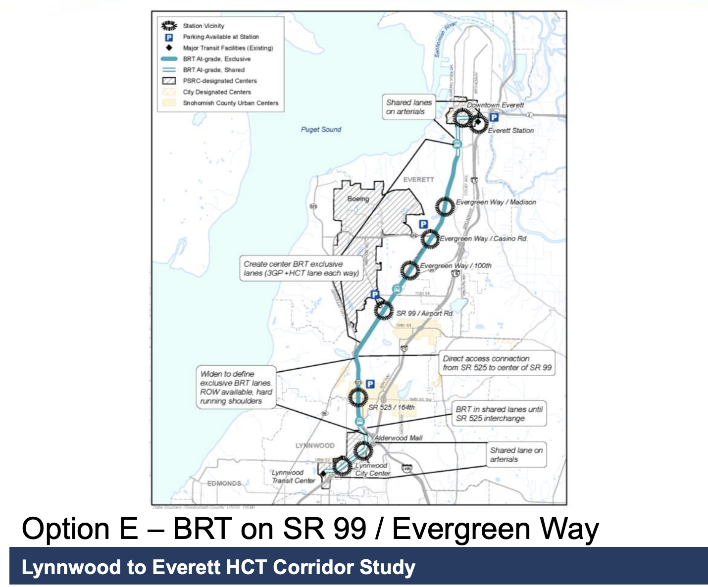
The Lynnwood to Everett HCT study partially investigated such a center-running BRT on Evergreen Way. The study proposed 3 general lanes in each direction along with the center BRT lanes, somewhat validating that it is possible. However the alternative also proposed routing the line down a direct connector flyover from Evergreen Way to SR 525, then continuing south to Lynnwood City Center station (thus not serving Highway 99 south of Edmonds College). The line had wider station spacing than the existing Swift Blue line, 2~3 miles instead of 1~2 miles.
If the Everett Link extension is built, sticking with the existing Swift Blue alignment and closer stop spacing makes more sense. Riders heading to Everett or Lynnwood could instead transfer to the light rail, while shorter trips or those starting/ending on SR-99 could use the center-running BRT.
Evergreen Way BRT Travel time and Costs
| From Everett Station | to Airport Road | to Aurora Village Transit Center | to Shoreline North station |
| BRT without traffic | 18 minutes | 39 minutes | 48 minutes |
| BRT with traffic (noon not morning) | 24 minutes | 53 minutes | 66 minutes |
| to Airport Road | to Lynnwood City Center | to Shoreline North station | |
| Everett Link | (estimated) 18~20 minutes | 34 minutes | 41 minutes |
A BRT would be usually be moderately slower than a grade-separated elevated light rail line, but the BRT in this case has the advantage of running straight down Evergreen Way, while the Everett Link detours to reach Paine Field. The current off-peak bus times for Swift Blue from Everett to Airport Road are about 18 minutes — the same as the light rail line. Reaching the Aurora Village Transit Center on the BRT would take 39 minutes without traffic (currently 53 minutes with traffic). Reaching Shoreline North station on the BRT would take 48 minutes without traffic (currently 66 minutes with traffic), while the light rail can reach Shoreline North in 41 minutes.
Evergreen Way BRT Density and Stop spacing


Evergreen Way is kinda auto-centric but it still has garden-style apartments along certain portions. The street is also relatively easy to infill in the future for further density. In comparison, the Lynnwood Link Extension and upcoming Federal Way Link Extension both stick close to the freeway with low density

The existing Swift Blue line runs for 16.7 miles with 18 stops, creating on average a 1 mile stop spacing in between stations. Unfortunately while an average 1 mile stop spacing is right on the verge of being unbearable, other sections have stop spacings of 1.5 or up to almost 2 miles around North Lynnwood.
Currently Community Transit minimizes the number of Swift Blue stations to decrease travel time and subsequently allow more buses to run the route at the same time. This allows for 10 minute frequency even with it’s long length but heavily decreased access. Assuming the Everett Link Extensions exists for longer transit trips, the Evergreen BRT could stop more often near apartments and retail stores sacrificing a bit of travel time for access to destinations.
Evergreen Way BRT Costs and Benefits
The cost of the center-running BRT with 3 general lanes might be relatively high, given the large intersection reconstruction at each station stop. There would be some property takings but generally only parking lots. The Option E from the HCT Corridor was studied at around ~$500 million dollars in 2015. The estimate can be used as a ballpark figure, given that we’re adding an extension to Shoreline North station but subtracting the costly flyover to SR-525. Adding some inflation and post-COVID cost inflation construction would land an estimate around $700 million dollars.
For only maintaining 2 general lanes, the BRT would be much cheaper $300~400 million. The long length of the BRT line (17 miles) would typically involve massive utility relocation along the entire length. Given the relatively long stop-spacing distance, I suggest instead not adding physical barriers to the BRT line, and just painting the center lanes red. This would allow buses to detour around utility repairs in the center bus lanes by merging to the lane to the right and skip digging up the entire road. The BRT stations at intersections would require some utility relocation but not require any road expansion.
One difficulty that challenges center running BRT is the time it takes for riders to cross the street. If the street is overly wide the crossing time gets pretty long. Then adding bus priority to that makes the wait to get to the stop even longer!
Crossing safety is no incidental concern. MLK is notorious for risky moves and resulting accidents. The faster the highway traffic, the greater the risk. The longer people wait for a green light and are more apt they are to break the law and task risks (jaywalking, running red lights and speeding).
Finally, drivers may pull into the median bus lane by accident. Unlike a curb lane with striping, I’m assuming that a median lane will be more separated — unless buses have left doors. This a wayward driver has no wuick way out. But left door bus stops in the median can’t be used by other buses with only right doors. That means that bus transferring will require crossing a busy street or even two.
The design is what matters. But building in the median of a wide road like MLK is not safe generically — even if its for buses only. It may be even more dangerous than light rail because rail is more obviously a place to avoid more then a median busway is.
Finally, drivers may pull into the median bus lane by accident.
Sure, but that seems way more likely with a BAT lane than with a center running lane. In fact, with a BAT lane they pull in there *on purpose*. This makes it even more likely that someone will accidentally (or illegally) use the lane. In terms of right-of-way and accidental violations I would say the order is like this:
1) BAT lanes. These are violated all the time as people have a very loose definition of “next intersection” (with the “right turn only”).
2) Short stretches of bus lanes. Drivers don’t quite understand why they are there.
3) Center bus lanes. Drivers are going the same way and some of them mistakenly think it is OK to drive there.
4) Contraflow lanes. These tend to be very well marked with “Do Not Enter” and “No Right Turn” (or left turn) signs. Violations are pretty rare. But the street still has ordinary cars and lanes that appear to be going that way, so once in a blue moon somebody goes that way (just like people sometimes go the wrong way on a one-way street).
5) Transit mall. Similar to contraflow lanes in that it is clearly marked. But the fact that a driver only sees buses might add a level of certainty that contraflow lanes lack.
Of course any change will lead to an increase in violations. Add special lanes a lot of people (who were used to using those lanes) ignore it at first.
Another issues is time limits. It is pretty common to have a lane that only applies to rush hour, which leads to more violations. I’m sure plenty of traffic cops have heard the “I’m sorry, officer, I didn’t realize what time it was” excuse.
The issue is not only about accidental lane intrusion — but it’s also how easy it is to get out of the lane when a driver mistakenly gets in one. If there’s a curb, the driver may be unable to get out without backing up or driving to the next curb break.
BAT lanes are fully porous. A mistaken driver can swerve out of the lane relatively easily (as long as there’s a gap in the traffic). That does enable more intrusion ; — but it also prevents accidents.
This is why I said that careful design is key.
One difficulty that challenges center running BRT is the time it takes for riders to cross the street.
Yes, but more often then not, this is more than made up for with the increase in speed. The increase in bus speed has another benefit: buses can run more often (at no extra cost).
But left door bus stops in the median can’t be used by other buses with only right doors.
We had a long discussion about that before this got published. Long story short: That is an implementation detail for this corridor. There are two additional buses that use the corridor (other than Swift Blue): The Community Transit 101 (that runs every half hour midday) and the Everett Transit 7 (which runs every fifteen minutes). So the corridor is not particularly complicated when it comes to additional routes. In my opinion it is likely that the “weave” approach is better, as you don’t need special buses. But it may be that just buying enough buses with doors on both sides is cheaper than implementing stops like that. Either way though, it would make sense for those other buses to share in the right-of-way. It seems like a poor design otherwise.
But building in the median of a wide road like MLK is not safe generically — even if its for buses only.
So you are saying that Link should have been built to one side, with traffic going both directions to the side of it? Hard to see that being safer. Running the trains down the middle of the street is fairly standard the world over.
I’m only saying that the current design of MLK is particularly dangerous.
As I’ve opined before, I think a better generic approach is to put the traffic to one side, then have the transit corridor, then have the bicycle path or multi-use trail. That makes the street much shorter for a pedestrian to cross. But that’s in cases where streets or highways are very wide and there are few driveways or cross streets. It’s all context sensitive.
I think breakaway gates may be a good basic deterrent. Maybe a median busway just needs gates to take away the risk from wayward drivers.
it would be safer for anyone getting in or off on the appropriate side because they don’t have to cross to get to the dangerous and precarious median
As I’ve opined before, I think a better generic approach is to put the traffic to one side, then have the transit corridor, then have the bicycle path or multi-use trail.
Yes, but at that point you’ve changed the assumption. Basically what you are arguing is that the street would be safer if there were fewer lanes. Well of course it would. That isn’t the issue.
I’m saying assume we have two lanes of general traffic each direction (like we do now). Running the trains curbside works, but you have to add special traffic lights at each intersection. You don’t want a car turning right (in front of the train) and then stopping for some reason. Here is an example in Vienna: https://maps.app.goo.gl/uSm2RFccQsjMLv2H7. This means that the signal phase is longer. That means that even though the train avoid congestion it (and everyone else) has to deal with a longer signal phase.
Note: That kind of arrangement is unusual, even for Vienna. Typically it runs down quieter streets in the middle of the street, like so: https://maps.app.goo.gl/ADPNn5nHCGem96MU6. Here is an example from the suburbs (the focus of this post): https://maps.app.goo.gl/JeCRMctdErcsZaVf9. Here is an example of a busier section in Melbourne (which has the largest tram network in the world): https://maps.app.goo.gl/a7RV9SmyoJnZNPkS6 (notice that both lines run in the middle of the street with cars on either side). They both have their advantages but it is pretty standard to run the tram in the middle of the street. There are advantages to running curb side but it means a much longer signal phases.
What is true of trams is true of buses. You can run them curbside but that means you need special traffic signals at each intersection. And how exactly do you deal with cars turning into driveways? Now we are back to the original Vienna example. That road is so wide (with most traffic going one way) that local traffic is off to the side. That is great — it means it isn’t a “stroad” — it is a road in the middle with streets on both sides. But our stroads are not wide enough (especially if we want multiple car lanes going both directions).
“Typically it runs down quieter streets in the middle of the street, ”
Yes this is better for trams. Slower, quieter streets. Yeah! It’s also what Link does in near BelRed Station. There’s a median track with one slow lane on either side.
It’s the mega-wide higher-speed highway that’s doing everything that I think is dangerous for a median arterial busway. The objective is to emulate Link and run on faster roads that’s are loud and busy mega-highways and that’s not pleasant.
I get that trying to turn a mega-wide highway into a transit street is inherently introducing speed for the buses.
Maybe the better strategy is to run in the median but make the stops grade-separated. Riders can easily walk across a two lane busway in the air without a mezzanine, and two small entrances at two corners could be the ends of a walkway about 25 feet higher than the street to reach the stop. Buses can easily run up at 7-8% to the stop and back down again.
Bogata and Curitiba both design the stops in mid-blocks when they do cross traffic, and don’t push the riders to walk across intersections with lots of turning. They often have grade separated walkways to get cross busy highways. If the intent it to go full-on South American, you should propose stops that way — and not stop where riders have to cross in front of lots of turning traffic to get to the bus.
I know it’s expensive — but grade separated stops with pedestrian overcrowdings to two corners would be the ideal. Cost cutting could be done from that depending on the activity. But aim for safety rather than just speed.
I don’t know if that is actually safer. People tend to avoid pedestrian overpasses. You can see that at Aurora and 130th. There is a nice pedestrian overpass *and* a crosswalk. People often just cross at ground level. So you’ve spent a lot of money and plenty of people have ignored the infrastructure. I don’t see it as a great use of money when it comes to safety. It makes sense if you have no other choice but typically it is implemented because they are clearly favoring car-traffic, not pedestrians.
Community Transit likes to physically separate the local bus stops from the Swift bus stops. If Swift was moved into center running lanes, presumably local routes like the 101 would simply run in mixed traffic and use the same bus stops they do now, at the right curb.
@brandon
it could probably be an open brt and combine the local variant together
“People tend to avoid pedestrian overpasses.”
That’s true — if someone is fully crossing the street. But if the only way to get to the bus stop is to use one and if there is only one level change rather than two, riders will have to use them.
@al
you should take a google street maps view of van ness brt or albuerqueue brt etc…
bogota brt is not what would be built. i think you are overestimating how wide aurora avenue is. there is not enough space to build that variant. in bogota those boulevards are like 180 or like 250 feet wide with multiple 3/4 lanes and also the brt in the center of those lanes. or they might have like 5 lanes dedicated to the brt with 2 bus lanes in each direction for overtaking and 1 lane for the brt station.
@ WL:
I’ve ridden buses on Van Ness in SF. It is not a higher speed arterial. It’s more like Mercer St in SLU. The BRT segment is only about 2 miles and there is a stop light every block. Routes that run on Van Ness run further south and don’t stop at the end of the median bus lanes. It’s very different than what’s proposed here.
I haven’t been to Albuquerque. Not all of the BRT routes are in a median BRT lane. A good part of the median BRT is also next to just one traffic lane in each direction — so there doesn’t appear to have the lanes and volumes and speeds of traffic on Aurora or Pacific Highway.
Again, I’m not saying that a median BRT is always a bad idea. I’m just saying that the design has to be considered in context of adjacent traffic lanes, speeds and volumes and that can vary along a long route. And I’m saying that bus stops have to be carefully designed for safety.
It’s merely one concept in a bus lane toolbox. It’s not always going to be better than side bus lanes. It may be great for 2 or 3 miles but not so great for an entire route of 10 or 20 miles.
Being able to understand the context and nuances of any transit corridor is important. Even RapidRide G changes where bus lanes are in its short route length.
“But left door bus stops in the median can’t be used by other buses with only right doors.”
Another solution is to have the bus lanes cross over each other at the stops, in a double-X. If I remember correctly, Los Angeles does this at some points on the Harbor Transitway?
This would of course have some risks and slow things marginally, but given it’ll only be buses traveling here, and it’ll be right next to the stops where they’ll be slowing anyway, the risks should be small.
Interesting. That seems like a good compromise. You only have to build one bus stop at each intersection (like you would with buses that have doors on both sides) and yet any bus could use the stop. I guess Jarrett Walker had a post about it: https://humantransit.org/2012/06/request-for-information-busways-that-cross-over-at-stations.html. Here is a great example from Sydney: https://maps.app.goo.gl/qibW2DcLxeZmhAou6 (it is the lower road). One drawback is that you can’t easily pass another bus. Since this would be Swift (which skips stops) and a limited stop bus (like the Community Transit 101 or Everett 7) it might be an issue. It could make sense for other corridors (like maybe Jackson?). But safety remains an issue (folks are used to vehicles going the “wrong” direction).
If the street is overly wide, isn’t it better to have stop at median?
Center stop is like refuge island that make sure you will never need to walk across the whole road in one breath. Crossing distance is also the same. You will have to cross street one way or the other if your stop is at curb.
Al’s point is about the traffic light. To get to the bus stop, you have to wait for the traffic light each direction. If the stop is curbside you only have to wait one direction. But otherwise the walking distance is the same.
As stated, the disadvantage of center running is needing protected pedestrian access to the bus stops. The advantage of running the buses in the curb lane is that the existing sidewalk can function as the waiting area for riders and the sidewalk is where people actually want to go. Transit planning should focus first on moving people rather than just moving vehicles.
Bogota’s TransMilenio lines run in center lanes with exorbitant passenger access infrastructure that makes getting to and from the bus a long, difficult journey for riders. And the areas around the stations tend to be lifeless and void of anything other than people heading to the bus. Compared to Quito, where the buses run in curb lanes and the stations are integrated into the existing pedestrian infrastructure. Areas around stations in Quito are full of businesses and pedestrians.
Another consideration should be frequency. Building bus-only lanes for buses that only run every 10 or 15 minutes is wasteful. When I look at the Stride plans, I’m hoping that there are plans to eventually increase service to every 5-6 minutes during peak hours. If the project delivers on its promises, it will attract enough riders to warrant very frequent service. The same with RapidRide along Rainier Avenue.
Center stations are common around the world. It is especially common with trams. The alternatives are:
1) Transit mixing with traffic. This is common in America (even with trams) but that is not a good thing. Transit in America sucks.
2) Make the curbside lane exclusive, but allow right turns only with a right-turn arrow. I’m pretty sure this is less common. It can lead to longer cycles at each intersection. It also requires secondary streets (to the outside) for local access (if there are any local driveways). In this case there are plenty. You can compromise between the first two by allowing cars in the right lane, but only if they turn right at a driveway or minor intersection but that is likely to slow the transit vehicle down.
3) Transit mall. Requires all cars to use a street nearby.
4) Contraflow. Only works if the street is one way. A local example is part of Fifth. These can be one or two lanes. One lanes means buses have to cross over the median to pass other buses. Two lanes means they avoid that and can leapfrog easily. These can also have issues with local access as well but more from a safety standpoint. You force drivers to make a left turn into a driveway with incoming traffic. However, since the only vehicles going the other way are buses, it is less of an issue. (The main problem with free left turns involve a long stream of cars. Drivers wait and wait for an opening and then go really fast when they see a gap, only to realize too late that there are pedestrians crossing the driveway now.)
In this case the road is not going to be a transit mall, nor will it be one-way. Adding right-turn arrows and allowing turns onto minor streets seems like it would fail, miserably. Wesley is right. The best solution is center running transit.
Are Quito’s buses as fast as Bogota’s? How does Quito address cars turning in front of the bus to access businesses and residences?
@Mike Orr
I know I’m being rather pedantic; but–to me–it doesn’t matter how fast the vehicles move. The important metric is how fast the riders move from their homes to their destinations.
I think the people in Quito move faster because their high-capacity transit lines are integrated into the existing street network much more effectively than the Bogota BRT lines. There are some underground stations in Bogota’s city center that are easily accessed; but in the outlying areas, the pedestrian paths to BRT add many minutes to a rider’s trip. In Quito, the high-capacity bus routes are separated from general traffic and usually close to the curb. In both cities, the transit moves faster than private autos or taxis.
I know I’m being rather pedantic; but–to me–it doesn’t matter how fast the vehicles move. The important metric is how fast the riders move from their homes to their destinations.
That is one consideration. But how fast the vehicles move is important in its own right. As I pointed out above, the faster the vehicles move, the more often the move. When they kicked the buses out of the bus tunnel, a lot of people had a quicker trip. Going from one end of downtown to the other is often better. The buses are slower but they are right there, on the surface. But this also meant that Metro had to pay a lot of extra money just to run the buses through downtown. They run less often. If we could afford to build another bus tunnel you can be assured that Metro would send the buses in it, even though it means a longer walk for riders.
In this case we aren’t even talking about that. This is not a transit tunnel (as great as that would be). This is simply a stop in the middle of the street — which again is common the world over for trams and increasingly common for buses.
The bus priority for buses on stroads won’t need to be changed much.
If the bus is heading in the say north direction on evergreen way then it can just go during the normal through movement cycle. The main direction will already have the longest green light compared to east/west or left turns so it’s fine.
The actual signal that will need to be adjusted is say cutting short the left turn phase to allow buses to travel straight.
> Crossing safety is no incidental concern. MLK is notorious for risky moves and resulting accidents.
You still need to cross the road when you’re returning in the opposite direction
A thorough analysis of travel time benefits is needed. It may offer faster bus speeds!
However, for the rider it will require crossing the busy alterial twice rather than once per round trip. Waiting at one more light may wipe out the ravel time benefits— especially for shorter trips on the bus.
BRT or not, I think cernter-running bus lane could be a good setting for some wide arterial with good bus volumes. Especially for certain corridors where curb lanes are part-time parking lot.
where is the hell no button? It is already terrifying enough to cross Aurora when you need to board the bus or get off at the other side. The idea this will be the default for Swift and D or anything on sr99 is not just unsafe but wreckless. Rather than speeding money on center median stations that will be dangerous and overpriced, improve the exiting stations and signaling on the existing side lanes. Maybe buy some cameras to issue tickets to drivers that don’t turn right.
You act as if a center running buslane wouldn’t come with safety improvements and a road diet. I doubt that such a transformational streets project would leave Aurora in the same state with only shifted bus lanes. That would be reckless.
In any event, it could be built like the G line to be partially center running and partially side running depending on the rest of the street infrastructure.
Oh, and see Central Ave/route 66 in Albuquerque for how to build BRT in the center of an urban highway/stroad from the 30s.
The G’s side lanes are a flaw. West of 9th is side lanes because there wasn’t enough room downtown for center lanes and all the downtown car circulation and SDOT wasn’t creative. East of 17th is side lanes because ST decided not to give the G transit priority there. I discussed this with a rep at a planning open house. I said the entire route should have transit-priority lanes. He said SDOT’s models showed there wasn’t enough congestion to require it east of 17tj, and SDOT couldn’t justify spending more taxpayer money on transit lanes where it wasn’t necessary. I said make sure you can upgrade the lanes later if congestion turns out worse than anticipated.
The G’s side lanes are a flaw.
I agree. There are two areas that lack center running and they are very different:
1) Downtown. There are one-way streets here. You could run the bus in the center (New York City does it) but that only gets you so much. What you really want in that situation is contraflow. Contraflow just means that buses flow in one direction and other traffic flows the other. Once you do that, a lot of issues that currently slow down buses disappear. The main drawback with contraflow is that one bus can’t pass another bus. Since only one route runs on this corridor it really isn’t an issue during normal operation. It isn’t like Third Avenue, where buses routinely leap-frog buses (those buses would need two lanes of contraflow).
2) East of 17th is as you describe it. To be fair, this would have also meant either making the street wider or changing the nature of it. At 13th (the easternmost center bus stop) it is essentially five lanes wide. One general purpose lane both directions, one bus lane both directions and the center lane for the bus stop. The next set of stops in the east are at 17th, where the street is narrower. I don’t think you can add center bus stops there without taking some land and moving some utilities. That gets a lot more expensive. The same is true for stops to the east. In my opinion there are flaws with RapidRide G but widening the street (to add center stops east of 13th) is probably the last thing I would do.
hi all, I’m a bit surprised there’s this much concern about the safety of center bus stations. Center running brt stations are used through south america, europe, and even within america and are safe to use.
One would be crossing at the intersections, but regardless even with the curb stations you’ll still need to cross the road. It is just a difference of crossing all 6 lanes at once and then none in one direction. or crossing 3 lanes in both directions. center or curb side bus stations it does not change how many car lanes one crosses in the end.
While evergreen way and other stroads can of course be calmed down with less lanes that was a bit outside the focus of this article.
I agree. The safety aspect doesn’t make sense to me. Crossing all the lanes (within the time frame) seem inherently more dangerous than crossing only half. That is why they often add center islands. These serve no transit purpose — they are just there to make the crossing safer.
The time to access the station is a different matter. With curbside stops, half the time you don’t have to enter the intersection. But that extra time (waiting to get to the middle of the stop) is minimal compared to the speed (and frequency) improvement by running in the middle of the street. The crossing advantage only occurs one direction and the fact that you only cross half way (going the other direction) can help (depending on when you arrive at the intersection).
“It is just a difference of crossing all 6 lanes at once and then none in one direction. or crossing 3 lanes in both directions.”
It’s only crossing 3 or 6 lanes if it’s at the middle of the block. At intersections it’s crossing turning lanes too. So in one direction, a pedestrian may have to cross 6 lanes just in one direction just to get to a median bus stop — one right turn, three through and two left turn. And they likely will turn green for drivers making the three movements at different times.
Aurora and Rainier are well-known for pedestrian accidents. Any reconfiguration will need to be done with pedestrian safety in mind.
Spend some time looking at the median busways of Bogata and Curitiba when they run on wide arterials. You will see lots of mid-block stops or grade-separated stops. There’s a reason that they’re designed that way. Adding in a median busway transit stop in a wide field of asphalt and a sea of vehicles turning every which way is inviting more confusion and pedestrian accidents / fatalities.
It’s only crossing 3 or 6 lanes if it’s at the middle of the block. At intersections it’s crossing turning lanes too.
OK, then. Change the number to 4 and 8. Or maybe 5 and 10. That doesn’t change the situation. Consider a real world example. This is a crossing in Albuquerque before they added the center stops: https://maps.app.goo.gl/4VAZhs55JHt15w4E8. It is 6, maybe 7 lanes. This is what it looks like now: https://maps.app.goo.gl/CB6eqSyYp4kdbhY87. You only have to cross two or three lanes before you are at the bus stop (and one of those is a bus lane). Turn around and look the other direction: https://maps.app.goo.gl/4RKFKSJq1BBPn67X8. It hasn’t changed much over the years. Yet it is clearly a worse crossing than the one with the bus stop.
Look, I get the argument about having to wait for the traffic light. That is a real issue (that effects half the trips). But overall, having a stop in the middle is *safer*.
The reason Latin American BRT designed their ped access that way is that the traffic volumes and ridership are both enormous. They built a lot of BRT system to process metro heavy rail level transit demand.
With that kind of transit demand at station, it is not possible to process the vehicular and ped with an at-grade ped crossing. I doubt it was the safety reason that made them design their station that way.
Also, I think there are some technical challenge for them to build and operate metro.
I think the design decision in Latin America probably are not relatable to the case of US projects.
I think the design decision in Latin America probably are not relatable to the case of US projects.
Agreed.
Exactly. You need to look behind you for right turns, one or two left priority turns, any 3 lanes blowing past a red light…. just to take the bus. Center lanes will get people killed. It is as simple as that. And all for what? So we can shave a few minutes? Better spend the money on signal priority, wider sidewalks and pedestrian bridges.
Center lanes will get people killed. It is as simple as that.
That is complete nonsense. Center lanes are used all over the world to improve transit. Improving transit leads to fewer accidents and deaths.
You act as if center running transit is something new and weird. It isn’t. We have center running transit in various places — even in our city! On the freeways, through downtown, on Rainier Valley. This is just normal. Think of a tram in Europe. Chances are, it is running in the middle of the street. So you are basically saying the Europeans are doing it all wrong! They should have the trams stuck in traffic instead. Those silly Europeans — they don’t know anything about traffic safety. Is that really your argument?
Oh, and this statement is complete nonsense:
You need to look behind you for right turns, one or two left priority turns, any 3 lanes blowing past a red light…. just to take the bus.
You are describing crossing the street. How the else are supposed to take the bus? Seriously, how is that different than today? In short, it isn’t — and if anything it is worse! Think about it. You are trying to get to the Swift Blue bus stop here from the east. How do you get there? You cross Evergreen Way. This means “You need to look behind you for right turns, one or two left priority turns, any 3 lanes blowing past a red light…. just to take the bus.” Of course you do. It is the only way to cross the street. Six lanes of traffic. Arrive a little late in the cycle and you better be ready to sprint. At least with a center platform you have a shorter trip. You only have to look one direction as well.
In other words, *center platforms are safer*. Of course they are. That is why they add them, even if there is no transit there. Consider the crossing of 15th NW at NW 83rd. This is what it looked like a few years ago. Notice that tiny section in the middle of the street. Like various parts of Aurora, they knew people were going to cross there not matter what. This way, a pedestrian could cross half way, wait, and then go the rest of the way. I made that crossing many times. This is what it looks like now. They added a traffic signal. Great! I guess they no longer need those platforms, right? Wrong! They are still handy for those who have trouble crossing the entire street in one fell-swoop. It is a very wide road. So is the road that the Swift Blue runs on in Snohomish County. Having center platforms makes crossing the street safer.
“At intersections it’s crossing turning lanes too.”
Aren’t you crossing turn lane(s) too when you cross a regular intersection with crosswalk? There is no midblock crossing especially along wide arterial. So everyone is crossing at intersection anyway. Each passenger is likely to cross an intersection at least one way on a round trip regardless how your bus stop is located. Why do you think center-lane bus stop is especially more dangerous?
I can assure you that if a center-running bus stop is placed at near/far side of an intersection, no left-turn lane will have permissive phase (flashing yellow). You mention turn lanes with ‘s’. Although permissive phase is not explicitly banned for dual left-lane in national level guideline like MUTCD, you barely find intersection anywhere in the US with dual-left turn lanes operating under permissive-protected phase because that’s just not safe even for cars. These can all be mitigated by better geometric design that provides sufficient sight distance and traffic signal plan that prioritize pedestrian safety.
In San Francisco’s case, left-turn is banned at intersection where passenger access the center stations. You only find turn lanes at the block where there is no station. One reason is that it is safer while another reason is that there is simply no space for turn lane(s) after side platform takes up almost a lane. You might want to take a closer look to Van Ness’s street view and sense whether it feels safe to cross. It is a wide arterial by SF’s standard, but it is not that wide. It has almost no surface parking space next to curb. The car dealerships along Van Ness are even completely wrapped in buildings. You should really take a look of the streetview of Van Ness and see how ped access to station is set up.
“In San Francisco’s case, left-turn is banned at intersection where passenger access the center stations. You only find turn lanes at the block where there is no station. One reason is that it is safer while another reason is that there is simply no space for turn lane(s) after side platform takes up almost a lane. You might want to take a closer look to Van Ness’s street view and sense whether it feels safe to cross.”
Simply put, Van Ness in San Francisco is NOTHING like SR 99 in Snohomish County. It’s just not that comparable. The buses are more frequent. The traffic is slower. The signals are closely spaced. It is a pedestrian area where drivers expect to see them. SF can ban left turns because there are other streets that drivers can choose just a block or two away.
And as I said before, Van Ness buses don’t stop at the end of the median bus lanes. They keep going! It’s used only for part of a route; not the whole thing.
Just because some cities use median bus lanes for an part of their route doesn’t mean that the entire route has to be in the median. And when there are lots of turn lanes required at intersections, safety has to be more carefully considered. Drivers easily can end up turning into a bus lane— especially when it’s a left turn — and they’ll need a way to get quickly out of it.
And a stop with a separate crossing signal a block away from a major intersection is going to be safer because there wouldn’t be turn lanes. It’s a reasonable solution to reducing pedestrian crossing distances as well as gives pedestrians better sight distance because they wouldn’t have to worry that some car will turn into the road and surprise them.
Just because some cities use median bus lanes for an part of their route doesn’t mean that the entire route has to be in the median.
No, but the more the bus runs in the median the better. That doesn’t mean the bus would run in the median on 185th or Pacific — but center running buses along the entire north-south corridor* of the route would be ideal, appropriate and quite similar to what other cities have done, even in the United States.
*Confusingly enough, the corridor name changes. Going north it is Aurora, Pacific Highway, Evergreen Way and then Rucker Avenue. For much of the way it is State Route 99, but not entirely (SR-99 becomes Southeast Everett Mall Way). Thus the phrase “north-south” corridor to mean the area where center running buses makes sense. The corridor is remarkably similar along the entire route and well suited for center running buses (it is very wide).
It is a pedestrian area where drivers expect to see them. SF can ban left turns because there are other streets that drivers can choose just a block or two away.
So you are saying that Snohomish County should preserve free left turns? That is a bizarre argument. Free left turns — especially on such a big corridor — are both dangerous and unnecessary. They are unnecessary as drivers can always make a U-Turn. Free left turns are inherently dangerous but the danger increases because of the high speed of the corridor, width and heavy traffic volume. Drivers wait a long time to finally turn left and then they accelerate quickly to cross — only to notice (too late) that a pedestrian is crossing the driveway as well. They either slam on their breaks (risking a collision from a car going the other way) or they hit the pedestrian.
Thus adding bus lanes in the middle would not only make the buses faster (which makes the roadway safer in its own right) but also make walking around the area safer. I don’t understand why you would argue against a major safety improvement while also claiming (without merit) that a bus stop in the middle of the street is dangerous.
“So you are saying that Snohomish County should preserve free left turns?”
No. I’m only saying that San Francisco has a street grid with busy, multi-lane, one-way streets both parallel and perpendicular to Van Ness just a few hundred feet away. The locals usually choose Franklin and Gough when making longer car trips, and have for many decades. So San Francisco can more easily ban left turns when needed and don’t need to build an alternative way to compensate.
Most people understand that the SR99 in Snohomish County has nothing like that. Central Everett is the only area has a solid street grid but even that does not have adjacent one-way arterials with synchronized signals offloading traffic.
> And a stop with a separate crossing signal a block away from a major intersection is going to be safer because there wouldn’t be turn lanes. It
it can be just as dangerous to have a stoplight is normally not used in the middle of the block. if drivers are not stopping at the intersection, why would you think they would be more likely to stop at a even less used mid block crossing
@AI
I am sure some SFer held similar opinion about Van Ness bus lane project as you have about SR 99 10 years ago when it was an 8-10 lane blvd with turn lane at every intersection.
Building center-running bus lane will reduce number of lanes and reduce speed on the arterial. Subsequently, it might also encourage infill development that will make it look more like Van Ness Blvd.
I don’t think not building anything is the only solution to the problems you mention here.
Also, we don’t for sure why there is no turn lane at station in SF.
Safety could be one reason. No space and shorter signal cycle length could be reasons to eliminate turn lanes too.
“I am sure some SFer held similar opinion about Van Ness bus lane project as you have about SR 99 10 years ago when it was an 8-10 lane blvd with turn lane at every intersection.”
San Francisco upzoned Van Ness several decades ago. It gave had many tall buildings before the corridor was evaluated for a median transit lane. And the creation of one-way arterials to the west of Van Ness was done even before that — and enabled the upzoning.
https://www.sfcta.org/projects/van-ness-improvement-project
San Francisco paid for years of analysis and simulation to analyze whether and how to do it. They don’t take kindly to people being dogmatic and not looking at analytics.
Seattle seems to love to ignore analytics when it comes to major transit investments — as do some STB writers. .
Like I keep saying, things like this need context and analysis.
> Like I keep saying, things like this need context and analysis.
I just don’t really understand why you are so afraid of center-running BRT’s here. And again it is not as if America doesn’t already have a couple examples and they work fine.
Beyond Van Ness BRT, there’s also the richmond’s Pulse BRT and that is also on a state route 250 their broad street.
> Adding in a median busway transit stop in a wide field of asphalt and a sea of vehicles turning every which way is inviting more confusion and pedestrian accidents / fatalities.
It’s not any different than the existing tree medians that already exist at intersections.
And anyways this really isn’t that different from how trams are built in the center of streets either.
Anyways regarding the left turns, it’d likely be kept. It is why i chose a center median island on one side of the intersection so left turns could be kept in most directions. It’s not too difficult of a signaling either.
It’d likely just be a signal cycle like
1) north / south traffic (along with buses)
2) north left to west / south left to east
3) east/west
4) east left and west left
The only thing that won’t be allowed is north bound and north left at the same time to allow buses to continue north. or the reverse for south bound traffic. But anyways it’s not a large deal
“I just don’t really understand why you are so afraid of center-running BRT’s here. And again it is not as if America doesn’t already have a couple examples and they work fine.”
And I don’t get why you keep citing examples around the US of clearly more urban streets or streets with fewer lanes with both situations having slower bus speeds as relevant examples. Do you want to redesign Swift to become Slow?
And I don’t get why the examples around the US you cite are mere segments of routes and not entire routes — with other often higher-speed segments of those same routes deliberately not in the median — yet you believe that because the facility exists for 1-3 miles that it should be installed for an entire 20 mile stretch.
Ultimately, there is little interest in building these things even among our transit operators, and there are no funds to create them. Any project will undergo analysis to assess the idea on a corridor by corridor basis.
These agencies also handed over funds to build what they built for Swift and RapidRide. Do you think they’ll pursue a massive road configuration on a corridor where they don’t have large speed concerns and where they just built fancy new stops when there are other corridors that they’ve already stated their intent to improve other routes rather than change an existing one? It’s not realistically going to happen for at least a decade.
And the region has been horrified about MLK incidents with Link trains that run slower than Swift today in the median segment. I can’t see the region interested in creating another MLK but with faster and heavier traffic and with buses.
As recently as a few weeks ago, I suggested that ST look to slower median segments at the very ends of the Link extensions to save money. (I did not suggest that the entire corridor be a median segment for the entire length of the line.) it’s not the median running that concerns me. It’s the higher-speed highway nature of the roadway where you want median running that concerns me.
> Any project will undergo analysis to assess the idea on a corridor by corridor basis. …. It’s not realistically going to happen for at least a decade.
Every project goes under analysis, I’m not really sure what you are claiming here. Unless you are going to claim we should talk about nothing on this blog. And mostly everything we talk about here will take a decade.
> And I don’t get why you keep citing examples around the US of clearly more urban streets or streets with fewer lanes with both situations having slower bus speeds as relevant examples. Do you want to redesign Swift to become Slow?
Al, did you actually look at these other examples? They have just as many lanes as SR 99. Secondly I don’t understand why suddenly they would go slower, the buses can travel at the same speed as before.
> yet you believe that because the facility exists for 1-3 miles that it should be installed for an entire 20 mile stretch
Al, that makes it easier not harder to install if there are fewer stations/intersections. At the places where it is just a mile stretch of road with no intersection then all that is needed is just red paint. The only part that needs reconfiguration and construction would be at the intersections.
And I don’t get why you keep citing examples around the US of clearly more urban streets
What??? He mentioned several suburban examples. Here are a few:
Richmond Virginia: https://maps.app.goo.gl/T53RVDuLcTHdzVtAA
Madison Wisconsin: https://maps.app.goo.gl/qFRVQ5zMkHjJWhyy6 (not yet implemented)
Oakland: https://maps.app.goo.gl/JfjAhnUsUpka1zAm7
Albuquerque: https://maps.app.goo.gl/A3fjBgNRJi79bP3m6
Oh, and I already linked to Albuquerque. I don’t know why you are ignoring it. These are all suburban areas that Wesley mentioned. You can also do a little research yourself. For example:
Eugene: https://maps.app.goo.gl/8smTrv2sWvjUCkRYA. By the way, this matches the picture from Wikipedia: https://en.wikipedia.org/wiki/File:Eugene-EMX-2.jpg. Did you even bother to look at Wikipedia?
Center running buses running on a very wide, suburban street is quite common. I don’t know why you insist that they don’t exist.
And I don’t get why the examples around the US you cite are mere segments of routes and not entire routes — with other often higher-speed segments of those same routes deliberately not in the median — yet you believe that because the facility exists for 1-3 miles that it should be installed for an entire 20 mile stretch.
First of all, the facility exists for the entire 20 mile stretch. It is wide for the entire corridor. Second of all, what is your argument? That the bus should be stuck in traffic part of the way? Why? Because other agencies ran out of money or their corridors just weren’t as long? That is a bizarre argument. Clearly it would add value for the entire section.
it’s not the median running that concerns me. It’s the higher-speed highway nature of the roadway where you want median running that concerns me.
Why does it concern you that they would make this section safer? That is a bizarre argument. Center running is safer. Of course it is. The first stop to center running is to get rid of free left turns, which makes the corridor safer. The bus stops also serve as center islands (which makes crossing these long streets safer).
You seem to think that the trains running in the center is the reason why MLK is so dangerous. You are ignoring the obvious issues. If the train was running just as fast and running on the side, there would be *more* accidents. Of course there would. You would not only have accidents involving cars turning left but you would have accidents with cars turning right. For pedestrians it is the same set of issues. You’ve got a lot of cars and a train.
You are right to be concerned about safety but you have it completely backwards.
Guys:
I looked at every example you posted.
Many are obviously in more urban settings. There are intersections either local streets every few hundred feet. There are many storefront businesses. The posted speeds are not as high as 45 mph like much of suburban SR 99. Keep in mind that that speed is for buses too; reducing it will slow down buses.
Some examples have just on traffic lane in each direction too. In places that have two, you’re having to cherry pick the few locations where there are lots of turn lanes.
And where things are closer to SR 99 like EmX, the segment is not very long on the higher speed roadway. And even EmX runs on multiple types of street cross-sections.
Finally, many of the locations mentioned have those routes that continue for quite a distance without the median operation.
I’ve repeatedly pointed the inconsistencies out multiple times. But you two keep saying there is no inconsistency. At this point the most I can say is that I see notable contextual differences and you don’t.
And I point out that we have a local median transit operation down the middle of a lower-speed MLK and it’s still considered a huge safety problem while you dismiss my point. And I point out that other corridors need better bus engineering before overhauling routes that already have been upgraded in the past 13 years and can’t get significantly faster even with a shift to median operation yet you ignore this point too.
Don’t you think I’d prefer Link to operate on MLK faster but can’t for safety reasons? Making any transit faster is a laudable goal. I’m merely pointing out that not shifting to a median operation introduces some additional danger — and reducing the hazard would likely result in buses being forced to reduce their travel speed from what they can operate today.
It’s like wanting to rub a genie lamp and get what you dream of, only to find out that the reality may have more negatives than you thought.
I don’t worry though. If the pros carefully study the technical issues as they refine the design sometime in the future, they will quantify these things. And careful analysis was almost certainly undertaken in every one of these examples posted.
You keep missing the point Al. Running in the center is safer! I don’t know how many times I have to write that. It is safer for several reasons:
1) Pedestrians have an automatic center island when crossing the street. I showed the example in Albuquerque.
2) You eliminate free left turns, which means that pedestrians walking along the highway are safer.
3) You improve transit. The better transit gets, the safer your city.
Again, center running is common in Europe and Europeans are just safer then Americans when it comes to transportation. You keep claiming that center running is more dangerous and yet you can’t explain why, or point to any examples or literature stating that. In contrast, it isn’t hard to find the opposite (https://etrr.springeropen.com/articles/10.1186/s12544-023-00589-y#):
The summary reported that presence of a median (as part of a centre-lane BPR) was associated with a reduction in road accidents [9]. A positive impact on road safety of centre-lane BPRs was found in repeated analyses of accident changes following the introduction of such systems in South-America and India [10]. However, evaluations in several Israeli cities showed that BPRs’ implementation was associated with increasing trends in accident frequencies, for all forms of BPR configurations, while centre-lane BPRs were generally safer than curbside BPRs [19].
Got it? The center median (which eliminates free left turns) leads to increased safety while center lane BPR (bus priority routes) are safer than curbside routes.
And I point out that we have a local median transit operation down the middle of a lower-speed MLK and it’s still considered a huge safety problem
But again, that has nothing to do with it running in the median! The reason there are so man accidents on Rainier:
1) The cars go really fast
2) The train goes fast
3) There are no gates for the train
That’s it. If the train ran just as fast but curbside you would have *more* accidents.
@Al
Center running buses work for American avenues and it works for the larger basically double width avenue in South America.
Sure sr 99has faster speeds than some of those avenues but it’s not faster those in South America. And I mean we have light rail in phoenix and San Jose in large avenues as well
Al we’re not going to find a perfect example. But we have examples of center running brt in avenues with both faster and slower speeds and in avenues both larger and smaller.
One problem I’ve noticed on ML King is people trying to turn left without a left turn arrow.
Aurora is busy enough I don’t think many people will try this. The gaps in traffic just aren’t big enough.
If you look at how MAX was built along SE 17th in southeast Portland, you’ll see that they built it with quite a bit of separation between the median running track and road traffic. This seems to help quite a bit.
“You keep missing the point Al. Running in the center is safer!”
So are you claiming that more major injuries and fatalities are cause by Route 106 than by Link on MLK? Or that RapidRide A ir E, or Swift Blue has a big safety problem? I’ve not seen any news reports about this.
@Al
I think you’re heavily confusing the center running with number of accidents. The link trains take a long time to stop because they are 4 trains put together and much heavier.
If they were just one train car they would have much shorter stopping distance. And a bus running on the curb side versus center will have the same stopping distance
“You keep missing the point Al. Running in the center is safer!”
So are you claiming that more major injuries and fatalities are cause by Route 106 than by Link on MLK?
You are confusing cause and effect, Al. Link has a very pretty green and blue wave pattern. Do those cause accidents, too?
Based on all evidence, if the trains ran curbside (and ran at the same speed) that you would have *more* accidents. There are some obvious reasons for this:
1) You would have accidents involving cars turning right, in front of a train.
2) Pedestrians would not have a center island.
3) There would be no center median.
Of course you could have implemented the second two without Link, but they are a given with a center running train. You act as if MLK was safe until the train got here. You act as if most of the accidents are caused by the train when they clearly not. Oh, and by the way there definitely a safety problem along Aurora.
The point about accidents and MLK is that most of them involve breaking laws. Drunk driving. Distracted driving. Ignoring signs and lights. The designers of MLK designed a very “safe” road. The problem isn’t the design; it is the bad drivers. Right?
The same risk is true for a median bus lane. That lane will introduce a level of complexity into the road as well as a level of barriers to protect the lane. If it’s just striped, people will start using it like a two-way left turn lane. If it has barriers people will hit them. People will turn into the lanes by mistake and not be able to get out of them if there are barriers.
This is sadly life on a busy suburban road. But the notion that running in the median is “safer” is rather laughable to me . MLK with all its special signals and signage and barriers was designed to be “safer”. And we see how many accidents have on it.
If it has barriers people will hit them.
Good. Better they hit barriers than pedestrians or other cars. That is why they put up barriers.
MLK with all its special signals and signage and barriers was designed to be “safer”.
It probably is. There is a difference between “safer” and “safe”. You completely conflate two different things — the presence of fast moving, large trains down Rainier Valley and the fact that they are running in the median. You attribute the accidents to them running in the median even though that is the standard the world over (even in places that have a much better safety record than the U. S.). You are making a bold, radical claim and you have no evidence to support your case.
“ … the presence of fast moving, large trains down Rainier Valley and the fact that they are running in the median.”
Link on MLK is not fast moving. Swift buses and RapidRide buses have many segments between stops where they’re moving faster on many of the segments proposed here.
A fundamental base disagreement is that I remain doubtful that a center median design can actually speed up the route. Introducing channelized, protected median bus lanes that won’t get through a signal any faster than if the buses are in an exclusive side lane don’t help travel time, especially when a rider has to wait even more time for a signal to cross the street twice rather than just in one direction adding to round trip travel time. The buses will be inevitably the same speed or even slower due to the restricted, channelized geometry. Sure it would look pretty impressive, but it wouldn’t necessarily help the travel time especially if mainline speeds have to be reduced to accommodate the narrower channelized bus lanes and related safety concerns.
I also can’t help but mention the hypocrisy of opposing freeway median stations that I’ve seen in prior posts but wanting them here. Standing in the middle of an arterial with traffic moving at 45 mph with less buffering from traffic noise and speed is going to be worse than standing in the middle of a freeway at 60 mph to do the same thing.
Meanwhile, the Link station where Blue and Green Swift intersect at SR 99 and Airport Road remains deferred. If Snohomish has extra money to spend, I think building that stop is a much better use of transit capital funds as opposed to reconfiguring all of SR 99 for median stops.
Finally the T Line doesn’t have the safety problems that MLK does. That’s because the streets are usually narrower and the vehicle moves slower. Median transit lanes (whether bus or rail) do have value especially with slower traffic speeds — and they are not without disadvantages.
@Al — You want lanes that are exclusive for transit — on a busy street — but curbside. That sounds rare. Can you think of an example (anywhere in the world)? I can’t. I know about buses (and trams) that run curbside, but they don’t have exclusive use of the lane. They are often stuck in traffic. I also know of transit malls and busways, but cars don’t travel on the street. There are contraflow lanes, but by definition they don’t have buses going the same direction as cars. But exclusive curbside transit lanes with fast moving cars going the same direction? That seems very unusual, if not unheard of. It has an obvious flaw — you have to deal with cars turning left *and* right.
In contrast, what we are suggesting is common the world over. It is basically the standard for trams. I’ve listed a bunch but here is one in Berlin: https://maps.app.goo.gl/a8pAMiBEYJ8FWnSg7. That is obviously a very fast road. I just don’t think what you are suggesting is common, Al — probably for good reason.
A fundamental base disagreement is that I remain doubtful that a center median design can actually speed up the route.
According to the schedule it takes an extra 11 minutes (during rush hour). You don’t think congestion has anything to do with that?
“ @Al — You want lanes that are exclusive for transit — on a busy street — but curbside. That sounds rare. Can you think of an example (anywhere in the world)? I can’t. “
BAT lanes. (rolling my eyes)
@Al
> A fundamental base disagreement is that I remain doubtful that a center median design can actually speed up the route. Introducing channelized, protected median bus lanes that won’t get through a signal any faster than if the buses are in an exclusive side lane don’t help travel time, especially when a rider has to wait even more time for a signal to cross the street twice rather than just in one direction adding to round trip travel time. The buses will be inevitably the same speed or even slower due to the restricted, channelized geometry…
As i have mentioned 2 or 3 times already. for evergreen way one just needs to paint the left most lane red and slightly reconfigure the lanes. It’d be no different then say bellevue way’s hov lane. It’d have the same width as before. The Van ness brt and many other center running brt’s all travel faster not slower than before. Unless you can find a couple examples of center-running brt running slower this is just a blatant repeated lie at this point
The only time when the lanes will be slightly smaller is at the stations to avoid taking property, but the bus already has to slow down so this makes zero difference.
> I also can’t help but mention the hypocrisy of opposing freeway median stations that I’ve seen in prior posts but wanting them here. Standing in the middle of an arterial with traffic moving at 45 mph with less buffering from traffic noise and speed is going to be worse than standing in the middle of a freeway at 60 mph to do the same thing.
You’re just randomly grabbing stuff to throw now in the argument, but sure ill assume you’re being genuine. Freeway median stations are very loud like 80, 90 decibels+ . An avenue is nowhere near that loud. Second, it has much worse air quality, which again has been measured. These are both scientific facts which can be and has been easily measured so please don’t try to throw in anecdotes. Third, the land use of the freeway median station is much worse.
https://la.streetsblog.org/2018/08/06/metros-mid-freeway-transit-stations-are-hellishly-loud
https://www.sciencedirect.com/science/article/abs/pii/S1361920916302279
> You want lanes that are exclusive for transit — on a busy street — but curbside. That sounds rare. Can you think of an example (anywhere in the world)? I can’t. “
@Ross
Anyways they kinda do exist but usually as former railways converted into busways so they are on one side of the road https://maps.app.goo.gl/jgS5mNUCpg871ihYA like the miami busway. But this require a lot more land.
> BAT lanes.
Al the bus has to share the right-turning traffic with the cars. In any case aren’t BAT lanes honestly more complicated for drivers? They have to swerve into the BAT and check that there is no bus oncoming. And also if they accidentally continue straight make sure there are no buses at the bus stop. For rapidride A these are actually hov lanes on the curbside so this is an allowed maneuver as well.
Also I am a bit confused why are you so afraid of cars hitting the center lane buses, when that is a larger danger with the buses stopping on the curb side where cars can hit the bus if they don’t stop in time.
I’ll cite the accident this time otherwise you’ll just say it’s a ‘hypothetical’ https://www.kiro7.com/news/local/man-critically-injured-in-crash-involving-car-metro-bus/906706483/
I do not understand the supposition that a center-running bus takes more time to access or is more dangerous. One-way trips are rather rare. If the bus is side-running, you have to cross the entire street either on the initial trip or the return trip. If the bus is center-running, you cross half the street on each trip. It’s not a big difference.
I have a question, though: how is BRT cheaper than than rail? Is the maintenance for rubber tires and pavement lower than for steel wheels and rail?
And why do utilities need to be relocated for a bus?
BRT is usually cheaper than rail because efficient BRT projects are usually 100% at-grade and the “heavy civil” component usually consists of a few new bus stations and thermoplastic roadway paint. Meanwhile, rail projects typically require some sort of grade-separation or more complicated reworking of streets to integrate the signal systems. However, the USA tends to treat BRT projects as a way to spend transit dollars on street reconstruction projects rather than a way to make a bus speedy. See the use of RapidRide G dollars to rebuild stormwater infrastructure completely disconnected from Madison Street, or RapidRide J dollars to build planted medians and bike lanes through Eastlake.
On the practical side, there is justification for rebuilding streets to handle higher-frequency buses because buses are heavy and if the roadway isn’t engineered to handle frequent heavy loads, the roadway can collapse. See the current condition of Market Street in Ballard. So, it is considered prudent to rebuild roadways with a sturdier design (i.e. thicker reinforced concrete) before increasing bus frequencies to a level that will be painful to interrupt for future maintenance. Unfortunately, reengineering a street can reveal a need to relocate or rebuild underground utilities that weren’t built to handle buses trundling over them 12 times an hour. Other code requirements might necessitate updating unrelated underground infrastructure if the roadway is being rebuilt to prevent cutting into freshly built streets, too.
“Is the maintenance for rubber tires and pavement lower than for steel wheels and rail?”
Yes, much. A common misconception is that because a the ride quality on a train feels smoother, that it has lower maintenance because there isn’t as much bumping and rattling. In reality it is exactly the opposite, the smooth ride comes from the much more intensive and expensive maintenance requirements for steel on steel to work. Among the considerations: a bus wheel and tire weighs a few hundred pounds max, a steel wheel is 400 pounds at the lightest for the smallest trams, and can be much more. Replacing a bad tire can be done almost by hand with a tire changer that costs from a few hundred to a few thousand dollars, but in track wheel shaping pit machines cost 500k to 2M. Portable CNC wheel shapers that sit on the track are a lot less, but still a major piece of machinery. You can only shape a wheel so many times before you’ve cut off too much steel and need a new one; $10,000. A bus tire costs $500-$1000. Patching asphalt is simple, it’s mostly rock which is cheap and you can just shovel it in and roll it flat in minutes. Steel rails have to be precisely aligned, steel is more expensive than rock, and repairing them can involve welding. Even the smooth ride on rails can be a double edged sword. If a wheel develops a flat spot the concentrated jarring each time it slams down can crack rails or break motors through shock transmitted through the axle.
On top of what has been mentioned, much of the infrastructure already exists for BRT. Bus maintenance facilities are already built; the road is already there; road maintenance is already performed on a (relatively) regular basis; the ROW is often already available.
Steel wheels on rails put lots more pressure on the ground. That’s why there are rail track ties. But even with the distribution, wide rubber tires mean that what’s underneath the surface can be less than rail. So not only is steel more expensive but what’s under the rails is more expensive to build too.
Trains also can’t stop as quickly as a bus. That’s why they must have different signal system designs and more hazard issues. It goes back to how steel wheels come into contact with less surface than rubber tires do.
I’m sure there are other things too — like maximum slopes, turning radii and features like that. They can affect the cost.
Did I miss any other important factors? I left off the electrification topic because buses can be powered by catenaries too.
In ST’s case, the Link stations are pretty costly (not at Link but 1/2 Lines). It’s worth noting how simple the first 1 Line stations were on MLK compared to the more recent glass palaces with multiple levels that ST now prefers — but even those first ones have a higher level of landscaping and walkways. Of course palatial stations are not mandatory for rail.
@Christopher Cramer,
“ I have a question, though: how is BRT cheaper than than rail?”
It usually isn’t, at least not overall. General construction costs are similar for the two modes at least when running on the surface.
Rail has the additional costs of control and signaling systems, and often overhead power systems too, so overall construction costs are usually higher. But operations costs tend to be lower and ridership higher.
So usually after 10 or so years of operation the rail system actually saves money as compared to BRT.
Additionally, “BRT” in the US tends to be “BRT Lite”. So usually cheaply done, typically slow, and often lower ridership. Witness Metro’s RapidRide if you need a local example.
@Lazarus
That’s just not true. Rail lines are more expensive to build and operate than bus lines. The financials for Sound Transit and KCM are public; you can look them up or do the math on NTD data (below). Operating costs for Link are more than double what they are for Metro buses
https://www.transit.dot.gov/ntd/data-product/monthly-module-adjusted-data-release
Rail can be cheaper to operate on a per-rider basis if the train cars are full enough, but I’m not sure that is what Christopher was asking about
Flexible infrastructure is a strength and a weakness of BRT. An example would be the 7: it behaves like BRT through most of Rainier Valley, but absolutely slogs through ID. It doesn’t always have dedicated ROW, but it’s been incrementally built over the last few years, something that could never have happened with a train line.
https://seattletransitblog.com/2024/10/25/route-7-transit-plus-recap/
* More than double per vehicle hour
“It [rail systems] usually isn’t, at least not overall. . . . But operations costs tend to be lower and ridership higher.
So usually after 10 or so years of operation the rail system actually saves money as compared to BRT.”
This is also not true. Maintenance and direct operations costs (per kilometer traveled or per hour of operation) is higher for rail vehicles than for busses, I gave examples above (tires vs steel wheels, asphalt vs railbed), but rail vehicles also tend to be heavier than busses, which means more energy to move them, and there is the off vehicle maintenance factors like signals. The labor cost for operating a single rail vehicle is the same as busses – one driver. The only way rail is cheaper is on a *per rider* basis, if your vehicles are long then the lower cost of a single driver vs multiple busses offsets the higher costs otherwise. The huge caveats here are that your vehicles must be much longer than busses (many recent streetcars are not) and there must be sufficient demand on the corridor to fill the larger vehicles. If you don’t get the ridership then you are still paying the high O&M costs.
“General construction costs are similar for the two modes at least when running on the surface.”
Actually its the opposite. The greater the grade separation, the closer the costs difference, particularly if you are using trolley busses and paying for overhead power in both cases. For a route in a tunnel, the cost of the tunnel (and associated systems like ventilation, lighting, escalators/elevators, etc.) will be far more than the difference between road vs rail. For a route on the surface, however, the cost to create a BRT route (repaving/restriping to create dedicated lanes, bus islands/shelters, etc.) will be less than a rail route. The rail route will need all of the same right of way treatment and shelters, but as noted above the subgrade to support the pressure of rail must be deeper than for roads (= more excavation, = more utility relocations, = more cost) and of course each foot of double rail plus ties on top of the subgrade is more expensive than a foot lane width asphalt.
General construction costs are similar for the two modes at least when running on the surface.
I think you are confused. It is generally cheaper to run a bus then a train. The savings with trains come from the added capacity of a train. If the trains carry more riders than a bus, they perform better per person. This is why various subway systems (and even some light rail) perform quite well compared to similar buses. But if they only carry as many riders as a typical bus, then then they are more expensive. This is why so many streetcars perform poorly (compared to similar buses).
When it comes to brand new infrastructure (a new road or a new rail line) the costs are fairly similar. That may be what you were getting at. It usually then comes down to what you can leverage. If you have a lot of existing rail (for example outside of London) then you can build a short section and leverage the rest of the rail. Same goes for roadway. For example it wouldn’t take much to make a busway from Issaquah to Downtown Bellevue. You already have some stations (at Eastgate). You already have most of the freeway and freeway lanes. You even have an HOV-only ramp at Bellevue. The main thing you need is an HOV ramp between 405 and I-5 (westbound to northbound). In contrast with rail you would have to add it along the entire corridor. Not only that, but busways can be “open”. That means that any bus can enter the busway. Thus you can run buses from various places in Bellevue or Issaquah that then get on the freeway and very quickly get to Downtown Bellevue (never leaving the exclusive right-of-way). In contrast you would need to add various spurs to do that with rail.
So from a cost perspective it generally just comes down to what you can leverage as well as capacity. In most cases (especially in this country) that means leveraging the roadway (unless you need the additional capacity of rail). Even if the additional capacity may be valuable (i. e. you are running too many buses) it has to weighed against the additional cost. Spending billions to save a few million each year just isn’t worth it.
Flexible infrastructure is a strength and a weakness of BRT. … It doesn’t always have dedicated ROW, but it’s been incrementally built over the last few years, something that could never have happened with a train line.
No, they would screw it up in the first place and then never fix it. Seattle streetcars are an example. They were designed poorly. The South Lake Union Streetcar was built on a contrarian notion. If not that many people are headed there then it won’t have much bus service (and the streetcar will be pointless). If a lot of people are headed there then it will likely be at the end of various bus routes coming from the south (and the streetcar becomes superfluous). We’ve seen this transition. It is now completely superfluous and should be removed.
The First Hill streetcar is different. It takes a unique pathway between First Hill and downtown. It could be done by a bus but at least it is doing it. The problem is, it is doing it poorly. There is very little right-of-way and the routing is terrible. These problems haven’t been fixed and aren’t likely to be fixed.
It really isn’t a “double-edged” sword. This is just one of the disadvantages of rail. It just isn’t as flexible. You can’t fix your mistakes as easily. It isn’t just mistakes, either. Things change. Maybe you don’t have to worry about right-of-way when the bus (or train) starts running on a corridor. But then years later, you do. With a bus it is much easier to fix it.
Rail project might be cheaper in the long-term but most places just couldn’t afford the out-front cost of building the rail project and unknown challenge they could face in the process. In some cases, they are not building rail because they are not familiar with this kind of projects.
@HZ,
And that is the problem, isn’t it? It is well known that rail is cheaper in the long run than buses, but the upfront cost can be prohibitive, particularly for smaller municipalities.
And we live in a very car/bus centric world that developed after WWII and alongside our development of freeways and the White flight that followed. That leads to a certain reluctance to try new ideas.
But progress is being made, and Light Rail is here to stay. And there is nothing the nattering nabobs of negativism on this blog can do to change that.
And we get two more major openings in the next year. Progress. Progress.
@Lazarus
I don’t know where you heard that but it’s simply not true. Honestly I think it is self-evident that maintaining trains, tracks, and electrical infrastructure is more expensive than maintaining buses, but financials are public and you can check for yourself. Again, Link’s operating costs per vehicle hour are more than double that of Metro buses. Link is more expensive on all metrics: per vehicle hour, per vehicle mile, and per passenger trip. This is even accounting for farebox revenue.
I pasted the NTD data link above, but the agencies also release the data on their reports page if you want to look more closely.
@Lazarus,
Rail is cheaper in the long run if the travel demand is high enough that you would otherwise be running lots of busses and paying for all of the drivers. In moderate or lower ridership scenarios the rail could be more expensive due to the higher capital and ROW maintenance costs, and the higher per vehicle O&M costs for larger rail vehicles if you don’t run them much less frequently than busses (because you want to maintain a viable minimum frequency to make the service attractive to riders).
Note that driverless vehicles are here. This will dramatically lower the cost of running a bus, and raises the possibility of running lots of busses for the same cost as running fewer trains (or even less cost than the cost of running fewer driven trains). This might dramatically shift the balance of when rail is viable. The Lincoln Tunnel Exclusive Bus Lane (XBL) moves the most people into Manhattan every day of any tunnel, even more than the subway tunnels. Yes “trains carry more people than busses” but trains need space between them. The XBL is basically one long train at rush hour because the busses are bumper to bumper, and so fit more people in than the train tunnels. XBL has the unique condition that it has no stations and ends at the Port Authority Bus terminal to absorb all those vehicles, but with driverless busses, if you can commit to space at every stop for a turnout lane, then you can run busses as often as you want/need, with busses at stops pulling out of the traffic flow to let other busses pass.
With a lot more vehicles then the busses would not need to stop as often (they would only pull over to drop off when someone on bus presses a button to request it, and with many vehicles on the road they would only stop when someone reached a busstop in the short period between the vehicles ahead of them passes that stop and when they do). This could result in faster travel time than a train that has to stop at every stop. If there are request buttons at the stops tied to a demand response system, then you can optimize pickup grouping to reduce stop and increase travel speed even more (imagine someone at 180th presses a button requesting a ride to Galer while someone at 155th requests a ride to Harrison – a computer can have them same bus pick them up, then skip all other stops until crossing the Ship Canal, while other busses pick up people going to other destinations or boarding in Bitter Lake or Fremont).
A system like this is probably today, Waymo has driverless vehicles that execute more complex tasks than following a single route with fixed stops, while elevators have had demand responsive software for close to two decades. This could be build for the cost of road paint, concrete curbs and sidewalks, and some computers and an iPad like device at each stop. One has to wonder if a bus on Pacific Highway every two minutes with locally spaced stops but the speed of an ST Express route for people riding it would be cheaper and provide better passenger benefit than completing Link to Everett along I-5.
It is well known that rail is cheaper in the long run than buses
Sigh. You are wrong and several people have already explained why. Rail is not always cheaper in the long run than buses. The ONLY time rail is cheaper to operate is if the train carries more riders than a bus. For example, consider the Seattle streetcars. Operating them is more expensive than a bus, even if the bus followed the exact same (stupid) set of routes. That is because you would have to run the same number of buses. Basically it doesn’t matter what the streetcar cost to build. Even if it was absolutely free it is a bad value compared to buses.
In contrast, consider Link. Imagine we ran buses long the same corridor. We would clearly have to run a lot more buses. So running one (really big train) that carries a lot of people is a better value. The savings in operations help make up for the extra cost of construction.
There are a host of other considerations but you don’t seem to understand the basics. The main advantage of rail is capacity. That’s it.
I realize that is counterintuitive but that’s because it is so common for (metro) trains to be faster than buses. But that is only because it is more common to make the investment in infrastructure for trains than for buses. There are a lot of grade-separated metro systems around the world and not that many grade-separated busways. The latter are generally only built for spines. But that is an advanced topic and you seem to be stuck understanding the basics. So let me repeat it again: The main advantage of rail is capacity.
And we live in a very car/bus centric world that developed after WWII and alongside our development of freeways and the White flight that followed. That leads to a certain reluctance to try new ideas.
I’m not sure what to make of that paragraph. Are you saying you don’t understand transit because you lived in an area of the world that was very car dependent? Fair enough. My advice to you is to throw away your assumptions and listen. Do some research. There is a ton of it out there.
Or are you saying that a lot of the very poor transit decisions made in the region are because the planners just weren’t familiar with good transit systems? They basically thought of a mass system as being similar to a freeway. I think there is a strong argument for that. The “Spine” is a ridiculous notion when compared to various metro lines around the world. But it is quite reasonable as a freeway line. Light rail itself is rather arbitrary given they had planned on making most of it grade-separated. I realize that light rail made some sense given they shared the bus tunnel, but I think the choice of light rail was simply made because so many other U. S. cities had chosen light rail. And they chose light rail often because it sounded better. Heavy rail got a bad reputation in the late 60s and 70s. Light rail has its place but the whole concept is more marketing than anything else. Not the old, heavy, dirty rail of scary big cities — try new and improved light rail. So now we have a light rail line that would be better off being heavy rail. Yes, it would have cost a tiny bit more to build the stations but a minimal amount compared to the extra capacity that would come from high-platform (and faster) heavy rail.
Of course the bigger savings would come from completely grade separating the lines and automating it. But that would require a level of curiosity and creativity that you rightly point out is lacking. Our nearest neighbor uses automated trains, but we have been reluctant to try this new idea (even though it is rapidly becoming the standard around the world).
“So now we have a light rail line that would be better off being heavy rail.”
Actually, given Seattle’s size, the best option would probably have been the one you point out immediately after this: medium capacity driverless rail, like Vancouver’s Skytrain. Although it wouldn’t have the crush load capacity of a full size heavy rail system, I’m not sure Seattle was ever going to have the kind of passenger load of Manhattan or London’s West End. Compared to Link, a driverless, grade-separated, Skytrain style system has more capacity, is faster, and comes more often.
“The main advantage of rail is capacity.”
Now that its 2025 not 1995 though, see above for my thoughts about how capacity may not be a huge rail advantage compared to driverless busses. Grade separated automated trains were a new idea in the 60s/70s/80s. Today we should be asking if a single 4 unit Link train with 8 sections that is ~380ft long and stops at every station is better than 10 busses each 40ft long which only stop at the stations needed to drop and pick people off. As discussed above maintaining 10 busses with tires and a lane for them to run on is cheaper than 8 train cars with steel wheels and rails. There is no need to link 8-10 vehicles together to reduce driver costs if they are each driverless already. 10 busses for each train means a bus every 1-2 minutes, so no waiting, and if only one bus has to pull over to pick up or drop someone off then the people on the other 9 busses get to keep moving. King County metro local busses average 10-12mph; RapidRide averages 15-20mph, Link 20-25mph, and ST Express busses 30-60mph depending on how much time they spend on the freeway. What if every local bus could have Rapid Ride speed because a dynamic assignment system meant every bus only had to stop as often as Rapid Ride does (the computer assigns other busses to serve the bypassed stops so they all get service)? Is completing the spine the best option for a 60 minute Everett-Seattle trip when existing express busses can do it in 47min? Or should we look at taking a lane each direction from I-5 (or heck, widening the freeway and adding a lane!) so that driverless busses can do it in 35-40 minutes regardless of traffic, only stopping once or twice (again, other stops being served by other busses, since being driverless there are more of them)?
That is the new idea for the 21st Century.
@JohnD,
“Again, Link’s operating costs per vehicle hour are more than double that of Metro buses”
Sigh. There is actually a very big difference between having data and understanding what the data means.
Translation: Your data actually shows that Light Rail is cheaper to operate than buses. Substantially cheaper.
First, the purpose of transit is to move people. The purpose is not to move platform hours. This should be self evident.
Second, no professional in the field of transportation would make policy decisions based solely on the cost of a platform hour. These decisions are much more nuanced than that.
But let’s say we aren’t nuanced. So if one defines the cost of a Metro bus platform hour as being one Metro Cost Unit (MCU), then a Link platform hour that is twice as costly would cost 2 MCU’s.
But a Link LRV moves roughly 3 times as many people as a Metro bus. So it takes 3 buses to move the same number of people using buses as it does using 1 Link LRV.
So the cost for similar mobility is 2 MCU’s if you use a Link LRV and 3 MCU’s if you use Metro buses. Meaning it costs 50% more to move the same number of people using Metro buses. That is a substantial cost advantage using rail. And again, this is using your data and your approach.
This is why municipalities that can afford the upfront cost of rail usually build rail.
As to the cost of maintaining rail ROW for LR, it’s one of the false economies of our transportation system. Wear and tear caused by rail systems gets repaired and paid for by our rail operators, whereas the wear and tear caused by our rubber tired transportation systems gets repaired and paid for by someone else. It skews the economic argument, but at the end of the day the bill still gets paid by someone.
@Lazarus
It’s simply not true that rail is always (or even often) cheaper than running buses. It’s only when demand is very high that rail becomes cheaper than buses. For instance the streetcars and Sounder are clearly far and away more expensive than running buses on the same corridor.
That doesn’t mean that rail is worse than buses. Obviously cost is not the only factor. Sounder and Link save many riders a lot of time, and they have much higher capacity than buses. But they aren’t cheaper.
Again, Link costs more in all metrics, including cost per passenger trip
I’m painting with a big brush when I draw the distinction between light rail and heavy rail. I know there are plenty of exceptions but I consider light rail as being slower and low floor. Heavy rail has a faster high speed and is high floor. The speed doesn’t matter that much unless you have longer stretches with no station. As it turns out, we have that.
But the big difference in my opinion is high floor versus low floor. There are advantages for each:
1) Low floor — This can serve sidewalk stops very easily. You don’t need a special ramp to raise up the platform. Here is an example in Portland: https://maps.app.goo.gl/gHwMboq8LbyxRSza7. You can see that all they had to do was extend the curb out a little bit — it is level with the rest of the sidewalk. They may have adjusted it a little bit back in the day but not a lot.
2) High floor. The entire passenger apartment sits above the bogeys which means it is basically a giant flat area with no stairs anywhere. Thus it has higher capacity for the same length. It also has better flow. This means that it is easier to get on and off the train. This in turn means shorter dwell times.
If we had built a system like Portland’s then low-floor light rail would have been a good choice. But we didn’t. We built a system that is basically a full fledged subway (or metro) with only minimal surface running. We saved a tiny amount in Rainier Valley, SoDo (and now Bellevue) by having light rail but the loss in capacity and dwell time more than makes up for that. It was the wrong choice.
Now that its 2025 not 1995 though, see above for my thoughts about how capacity may not be a huge rail advantage compared to driverless busses.
Yes, although there are issues. There are basically two different options. One is to run automated buses on a regular street. This is a huge game changer in my opinion. You have many of the savings that come from sharing the road with regular drivers. Even when you have the lanes all to yourself (like the proposal here) you still have cars on the outside. This is much cheaper than creating your own grade-separated roadway.
If you do create your own grade-separated roadway, it may still be cheaper to run trains (given their higher capacity). Even without a driver, one large train may be cheaper to maintain then a smaller bus. But the latter is clearly better for riders.
I could easily see a combination as well. One of the big advantages of things like center running is that it can be done piecemeal. In other words the main advantage of BRT is that it can Open BRT. A great example of this is in Brisbane. The buses serve the local streets in the suburbs and then go through a shared corridor through the city. I could easily see how this could be “semi-automated”. After serving the local area and the first stop on the busway, the driver presses a button and gets out. Now the bus runs through the city on the exclusive busway. Going the other direction would take a little bit longer, but probably not that long. A driver would use a key card to both open the door and adjust the seat. This would only take a few seconds. Even if it took a full minute at that bus stop it would still be nicer than having to transfer. Unfortunately there aren’t too many systems like that even though it is easy to imagine them.
Obviously, if you are running a few buses on a public street, it’s relatively cheap.
Once we’re talking about dedicated right of way with signals and stations that must be maintained, it isn’t clear at all that buses are inherently cheaper than the equivalent rail system.
The pavement used where there is frequent bus traffic, such as seen at the transit centers along Link, is always substantial concrete, with deep digging required to keep things stable.
The actual cost of putting down ballast and track on graded right of way is in the $1 – $2 million per mile range, as charged by freight railroads to build track to industries away from existing track. This compares favorably with building new road infrastructure. All the other costs you see for light rail are signals, stations, utility relocations, and a host of other things that would have to be done if you’re running dedicated BRT or light rail.
Link expenses in 2023 were $1.29 per passenger-mile, which is slightly more than the express buses.
https://www.transit.dot.gov/sites/fta.dot.gov/files/transit_agency_profile_doc/2023/00040.pdf
However, center running light rail on this corridor would be much more like MAX than Link. There’s no real good way to compare current MAX (which hasn’t recovered as much ridership from 2020 levels) but the current operating cost for MAX is $364.12 per hour, vs Link at $587.65 per hour.
TriMet 2023 data:
https://www.transit.dot.gov/sites/fta.dot.gov/files/transit_agency_profile_doc/2023/00008.pdf
Back when MAX had decent ridership, the cost was only $0.80 per psssenger mile, beating the buses in both expense per passenger mile and expense per trip, even though the trips by bus tend towards much shorter than MAX.
https://www.transit.dot.gov/sites/fta.dot.gov/files/transit_agency_profile_doc/2019/00008.pdf
So I don’t think you can point to this corridor and say for certain that it would be inherently cheaper as BRT vs the equivalent light rail line.
When Eugene did the study for their EmX BRT project, light rail would have cost more. However, EmX uses city streets for some uncongested streets at the east end, so they’d have had to install track where they can use public streets.
This corridor doesn’t seem like it would have much of that.
one of the most expensive parts of installing light rail is having to move all the utilities. For the brt in this case they’d only have to move the utilities at the bus stations. that is also why i suggested not creating a barrier between the bus lane and the general lane.
If there was a barrier then the bus cannot enter into the 2nd general lane if there’s say utility maintenance done where the bus lane is.
I don’t think you can point to this corridor and say for certain that it would be inherently cheaper as BRT vs the equivalent light rail line.
Yes you can. It isn’t even close. Think about what you would need to do to run the buses in the middle of the street:
Add center stops and maybe move some utilities in the process. Change the traffic signals. That’s about it.
With rail you have to do all that *and* add tracks. Obviously that is a lot more expensive. That’s the thing. Rail has all the other expenses *and* the cost of rail itself. You not only have to run the rail on this corridor, but the entire pathway. Once you do you are pretty well locked into that pathway.
Imagine they had center-lanes for Swift ten years ago. With the opening of Lynnwood Link, they wanted to extend Swift to 185th Station. No problem. The extension would have been identical to what they did without the center-lanes. Now imagine it as a tram. You have to run rail all the way from Aurora Village to the station. Not only that, but if you change your mind in the future (which a lot of people hope they do) then you would have to spend a bundle to move the rail.
Just look at the streetcar paths. Clearly they are flawed in may ways. Never mind the routing — sometimes it would be nice to just move over a few feet. Will they? No. Because it is too expensive to move the tracks.
Again, running buses is cheaper. The only time you save money with rail is if the buses are so full that you are running them every couple minutes*. Clearly that isn’t the case on this corridor.
*You quoted passenger-mile numbers for Max which of course reflect the added capacity of Max.
The center lanes of Aurora would have to be completely rebuilt to survive BRT use. Asphalt cold flows pretty severely. They’d have to rebuild it with the same level of reinforcement as what they do at major transit centers, such as Lynnwood, etc.
TriMet tried asphalt at the Milwaukie transit center, and it lasted about 5 years. It cold flowed so badly the road actually started to get pushed up onto the sidewalk by the motion of the buses.
@Glenn
It would just need reinforcement at the bus bay next to the bus stations. It’s where the buses aren’t stopping and starting. For the rest of the lane buses aren’t going to suddenly become heavier than they are now.
Hey, Madison WI resident here with a minor correction(this article pinged my Google alert for Madison BRT news).
The north south BRT(route B) is still under construction, running as a local bus outside of where it overlaps with the east west BRT(route A).
Route A is the BRT that launched last September.
It’s been pretty good so far, most of the issue are due to Metro’s inability to hire enough drivers and mechanics to keep up with the significant increase in ridership across the network.
Great article, keep up the good work.
Great Post. And the hypothetical shift on Swift Blue is a great place to start. Also, STB should know CT is actually planning a new BRT line that and examining the possibility of center running lanes. The Gold Line will serve north county and connect folks in Marysville and Arlington to Everett Station via State Avenue and Broadway, both notable stroads.
https://www.communitytransit.org/swift-gold
Albuerqueue BRT’s center-running bus lane has a few blocks of single-lane section which eastbound/westbound share the bus lane, which I think is a little bit crazy. It probably works fine for them because their lowest headway is 12 minutes.
Center-running bus lane for BRT is pretty common in the US.
Utah Transit Authority (UTA) has two separate BRT systems in Provo and Ogden with center running bus lane. Ogden’s center running bus lane on Harrison Blvd (which is a very wide arterial) has bunch of X crossing to switch direction at station so their buses don’t need left-door to stop at island platform, which is not ideal but is still much better than curbside BAT lane.
San Bernadino has a stretch of center-running bus lane on E St in its downtown. That’s also not a very wide road.
Houston Metro Silver Line almost runs entirely on center-running bus lane, but of course, along several super-wide suburban arterials.
A lot of light-rail and streetcars’ surface right-of-way are basically the same thing as center-running bus lane.
Indianapolis has a shared center lane BRT as well. I did not ride it but I watched it run last year and it seemed to work fine. As HZ says, with the headways low enough it works fine. The buses pass each other at the stations, so I did see buses occasionally have to wait for an oncoming bus to clear the lane (i.e. arrive at the same station) before departing, but typically this was a 10~20 second delay and the driver in the waiting bus just left the doors open at the station until they were ready to depart.
The EmX in Eugene does that in places too, where adding a lane would have been expensive. The lane sections seem to be positioned well enough it doesn’t seem to be a problem. Their schedules seem to prevent waiting most of the time by planning around those sections, and the sections planned in such a way it allows the schedule to work with them.
According to the ORCA card website, the ORCA LIFT fare on both the West Seattle Water Taxi and Vashon Water Taxi will drop to $1 on September 1.
Oddly, the $2,50 and $3.00 water taxi RRFP fares will remain the same.
With the departure of Kitsap County Fast Ferries from the Puget Pass family on October 1, the monorail will be the only service accepting PugetPass/transfers that will be charging more than $1 for its ORCA LIFT fare.
Ack! I meant to comment on the next open thread.
I wanted to mention the longest separated busway route in Los Angeles: The Orange Line in the San Fernando Valley. It’s probably the most relevant US example of what the authors are envisioning (a long exclusive busway route with median segments).
http://www.reconnectingamerica.org/assets/Uploads/2007evalLAOrangeLineBusway.pdf
The busway is roughly about 26 feet wide. Along much of it tgerexare additional buffers with vegetation. There’s even a bike path along much of it, thanks to the plentiful right of way available along much of it.
http://www.reconnectingamerica.org/assets/Uploads/2007evalLAOrangeLineBusway.pdf
At the time of the summary the maximum speeds are posted based on the cross section and location of the busway. The segment in Chandler Blvd the segment in the street median) is restricted to 35 mph maximum speed. Much of the other is side running and has maximum speeds of 45 or 55 mph. Speeds have also been further reduced where it crosses major arterials at intersections.
I don’t know why I didn’t realize this before — but the facility is a good case study in how to design and operate a busway like this.
> It’s probably the most relevant US example of what the authors are envisioning (a long exclusive busway route with median segments)… I don’t know why I didn’t realize this before — but the facility is a good case study in how to design and operate a busway like this.
The metro orange line brt is former railway. it was originally going to be a light rail. that is why it has relatively high amounts of right of way.
https://en.wikipedia.org/wiki/G_Line_(Los_Angeles_Metro)
It’s of course a very excellent busway, but I didn’t reference it because building in the street is a bit different from a former rail right of way. Building something like the G line (orange brt) would be more akin to converting the former interurban rail (now the interurban trail) to a busway.
Or aka it is similar to the former Kirkland proposal for a busway on the ERC
The relevance is in the speed of the busway operation. With SR 99 operating at 45 mph in many places that buses can use today, anything less buffered is likely going to have to have a slower max speed for safety. Even arterial street crossings on the Orange Line had to be reduced after opening, as mentioned in the research paper – even with the median refuges and wider buffering.
And there have been some notable accidents on this busway.
@al
You are continuing to assume XYZ won’t work and then working backwards grabbing random facts to throw.
> With SR 99 operating at 45 mph in many places that buses can use today, anything less buffered is likely going to have to have a slower max speed for safety
The bus traveling in the left lane does not need slow down. Even the orange line brt with ladot’s weird restrictions did not slow down. they only slowed down at the intersection, where one would need to stop for the bus station anyways. We’ve been over this like 5+ times. I’m not sure if I need to simplify it further for you with a 1, 2, 3, … bullet point diagram. but it is hard to talk that simply to someone.
> And there have been some notable accidents on this busway.
Back then la drivers really really wanted to cancel the orange line BRT. I don’t think you understand, there was even a law passed saying light rail could not be built. Every accident was blared on local news as a reason to cancel the BRT line. the accident rate was not higher than other bus lines.
“However, political developments stymied these plans: community objections to surface transit along the route resulted in a 1991 law mandating that any line along the route be built as a deep-bore tunnel”
> Even arterial street crossings on the Orange Line had to be reduced after opening, as mentioned in the research paper
Al, how does one cross SR 99 right now? One has to literally run across 7 lanes of traffic. are you really bringing this up as a point. there’s like multiple sections of a mile+ where there is no traffic light
> The segment in Chandler Blvd the segment in the street median) is restricted to 35 mph maximum speed. Much of the other is side running and has maximum speeds of 45 or 55 mph.
“side running”. it doesn’t run curbside on the street. it’s running in a dedicated transitway from the former railway.
the speed restrictions were instituted at the intersections, because ladot just decided to give in the la drivers running red lights rather than fixing the system. It was caused because in la it is common to have left turns with the yellow light. drivers got too used to running the red left turn arrow when the bus wasn’t coming. And ladot wasn’t used to implementing the transit signal priority yet.
Secondly, it was just due to political pressure from a senator to completely stop the then orange line brt. the accident rate of the bus was not higher than other buses at the time.
Lastly the bus traveled much faster the previous buses even with the speed restriction at the intersection.
LA Metro G Line (previously Orange Line) is on railroad right of way and will be upgraded into a light rail in the future. So it is not best practice for BRT.
Its great right-of-way actually compromises the accessibility to its station.
but LA is a weird place and G Line is a successful BRT.
I visited there twice to look at G Line. My first impression on San Fernando Valley is that it is sprawling car-oriented suburbs full of stroads, but yet it has bus line like Metro G and 233 running in super impressive frequency and have good ridership. Maybe it has something to do with San Fernando Valley is sort of a streetcar suburbs.
Busway of LA Metro G Line is not really an alternative to counter center-running bus lane. If you don’t have the kind of right of way left from abandoned railroad, it doesn’t make sense at all to develop something like LA Metro G Line from scratch.
LA Metro G Line is something Seattle could have done using the right of way of now Burke Gilman trail, Interurban Trail, and Eastrail before the decision of turning them into multi-use trail. That ship has sailed and that’s ok.