People have been talking about rail transit to West Seattle for a very long time. The second Forward Thrust proposal in 1970 incorporated a rudimentary West Seattle rail line with just two stops: the Alaska Junction and White Center. Two decades later, the Seattle Monorail Project’s first proposed line, the Green Line, covered Alaska Junction and Morgan Junction with a possible extension to Fauntleroy. After ignoring West Seattle in the Long Range Plan process that led to the 2007 and 2008 ST2 votes, Sound Transit recently began a corridor study of Downtown-West Seattle-Burien for high-capacity transit; the agency has focused heavily on West Seattle during the current process to update its Long Range Plan. Seattle Subway’s vision map includes a West Seattle line covering North Delridge, the Alaska Junction, the Morgan Junction, Fauntleroy, Westwood, and White Center. Rapidly growing transit ridership ($) in the wake of the Alaskan Way Viaduct replacement project has only added to the idea’s momentum.
But all of these past and present discussions have one thing in common: a lack of specificity. A West Seattle rail line, it turns out, is easy to draw as abstract points on a blank map and surprisingly difficult to envision at the block-by-block level. Geography, topography, Seattle’s sharpest class divisions, strange current service patterns, an overall lack of density, and ignorance about most of West Seattle combine to generate a lot of ill-informed, likely ineffective West Seattle transit proposals. Even among transit planners and advocates, there is a lot of haze in discussions of how to serve West Seattle, and a surprising lack of awareness of what West Seattle residents actually need from transit.

The map above shows how I think a Downtown-West Seattle-Burien Link line should look. Below the jump, I explain why. In the process of doing so, I also show why a West Seattle line will be a difficult financial proposition, which may or may not be worth the investment.
Who Needs Transit in West Seattle?
To determine where a rail line should go, we need to figure out what areas are likely to generate the ridership to justify rail. Two factors are informative here: 1) determining where major current or future destinations might be, and 2) looking at actual current transit usage.
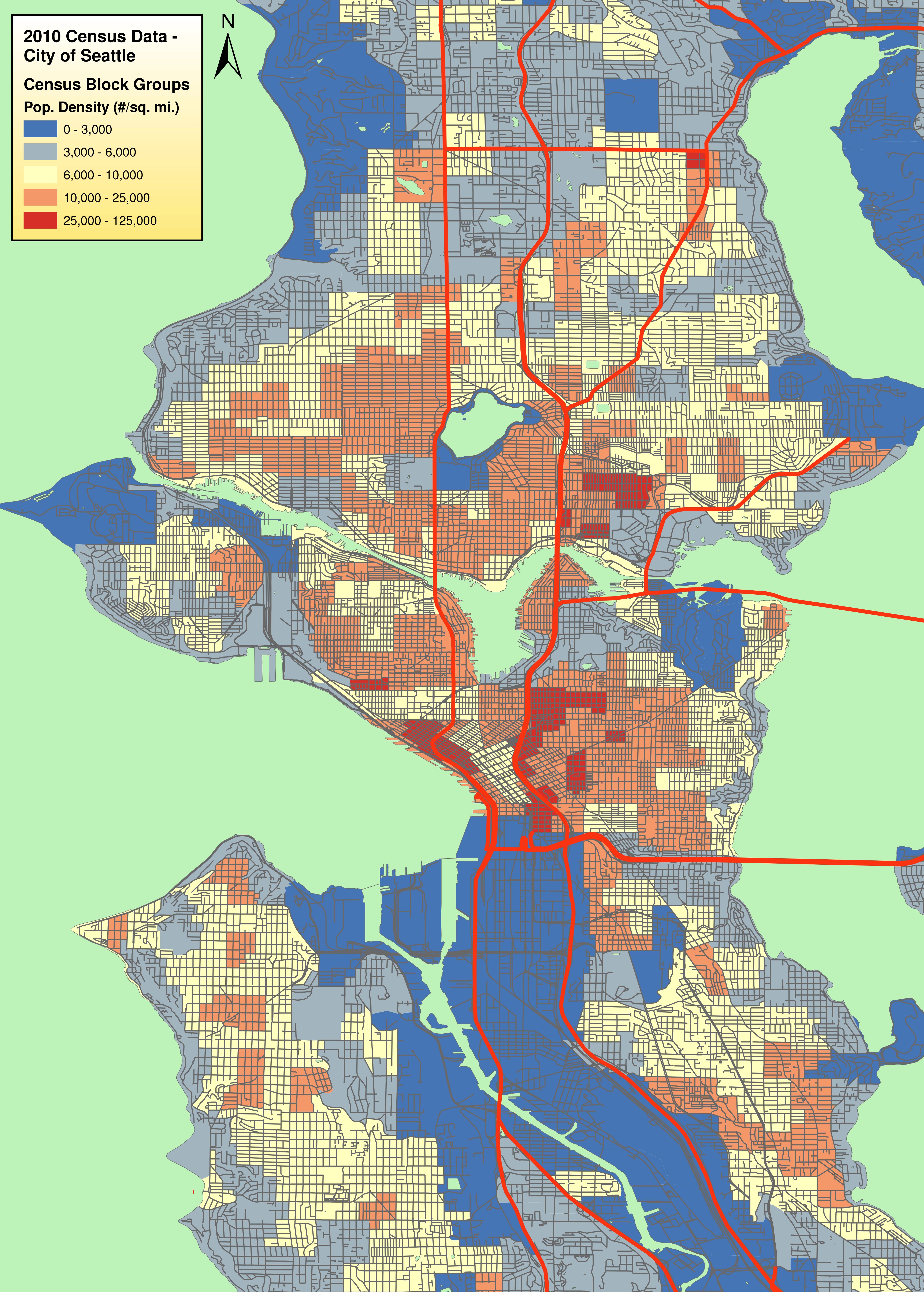
The density map of Seattle gives us a good picture of where West Seattle’s greatest residential density is. There is no high residential density anywhere on the peninsula. From north to south, we see pockets of moderate density in the Admiral District, western Alki, Alaska Junction, Morgan Junction, High Point, and White Center. If the map continued further south, we’d also see one more pocket toward the south end of Ambaum Boulevard. Under current plans, there will soon be another pocket of moderate density in the “Triangle.” Each of these is a logical place to at least consider an HCT stop. To this list, we can add a few major non-residential destinations: South Seattle Community College, the school complex with Chief Sealth High and Denny Middle in central Delridge (which I will conveniently but not quite accurately call “Roxhill”), the Fauntleroy ferry terminal, and Westwood Village. Let’s put these on a map and see what we get:

Uh-oh. That doesn’t look much like a rail line.
Maybe considering the second factor, current transit usage, will help narrow down which of these areas could be in a sensible corridor for major investment. For this purpose, we should be looking at the total number of daily riders a route serves, not at route productivity metrics. Metro, which operates all of the significant transit in West Seattle today, published these numbers in Appendix K of its 2013 Service Guidelines Report.
The Delridge/Ambaum corridor runs away with the crown for West Seattle’s highest transit usage, with 8,600 daily riders on route 120, well distributed throughout the corridor. Second place goes to RapidRide C (“route 673”), with 7,000 daily riders, the vast majority of which board at Morgan Junction, Alaska Junction, and Avalon Way. In a distant third place come routes 21 and 21 Express, with 4,800 daily riders between them, mostly from High Point and Avalon. Route 128 attracts 4,400 daily riders, but about half of those are from outside of West Seattle.
Bringing up the rear are routes that serve a few other points on our map. Ridership from Alki, Admiral, and South Seattle Community College is not negligible, but can’t compete with that from other areas. Ridership from the Fauntleroy ferry terminal is poor. So if we exclude those destinations, here’s what we get:

Now we’re talking. We can see a rail line taking shape in this map.
If we assume that substantially all 120, 21, and RapidRide C riders shift to the rail line, along with a significant number of new riders as the areas served add density and as fast rail generates more ridership, we could be attracting 35,000 to 40,000 daily riders with these stops. That’s more than Central Link currently serves, and enough to make a line at least intriguing. So how do we actually build a rail line to serve all these points?
Fighting the Topography
The central challenge confronting any project in West Seattle is topography. West Seattle is built on a series of dramatic hills, with neighborhoods largely separated by cliffs and ravines. All of this is separated by a sea-level river valley from the rest of Seattle.
The Triangle, Alaska Junction, Morgan Junction, and High Point are all at relatively high altitude — but are themselves separated by significant altitude changes. South Delridge and White Center are only slightly lower. Roads connecting many of these areas are steep and narrow. Except along Ambaum south of White Center, surface running is not an option. North of southern Delridge, elevated track or cut-and-cover tunnels are not an option either; the hills are just too steep. That leaves us with only a deep-bore tunnel option for the majority of the line, from a portal west of Youngstown to at least a point south of High Point, a distance of over five miles. (It’s possible that the mile or so under California Ave SW could be cut-and-cover, provided the trains can climb quickly enough from Youngstown.)
What’s worse, running elevated south of High Point isn’t easy either. To serve Westwood Village, the line would need to run elevated through a medium-density, lower-income residential area west of Delridge, a move fraught with environmental challenges (Longfellow Creek runs through the area) and certain to generate furious and justified neighborhood opposition.
The simplest option is the one depicted in my first map: to continue the deep-bore tunnel all the way to White Center, with a portal in the commercial portion of White Center leading to an elevated section along Ambaum Boulevard. The tunnel from Youngstown to White Center would be seven and a half miles long, longer than any single tunnel we have yet built in Seattle. This option would also allow fast and frequent connecting bus service to every other point west of the Duwamish.
And then there is the other topographical challenge presented by the project: a new Duwamish River crossing. Such a crossing would almost certainly be elevated, and would likely follow the current high-level West Seattle Bridge alignment very closely. An elevated bridge of that scale represents a major, and costly, engineering challenge of its own.
The Financial Challenge
Again, this assembly of a new Duwamish bridge, a seven-and-a-half mile deep-bore tunnel, and several more miles of elevated track might serve, by my very back-of-the-envelope estimate, 35,000 to 40,000 daily riders.
By comparison, the entirety of the combined U-Link and North Link tunnels is… about seven miles, and those two extensions are expected to serve nearly 100,000 daily riders combined, or more when Lynnwood Link is added. The proposed Fremont/Ballard “Option D” requires only about four miles of deep-bore tunneling for 30,000 daily riders (and that estimate is based on a revised Sound Transit ridership model which some of us feel to be overly conservative). The financial challenge of a West Seattle line is obvious, and not easy to reduce.
A “starter line” consisting of the Duwamish crossing and a short tunnel only to the Alaska Junction would abandon most of the potential ridership, and present serious social-equity issues. A Delridge-only elevated line would be much cheaper to build, but would similarly lose many potential riders — and would be cut off from the major sources of political power west of the Duwamish. A bifurcation of the line into Alaska Junction and Delridge portions would likely lead to unacceptably low frequency along both portions, and would harm mobility between destinations within West Seattle.
If we are going to bring good HCT to West Seattle, I believe there is no option but to bite the bullet and build a full line similar to the one I propose above, with all the expense it implies. Whether that is the best way for Seattle to spend capital dollars is a question we should all think through, and discuss, as the planning process for ST3 continues.
might I add …
if you’re gonna go all the way to the Burien Transit Center (or at least Burien) … why not extend it all the way to a junction near TIBS to connect to the SeaTac station track (and points south)
Would provide Airport access to West Seattle as well as an alternative route to SeaTac from downtown as well as Fremont and Ballard if connected to that downtown tunnel
I don’t think there’s any reason it wouldn’t.
Yeah, kind of a logical extension of the corridor. I think the dots after Burien in map sort of suggest that.
There’s a good chance it would be through-routed with the Burien-Renton line, so it would depend on where that line goes. I assumed it would go through TIB rather than SeaTac. We can’t bypass Southcenter again, and Burien, TIB, and Southcenter are all in a straight line on 154th.
If it goes south to SeaTac and then north to Southcenter, it would have the following obstacles: the length of the line, permission from the Port if it requires new track, new platforms or share the same platforms?, a sharp turn right if it’s sharing the platforms, impact to the hotel east of the station (the one that’s standing in the way of a SeaTac civic center development, although the track would impact that too), the residential area east of the station (176th, 170th, or 164th NIMBYs), the high ridge of I-5, and coming north from 176th to 164th to reach the denser area close to the current Southcenter bus stops.
In the fractured manner of ST long-range planning, Burien to Renton is being considered as a separate corridor.
That’s just to break up the study areas. Each segment has different residents, different desired destinations, different ridership levels, and a different gap level between their needs and existing transit. These studies give a preliminary estimate of where rapid transit can serve those residents, and at what potential alignments and costs. Later when ST forwards a concrete project to the ballot, it make combine some of these study areas into one line, and probably will, because one long line is more efficient than two short lines, and it doesn’t have the problems that long bus lines face (i.e., traffic congestion). The New York subways go from east Queens through Manhattan and back to east Brooklyn (a 2-hour trip) without batting an eye.
The south line here should have the capability of reaching Seatac Airport; it just makes sense. Keep in mind that our line likely will be eyed to also act as Tacoma’s method of linking to Seattle even longer term.
I still personally think there should also be a stop at Southcenter Mall, as well that both lines could access. It’s the largest single retail space in the entire Pacific Northwest.
Joe, I agree with both things. I can’t speak for David, but I think it likely he was considering what the North King subarea would pay for.
I should have made that clearer in the post. I’m focused on the same corridor ST has put in the LRP, which is very vague, but which they describe as “Downtown-West Seattle-Burien.”
I agree that if we’re building this much rail an extra 2 miles to TIBS makes a lot of sense. (The airport is a bigger challenge.)
Awesome post.
I want to say, I have a specific map much like this one. The reason Seattle Subway wasn’t specific was that when you go to the ballot, being too specific tends to hurt you more than help you, so setting up expectation of a very specific line too early can end up losing you support if something has to change.
Fair enough. Really, the only issue I have with the Seattle Subway map is the inclusion of Fauntleroy, which is a technically difficult place to put a rail stop and wouldn’t generate enough ridership to justify the difficulty. I think having it in there sets up unrealistic expectations. I’m 100% on board with the rest.
I’m curious about your ridership numbers at the Fauntleroy terminal. Do they include through riders on the 118 and 119?
If there were a subway station at Fauntleroy, it would be entirely reasonable to truncate the Seattle portions of the 118 and 119 and force a transfer. The 116 could also be deleted.
I’m curious about your ridership numbers at the Fauntleroy terminal. Do they include through riders on the 118 and 119?
Yes. The 118 and 119 have, to a fair approximation, zero daily riders. The 116 only adds a few hundred. Ridership from the area is really very low.
I agree. High Point is a much better source of ridership than Fauntleroy Ferry. Rapid Ride serves Fauntleroy due to the configuration of the road system and the historic 54 route. Grade-separated rail doesn’t have those considerations, and should serve High Point instead.
Moreover, much of the ridership from that area, and all the regional connectivity provided by serving that area, comes from the ferry itself, which has an uneven schedule of mostly 20-30 minute headways. Those riders would be served almost as well by a timed connecting shuttle that just ran nonstop to a connecting HCT transfer point as by spending the gigabucks to extend HCT to the ferry. This is how Translink gets people between Vancouver and the Tsawassen ferries. Route 620 buses wait for the ferry and shuttle passengers nonstop to Bridgeport Skytrain station, and vice versa.
Fauntleroy should not be included. Minimal density, and it seems logical that at some point (still decades away, I’m sure) ferry service from Fauntleroy will end and be transfered to downtown.
As far as I’m aware the Fauntleroy folks have long preferred the change of service to downtown or to Harbor Island. The one important consideration with Vashon ferry riders is not all of them head to downtown. A number work in West Seattle or points south. Many ride over for shopping and groceries.
I am not surprised by the low ridership numbers for buses servicing the Fauntleroy ferry, when I lived in Port Orchard I never even once considered taking transit over the ferries. I took the Fauntleroy ferry once and that was enough to convince me that I should never take it again. Its a really odd triangle route with odd loading patterns… it made for a very long wait and a very slow ride.
The hour long Seattle – Bremerton ferry was always faster for whatever I was trying to do.
Although, without a more specific route, it becomes difficult to put together decent cost estimates, solid engineering, and the entire line becomes subject to meddling politics because nobody decided on anything specific ahead of time. Then, come time for opening, the budged has exploded and the trains are much slower since it wanders over there then back over here.
Great article! I think the development capacity along this line is likely as good or better than any other current LRT project. Bel-Red, Northgate and Lynnwood will all blossom, but the latter two are hard against I-5. The Triangle, White Center, and especially Burien could accommodate amazing transit-centered growth. Go check out around downtown Burien sometime. Land of opportunity, perfectly situated.
That sounded a bit boosterish. I mean to say that there’s more potential ridership than meets the eye. As compared to, say, Ballard, which has already seen it’s building boom.
Boost away!
The best way to make the financial case for this expensive rail line look better is to improve the potential ridership numbers. The best way to improve the potential ridership numbers is to increase residential and commercial density. And the best way to increase density is for West Seattle residents who want rail to convince their neighbors that more density is good for the area.
I don’t live in West Seattle, but I have a close relative who lives there and spend a fair amount of time there. I’d love to see it start to live up to its potential.
Boost as much as you can! Thats how all this happens!
Yeah, nothing wrong with boosting. I think David is right. The more you push density as the way to solution to the traffic problem, rather than the cause of it, the better.
There is obviously a lot of potential in West Seattle and I’ve seen some big cranes in the last few years. But I think there are plenty of other areas in Seattle that will grow very fast, too — probably faster. For example:
1) Ballard. They aren’t done yet. Growth will spread west, towards Fremont. In a few years I expect most of the Leary corridor to be filled with big apartment buildings. More to the point, they are so ahead of areas like West Seattle that they could take five years off and build nothing but still have way more density.
2) Lake City. It is experiencing a big boom and this will continue. If you look at Lake City from the air you see parking lots and big buildings. The parking lots are being converted to big buildings as we speak. Even without the new buildings, in 2010 it was the only high density area north of the ship canal, other than the U-District (as shown by that density map).
3) Aurora Corridor. Aurora has slowly been cleaning itself up. The motels are being converted to apartment buildings. Close to where I work, I’ve seen three new buildings (from about 40th to 43rd) being built. I expect this to accelerate soon.
4) Greater South Lake Union — The building boom north of downtown is not limited to the area directly south of Lake Union. It spills out on all sides. The Cascade Neighborhood (REI) is growing. To the west is where much of the growth continues. It is spreading to the southwest side of Lake Union, as well as further west, towards Uptown. In a few years, everything south of Roy, east of the Freeway and north of Denny will look completely different than it did twenty years ago.
The biggest advantage West Seattle has is political. People know that traffic on the bridge is absolutely horrible — and that there really isn’t an alternative in most cases. They can also look at a map and see similarities. If Ballard has rail, why shouldn’t West Seattle. It is just as far from the city and the rest of the rail system. Folks don’t necessarily read density maps and figure out where rail makes the most sense. That is why Capitol Hill gets only one station, and the U-District only two (the same number as Tukwila). This is why the system is so strung out, because folks believe they are getting more value that way (the more miles the better). Unfortunately for West Seattle, the miles to the peninsula have a very high price tag. Light rail north of Northgate will be fairly cheap (since it will travel in the freeway right of way and be above ground). But as David mentions, there is no way we can get quality light rail to West Seattle cheaply.
Yup. What RossB said.
Personally, my feeling is that the following corridors would generate more ridership per dollar in the immediate term than a West Seattle line:
1) Ballard-Fremont-Queen Anne-Downtown
2) Ballard-Fremont-Wallingford-UW
3) Downtown-SLU-Fremont-Phinney-Greenwood
4) Northgate-Lake City or Roosevelt-Lake City
The big advantage of the West Seattle line is that the Duwamish crossing is a giant obstacle to growth in a huge part of the city with lots of future potential. Solving that problem permanently would unlock so many possibilities. But it’s clearly, and definitely, a long-term play–and an expensive one.
For those keeping score, West Seattle is about 1/5th of Seattle’s total land mass the last time I checked, but that also did not include Harbor Island itself. In the very, very long term, once the Panamax canal expansion completes, I’ve read analysis that ports in our wider region will decline. The Port of Seattle I’ve read is already at around 50% of capacity from the 60s, 70s, and 80s. It’s not out of the realm of possibility for zoning changes to eventually creep into and around Harbor Island with West Seattle’s growing density gradually migrating down there by the time we’re senior citizens.
Part of the reason ridership is low from the Admiral neighborhood is that bus service isn’t as frequent or convenient there as from the Alaska Junction. We are a family that’s considering a move from Admiral to either Alaska or Morgan to take advantage of easier bus and possible future light rail service. We would prefer to stay in our micro-neighborhood if we thought there was a chance of better transit there.
While I understand the reasons for including both the Triangle and Alaska Junction stops, is it wise to have 2 deep stations only a half mile apart?
Topography and massive deathroad. Yes.
I dont have a definitive argument either way, but I’d say yes, built them. If it is the best way to reach the people in West Seattle, then it is what ST should build.
Consider straightening the map out between the Duwamish and Alaska Junction. Might as well pop out of the hillside at Marginal & Idaho (at elev ~100′) to get a better start at the high crossing and more favorable track geometry for faster speeds. Any curve, and it looks like there would be many tight ones, means trains will forever travel slowly*. With the move, it could combine the Triangle and Youngstown stations into a shallow tunnel station (possibly at Gennesee & Delridge). That revised station and an AJ station’s 0.5 mile walkshed would nearly overlap. Another possibility is moving the Triangle Station to the Avalon & 35th vicinity with some underground ped tunnels.
Additionally, building a station of any kind requires about 500′ to 1000′ of tangent track (no vertical or horizontal curves). Putting an AJ and Triangle Station so close might not be possible due to geometry requirements.
Otherwise, I’m diggin it. When can we start?
*To give an example: the elevated curve from Delridge to the West Seattle Bridge alignment would look very similar to that curve south of Sodo Station on Link and we all know how fast the train moves there. My napkin calc gives a ~600′ radius curve on a significant grade, which would yield speeds of about 20-25mph.
“Additionally, building a station of any kind requires about 500′ to 1000′ of tangent track (no vertical or horizontal curves)”
I understand this is the current ST design criteria, but historically, factually, it is not true.
Yes, it is. Can you elaborate?
Both of those stations have 500′ of straight track available, and the curves are not too tight for ST’s LRVs, so they should be possible.
The issue with running underground in Youngstown (as you suggested in your first post) is that then you are facing very steep grades both to reach Alaska Junction and to cross the Duwamish at a high level. If you were able to zoom in, you’d see that I squeeze my elevated track into the narrow undeveloped space along the hillside south of the current West Seattle bridge. It would also be possible to build another short tunnel under Pigeon Point — but that would just add to the expense.
I think it’s unrealistic to expect riders to walk up or down Genesee to reach a station; that’s why I have both Youngstown and Triangle stations. I’d skip the Youngstown station except that it’s necessary to have reasonable connecting bus service.
It’s not too tight, but at what speed do you want trains to operate? Is 25-30mph from Alaska Junction to the Duwamish acceptable? The tight curves and close station stops means trains can’t get going too quick before they have to slow again.
Thinking of a Genesse & Delridge open-air tunnel station (similar to IDS and a plat elev of 48′), the grade from it to a 100′ mark on the hill would yield a 2.5% grade inside a tunnel. From there westward to a 60′ deep station (plat elev 253′) at AJ would require an approx 3.5% grade (~6000′ of running tunnel and a vertical gain of 205′). The bridge crossing would have a grade of about 3% as well. Nothing too shocking. Delridge buses could easily serve that station. And the benefit is no elevated structure. People like that.
Given that the Alaska Junction/Triangle/Youngstown troika will probably serve half the total ridership of the line, I’m OK with slightly slower average speeds through that segment if it allows us to place the stations right. The Youngstown station would be along Delridge just north of Genesee, and would serve the (small) local neighborhood but more importantly connecting bus service from both central Delridge and SSCC/Pigeon Point/16th SW. At full buildout, the Triangle station would have 10,000 or more people within its walkshed, almost all of whom would be separated from both Youngstown and Alaska Junction by large hills.
I also don’t know whether rail traveling up and down a 3.5% grade would be able to move significantly faster than rail going through gentle (and one sharp) curves. You certainly can’t hit 55 mph either up or down that sort of grade.
A train can hit 55mph on a 3.5% grade in general. It’s not that significant of a grade for a light rail train. And the curves as laid out are far from gentle. Anything lower than 2000′ radius requires a reduction in speed from 55mph. The alignment chosen at Pigeon Point will require something lower than a 1000′ radius curve to avoid property impacts, which slows the train to a top of 35. It’s safe to say the curve to the south of the Youngstown station would be 10-15mph. With the twists and turns and the added station stop, we could be talking a time increase of 2-3 minutes per trip.
How about this as a modification? Best of both worlds.
https://mapsengine.google.com/map/edit?mid=zacxSGDUglKM.k0erRg8OhEdY
Mike B, that tunnel under Pigeon Point is fantastic, provided we can squeeze it into the budget.
Fixed the link above, btw.
I was thinking about curves when I was looking at the route path around Morgan Junction in High Point. It seems that those curves could be eased by putting the Morgan Junction station a bit to the east and the High Point station a bit to the south.
In both cases, if you did that, you’d end up separating the station from the bulk of its riders by a significant hill. I think that should be avoided even at the cost of spending a few more seconds going through curves a bit slower. The only curve in this map that has to be taken really slowly is the one at Youngstown.
I know almost nothing the topography of West Seattle, so I should probably shut up, but…
Connect Triangle and Alaska in a straight line, with the platforms at Alaska Junction oriented ENE-WSW then curve to follow the street grid south until you’re NW of Morgan Junction and curve to the east and run the station platforms NW-SE. That should ease the curves north and south of the junctions.
BTW, what’s the turning radius of a TBM?
Mike B, what do you consider “… a significant grade”? Steel wheels on steel rail rarely climb more than a 6% grade.
Typically, more than 4%. Power requirements go way up, wheel slip becomes a concern, different rail is usually used, maintenance increases, speed goes down. The more flat, the better.
What is the asumption as to how this line gets to downtown? Uses exclusive ROW on the west seattle bridge and an elevated line north on first ave to a tunnel somewhere in north SODO?
I’ll cover that in a later post. My elevated line would actually run alongside 99 — it’s faster, simpler, and shorter. I’d get to 1st at the stadiums (where I’d put a stop) and then dive into a tunnel north of the stadiums.
Just one sodo stop? I was thinking of 1st ave stops at lander (starbucks, etc), holgate (assuming an arena gets built) and king.
If this is going to use bored tunnels, why not just continue the bored tunnels under the port area to sodo and downtown? Area is mush and fill, but bridge would have to be built on that too, so not avoiding anything. And sticking to tunnels might actually be more efficient than having more than two tbm access pits.
Also leads to the obvious question of how this might be linked to the Ballard Line. The Ballard Line should keep its tbm’s going all the way through downtown to a more convenient spot to put them in the ground again.
And what is with the huge stations? 500′ is insane. A subway car is 65 feet long. Four of them (as many as West Seattle is ever going to need) is 260. Plus some electrical/mechanical rooms, emergency exits etc, but there is no way to bring a station up to 500′ in any kind of logical fashion. And actually West Seattle would be fine with three subway cars. At 200 people per car, 30 trainsets an hour at peak, that is 18,000 people per direction per hour. Actually I’m talking myself into two-car trainsets, 12,000 people per direction per hour at peak. That is a station box 130′ long plus the various mechanical access issues. (Caveat: if connected to Ballard Line, better to go with three-car trainsets as that side of the line could have more demand.)
Faster, simpler, and shorter, but misses potential around Lander.
First Avenue.
The problem with any tunnel south of Jackson is that the new building at Occidental South and King has cut off potential use of Occidental without under-running it (and I doubt that it’s foundation was built with a tunnel in mind…..). It also has fairly stringently limited access from 2nd South by requiring a pretty tight “S” bend to pass south of the building in order to get over to Occidental or First.
And of course, there are plans for a clone of the King-facing building just to the south between it and the stadium. That will completely cut Second South off from access to and from the west to the north of the stadiums.
I expect that the south end of the Ballard-Downtown tunnel will have to go straight under Second Avenue Extension South, passing under the BNSF tracks and surfacing between IDS and Stadium. Whether it then shares trackage with Central Link or uses parallel trackage replacing the busway remains to be discussed.
One track could fit between the stadiums and the existing BNSF tracks, so maybe one surface track and a one-way tunnel past the stadiums would work if the east half of the parking lot south of King can be preserved. At least then you’d be on the proper side of the BNSF tracks and might swing over to First Avenue along Holgate. But of course that means the surface track and the tunnel under it would have to thread through the moving roof supports at Safeco.
If that worked there could be an event station just north of Royal Brougham which would be a very good “Stadium Station”. Folks using Central Link would be jealous.
Likely an elevated line along First, then connecting to the Ballard-to-Downtown line, so it would match whatever that line decides to use (2nd Ave Tunnel or a couplet of some sort) in Sodo.
Could this portion of the line stop at both Starbucks HQ and directly in front of a new Sonics Arena? That destination alone may help justify the ridership projections for the entire line if Seattle ends up with both an NBA and NHL team in 15 years.
Knowing the politics of transit in this city, I could envision the sticker shock of a new Duwamish crossing totally sandbagging the project—People who pushed Link initially and opposed the West Seattle to Ballard monorail will tell West Seattlites that more frequent Rapid Ride will be our salvation. Possibly prevaricate another 10 years or so before another study is done on the readyness of West Seattle for Link.
Maybe the metro budget cuts that take effect in the summer? of 2014 will tie up traffic around the city to the point that the pols as well as the public will be amenable to ambitious transit spending plans.
It’s really a matter of whether it goes into ST3, ST4, or some city measure after ST3. Sound Transit has to choose a common tax rate across all the subareas for ST3, so it has to balance what each subarea wants vs how much tax it can tolerate. Once it decides on a rate, that will determine whether Seattle can build one line, two lines, or three lines in ST3. Then it’ll have to rank the lines by priority. We’re assuming Ballard-downtown is #1, but then it’s up in the air whether 45th or West Seattle would #2. (ST’s long-range plan also has Bothell LR and Aurora BRT, but those are not being studied for ST3.)
45th clearly has more potential in terms of ridership and need, but it has the disadvantage of a potentially messy transfer in the U-District (due to space constraints and lack of ST planning at U-District Station). West Seattle’s advantages are more geographical coverage, influential political support, loud citizen supporters who could become more numerous, the ability to through-route a Ballard-downtown-West Seattle-Burien-Renton line, and better usage of a second DSTT.
What exactly is the messy transfer at the U-District station? Would it be better if it connected via the Husky Stadium station?
I ask because one possibility is to have the Ballard to UW route go via Fremont (instead of 45th). This would send it fairly far south. While I think connecting at the U-District station would be better, it wouldn’t be that far to connect to the Husky Stadium station instead.
Politically, I think the best bet would be all three, but BRT to West Seattle. But you would have to make sure it is really good BRT, not the half ass BRT called RapidRide. Add stations, dig tunnels, build off ramps, the whole works. I think this comes in way less than 6 billion (maybe 2 at the most) and gives West Seattle riders a fast way to connect to the light rail (and it would be built sooner).
U-District station is constrained by UW Tower on the west, the historic Neptune building on the east, and a historic apartment building on the south. There’s only a few feet of buffer between the station box and the west/east constraints. ST should have made the station expandable at the beginning, with either a crosswise platform below or to the west or sharing the platform, but they didn’t, because the 45th alignment isn’t voter-approved yet and its alignment hasn’t been decided.
To me, it should have been obvious that this would be the biggest transfer point in north Seattle. You only have to look at the frequent 71/72/73 and 44 and 70 to see that — Metro has clearly considered it critical for decades.
The 45th alignment will doubtlessly include Wallingford. The question is whether it will zig down to Fremont and zag back up to Wallingford — which it could do underground. I don’t see it likely going on 40th or Pacific Street. If it shares UW station, that would probably be more tricky to engineer, plus more construction in the most auto-congested area, and it would be far from the all-day ridership on University Way. Plus it would cross more UW land so the UW would have to give permission.
What I’m concerned about is, I could see ridership dropping by half if the transfer is inconvenient. If it’s easy to transfer from Wallingford or Ballard to Capitol Hill or Roosevelt or Northgate or downtown, people will. If it’s not, they’ll take their existing buses or drive. The worst scenario is an underground station a block away, that requires people to come up to the surface, wait for a stoplight, cross a street, and go back down to the other station.
Regarding really good BRT for West Seattle, it would have to come down to building a separate stand alone lane (bridge?) that is not shared with cars in any way shape or form. There is a stretches of a bus only lane on the bridge and on 99N, but no HOV lanes otherwise. If the lane is an add on to the WS Bridge, it would potentially be a very tight fit and you may have conflicts/problems with the 4th Ave S exit going Eastbound.
A separate bridge may solve the problem, if you can effectively fight the political sticker shock battle.
@Mike – I agree completely with regards to a transfer. The transfer should be completely underground, and should be easy. It it the key transfer for the entire north end. The UW is a big destination by itself (much bigger than all of West Seattle by the way) but the transfer location just makes sense. As the crow flies, going from Ballard to downtown via the UW is not that bad. Coming from the north end, it is the logical transfer point. Since the UW is probably the second biggest destination in the state, it makes sense to transfer there. Let’s hope they can pull that off.
As far as the inevitability of Wallingford, I don’t agree. 45th is a major corridor; but we aren’t serving corridors. We are serving individual stations, spread widely apart. Taken in this context, it is hard to see how 45th is such a great route. If a UW to Ballard line was built with quarter mile stations, I might vote for 45th — but with the type of stations we like to build, I think a southern route just makes mores sense. Stone Way is a nice spot and so is Aurora. That gives you two spots close together when Sound Transit would rather build one. Even if both are built, I would argue that a station at Fremont and Eastlake/Campus Parkway would be better. Stone Way is a major corridor as well, but you can funnel people from there into Fremont without too much trouble. Folks on Aurora can walk down from a bus stop on top of the troll. Meanwhile, Eastlake/Campus Parkway is way more dense than anything in Wallingford or Fremont. It is part of the UW, but set aside from the other two stations. Given its density and popularity, it makes sense for the UW to have three stations. But the big bonus of a station at Eastlake is that it serves the Eastlake neighborhood. Now the folks who will probably have to wait years for their own light rail at least have a fast bus connection to a station, instead of slogging through UW traffic. Of course, a lot of it depends on how expensive it is. A southern route could be cut and cover or maybe even elevated — I don’t see that as possible with 45th.
@East Coast Cynic – Yes, absolutely correct. It would be expensive, but nowhere near as expensive as what is proposed in this post. Basically, instead of starting from scratch, you add a lane here, a ramp there, a transit station there, etc. The nice thing is that a lot of the work is already done. The other nice thing is that it actually makes sense for the area (given the expected volume). I mention this below (https://seattletransitblog.wpcomstaging.com/2013/12/27/how-might-west-seattle-link-actually-look/#comment-402131) as well as here: https://seattletransitblog.wpcomstaging.com/2013/12/05/news-roundup-63/#comment-392436
I’m assuming it would have closer stop spacing than Central Link, since it’s not the main north-south trunk. Something like U-District, Latona, Wallingford, Aurora (46th), Fremont (34th), 8th NW, 17th NW. DP has a good map somewhere.
I don’t know how hard it will be to sell. I really don’t. I know I’m willing to try it though. After having talked to many many people in the city about it, a common theme I’ve gotten from them is that they want some kind of final solution. They want a light at the end of the tunnel, a for-sure way of getting around. I think if that is what we’re selling, as a convenience for now and a investment in the future, we will do ok.
I honestly doubt this. Yes, it will be expensive, but West Seattle has frothing at the mouth to get more capacity, especially transit capacity, over the Duwamish river for ages now. A big, shiny, high profile, bridge from Sodo to West Seattle is exactly the kind of thing that could serve to be a unifying symbol of the project. A nice, big, obvious, tangible piece of expensive infrastructure that people can look at and say “we want that”.
Also, this project goes far outside the city. The line would cross city limits at Roxbury, and Burienites who already feel like they’ve been getting the short end of the transit infrastructure stick would support this.
Your advice to ‘bite the bullet’ is quite a mouthful. At todays prices for tunnels, stations, and elevated you’re talking 4-5 Bil for maybe 40,000 daily riders, or an 1/8 mil investment for each.
I guess Auburn will have to wait for ST5 for their 2nd garage in 2060.
Stop trolling about Auburn and Renton false inequity meme. It’s obnoxious and simply not true.
“Seattle Transit Elite clashes with Auburn Transit Trash”. film at 11.
^^Wow, that’s cute mic!
MIC, I’m from Kent, get your story straight. While I may now live in Seattle, I actually give a shit about SE KC. It’s not at all how you portray the situation at all. I used to be a transit rider through Kent and Renton all the f’ing time. I know what I’m talking about.
Auburn will have to compete with whatever else South King wants. Tukwila is eager for a Burien-Renton line serving Southcenter (as is Renton in East King). Federal Way is eager for a south Link extension (as is Tacoma). Kent has the most critical transit needs, which would argue for more Sounder or a north-south express, and possibly an east-west route to Kent-Des Moines station. So Auburn’s garage will have to be prioritized among those.
And I’m hoping that ST and Auburn will agree on a public-private partnership that deals with the parking and enhances pedestrian circulation and destinations in the station area, rather than detracting from them. They’ve made a start with the first garage, which has a couple retail spaces on the ground floor (IIRC a cafe and a college extension office). Auburn just needs to build on that to make it a better pedestrian environment, and more destinations and housing in the area.
By the way, note the pattern of some projects benefiting multiple subareas; i.e., Renton and Federal Way. That will probably carry a lot of weight in the negotiations.
Light Rail should primarily be installed to relieve the bus system from having to run too many vehicles to carry the loads along extremely busy corridors.
From Alaska Junction and everything south of that, just look to the ST560 route for your justification to build light rail. The 560 is a joke route, demanded by Nickels to show he ‘got something for W.Seattle’ as their homey. It carries very little and doesn’t run very often
Suggesting to keep running expensive rail along that route to Burien, then Seatac, then (Aw, shucks, let’s go to Renton too), just shows how fiscally naive most commenters are here on STB.
Never mind that the Seattle sub-area ends at White Center, so all this extra cost (1-2 Bil) to Burien, is on S.Sub Areas dime, which is a convenient way for Seattle to keep the needed improvements in S.King from ever happening and solicit a partner in their funding and operating cost scheme forever. BTW, why doesn’t Seattle pay a dime for the 560, the 550, the…?
Try reading some local newspapers sometime, and you get a diferent take on how the burbs are dealt with from Union Station (http://www.auburn-reporter.com/news/104427919.html)
I’ve worked with Mayor Lewis for years, and if he said Joni said it, you can take it to the bank.
mic, you might have noticed this other bus route that runs in the corridor you’re complaining about. It’s called the 120, and it’s the busiest bus route in West Seattle and the sixth-busiest in the entire county. The 560 is too infrequent and limited to be of much use.
Fair enough, but 21 am trips in the peak (6-9), with half a load between Burien and White Center is hardly screaming out for LRT. Going from 175 riders per hour in that segment within S.Sub Area to 18,000 pphpd seems like buying 747’s to replace all the Cessna 150’s flying around.
S. King has many other priorities other than being a good neighbor to facilitate W.Seattles ‘Rail Envy”.
If you buy $100 worth of goods but you only pay $75, you only get $75 worth of goods. That’s why Auburn’s parking garage was suspended. Where do you think the other $25 will come from?
It’s not “rail envy”, it’s using a mode that’s immune to traffic bottlenecks, has more capacity, and is more likely to be scheduled frequently. Having a train (or a bus) coming every 10 minutes until 10pm is an exponential leap of mobility and freedom compared to a bus that comes every 15 minutes daytime, 30 minutes early evening and Sundays, and 60 minutes late evening. If Burien doesn’t want it as much as West Seattle does, well, that would be good to know.
Why don’t you tell us what you do want in Burien, Renton, West Seattle, and elsewhere, rather than arguing about whether one subarea is getting more value for their dollar. The goal is to put the optimum level of transit everywhere, so what kind of transit do you think West Seattle needs and Burien needs?
Good question Mike. Let’s start with my earlier statement.
“Light Rail should primarily be installed to relieve the bus system from having to run too many vehicles to carry the loads along extremely busy corridors”.
Under that criteria, I seriously doubt there are ANY corridors in S.King County that would currently qualify. Certainly not the extension south of White Center to Burien, or from Burien to Renton. Seatac to Tacoma would also fail the test for highest HCT technology upgrades based on current ridership of RR-A, and anything traveling north from Tacoma except during the peak of the peaks.
Now, if money were no object, then of course, ‘Build Everything Now’ makes entire sense to accomplish your goals of eliminating all bottlenecks, having great capacity (ie replacing all C150’s w/ B747’s), and great frequency throughout the day. The fact that trains running with skeleton loads becomes a moot point. The icon for ST could then become Alfred E. Newman captioned “What, Me Worry?”
I would enhance Commuter Rail to an all day proposition by moving many more freights over to an expanded (double tracked) UP line to Tacoma yards, and purchasing enough 24/7 slots from BN to do it with CR, RDC’s or whatever makes sense. I would build real BRT along 99. 5, 405 and 509 to move the masses where they want to go, without breaking the bank, and I would quit cannibalizing Metro to feed the LRT beast, as the tax dollar knows no destination, just that it got collected.
Oh, and I would build the second garage in Auburn, as promised.
I’m excited by this conversation for LRT tunnels because it 1) provides rapid, reliable schedules avoiding car congestion, 2) allows scaling the vehicles’ capacity without adding drivers, the highest operating cost factor, and 3) intrudes less into neighborhoods.
Perhaps a list of compelling reasons for this plan could be compiled for elevator talks?
hmmm thats a great idea! Im not sure that I’m the person to do it, but here’s my try.
1) GREATLY reduced travel times
2) environmentally responsible
3) great investment for the future, capital cost are high to be sure, but operating costs aren’t, and trains very rarely need to be replaced(like every 70 years)
4) allows new residents in West Seattle’s growth area to go carless
5) ummm anyone else want to jump in here?
A more ideal transit authority would provide both the buses and LRT. What if the “C” is scaled back with operating funds applied to LRT? Unfortunately funds don’t transfer very easily unless one subsidizes the other which is problematical. The METRO service cutbacks will eliminate many circulator routes around the peninsula: perhaps the “C” productivity can be cannibalized to restore circulator routes.
What about building a ‘hub’ near the stadiums or Starbucks HQ to link with the buses serving downtown and from downtown to other urban hubs?
Why not address the social equity issues by crossing the Duwamish at the new South Park bridge, instead of at west seattle bridge. then loop north through white center to end at the Triangle? No high bridge needed, no boat traffic.
That lets you pick up Georgtown as a by the way.
Relevant to the route map above, if the High Point site moves east to 35th, the hills look much more straightforward, at least on a google map.
It isn’t clear to my why any route would need to be tunneled along California.
Because we’d put a second N-S line through the Duwamish to serve Georgetown and South Park.
Ben,
Much cheaper to have a tee in south park where the the airport express/west seattle line split.
California Ave is too narrow for bike lanes, let alone two reserved lanes for at-grade rail. Also, mid-rise apartments are built right up to the sidewalk on both sides of the street in some places, to make elevated undesirable.
chad,
appears to be three lanes, with two additional for parking.
can’t comment on the no room for bike lanes – seems like that’d depend on the neighborhood council – but that certainly seems like plenty of room for whatever transit is funded.
Ben: the U through south park also allows future extension up California to Admiral, should the residents ever allow more density.
California is very narrow. I can’t even imagine the chaos and uproar it may cause if you wanted to plop a surface grade dedicated pair of rail lanes into the middle of it. Speaking personally, during certain times of the day, driving up California is a damn chore already.
Because that would cut off Burien, which is the only officially designated Regional growth center on the proposed line.
Is the ridership potential really that low from Alki & North Admiral? I’m not from or clam to know much about west seattle however given the “lack of transit coverage” in west seattle I think we should be a careful basing future coverage on current ridership. Last I checked Alki & North Admiral had rather poor bus service which might be causing poor ridership. Additionally aren’t those high tourist areas? How can we capture that and take it in to account?
It’d be interesting to see this on a topography map so those of us with less knowledge of the area can understand why some stops are so close.
Admiral and Alki, for many years, had half-hourly all-day service to downtown along a very straight and fast route (the old 56). That service was always underused, to the extent where Metro reallocated some of its resources to RR C and the 120. I’m sure rail to those areas would improve on historical 56 ridership, but I don’t think ridership there could compare to ridership from the areas I included in the line.
In my perfect world, there would be frequent bus service to both Admiral and Alki from both the Alaska Junction station and the Sodo station on Central Link. Have a look at routes 50, 51, 52, and 53 in my “dream network” proposal — none of them would be different if this rail line were built.
That’s interesting information about the Route 56. However, I’m interested in how plausible, engineering and port interest wise, would it be to build the bridge west from Lander Street in SODO over Harbor Island, which would directly serve Admiral junction? I’m not sure if that’s a better routing than what you proposed, but it seems it should at least be considered, given that the Admiral district is fairly dense and that connecting to Lander Street station would be very easy to do with this approach.
Alex,
Have you taken a look at the cranes on Harbor Island? Take another. They’re nearly ten stories high.
So, “No, it isn’t a good idea to cross Harbor Island with a transit bridge.”
So what that they are ten stories high? Any non-draw bridge would have to be at least about 120′ high for ship clearance and the west side of the bridge could easily be built much higher considering that the tunnel portal from the admiral district could be as high 280′. And that’s before considering that cranes don’t cover the entire island.
There are cranes on both sides of the island, so effectively they do cover the entire island. And there is the large area west of the main channel over which you’d need to build supports as well in order to avoid a roller-coaster dip.
You’d have more than a half mile of full height span (> 150′) rather than just one “hump” like the current bridge. It would be enormously costly and for what? To serve the few thousand people around Admiral and California? It’s massive overkill.
Alright that makes reasonable sense. I only thought it would be a good idea if they were similar cost projections and I was unsure why specifically it would particularly costly. That’s why I asked the question.
I’m trying to understand the logic of relatively close together multiple tunnel stations in a low to medium density area, when Capitol Hill, with ten times the density of West Seattle, gets just one station.
I would have put three stations in Capitol Hill: Pine/Bellevue, the one that did get built at Broadway, and 15th E.
+1
I agree.
I love you for saying this!
Seriously. Might as well fill the West Seattle route with stations every two blocks, because we know how Sound Transit loves to omit stations where they’re sorely needed.
Speaking of, is there any information about the feasibility of building an infill station near 14th and Aloha?
ST has its hands quite full now so I doubt it has looked at the cost of a 15th or Summit infill stations. First we have to get Graham Station done; that’s low-hanging fruit. Infilling underground stations would cost “a lot”; we know that much. There’s too much pressure for Ballard and 45th lines to add any Capitol Hill stations before those lines are funded.
Is there 500ft of straight, flat track near Summit Ave? I wish I had detailed track diagrams of that curve; ST was quite unwilling to consider building the downtown Bellevue station on a curve, but that would have been the equivalent of building the station at the elbow of the U-Link helix.
Just think, if we build an infill station at Boren and Summit, we could avoid the entire FHSC boondoggle. A man can dream, I guess.
Bellevue & Pine is where the ridership is. It would be used by north Summit riders up to about Harrison (after that Capitol Hill station is closer), by Pike-Pine riders, and by First Hill riders on the near side of the hill. Summit Avenue does not cross Boren Avenue anywhere, so I assume you mean a station around Boren & Madison. That’s essentially the same as the First Hill Station that ST chopped off, so it had no chance.
I really wish we could have had a First Hill Trolleybus BRT instead of the First Hill Streetcar. That would have assuaged ST’s concerns about First Hill station, and saved money that could have gone to something else, and made it more frequent, and allow it to be extended into something that could replace a bus route or two.
My understanding is that the Central Link alignment crosses 15th Ave around Highland Drive — not exactly a great place for an infill station.
At this point, I think the right way to serve Summit and 15th is with a crosstown subway (i.e. the 8 in train form). I know that’s not in the cards right now, but maybe ST4…
The FHS fiasco shows what happens if we let unknowledgable people lead the day. It basically happened because First Hill activists said, “We want rail! Capitol Hill is getting rail, and they’re our rival so we want it too! We’ll accept nothing less than a streetcar!” So the idea of Broadway BRT wasn’t even considered. The reason ST didn’t consider it is it didn’t want to say no to a politically powerful neighborhood that had been promised rail. The reason the First Hill activists didn’t consider it is they were afraid it would be watered down to the existing trolleybus service levels: 30 minutes in the evening (as the 9-local was), or maybe not at all (the 9-local was deleted several years ago), and slow (insufficient priority). If ST had proposed a really good trolleybus line, and convinced First Hill activists that it wouldn’t be watered down, then maybe it could have happened.
I don’t know the exact profile between Broadway and the Ship Canal undercrossing, but I would bet that the ST engineers have a pretty constant gradient between those points, in order to minimize the steepness and make the tunneling task as straightforward as possible. Curves (in any plane) are more difficult for the TBM.
A station requires over three hundred feet of flat track and it just is not there in the tunnel.
There will be no infill stations.
Capitol Hill deserves about 1-2 minute headways between link trains at their single station given their density.
My answer to your question is that transit advocates have become bolder. We’re finally ready to ask for what we actually want, and fight to make it happen. We can’t change the past and make it perfect, but we can fight and advocate for the best transit possible in the future. Want to join us?
More like transit activists have become more knowledgable, and have formed more of a community to share ideas and reinforce each other’s opinions. Remember, STB only got started to defend Roads and Transit. Neither of the stations David suggests were even considered at the time, and most people might have laughed at a Pine/Summit station, though not as much as the weird, bendy curves required to serve First Hill. Neither would Metro have even considered eliminating any one-seat rides to downtown, let alone any independent advocate, and the idea that buses might be superior to rail in any way in any situation, that BRT might be more than a way to kill rail, remained equally unthinkable until this blog became enamored with Jarrett Walker. ST itself remained a PR disaster until the monorail screwed up one too many times, and what transit activists did exist only publicly wanted a cool toy to play with, or to “reduce congestion” or save the environment – density was not spoken of and TOD was completely unheard of.
Ben said it earlier, “Different lines at different times.” Capitol Hill was on the first Seattle line, which made it a different political environment; and it’s in the primary corridor between Everett and Tacoma, so end-to-end travel time is more of an issue. It’s possible to do things in a non-first, non-primary line that weren’t feasable before. You can’t expect the same standard to apply across all lines at all times, because that ignores the fact that different people are making the decisions, at different times, and at different stages of Link’s evolution and usage.
Thanks for looking into West Seattle rail! What you present is likely to be the best scenario for West Seattle light rail, and it is very similar to the line in my head.
However, another option should be studied, which may, unfortunately, be more practical: Elevated-streetcar hybrid, similar to the SF MUNI light rail lines or the Boston Green Line.
A grade-separated rail line would be built from downtown across the (existing) West Seattle bridge. (Seriously: with rail in place, the eastbound bus lane can be eliminated, and the other lanes&shoulders narrowed enough to fit 2 rail tracks) Upon reaching West Seattle, the line would separate into several at-grade streetcar routes. The “junctions” in West Seattle were originally streetcar junctions. There could be up to 5 streetcar routes eventually, but the recent bus restructure has consolidated downtown transit demand into 2-1/2 corridors: C, 120 and, to a lesser extent, the 21. It’s reasonable to built 2 streetcar routes: the 120 and C. Each of these could have 10 minute frequencies, for 5 minute frequency on the common segment to downtown.
I made a quick Google map of the concept
The downside is that the streetcar routes to White Center would be too slow to extend into a “grand circle route” to Burien, Sea-Tac, Renton, etc. But ST has been running the 560 along this corridor since 1999, and never seen significant ridership. I hate to say it, but there just isn’t much demand for express service (i.e. the 1-mile stop spacings typical of Link in the suburbs) between White Center and Sea-Tac. The transit demand is evenly spaced and linear, better suited to the 120 than the 560.
That sounds good, but I think you could accomplish the same thing with BRT. The big advantage of streetcars over BRT is that they can handle way more people. In this case, I don’t think this is an issues (as mentioned, the ridership isn’t that high).
Hi Chad, I think it would be short term thinking to turn the regional line into a streetcar line. I could definitely see an argument for a simplified express core route plus a streetcar (what First Hill/Capital Hill got) for cost effectiveness and increased coverage over West Seattle, but we don’t want to encumber a regional line with streetcar segments just because the area its going through does not currently have the growth to support it.
You would hamstring the line between Seattle and Burien by running it through the streets of West Seattle. If you can keep it fast and grade separated the whole way, you would have a lot more people willing to consider using a bus to transfer to it instead of just hopping in their cars.
If we can afford to go big, I am cool with going big (though let’s avoid unnecessary 90 degree turns, right guys?). If we can’t I think the regional nature of the line (with space for in fill stations) would be a much better option than trying to get maximum coverage by putting streetcars instead.
There are infantt routes and limited transit dollars. The core spine from Everett to Tacoma will be fund before any of the rest of this. Every area wants light rail in a tunnel. The cost vs readership is not fair to the region . To have one area act like they deserve a tunnel and use up so much of the money at the expense of whole system is wrong. Growth and density equals high ridership. Most of west Seattle has fought and prevented up zones. They have fought the zone and density that they are getting now. A surface/elevated to Burien is all the region can afford now and more that west Seattle deserves from the region unless is accepts south lake union density levels which it would fight. A Streetcar to Connect the other major points to the light rail line to Buried is far cheaper and doable in our lifetimes.
This is all “do-able” if we make it so. I think we should aim high for all of Seattle’s neighborhoods, rather that fight over which one deserves more money than another. Please remember, if we don’t ask for money for West Seattle, the money “saved” doesn’t go to Ballard or some other place, it just stops being a part of the ST3 taxing authority. So we don’t get it ever, to spend on anything ever.
Basically, there is a time and place for compromise, but its not here or now.
“The core spine from Everett to Tacoma will be fund before any of the rest of this.”
It doesn’t work this way because of subarea equity and the 10-year lead time in building lines. The most critical and expensive part of Everett to Tacoma is already funded — Lynnwood to Kent-Des Moines. As you said, it came first more or less, although already East Link is being built in parallel. The rest of the extensions to Everett and Tacoma are outside of North King entirely, and almost outside King County, so we don’t have to worry about them. There’s still some question about whether the Everett and Tacoma extensions will be built at all [1], but assuming they are, they will definitely be in parallel with additional Seattle line(s) — subarea equity requires it.
[1] The arguments against the extensions are the long low-density segments, low ridership/cost ratio, the potential for BRT feeder alternatives, and the potential for streetcars and/or Swift lines within those counties. The arguments for it are, it’s what those subareas want, and if they don’t get it they may be less inclined to vote for ST3/4.
Excellent post. This is why I love this blog. You really can’t get analysis like this anywhere else.
I’ve been around West Seattle quite a bit, but still have a hard time getting a handle on it. It is a tricky area. Like you said, a lot of it is the geography (want a workout? walk up West Seattle hills). The density map is very helpful, but it only covers residential density. It doesn’t mention office density, or other areas that are daytime destinations. For West Seattle, there aren’t many, from what I can tell. My guess is the biggest one (my alma mater, by the way) is South Seattle Community College. Unlike the other community colleges, this route manages to skip it.
I just don’t see West Seattle being great for “direct home to destination rail”. In other words, unless you spend a lot of money, I don’t think you can make a system that allows people to walk directly to the train, or walk directly from the train to their destination. This proposal costs a bunch of money, but leaves out a lot of people. It misses several of the “orange blogs” in the density maps (areas of medium high density). But I agree, this is probably the best we can do, unless we want to spend even more money, and have several lines in West Seattle. I just don’t see that making sense.
I think the West Seattle line needs to be based on feeder stations, not dense locations in their own right. I’m thinking more 130th versus Capitol Hill or UW. This leads me to conclude that we have a couple choices:
1) A scaled down version that is mentioned in the second to the last paragraph. I would like to see that option explored more, but with feeder buses as the focus. The biggest gripe I hear from folks in West Seattle is not travel within West Seattle, but travel outside it. Can we add stations that allow for fast transfers? How would the bus lines change?
2) Real BRT. There are already existing car pool lanes on the bridge. How much would it cost to add more? How much would it cost to add new ramps so the BRT buses could have a completely grade separated ride from West Seattle to a train station. How about a small transit tunnel (that could be converted to a train tunnel) in West Seattle from the freeway to Alaska Junction? Is that justified, or is this area not really that congested. I throw out some ideas in this comment, and would love it someone at STB considers them in more depth.
David Lawson, picking up on your idea for a stop at the stadiums, why not have a minor hub to transfer to buses into / from downtown? That would reduce the load on the “C” line which will have very heavy ridership if the 2013 Metro cuts are still in place when this LRT is built. Perhaps SDOT and Metro will contribute to the ST operating costs?
What I get out of that Seattle density map is that West Seattle is not the prime area for new HCT. Queen Anne and Ballard, yes. But before a line through West Seattle gets built, how about an extension of the Ballard line north and east, connecting at Northgate? How about a spur line to Lake City, which has the only highest-density blocks on that map for which there are no plans to build HCT? Lake City in particular is set to become much more dense as the car lots turn into apartments. A plan for a subway to Lake City will accelerate that process and make the line even more worthwhile.
Don’t get me wrong, I want light rail to everywhere, but the next $7 billion line could serve denser neighborhoods than West Seattle.
ST is studying Ballard-downtown, Ballard-UW, and downtown-West Seattle-Burien for ST3. That pretty much means the others won’t be considered, because ST wouldn’t propose a line without having studied it. At most, the Ballard-downtown line might be extended toward Lake City, but not all the way to it.
“Spurs” are not in the cards until the Lynnwood Extension opens and ST sees how much capacity is actually available after a few years. It would run into the same problem as the Ballard spur idea, except that it would have less ridership to recommend it. Your best bet is to push for the Bothell-north Seattle segment, which could be a shuttle or be rolled into a Ballard extension. It could meet Central Link anywhere between 145th and Roosevelt.
To be fair, density in West Seattle is vastly increasing. You can’t read our local news on http://westseattleblog.com/ on any given day but to see reports of another new increase in density. Our current population (just city-side, not counting our county brothers just over the arbitrary line) is around 95,000. If you add in everyone from Alki south to Burien, it’s well over 120,000+ easily. The capacity for housing just keeps climbing, too, and shows no signs of slowing down. By the time light rail would be live for it’s inaugural ride (2025?) our housing capacity could be well over 150,000 down here. In today’s terms, that would be 23% of Seattle’s likely end of 2014 population (figure 640,000).
I’ve envisioned this line coming up the hill from Youngstown and having one station at Alaska/Fauntleroy (which is trending toward being the new center of the Junction area) before diving into the hill under Providence Mount St. Vincent to head southeast to the 35th/Morgan area. Not everyone needs to be able to walk to a station. In fact, I suggest that we force transfers from buses onto this rail system at the West Seattle stations and use some of the service hours saved to beef up the frequency to places like Admiral and SSCC. I know I’d gladly give up my current unpredictable one-seat ride for a more reliable two-seat trip.
Current density shouldn’t be the only driver for planning transit infrastructure like this. West Seattle generates more than 100,000 vehicle trips everyday on that choke-point called the West Seattle bridge, most of those trips going up to Ballard, the U-District, and across the lake to Bellevue and other points. A lot of these trip pairs could be well served by a line well-integrated into what is already being planned. A well-thought out and implemented feeder bus system could capture a substantial number of these trips.
We need more density in West Seattle. The demand is clearly there. One of the main limiting factors to West Seattle supporting more density is the lack of capacity in our current transportation system. Bring on the rail and jack-up the zoning around the stations. Is there someway the city can create a conditional overlay in the zoning code, that would kick-in higher density in an area if a fixed guideway transit station is built there?
This is a great post, David, and I’m glad there’s still someone at STB who does deep dives with real data, as I appear to no longer have the energy for it.
I feel like the alignment you’ve sketched out here is the Option D of West Seattle — it’s very expensive, very nice, and will serve its station areas extremely well, but in a world where money is not free, and other expensive transit projects (crosstown 45th/Market) are desperately needed, it may or may not be the best use of funds (even setting aside the question of whether the Duwamish/SODO segment of any such line would make it prohibitively expensive), if there were other options which could provide significantly more miles of frequent, fast, reliable transit for the same or less money, and less construction risk.
Here’s how I think I’d serve West Seattle. Build your alignment as far as Morgan Junction. Put in a flying junction at your Youngstown station, and have a Delridge branch that runs at-grade down Delridge, on the alignment of the old 120 (pre-Westwood Village deviation), with stations every half or two-thirds mile, and elevated crossings of the major crossing arterials. Build it at least as far south as White Center, but potentially all the way to Burien TC.
For “west” West Seattle, this gives the high-density centers a very fast connection betweeen each other and downtown, and the low/lower density areas get a reasonably fast two-seat ride. Meanwhile, all of Delridge/White Center/Ambaum gets directly connected via rapid transit, as far south to Burien as the region wants to build it. (One of the advantages of a mixed at-grade/elevated profile is that you don’t have to bite off the whole thing at once).
This alignment solves what I see as the four main problems of West Seattle transit:
* Giving everyone on the peninsula a connection to downtown that doesn’t use a road bridge, all of which are terminally congested.
* The grade-change problem of getting rail up to “west” West Seattle.
* The congestion and weird arterial grid in the triangle area, which again is terminal and can only be solved by grade separation.
* Properly interconnecting the entire Delridge corridor with rapid transit.
Why am I suggesting we contemplate Delridge differently to “west” West Seattle? There are a number of reasons, and it’s partially a value judgement. David’s post alludes to “social justice issues”, i.e. Delridge/White Center varies from middle class to extremely low income, while “west” West Seattle is much higher income, with near-universal car ownership.
In my experience, once people own a car, they use that car for the vast majority of trips (and virtually all off-peak trips) that don’t involve going to a congested, parking-constrained urban center like downtown or the U-District. They do this because it makes sense! It’s virtually impossible for transit to compete with a non-stop trip that departs from your door when you want, assuming the roads are not too congested and parking is available at your destination.
This is why I think it makes sense, in that area, to prioritize fast trips between downtown and the few islands of density on HCT, and provide a high-quality network of local buses to serve the remainder of transit trips. I don’t think it makes sense to spend lots of money and effort to provide “west” West Seattle with rapid transit connectivity to the south, because transit will probably never be able to compete with cars on those trips. This doesn’t mean we abandon “west” West Seattle transit riders who want to make those trips to the south, it just means we serve those trips with better bus service, and spend the big bucks on rapid transit in places with more all-day ridership.
In Delridge and White Center, as those areas are lower income and thus
moreless likely to own (multiple) cars, I think there’s much more all-day ridership potential. Ridership data for the (pre-deviation) 120 shows turnover at many stops, not just people using the bus to ride downtown. That demand pattern would be much better served by a continuous rapid transit corridor with a local bus underlay than by a line which only touches the corridor twice.Delridge Way/Ambaum (minus the deviation) is a strongly linear corridor with fast moving traffic. It’s a place where it would be possible to take lanes and run light rail fast, with elevation required only in a few places to cross major arterials. The vastly lower cost of mostly at-grade/occasionally elevated rail compared to tunnel boring allows us to get build more miles of track for the same amount of money, and that may be the smart thing to do if we can serve far more people by doing so.
Anyway, just my thoughts.
Thanks, Bruce. Your thoughts are very cogent and helpful as always.
Your two-line proposal has the key benefit of getting the Duwamish crossing built, which is really the essential part of serving West Seattle. I agree that “west West Seattle” residents won’t ride south in meaningful numbers, although I think many Delridge/White Center/Ambaum residents might ride to “west West Seattle” if they had a better way than the 128. I have a few concerns, though.
1) I think the political perception of “Rich people at Alaska Junction get a tunnel and Delridge just gets a surface/elevated line” would be really ugly, even uglier than we saw with the MLK line, regardless of whether there are valid technical reasons to do it that way.
2) Delridge is very narrow between Holden and Barton. I think you have to go grade-separated there, if you don’t plan to condemn a lot of property to widen the ROW.
3) How would you serve High Point? It’s a major enough area (and is still growing) that it should be included somehow.
4) Would either of your lines on its own be able to justify sufficient frequency for HCT? I’m imagining that each one would have two-car trains at 15-minute frequency, which is not stellar. I think the one line would justify two-car trains at 7.5-minute frequency or three-car trains at 10-minute frequency.
“I think the political perception of ‘Rich people at Alaska Junction get a tunnel and Delridge just gets a surface/elevated line’would be really ugly”
I agree, it’s an issue, but I think both the substance and perception of the single-line proposal would be similarly problematic. With a bus connecting the rest of Delridge to the two stations, even if if it were a limited-stop, rapid bus (essentially, my proposed rail line on rubber tires), most riders would suffer a transfer penalty, and their trips would work out slower than riders from Alaska Junction, maybe even from Morgan Junction. That’s going to be hard to explain away.
While I don’t advocate designing transit lines around public perception, I think the perception of a two-line system would actually be better. People like subways, but they also like rail in general — both poll very well, a fact which likely drove McGinn to so enthusiastically embrace streetcars. With a two line proposal, Delridge undeniably “gets” rail — more miles, more stations, faster travel times to downtown — in a way that’s much less oblique to argue than a one-line proposal. Of the two, I’d prefer to sell the
lattertwo-line proposal, although again, I acknowledge there is truth to this criticism.Delridge is very narrow between Holden and Barton.
Good point, although I’d say the narrow section actually only goes as far south as Trenton. I’d probably widen the ROW to the east. That side of the street is almost all single family houses, many of them with long driveways and large setbacks. Even at a million bucks apiece, knocking down a couple of dozen houses is still cheaper than grade separation, and the residual lots would probably still be buildable.
How would you serve High Point?
Connecting crosstown bus service. I acknowledge the lack of direct connectivity for High Point as a weakness of my proposal, but I argue that, for a given amount of money, the better service for Delridge, and the deeper reach south towards Burien, outweighs that disadvantage.
Alternatively, how about a mashup of our two proposals, with a couple of rapid bus connecting route ideas thrown in? Terminate the “west” line at 35th/Holden to connect High Point to the north, then add two limited stop, rapid bus routes:
* One on 35th Ave heading south from the Triangle, turning on Barton, serving Westwood Village, connecting to the Delridge Line at Barton, then up to the SSCC.
* One on California Ave heading south from the Admiral District, turning east on Thistle to service Roxhill, then south to Westwood Village and east to terminate at the Delridge Line.
Would either of your lines on its own be able to justify sufficient frequency for HCT?
I think so. I envisage both lines being initially built for two-car trains, but with track geometry and station boxes set up for a relatively cheap upgrade to three car trains once we tap out the capacity of two-car trains. (This is how LA built the Blue Line). Trains every ten minutes on each line until 10 PM, then 15 minutes until close. Each of these lines connects more people (and does so better) than Central Link, and the region has proved willing to subsidize Central Link at those headways.
Bruce, I think you are overstating the degree to which my proposed corridor doesn’t serve Delridge. The “Roxhill” and Westwood Village stops are very close to Delridge, and likely closer than Delridge itself to the bulk of the riders in that area of town. The only parts of Delridge that attract a substantial number of riders and are not close to stops on my line are 1) Orchard Street and 2) the part of central Delridge south of Hudson or so. It’s true that those areas have substantial ridership, but the line serves the considerable majority of riders on Delridge pretty well.
If we’re going to have two lines, I like ending the west line at High Point much better. I like your ideas for frequent connecting service — they’re efficient and would be helpful for a lot of people.
David’s right – the “Roxhill” and Westwood stations cover the most important, most dense parts of the Delridge corridor within city limits.
Bus service can be retained on Delridge proper to serve the lower density portions (and SSCC)
Isn’t it important to connect Delridge to Westwood Village? That gives the mostly-residential area more shopping destinations, an emerging transit center, and an emerging urban village which will become more of a hub over time.
Yes, this alignment is a compromise, and missing Westwood Village is a strike against it. The deviation would be painfully slow, on a rapid transit service, due to all the awkward arterial intersections, and that trains aren’t terribly nimble at taking curves. There would be an underlay local bus service, just like today’s 120, that would still make the deviation, so nobody would lose access to shopping. But, for most able-bodied people, travelling from more than a couple of stops away, it would be quicker to take the rapid transit service and walk.
As someone who lives on the line, south of city limits, I’d much prefer to have access to Alaska Junction, rather than a straight shot into downtown on a railified 120.
It’s worse for north Delridge residents, but it’s better for me and every other rider getting on south of Roxbury. Trust me, we would really prefer one-seat access to “West West Seattle”, even if it means a couple extra minutes on the downtown commuter trip.
Here’s a topo map of west Seatte/Burien with David’s proposed line on it to help understand the topographic challenges (hope it works, I’ve never uploaded and linked pics before). Google earth with the elevation exaggeration pumped up (tools->options) works great too (I use it to pick bike routes).
Awesome. That’s extremely helpful. It also makes me think the Longfellow Creek issue is going to be thorny even with a deep-bore tunnel.
Very helpful, thanks.
The 1970s map calls the CD “Model Neighborhood”. Does that hint at a large-scale urban renewal project? Or were the editors just unable to bring themselves to say “Central District”? Were they afraid the name would make people vote against it (i.e, “it brings black people to Bellevue”, as opposed to the gentrification that “Model Neighborhood” suggests).
I think the streetcar to light rail idea like San Fran has is probably the most realistic option and would provide a way to serve more parts of w seattle. Given the challenging topography of the area, i could see parts of it elevated, tunneled and at grade. Does anyone know what the max grade of the w seattle bridge is? Could rail even use it?
It depends on what cars you have. I’ve ridden on standard traction lines (no cog wheel assistance) that were 12%, and Portland’s MAX has sections that are 7%. The West Seattle Bridge isn’t quite that steep. The big problem is if the trains come to a stop, they won’t be able to get back up to speed very quickly.
Take a look at the ramp that connects LINK’s bridge over SoDo with the shop complex, and you will get some idea of what they feel is possible with those particular cars.
TrianThe basic concept seems good. However, I think it tries to do too much with one line. It winds up with a bunch of fairly sharp curves that would tend to slow the overall speed of the line a bit. Longer distance passengers wind up with slow service in order to go through the diversion to the west.
Assuming this is done with light rail cars powered from overhead wire, I would say split the line in two at Youngstown. The main line would then go more directly south from there.
Triangle, Alaska Junction, Morgan Junction, and possibly a few other areas (Fauntleroy?) could then be served with a somewhat less high capacity line from the branch going west at Youngstown, possibly partially built on the surface and built along more traditional light rail line standards.
The annoying thing about this is that the area with the lowest ridership is probably the easiest to covert to light rail. SW Admiral Way has four lanes, and really doesn’t seem to need all four of them. In Portland such busy through streets as E. Burnside Street and N. Interstate Avenue had light rail added by closing two auto lanes and using the space for light rail, so it seems to me that Admiral Way could have this without a huge amount of trouble. The ridership there is low enough and the route short enough that a single track line with a two track terminal station in the North Admiral area could probably satisfy the need. It would take what? Maybe 5 minutes for a train to get from the main line near the Duwamish River to the North Admiral area? So, service once every 15 minutes could probably be maintained reasonably well even if it is a single track line.
Or, built the branch line on SW Admiral Way to streetcar standards, but use the standard light rail cars to do it so that they can move along at the same speeds as everything else once they pass through the junction and are on the main line?
None of this is exactly ideal, but trying to serve a bunch of different corridors with a single line that wanders around like that, with sharp curves in various locations to accomplish this, has its problem points as well.
As an Ambaum corridor resident, I think you make too much of the deviation’s time penalty. The current status quo for downtown access is a 1 hour trip on the 120.
Let me throw some theoretical numbers out here. My wife and I would much prefer to trade that 1 hour ride for a 30 minute trip that allows for a stop at Alaska Junction, rather than a 20 minute trip that highballs downtown after Westwood Village.
How about this for an idea, starting from SODO:
* David’s alignment to Morgan Junction.
* Bore east to 35th/Morgan, portal and station near there heading south on 35th.
* At-grade (take parking, exclusive lane, TSP, 35 mph, etc.) on 35th to Barton with stops at Myrtle, Holden, Thistle and Barton.
* At Barton, elevate and head east to Delridge via Barton/Henderson with a station at Westwood Village, turn south and return to at grade south of Roxbury. Station at 16th/100th.
* Continue mixed at-grade/elevated down 16th, like David’s alignment, but with a couple more stops.
What I’m trying to do here is minimize the amount of tunneling, especially complicated/risky tunneling with deep stations/steep grades and other expensive things. LA’s experience seems to suggest that mixed at-grade/elevated profile is about one third of the cost per mile as boring, so if we can cut a billion dollars out of the project and still have functional rapid transit, that would probably make it more likely to get built, or perhaps to allow it to get build further south.
35th Ave, like Delridge, is one of the relatively few fast-moving and wide arterials in Seattle, so it may make sense for at-grade running. At-grade running will be slower for people down the line, like yourself, but allows for cheap stations, which in turn allows us to provide better coverage of the areas around 35th Ave. Question is, would you still want to ride a line like the one I described?
Also, per the topo map posted above, the average grade on the steep section of 35th appears (by eyeballing it) to be just under 4%, so not problematic.
Bruce:
I have no particular torches-and-pitchforks qualms about that proposal. The High Point stop would move to a less desirable location, which is no skin off my nose as there’s nothing there I’d consider a proper destination, but it add a few blocks to the station walk for residents of the relatively dense developments there.
My main objection would be that surface running with grade crossings on 35th would forever preclude SkyTrain style automation, which I think we should be working toward. If we spend the initial money to build full grade separation, we can reap the budgetary rewards forever.
I’d also be slightly concerned that the combination of the 35MPH at-grade segment and the extra route length from the westward deviation might combine to create an unacceptably slow trip to downtown. I’m pretty confident that a fully grade separated route could make the trip from Burien in 30 minutes, with the deviation. 30 minutes feels right, to me. 30 minutes is a compelling number. 30 minutes is how long the peak-hour 121/2/3 commuter expresses take to get from Burien TC to Downtown on the freeway.
If the surface running on 35th pushes the Link option to 40 minutes, then that’s not so good, and I think you’d see support dropping off. I wouldn’t support a cost saving measure that pushed the trip time to 40 minutes. My breaking point is somewhere between 30 and 40.
That all makes sense, thanks for the thorough answer.
“Regular Light Rail cars in the middle of a street” is what Seattle already has on MLK and Portland has all over the place. Of course it will work.
We should stop calling the Inekons and United’s “streetcars” and call them what they are: “trams”. They are significantly smaller than even 1938 PCC cars, seat fewer people, and are much slower.
Would it be realistic to link a West Seattle line to the existing link line so that there is a loop that runs on the line? There could be an inner loop (running counter-clockwise, downtown –> west seattle –> airport –> downtown) and an outer loop running clockwise (downtown –> airport –> west seattle –> downtown). This would help maximize rolling stock resources and potentially allow for higher frequency on the lines.
I really appreciate the honesty about the difficulties in West Seattle. Thanks for pointing them out! Any observer would be naive to think that there is an easy way to surmount the topographical, bridge and limited ROW obstacles.
I have wondered about another possible strategy that could be cheaper: It’s based on an observation that there doesn’t seem like much of a market for intra-West Seattle transit trips. What local market there is tends to be for very short distances. Most people seem to be wanting transit to get into or out of West Seattle. especially to and from Downtown.
With this in mind, why not look at the driverless cable technology being designed for the Oakland Airport Connector? It might be a good way to reach from SODO to Alaska Junction (intermediate stop at “Youngstown” on your map). That could be a viable ST3 project. Another ST3 project could even be to apply this technology between Burien and TIBS.
Eventually, a future LRT could then follow SR 99 corridor to the Duwamish and cross there, following the SR 509 corridor to Burien or link to TIBS. If that happens, another people mover could go over the hill to White Center or Westwood Village from a stop in South Park. I’m sure there are other variations that could also be studied.
May major point is this: There is a driverless technology out there that could be cheaper to build and be more applicable to the difficult West Seattle challenges. With the Oakland Airport project opening in the next year, we’ll see if the technology is a great or a bad one — but the ease of constructability and the labor cost savings of having no drivers could be significant.
I’d just like to point out that there is nothing in this plan that prevents us from using more traditional driverless setups, and automated would be ideal. Automated systems get us frequency for cheap.
I’ve ridden the (very short) modern driverless cable car they have at the Detroit airport. It’s 3/4 mile, 3 stations, 2 vehicles, 30 mph top speed. As far as I know they haven’t had any trouble with it. But I would imagine the complexity increases dramatically for a long line with more bends.
The Oakland cable car is over 3 miles, but based on their predicted travel times, it looks like it’ll be moving somewhere around 15 mph, about half the speed of the short, straight-line DTW car. Unless that speed can be improved upon, it seems like a deal-breaker for any major rapid-transit trunk line.
The manufacturer’s web site puts the Oakland speed at 31 mph and it’s supposed to take 10.5 minutes but that data doesn’t explain whether or not the proposed middle station. The system is actually built as two separate links, with the cars getting handed off in the middle so I am guessing that the passengers will have a wait in the middle of their trip even though no station is there. I also see that the trains are supposed to operate every 5 minutes.
I agree that that’s too slow for a long distance line. However, I’m suggesting using shorter-distance technologies that would link to light rail further east. 3 miles appears to be the distance between SODO Station and Alaska Junction so lets say that the cable technology would be about 10-11 minutes — but keep in mind that these systems have high headways so no one would wait more than 5 minutes for a train. Today, Metro Route 50 is listed at a 14 minute travel time between these two locations. With no stops, a light rail vehicle would probably not move across the bridge very fast, so I’d guess that light rail would be about 5 to 7 minutes nonstop but I doubt that it would be cost effective to run a manned train every 5 minutes to West Seattle.
Just for reference, the Oakland Airport Connector capital budget is about $500 million. Somewhere earlier, the suggestion was made that the cost of a full West Seattle light rail proposal would be similar to University Link and North Link to Northgate combined in budget, and those two projects appear to have a $1.9 billion and $2.1 billion budget (or $4 billion total).
With that kind of budget, we could have up to 3-mile driverless cable connectors operating at eight locations around the region! Imagine that! Eight connectors! No at-grade crossings! That would be enough budget to link Alaska Junction to SODO, Burien to TIBS, South Center/Tukwila to Rainier Beach, Eastgate to South Bellevue, Lake City to Northgate, Upper Queen Anne to University Street, Fremont to U-District and First Hill to University Street. It seems to be something worth exploring.
I LIKE IT!!!!!!
136th stop = Very Yes
124th stop = Meh, but where else are you gonna put it? From White Center to 130th is kind of a “flyover zone” if you ask me, but in a span that long you need a stop somewhere.
Downtown Burien stop: Be cautious about doubling down on the lousy placement of the existing transit center. The true walkable urbanish core of Burien is on 152nd, not 148th. New developments planned along 150th could change everything.
What you say about Burien is true. I went to the new bookstore there for an author signing. I got there on transit and the TC was completely suburban, but there is this main street area that is AWESOME.
interesting post and comments. Two difficulties are not considered: how would the line serve downtown Seattle; how could this many billions be afforded?
note that ST has more than one mode in its tool box.
the post only goes back to 1970. West Seattle was developed along streetcar lines. the three junctions refer to streetcar junctions. Fauntleroy got dissed, but it was a streetcar suburb; walk there today and note the sidewalks and street grid. See the SDOT map of 1933:
http://www.seattle.gov/transportation/images/Seattle1933.jpg
between 1940 and 1963, West Seattle was served by electric trolleybus:
http://www.seattle.gov/transportation/docs/etb_1963_map.pdf
During the 1979 legislative session, Jeanette Williams, then Seattle Transportation Committee Chair, went to Olympia repeatedly and lined up the funding package for the high level bridge. it became very easy to access West Seattle by car. The AWV was built about 1953.
Answers:
1. Merge W.Seattle with S. Link on the busway between the 6 min headway max Central Link trains, and continue onto Northgate for the turnbacks. (better O/D pairs than going to Ballard)
2. Print more money and let the next generations curse us.
I am late to the party due to the holidays, but here are a few of my thoughts. First, huge thanks to David for this thoughtful post. I hope ST takes a look at this in their planning.
The one notable absence in most of these posts here is mention of how buses might interact with a rail line in West Seattle. I believe that a Youngstown station is essential to interlink with the Delridge/120 corridor. This corridor is ideally suited for Rapid Ride and is Metro’s next candidate for a line.
I would also look to cut costs and time by eliminating stations at High Point and Roxhill and simply tunneling straight to Westwood. Another Rapid Ride line could run a loop from Westwood down 35th to Alaska and meet the rail line at the Alaska Junction. It could then head north on California to the Admiral Junction and then down to a terminus at 63rd and Alki. This line would compliment rail well and also offer all of West Seattle good connections. A fabulous spot for a triangle station would be in the block at 35th and Avalon where Taco Time and the Starbucks drive through now sit.
As to whether West Seattle should be a priority, I think it should. A Ballard line will be built first! but after that! West Seattle and Lake City should be next. Lake City and the 522 corridor may be ideally suited for a cost effective Tacoma Link style streetcar line connecting at Northgate or Roosevelt. Link style light rail at grade does impact the community with long surface stations and a more nimble solution to this feeder line may be better suited to this corridor. It could be center running for the whole corridor.
West Seattle must be in a tunnel due to topography. But the potential there is immense. The constraint of one way in and one way out offers the ability to focus development and transit. WS has considerable new development in the Triangle and Alaska Junction with as many new units coming online in 2014 as in Ballard. I could see a Seattle-only ballot measure which paired West Seattle and Lake City as having real potential alongside an ST3 which built to Ballard. Personally, a Ballard/Wallingford/UW line falls to the bottom of priorities for Seattle due to equally high tunneling costs and low density along 45th.
David,
I’ve reflected on this some, and although I think your proposal is what serves West Seattle best, there are many things to like about Bruce’s spur idea.
In particular, its regional implications are great. The minimum useful segment would be stations at Youngstown, Triangle, and the Junction, which gets every bus off the West Seattle bridge except the 50, if there’s a decent job of serving Sodo. Build in a Y junction and a center platform at Youngstown.
The next priority should be to shoot right down Delridge. You serve the whole corridor; if we manage to keep it elevated, we’ve also got the “bypass” for South King County in a spot that’s several times more useful than Marginal Way and much cheaper than building a whole extra line.
In the peak, you’ve got 8 min headways to the Junction and 8 minutes down Delridge. There are several ways to handle the interface to TIBS. One option would be to fork there, allowing 4 minute headways in the peak on South Link.
Whether or not the tunnel extends past the junction is purely a question of resources; it would have no regional implications and depends on whether or not the density is there. In fact, there’s no reason the tail of this line couldn’t run at grade down California if people want the train badly enough. High Point would require a tunnel, but it is not “on the way” and while reasonably dense it’s not exactly First Hill.