As we review the Environmental Impact Statement (EIS) results as presented by Sound Transit, the decision to cut out all the central Ballard station options stands out as a huge mistake. There is only one Ballard station in ST3 and we have only one chance to get this right. We need a Ballard station where it will serve people who live in and visit Ballard: 20th and Market, directly in the center of the urban village.
A place is not defined by its largest intersection. The EIS includes two station location options, 15th and Market and 14th and Market. Though a station at 15th and Market is marginally better than a station at 14th and Market, neither serve the entertainment district on Ballard Avenue well or maximize usability for most people who already live in Ballard. The forthcoming Ballard station doesn’t need to rely on new transit oriented development; there is already an urban neighborhood there in need of transit service already – this must be development-oriented transit.
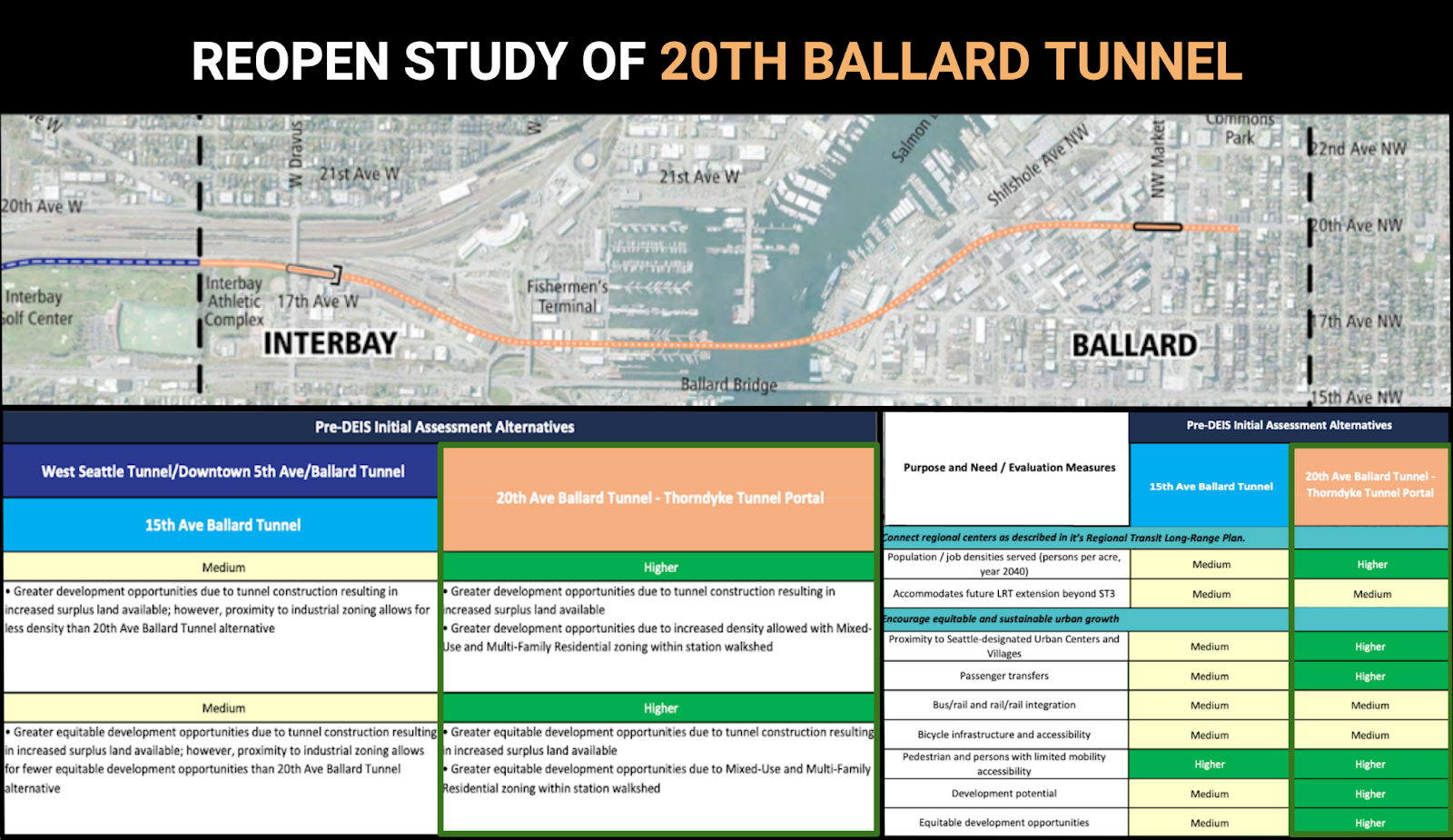
The good news is that Sound Transit studied the 20th tunnel option during Pre-DEIS work and discovered the obvious: A 20th Avenue station performed significantly better for riders than the other options presented. The bad news is the station was cut from consideration before the EIS process for cost reasons. But an interesting thing has happened since then: the EIS analysis brought cost parity between elevated and tunnel options in Ballard. An elevated 15th station with a drawbridge now costs the same as a 14th tunnel now. Would that cost parity extend to a 20th station? It might. We need Sound Transit to go back to the drawing board and find out, because the difference for thousands of daily riders is significant.
For anyone considering whether a station at 14th and Market is a good idea, we encourage you to take a walk from this proposed station location to Ballard Avenue or 24th Avenue. Anyone who has tried to take the D line via 15th Ave to visit Old Ballard knows something close to that experience. Is it impossible? No. But it’s far from a great ridership experience, especially for people with mobility challenges. It also involves walking across a dangerous intersection at 15th, which is seven lanes wide at Market.
Our multi-billion dollar 100 year light rail investment must actually be good, not just “fine.” Getting station locations and rider experience right needs to be the first priority for Sound Transit. We need to site the Ballard station where it is convenient for the Ballard that already exists, not distract ourselves with TOD potential in neighboring industrial zones around 15th and 14th. Recent history can be our guide: the Burke Gilman Trail’s arduous history of the Missing Link is an example of how challenging (if not impossible) it is to convert industrial land to other uses. Even if an upzone is possible, a 14th and Market station will never serve Historic Ballard Avenue or the dense 24th corridor well.
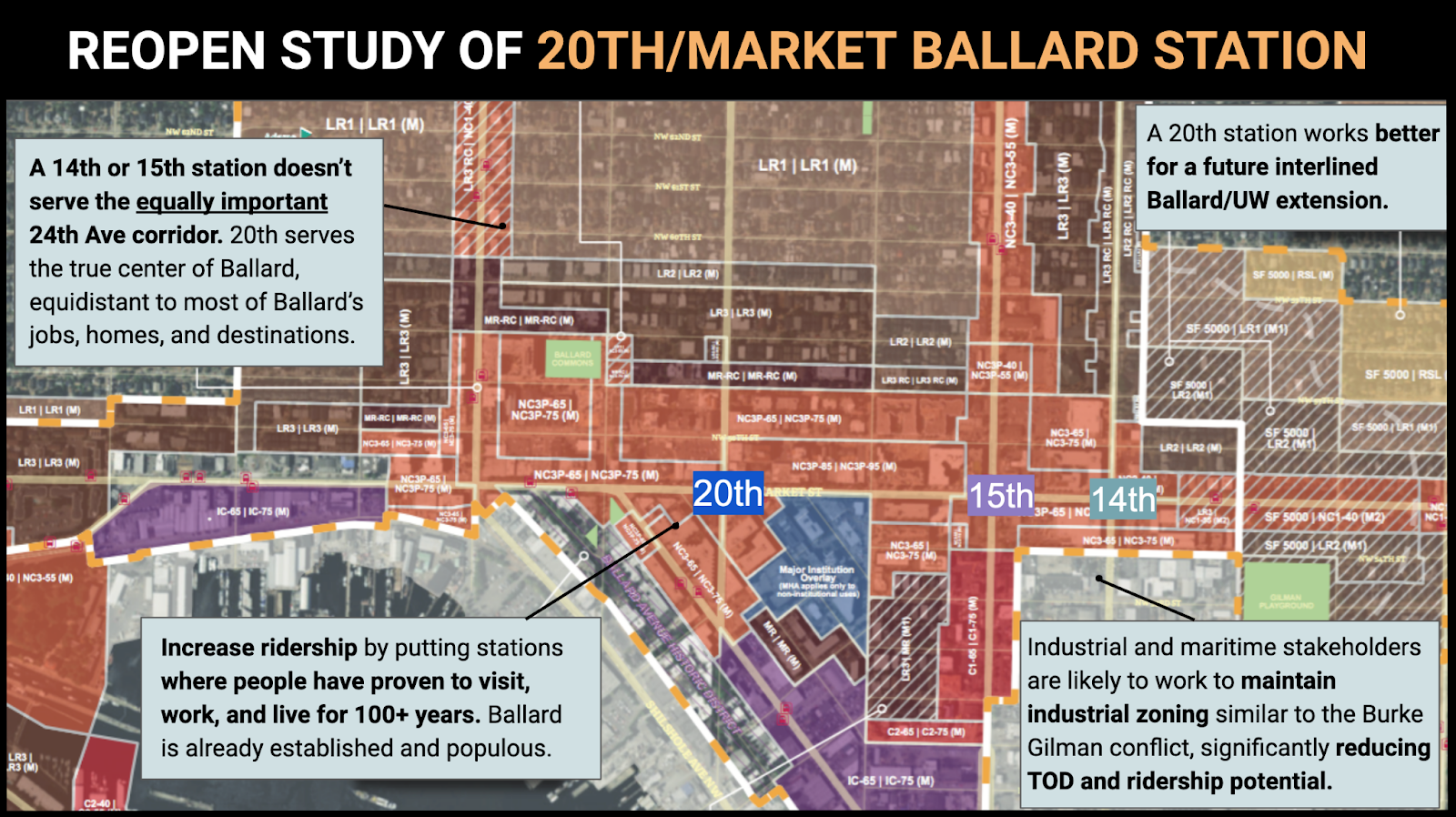
A 20th Avenue station is far better for future expansion too. Lines continuing to the north and east should connect into Ballard Station for one seat rides to downtown Seattle. An eastward extension could include an East Ballard station around 8th. Also, if we fail to build a station west of 15th, we’ll have to consider building one in the future, which would make the future Ballard/UW line far less desirable with forced transfers on both sides to access the rest of the system. It’s worth noting that a future Ballard to UW extension that isn’t interlined would involve another expensive tunnel transfer station at Ballard as well. Let’s just skip all that and do it right the first time.
That said, 20th isn’t the only station location option in central Ballard that could work. A station on 22nd could offset the continually rising land prices by using a significant amount of City of Seattle-owned land along 22nd Ave (including the Ballard Commons or Bergen Place) as potential locations for Sound Transit station entrances. There could be another central Ballard option that works better than 20th. The point is that Ballard station has to be in central Ballard and the options that made it through the EIS would require an additional future station to serve it properly.
There is still time to fix this: Submit a comment on the EIS and reach out to the Sound Transit Board to demand that a 20th avenue station in central Ballard is studied further.
Yes!!
The best option was the Thorndyke tunnel option, which was found to be relatively affordable!!
https://www.soundtransit.org/sites/default/files/documents/wsble-initial-assessment-alternatives-development-and-screening-202012.pdf
Yeah, it’s really too bad they didn’t include that in the EIS. How much money could excluding it have possibly saved?
Now they need to go back and find out.
Will not happen. Way too expensive to serve one small community
TIL: Ballard is a small community.
Ps: No one knows how much it will cost, that’s the point.
Ballard-Fremont is the fourth-largest urban village in Seattle. If that’s too small to matter, the whole region is screwed.
If you count the SLU/Downtown/First Hill as a single contiguous “Greater Downtown Urban Center,” Ballard is the 3rd largest housing growth center behind Greater Downtown and U-District, and Ballard is the largest housing growth center that’s not an “Urban Center”.
However, even the Urban Villages plan underestimated growth: we’re at year 7 of the 20-year plan and 69% of the planned housing has already been built; 79% of the expected new jobs have been filled.
West Seattle Junction (269 acres; 2015 housing: 4,430; jobs: 3,829), was planned to have 2,700 new residential units and 1,900 new jobs by 2035, and has also built or permitted two-thirds of that. 80% of the jobs have already been filled.
Ballard (495 acres; 2015 housing: 9,881; jobs: 8,381) is planned to have 4,000 new residential units (and 4,200 new jobs) in 2035, and has already built or permitted two-thirds of the housing. Jobs are lagging at only 14% fulfilled, and that reflects my observations of minimal new commercial construction.
What about our “friends” from the Port, who bigfooted their way into the process–IIRC, they are partially responsible for the potential 14th location because they opposed a bridge over 15th? Won’t they jump in again unless there is some serious turns?
Our understanding is that the port opposes the 15th elevated/drawbridge option which leaves a 14th tunnel as the odds-on favorite unless a better option is studied. As far as we know they don’t have an issue with the 20th/Thorndyke alignment.
There was no 14th alternative in the run-up to ST3 or in the ballot measure. The Port was Johnny-come-lately and opposed 15th after the fact. And since the Port is a large government entity and said the magic word “Jobs!”, ST deferred to it and changed the preferred alignment to 14th.
The extra engineering to extend the tracks several blocks from 14th and 53rd to 20th and 56th or Matket and move the station to be east-west feels like a “refinement” while rethinking the tunnel all the way under Salmon Bay (what Seattle Subway proposes here) seems like starting from scratch with a major new alternative to study.
I mention this as if a decision to not pursue a Salmon Bay tunnel is made, that advocates should not give up hope doing the former (14th Ave tunnel with tracks then turning west).
Wouldn’t it be nice to hit Safeway or Ballard Market on the way home though? Just sayin’.
Yes. 20th has been discussed a lot on this blog, and I am on board. I’ve submitted comment, and emailed the sT board and the mayor – for whatever good that will do.
14th is not a disaster, nor is 15th, but both are not good.
20th (or somewhere else west of 15th) is so obviously where this station needs to be that it is ridiculous that it’s not even under official consideration now.
I implore Sound Transit to reconsider, reopen the study of 20th, and get this right!
Why aren’t we adding a N Line Sounder station in Ballard? Extend the KCM 44 or 29 for select trips, serve the station, give folks a ~15 min to downtown. Do the same for Belltown and Expedia Campus area. We already have the rails, just need the stations. Were this Europe, Sounder would have stations every 1-3 miles throughout Seattle and we wouldn’t be waiting until late 2030s for service.
Sound Transit studied this and decided that the potential Sounder station location (well west of central Ballard) is too difficult to access to make it worth the investment.
North Sounder only runs a couple of times a day, too – so it would only represent a slight upgrade to current for a small subset of commuters.
One reason for the lack of riders on North Sounder is that the Seattle stop is at King St, which is a mile past where most riders are going, requiring them to then backtrack on some other transit back north. Adding a station to North Sounder would eliminate this backtracking and make the line more attractive. That said, in my view, Interbay is a better location for the infill station than Ballard. The benefit of such a station would be for transfers more than anything else.
I always viewed Sounder North as an “early win” to provide rail to Snohomish as well as political equity to operate Sounder South. It’s cost effectiveness is already horrible and will get worse when Lynnwood Link opens and even worse when Everett Link opens!
I’m not sure but I think that extending Sounder South northward from King St would require a new and very expensive renegotiation of track rights. And like others have mentioned, Sounder North at eight single direction trains a day is a weak substitute for 100-120 trains a day that would depart from a Ballard Link Station.
All of Sounder was an early deliverable. It was built because it could be started up quickly and inexpensively because the tracks were already there: it was seen as too much of a low-hanging-fruit not to do. But that was twenty-five years ago. Now it makes sense to ask if it’s still worth continuing. Sounder South is. Sounder North, not really.
I can’t believe that King Street Station deters as many riders as the limited schedule and not serving Lynnwood.
North sounder is also paid for by the Snohomish county subarea, which only cares about downtown. For them, a stop in Ballard does nothing for them except lengthen their commute, even if it were well used.
Mike Orr has it. But the Snohomish County subarea folks should suggest it; the funds could be used on improved bus service today; the rolling stock could be added to South Sounder. The Snohomish County subarea has no interest in a Ballard station; the North King County subarea has much better projects on which to spend scarce funds. When it was found that BNSFRR would not sell more than four trips per peak and not allow two-way service, the ST Board should not have continued with North Sounder. But they did. Amtrak will still be there.
When my daughter lived in Edmonds, she preferred taking Sounder….
She worked in Belltown.
It would mean hoofing it to the various bus connections. Any ‘BST’ delays meant waiting for the evening Cascades if she missed the 5:30pm Sounder.
In the morning, she eventually decided that the ‘BST’ to Downtown (same elapsed time as backtracking from KSS) gave her time to sleep.
She was always talking up the train ride, but coworkers didn’t like backtracking to KSS.
I’ve had people ask me about commuting on Sounder, but balk at using it if they work anywhere that’s too far north. (roughly north of Westlake)
As even Brian Bundridge, former BNSF foamer extraordinaire, who had a more detailed understanding than most on this blog about things railroad related, said a Belltown station is workable.
It’s low hanging fruit, a temporary station, such as the original Tukwila station is cheap. What’s the cost for lumber to build a split level house nowadays?
A pedestrian overpass already exists.
Build that at least.
It’s bad enough that Edmonds and Mukilteo won’t “upzone” in the station areas, (height restrictions prevent the current residents from being offended by the ‘character of their neighborhood’ being altered), because it would destroy their privileged views.
Not building a Belltown station means that the political movers-and-shakers aren’t at all behind transit alternatives.
Hell, it’s becoming obvious that the WA State Legislature is car-centric.
Apparently having the Tacoma Narrows Bridge users actually pay for the thing is being discussed.
Did anyone see any passenger rail improvements in the transportation package? (save for the gadgetbhan style HSR study money)
That has the same problem as 14th but in the opposite direction. People have to go out-of-way to the middle of nowhere to get to the station. Downtown has Link and dozens of buses every couple minutes to get from the Sounder station to other parts. With Ballard you’d have to take an extended 44, walk (unlikely) or drive. And if you’re north of Market Street it would be a 2-seat bus ride with each segment less than a mile, so you’d be waiting longer than you’re riding. That’s not enough time to read or settle into the segment; you’re constantly getting up and going in and out.
or even put a station at smith cove or interbay if not Ballard.
Why not have the north sounder train stop at smith cove so people could transfer to link there to go to either ballard or south lake union?
The alternative is for people to waste time going all the way to King Street and then backtracking to the north.
Then again maybe the secret plan is to get rid of North Sounder once Link gets to Everett.
Do you seriously think it would be easier to get from Smith Cove to northern downtown than from King Street Station to northern downtown? This is the kind of thing that looks practical on a map but not in reality, and would probably attract hardly any riders.
“maybe the secret plan is to get rid of North Sounder once Link gets to Everett.”
ST could have done that any time in the past fifteen years as we’ve been urging it to. Sounder South works because it goes through the middle of the population concentration. In Shohomish County the population concentration is between 99 and I-5, but Sounder is on the far-off shoreline and down a steep hill. So cancel Sounder North and put the money into replacement bus service and accelerating Link construction.
But ST has consistently rejected that position. It says voters expect voter-approved services to continue. That position may change when Everett Link opens, but there has been no sign yet of the ST board being sympathetic to that position. However, it will be another generation making the decisions when Everett Link opens, and who knows who will be on the board then? Maybe Avgeek Joe and Sounder Bruce?
“Do you seriously think it would be easier to get from Smith Cove to northern downtown than from King Street Station to northern downtown?”
For the average commuter in a few years after Link is built, and who might consider North Sounder if they work north of King St – lets say between Smith Cove and Westlake – when they consider that they have to go PAST their destination it seems like an obvious waste of time.
Whether it truly takes more time or not you can do the research on Mike, but appearances matter.
This is off topic, but what the hell. A station at Belltown would be the best option for an addition. If that is problematic, then Smith Cove or Interbay (as suggested below). These could serve Sounder South, assuming Sounder North is eventually eliminated (for poor performance).
Sounder needs to be decommissioned. Thats way to far away from the proposed stations and businesses to begin with. Let alone the tens of millions for A station that won’t get any ridership and only runs 1 way each part of the day. The only reason the sounder exists was to garner support of the Everett coalition to sign on for ST in the first place.
Give the Ballard industrial customers their 14th Ave NW, then curve the line NW along the Shilshole Ave ROW, right to 20th Ave NW, or another N-S street. You can get to central Ballard without even needing ROW for track.
What are you saying here? What does “their 14th Ave NW” mean, a station? Do you have ANY idea how deep that would be right next to the Ship Canal? At least one hundred feet, and there’s almost no “there” there to provide passengers. North of Leary there is mixed use, but the waterfront is 100% industrial there. Very few people actually work there.
Or, alternatively, ask yourself, “How high would that station be with a fixed bridge?” Well, about that same 100 feet. And then you have a visual barrier across the south end of Ballard until the structure can descend to a reasonable height, or, as I assume you mean, grade.
This is entirely impractical. I’m sorry to be harsh, but it is.
I don’t understand why you think very few people work in the industrial areas of Ballard. These are actual jobs that support families instead of minimum wage barista jobs. Pacific fishermen, Kvichak, Ballard oil, Salmon Bay Sand and Gravel, etc etc etc.
@Julie,
Sure, there are a few hundred jobs, and most definitely pay well. But ask around your break area and see how many of your co-workers take transit. As a guess I’d say you’ll get less than 1%.
For sure “Pacific fishermen” are obviously not regular transit users because they’re out to sea for several weeks at a time. Plus, they’re on the “wrong side” of the Ship Canal and if they did use Link once it’s built would be walking from the Thorndyke/Dravus station.
All I said was that there’s no need for a station right next to the waterfront on the north side, because nobody would use it.
Tom, I think it’s somewhat fallacious to ask a community that’s underserved by transit how many people take transit.
I’d love to be able to easily take a bus to Fisherman’s Terminal, but the pedestrian environment from the Rapidride D stop in the freeway interchange that is the south end of Ballard Bridge is awful, and it’s a really rough half mile walk from 15th to the Terminal.
If anything, providing the merchant fleet of Fisherman’s Terminal and the other commerce of North Interbay with easy transit to downtown would help make transit ridership feasible, not just faster for those who already rely on it.
Nathan, you’re being way too optimistic. The fishing fleet is moored a few months of the year, and the rest of the time a few boats at a time are at the slips. Everyone else is hundreds of miles away at sea, visiting once every three weeks to a month.
And let’s get real. The people who work at the BNSF engine facility — the only significant employer in the area — are mechanics; they like internal combustion engines. That’s why they maintain locomotives; those are about the biggest internal combustion engines in the world. Fun! Challenging!
And they drive. The truth is that Julie’s scorned baristas are WAY more likely to take transit than the denizens in the industrial districts.
Just out of curiosity, why would you want to go Fishermen’s Terminal? There’s nothing to do there that you can’t do along the Ship Canal under a nice shady tree a few blocks to the east — with no noisy Ballard Bridge above you.
Do you have friends or relations who have a fishing boat?
I’m just saying that maybe folks interested in improving transit accessibility shouldn’t admonished for wanting transit in traditionally low-demand areas.
My S.O. and I go the Fisherman’s terminal every once in a while for Bay Cafe (which is a meh-to-good diner depending on your opinion of diners) and I like to peruse the little fish market there and pretend I’ll ever have any practical need to buy an entire frozen salmon. We also enjoy walking around the docks after a breakfast at the Cafe and looking at all the different boats.
Yeah, the fish market there is excellent. It is also a nice place to walk around. My wife and I used to love the Highliner, but they raised their prices (to be more like typical fish restaurants). It is still good, just not the great value it used to be.
Anyway, back to jobs. Industrial jobs tend to be more spread out than in years past. In contrast, office jobs and medical jobs are still concentrated. Retail isn’t concentrated necessarily, but buying a car just to commute is likely to be a much bigger burden on those workers (whereas someone who works a high paying job is likely to own a car). In any event, https://onthemap.ces.census.gov/ does not show a high concentration of employment in any of those industrial areas, which explains why Metro doesn’t run the buses up Commodore Way, for example. It does run the 40 through Leary, serving industrial employees, as well as plenty of others.
Fisherman’s Terminal does get coverage via the 31. I don’t have access to the numbers, but my guess is it isn’t very high. Personally, I would abandon Emerson and send both buses to Magnolia, splitting on the west side of Dravus Bridge. I would try and boost the 33 as well. That means that someone getting to Fisherman’s Terminal would have to walk a little farther (https://goo.gl/maps/EEJqAzvchCvsjnSf6) but still within reasonable walking distance (about six minutes). Frequency and connections would be more important.
Some have suggested a Ballard to Magnolia bus, which also sounds reasonable. No matter what, Magnolia is tricky. You can’t build a grid. A trunk and branch system sounds reasonable, but then the branches get really bad frequency, even if some of the areas (e. g. Gilman) shouldn’t. You are left with buses looping around, and even then, the solution isn’t simple. Just when I think I have something good figured out, I realize there is a big flaw.
Anyway, back to the original suggestion. The big drawback of a station anywhere alone Shilshole is that half your walkshed is taken up by the water. I also don’t think you could pull off a turn like that, let alone a station at 14th (as Tom mentioned). In contrast, a line on (or above) Leary, coming from Fremont would be reasonable, and it could have a stop at 14th and Leary, along with Market. But this train isn’t going through Fremont (it is hard enough to get it to go to Ballard).
+1!
I’ve taken the D to the Ballard Farmers’ Market, and when I think about a Link station or monorail station there or RapidRide-as-BRT, I imagine what an out-of-town visitor would say, or what I would say if I encountered it in another city. “This is not the best transit network because the station isn’t right at the pedestrian center.” It reminds me of how the DC Metro is a longer-than-necessary walk to GWU, U Street, and Georgetown. In contrast, Pentagon City station is right at a shopping mall and office building, Chicago’s Library station is right at the library, etc. Every hundred yards further from the center loses more riders.
Developers have shown no ability to create a new neighborhood as popular with pedestrians as pre-WWII neighborhoods like Ballard Ave, University Way, and Pike-Pine. Those areas have human-scaled, vertically-oriented buildings with narrow storefronts that have more choices per block, and a wider variety of destinations. Recent buildings have shallow wide storefronts, which chain stores love for visibility and reducing competition, but it reduces the choices within walking distance. Developers can make new buildings like old buildings, but they only do it when they’re restoring an old building or putting a larger building behind an old facade (Pike-Pine has a few of those). 14th and 15th don’t have old buildings to restore; the underdeveloped lots are all industrial or one-story car-oriented buildings.
Agreed, and great analogy. I’m sure that DC regrets not adding the station for Georgetown — we don’t want to make the same mistake. Like DC, it could be a very long time before the situation gets fixed (https://www.npr.org/local/305/2019/11/12/778473521/why-doesn-t-georgetown-have-a-metro-station-it-goes-beyond-n-i-m-b-yism).
20th Thorndyke tunnel is EXACTLY what Ballard needs. Way more TOD potential/ridership/destinations/small businesses/cultural attractions, etc. Who wants to walk 10+ minutes to barely reach Ballard Ave and 24th Ave? Not me.
Re: 14th Station, we can definitely build second station in West Woodland later on when Seattle eventually expands to the East in the future ST4 Ballard/U-District Line.
20th is great and TOD is great. There’s some TOD potential in any of these locations, but not tons of TOD potential because the whole area is pretty built up already. West Woodland is not some hypothetical future West Manhattan, it’s getting rebuilt now with some like medium mostly residential density and new townhomes off the arterial that will be still be there in 2050.
The place with the true TOD potential today that nobody seems to talk about is Northgate, where the current meager height limits are vestigial and counterproductive despite the fact that it’s 14 minutes from downtown and a tabula rasa with no views to block. I don’t know who’s on the other side of the issue. I posit that simply removing all height limits there would do more for TOD than anything we’d ever do in Ballard, or West Woodland.
Sadly, it’s owned by a company that seems to hate human beings, yet it’s in the “mall” business. Go figure.
I agree with this post, but I think it is very important that ST not limit themselves to the original proposal, or something similar. It is very likely that a tunnel to the east is cheaper. It is also quite likely that it is cheaper to orient the station east-west, or northwest-southeast (under a street like Tallman or Russell). This leads to several options, and they should be studied.
For example, this is a fairly detailed and plausible proposal by Nathan: https://goo.gl/maps/7gD73hPp6HqghJu87. It is quite possible this is the cheapest, most effective design for Ballard. It would put the station in an ideal location, while enabling a future line from Ballard to the UW. It would even allow for an extension north (the train could curve again) in the unlikely even we can afford that someday.
We should study these and other options, instead of limiting ourselves to a north-south station orientation or a crossing west of 15th.
“It is very likely that a tunnel to the east is cheaper.”
Right, it doesn’t matter where the track between stations is, just where the station entrances are.
I’ve been staying out of the alignment-suggestion comments because I find it futile until ST shows some willingness to consider them. If ST is someday willing to consider a track on 14th turning to a station on 20th, that would be an opportunity. I don’t necessarily see an intermediate station at 14th & 54th in that scenario. I think the proponents of the 14th alignment aren’t thinking a 14th station is necessary, they just want Link away from 15th. So they may be willing to let the station move to 20th as long as 15th is train-free.
I agree that it seems futile to add station alternatives at this point. However, by the time groundbreaking occurs, this DEIS may be so old that ST will have to update and revise it anyway.
[deleted]
it seems that the exclusive motivation for a station on 14th is affordability
Yes, and interestingly enough, that is the main reason that they first preferred 15th. Everyone knew that a station to the west would be better, but they figured elevated was considerably cheaper, and 15th wouldn’t be too bad. Now 14th is the economical option (since it is only three minutes from 14th to 15th). Next thing you know the station will be at 11th, then 9th …
The cost estimates for tunneling are now comparable to aerial. That was not the case when the alternatives were winnowed. Generally, I think the entire honing of alternatives needs to be revisited due to such wild changes in capital costs — not just this one. They were honed too early.
I remain very perplexed on how this is true. Rule of thumb is tunneling should be 1.5x the cost of aerial.
yeah, I think tunneling is still generally more expensive, though it’s surely context-specific. We’ve seen West Seattle above-ground cost estimates converge toward the earlier tunneling estimates. But we’ve also seen an explosion in the downtown tunnel cost estimates. Tunneling has a lot of above-ground impacts because it takes a massive property taking to build an underground station, so it’s not immune to the general malaise of more expensive property requirements.
[deleted]
In West Seattle it’s more about the alignment and station type/locations than it is elevated vs. tunnel. The 41st Ave SW location for the Junction station is mostly parking lots, but it’s expensive to get elevated track there because other midrise buildings are in the way.
Property costs are also spiraling out of control. The assumptions made in the 2021 realignment are already looking to be wildly optimistic. So the tunnels may end up being cheaper in the end, plus they are far more popular than either at-grade or elevated rail.
20th Ave. is also much closer to Swedish Hospital for those with mobility issues. Patients and staff wouldn’t even need to cross a major road if there were station entrances on both sides of Market St. The way we bend over backwards to accommodate “accessibility” when it comes to cars, this is the least we can do for the transit system!
I think we should be planning two stations in Ballard. We are planning three in West Seattle and two in Downtown Redmond. I like the idea discussed elsewhere of crossing near 14th and stopping in West Woodland and Ballard. The 13.1K forecasted boardings (26.2K riders) at 14th would be larger with two walksheds rather than one — probably about 7-9K at each station. Note that Alaska Junction has a projected 6.4K boardings and Avalon has only 1.2K boardings forecasted.
I realize that pointing tracks to end west rather than east goes agains the Seattle Subway vision map. However the map has other design problems because of vertical challenges (like branching at Aurora or just south of Midtown) from bored tunnel walls that can’t be conveniently opened. Finally, the need for a through routing from Interbay to UW will be a pretty small market so that building an eventual separate Ballard-UW line rather than an extension isn’t really a system degradation.
Three West Seattle and two Redmond stations were in the ballot measure. For Ballard we’d be adding a station when the core costs have risen and ST is having trouble affording even a basic Ballard line. Stations are among the most expensive parts of a line
Still, from a coverage standpoint, one station for industrial southern Ballard and one station for retail central Ballard would be ideal. People should be able to walk to Fred Meyer from the staition. On the other hand, Fred Meyer should also have apartments above it and in the parking lot.
And if Seattle grows up to Vancouver level station zoning, the Fred Meyer is a great place for a podium + towers. I hope for a future where ‘industrial ballard’ looks like the U District station with a cluster of towers, while “retail Ballard” looks like Cap Hill station area. Different kinds of density and different kinds of urban vibrancy, both of which have their role.
Attributing station specifics to the ballot measure is in my mind a huge structural logic problem. Large packages were assembled for ST3 without proper study and public input. Some kid from a flat Chicago (Kubly) led the backroom alternatives with lousy lowballed cost estimates, no adjustments based on ridership forecasts and backroom pressures from certain elected officials and rich stakeholders meeting privately. They were called “representative alignments” in the measure and those morphed into hard and fast locations after the measure vote occurred. Dare I mention that suggested 20th/ Market is further from the representative alignment than First Hill is from Midtown?
“Attributing station specifics to the ballot measure is in my mind a huge structural logic problem.”
The point is the number of stations: the budget was scaled for that number. Additional stations are a large cost, especially if they’re underground. The representative alignment already faces increasing costs and ST is struggling to afford them, so now you’re asking it to add a station that people didn’t vote for? It would be one thing if the line were under-budget, but it’s over-budget.
ST didn’t paint itself into a rigid corner like the monorail did, where the ballot measure specified exactly which streets it would run on and where the stations would be. That was widely seen as too rigid, especially since later engineering might show that route was infeasible or another option is more promising.
“Some kid from a flat Chicago (Kubly)”
Kubly was not in Sound Transit.
The 15th corridor and the station at 15th & Market go back to the 1990s when ST’s long-range plan was first drawn up. It was assumed it would be cheapest to build on a six-lane expressway because the land was already public and there would be room for trains in the middle. It’s the same reasoning that led to Northgate and 145th Stations at existing freeway entrances and P&Rs. And you can probably go back to Forward Thrust in the 60s: I don’t know whether it used 15th but it likely did. And further back to the building of the expressway. These are all long-term precedents, not something Kubly suddenly dreamed up and everyone fell in line.
“Dare I mention that suggested 20th/ Market is further from the representative alignment than First Hill is from Midtown?”
There’s some arbitrariness there. But ST is not saying 20th is out of scope for ST3; it’s just saying we don’t want to. There are people who think the current and future development on 15th and 14th justify the location there. Lynnwood Link considered alternatives as wide as Aurora, 15th Ave NE, and Lake City Way. The only requirements were it must serve the Northgate and Lynnwood urban centers.
First Hill is an oddity then. But there are two things about First Hill. One, there’s a steep hill from 5th to 8th, so it’s not as easy for people on 3rd or 5th to walk to it as it is for people to walk from 14th to 20nd in Ballard. Two, it’s part of the downtown urban center, so that’s different from having no station in Northgate or Lynnwood. Three, the center of the downtown urban center is around 3rd or 4th Avenue, not 8th. Four, there’s a psychological difference when a neighborhood is larger and more urban. Three blocks can seem “out of scope” in a dense area but “in scope” in an undense area. Four, ST’s attitude was inconsistent over time. First it said we could argue to move Midtown Station to 8th later in the EIS process. Then when that time came it said it was too late, and First Hill was out of scope of what voters approved. Again, this goes back to the psychological aspect: is First Hill part of downtown or not? Is three blocks too far in a dense area? Those are questions where there’s disagreement, and what matters is what the political leaders who have the power to choose the alignment believe.
IIRC, Kubly laid out the SLU/ Ballard corridor and he and Murray put it into the ST3 package. That specific alignment was not studied in the prior Ballard to Downtown corridor study. In fact, because it wasn’t in that study, there were not even cost or ridership estimates available before it was added in.
It was done somewhat on a whim. Bring steadfast about it is fundamentally not rational.
“Kubly laid out the SLU/ Ballard corridor and he and Murray put it into the ST3 package.”
Those are different things. The 15th alignment and 15th/Market station go back to the 1990s as I said. A study for Ballard-downtown was included in ST2, and McGinn gave ST money to accelerate the study. That didn’t change the alignment or station; 15th and 15th/Market were still the frontrunners. Then in early 2016, Kubly and Murray suddenly introduced the idea of an SLU detour. That still didn’t change the Ballard alignment; it only changed Westlake to Smith Cove. And everyone realized they’d missed SLU — both the city and the county and Sound Transit and we transit fans dropped the ball — because if you build highrises they need high-capacity transit. So SLU was really an oversight that should have been considered much earlier. Anyway, the SLU detour was approved, and ST3 went to ballot with SLU and a 15th alignment and a 15th/Market station.
Then during the Alternatives Analysis, suddenly the 14th alternative that had never been suggested before appeared and became the frontrunner.
I have been sending Ballard Link people my stating the obvious need for an uninterrupted tunnel the bridge over top is obscene and a draw bridge would congest the created unreliable system. Imagine the system strangled each time the system had to stop the trains for sake of a boat! as in getting to the airport.
This penny wise, pound foolish argument seems to prevail at ST. I’ve asked them for a proposed map of the entire system such as 2075 and they can’t provide publicly the dream system. Personally, I see the Ballard line extended to Kenmore neighborhood then splits towards Monroe and Lake Stevens. UW already has one line. A cross track to Medina would/should be critical. I remember in DC when the Air Florida plane came down about 30 minutes later there was a crash on the only metro track crossing the Potomac at that time–the L’Faunt Plaza-Pentagon track wasn’t built yet.
The bridge is 70′, which is twice as high as the Fremont Bridge. Only a few tallest sailboats wouldn’t be able to go under it. The Fremont Bridge opens a few times a week, while ST says the Link bridge would open only a couple times a year. Even if that’s an underestimate, it would open much less frequently than the other bridges. You can’t just take your experience of getting stuck at the Fremont Bridge once a week and assume a higher bridge would be just as bad. It’s not, and maybe it’s an acceptable compromise to avoid the cost of a tunnel.
IBB-3 (moveable bridge to 15th) is estimated to be similarly priced to the 14th Ave tunnel options, and “only” ~6-12% cheaper than elevated to 14th or tunneling to 15th. Maybe that number could be bumped up if they studied connecting SIB-1 or SIB-3 to IBB-3, but based on the current numbers, it wouldn’t save very much. Besides, land acquisition costs are only going to continue exploding, so it’s likely the Tunnel option to Ballard is only going to become more and more (relatively) affordable.
After deep-diving the Triunity cost estimating reports, I think we’re going to see more shifts in the cost estimates come out for WSBLE and my guess right now is that a year from now, we’re going to see the Board decide the following:
1) Baseline and 2032-2035 timeline for a short tunnel to Alaska Junction from an elevated Delridge alignment, heading to a stacked SODO station.
2) Baseline and 2037-2040 timeline for a stupidly deep DSTT2 & Ballard Link MOS that ends at Smith Cove.
3) Cost estimate update and RFPs for ESZs to bring each of the projects with affordability gaps (Smith Cove to Ballard; S Kirkland/Issaquah Link; SW Everett to Everett Link; Tacoma CC Extension) to the current Target Schedules.
There is seasonal variation in drawbridge openings related to sailboat traffic. For Fremont, only 30 feet above the canal, in the early 80s, it opened up to 70 times per day. The drawbridges have closed periods in the two peaks.
If you’re looking for ST’s Long Range Plan on a map, see page 12 of the 2014 LRP Update: https://www.soundtransit.org/sites/default/files/documents/2015123_lrpupdate.pdf
If you’re looking for some sort of “vision” map that goes beyond the Long Range Plan, then you’ll be disappointed. They barely got ST3 to fulfill most of the additions to the LRP, but critical connections like Ballard-UW are still in need of initiative. Asking ST (or any organization) to think 50-60 years ahead is not useful or reasonable (just ask the Post Office and their recently-repealed requirement to pre-fund 75 years of benefits).
The industrial businesses in Ballard want the bridge at 14th, not a station
OK, thanks. But it’s still impractical. The bridge at 14th is supposed to be a fixed one; it’s usually pictured as a cable-stayed one with long approaches on both sides. I really don’t think you want an abrupt curve at the north end turning west, even if it’s practical from an engineering standpoint. There would be a 100 foot high barrier across South Ballard at least past 15th. That would be quite the visual intrusion.
Without a station it would work fine with a tunnel, unless the sewers in the neighborhood cross the path.
I think a Tallman or Russell approach with the actual station lying under 20th just north of Market is the best alignment, because it makes going on north a lot easier and straightforward. Since Market would have to be crossed with cut-and-cover in order to have a fairly shallow station, when the cut is covered it could include horizontal pathways above the track box leading to Swedish and Seattle’s “SoMa”.
The Thorndyke Portal/20th Avenue Station solution is limited because it doesn’t serve West Woodland. At least, not the part of West Woodland that its practical to redevelop.
Assuming that Subway’s dream of a split north of the station comes about, the earliest practical north-south street under which the Purple Line to UW and Kirkland would lie is 59th NW. That’s deep into the SFH part of West Woodland that Ross rightly scorns as a poor site for a station. A station at Eighth and 59th would be blocks from any building taller than two stories.
Of course, if the TBM’s go deep they can go any direction without disturbing the peace above them. But then you end up with deep-deep-deep stations all over the place and oddball orientations to the street grid for station entrances.
Nathan’s idea would have been the best solution if it had been built five years ago, before the impressive rows of large apartments lining 56th were built. However, they have been built which means that you can’t use TBM’s at any shallower depth than sixty to seventy feet below grade. That makes the platforms just west of 20th also sixty to seventy feet below grade.
I expect that the Thorndyke tunnel portal alignment assumes roughly the same depth for its station too.
I know that cut-and-cover is unpopular with people, because it means that roads are intermittently closed for decking and removal, and there’s the noise of all that excavation. But it means that stations can be considerably shallower, improving the rider experience permanently.
So I’d belly the bored tunnels out farther to the east, perhaps as far as Eleventh, and then swing back westbound either under 50th or 52nd, depending which diagonal street is to be used to get to 20th. As soon as the east-west heading is reached, the transition from TBM to cut-and-cover would be made and the profile would continue rising to 14th where a station would be placed between 14th and 15th, with an entrance on the both sides of each of those streets. A double track railway can easily fit between the curbs of either 50th or 52nd because it’s only about twenty-two feet wide.
The trackway would continue west, resuming its rise west of the West Woodland station and then at 17th curve into Russell from 50th or Tallman from 52nd. The trench would continue on Tallman all the way to Market, and under Russell to 20th where it would turn north. The Tallman trench would require taking the brewery and possibly the building next to it at 20th and Market.
Either alignment would place the station under 20th just north of Market with a walkway over the tracks between the Mezzanine and south of Market street.
To enable a Ballard-UW connection the portion of the tunnel east of 14th would probably have a level-crossing to a stub headed on eastward. Or for more money and distruption it could provide from a flying junction, but that would require taking some houses above it.
Of course they could be replaced by apartment buildings when the project was finished.
“earliest practical east-west street under which the Purple Line could lie”. Oy-vey!
Also “it’s” instead of “its practical to develop”.
Flip the Ballard-Downtown line and the eastward extension, making the latter the main-line and the former a later extension. Because it would not require the building of a second Downtown tunnel, in that riders could avail themselves of excess capacity on the Northgate-Northgate line, the timeline could be accelerated to 2036 (the original promised completion date!). A surface station and line to 8th (with tunneling beginning east of there) would cost considerably less than a north-south underground station and line.
That’s certainly true, but people have been pretty vociferous in opposition to putting dedicated lanes on Market Street.
I think the bill that gives Seattle the right to use the authority to build its own rail (that Seattle Subway pimped hard for) is the trojan horse way to get Ballard to UW built first. Unfortuately, Big Tech (and their SLU stop) will stop that from happening.
FYI, one more obstacle to Ballard to downtown…..
That could be avoided by building along Mercer St.
The project could also be accelerated if the Uptown portion would be elevated, may be even as nice as Montreal is considering: https://twitter.com/CDPQInfra/status/1501673770217525252/photo/1
That would avoid delays getting to the platform after a major event.
This makes much sense. Desperate for east west and with connections could still be fairly quick to downtown . Problem is it still ignores Interbay, Queen Anne and Magnolia. We are always last here in north interbay for any decent transit.
Also, Bardamu, U-District station was built without provision of a demising wall through which to construct an underground passage to a new line. In ST’s defense, nobody knows if that line would be under 45th, 43rd or connects at UW Station.
Since the U-District has a center platform, it has no ability to be connected itself, so some provision would need to be made at the Mezzanine or at some level between them. Given the great depth and weight of the station, it’s a good bet that ST is not going to want to pierce the walls, So and transfer is likely to require a trip to the surface and back down to the second leg of the journey.
Obviously, that won’t be at the same eighty-five foot depth, because the line has to cross above or (Dios forbid, below) the existing tubes. Assuming the best case of tubes above the current ones with a ten foot clearance, the new platforms would be about fifty-five feet below grade. That would mean a vertical displacement of nearly one-hundred and fifty feet each transfer.
As daunting as the proposed transfer between DSTT2 and DSTT at Westlake would be, at least a passenger wouldn’t have to pass the level of his or her destination on the way to surface and then head back down.
So don’t be thinking that “Ballard-UW” is going to be a popular replacement for Ballard-SLU-Downtown. Ross, Mike and d.p. all think / thought they were interchangeable, but they really aren’t.
14th or 15th is equally as good as 20th. You can’t walk a few blocks ? Don’t be ridiculous
“1/2 walksheds are wrong! If you won’t walk 20 minutes to your train station every day, you don’t deserve a train!”
*1/2-mile
Or course you can. But, it’s still an extra 10 door to door minutes for every trip, both directions, which adds up.
Plus, lots of people are lazy and won’t do it even if they are perfectly capable of it.
This is not like detouring a bus, where people going to one destination save some walking, at the expense of longer travel times for everyone else. This is about siting the station. Wherever the station is, the train will get there fast, so you want it where it can get the most riders, including lazy riders.
20th is much better than 14th/15th. Don’t be ridiculous.
The students to
Ballard high for one would use 15th more. They use metro and can transfer.
Looking to the past, 20th beats 15th. Looking at today, 20th and 15th are tied, with 20th having a slight advantage. Looking at the future, 15th is the clear winner. It’s where most of the growth between the two areas will occur. The comment section knows a few things about transit, but visionaries they are not.
Just like there is growth opportunity east of 15th, there is opportunity west of 24th which is still accessible from 20th, but not from 15th. If you build two stations, you could capture both opportunities. You might even consider a station on 22nd instead of 20th in such case.
Looking to the past, 20th beats 15th. Looking at today, 20th and 15th are tied, with 20th having a slight advantage. Looking at the future, 15th is the clear winner. It’s where most of the growth between the two areas will occur.
Wrong on several counts. First, 20th has significantly more residents and visitors than 15th today. Second, 20th will continue to have the advantage into the future. They are building six story buildings to the west (even west of 24th*) and building town houses to the east. Neither will be replaced in the next 50 years. 20th is better now and into the future.
* These three (large) buildings are to the west of 24th:
https://www.seattleinprogress.com/project/3028825/page/1
https://www.seattleinprogress.com/project/3030168/page/1
https://www.seattleinprogress.com/project/3037590/page/1
That last building will be on 25th, about a 12 minute walk to 15th. If you walk 12 minutes east from 15th you get to 6th Avenue. If they ever build buildings like that around 6th, then a station at 8th or 9th (as part of a Ballard to UW line) would be a fine way to serve it. Either way, 20th is clearly the center of the area now and likely forever.
The students to Ballard high for one would use 15th more. They use metro and can transfer.
A bus along 15th would serve the station, no matter where they put it. If the station was at 14th or 20th, the bus would turn on Market, delaying riders a couple minutes at most. I doubt you lose any riders from Ballard High as a result.
While *those* riders would benefit from a station at 15th, other riders would be worse off. Riders on the 40 would see their bus make a slower trip to Fremont and South Lake Union. Riders closer to Leary would have to walk a considerably longer distance to the bus stop. Overall, from a transit network standpoint, 20th is the best option. Whether we can afford it or not is a different issue. But we won’t know unless we study it.
On what metric does it perform significantly better?
It’s more costly (maybe another $750 million!) because it’s so disruptive, and makes no difference to ridership. 20th has an advantage for riders from urban Ballard, but is inferior for bus transfers, yielding no more riders on net than the cheaper alternatives.
I understand why it’s unintuitive that a Ballard station isn’t in the place many entertainment district visitors think of as Ballard. But you need to engage with who is actually riding the system. A lot of riders are coming from somewhere other than the neighborhood of 20th.
But most of the riders will be coming from around 20th because that’s where they live, work, or their destinations are. I don’t see many bus transfers at this station. ST may say ridership equals out but that’s questionable, and the transit network would be less effective and wouldn’t serve the village as well. So either there will be fewer riders, or there will be a long-term feeling that the line isn’t as useful as it could have been. It also limits the number of people who can live within walking distance of the station. That’s a precious rare resource that we must maximize.
On what metric does it perform significantly better?
It’s more costly (maybe another $750 million!) because it’s so disruptive, and makes no difference to ridership
Really Dan? I expect better from you. I realize you are busy, and can’t read everything, but as a frequent (and excellent) contributor to this blog, I expect you to keep up. The reasons it performs better were explained quite well in this article: https://seattletransitblog.wpcomstaging.com/2019/03/21/a-better-ballard-option/. A few quotes:
“This location is closest to all of the current density, and closest to potential future development … Land uses other than housing also favor 20th … Sound Transit found (p. 29) that a station on 17th generally had a couple thousand more daily riders than one on 15th. Given the demographics and land use patterns I’ve described, this seems like an understatement. Furthermore, a station on 20th should amplify the trend.”
The author has facts to back all of these points. Simply put, more people visit, work and live close to 20th than the alternatives. That would lead to higher ridership.
As for the costs, we have no idea! That’s the point. Everyone (including me) assumed that the cheapest option was above ground, by a big margin. That is why they came up with what was obviously a compromise (a station at 15th). Everyone knew it was less than ideal (too far to the east) but we assumed it was much cheaper than underground, and wouldn’t have the issues that an above ground line to 20th would have.
Except now the difference between above and under ground is minimal, as this comment clearly explains: https://seattletransitblog.wpcomstaging.com/2022/02/17/wsble-deep-dive-interbay-and-ballard/#comment-889984. If a station under 14th is as cheap as a bridge, then it is quite possible this is true for a station under 20th as well (especially if it is oriented east-west or northwest-southeast).
It is quite possible that a station at 20th is no more expensive than the alternatives, and yet would would clearly give you the highest ridership. Thus it would give you the best performance by every metric imaginable: Ridership per dollar spent. Rider time saved per dollar spent. Increase in transit modal share per dollar spent. You name it.
Given all that, doesn’t it make sense to at least study this option?
20th has an advantage for riders from urban Ballard, but is inferior for bus transfers
Not necessarily. It is quite likely that there will be just as many people coming from 24th as 15th. The 17 would surely go by the station (and will eventually return to all-day), but it isn’t clear that the 28 will. They might decide to keep it as is, since it provides a fast one-seat ride to downtown, along with coverage (on 8th and 39th) that would be missing if the bus turned on Market. Riders from Fremont could backtrack on the 40, but why would they, since it would be faster to just ride the bus the other direction to the main destinations (SLU and downtown). In terms of which would be better for riders that want to transfer, it seems like 20th and 15th are a wash, while 14th is worse.
To actually calculate the number of riders who would come out ahead or behind for each station would would require a level of sophistication from Sound Transit that would be unprecedented. Holy Cow, they never wanted a station at 130th! To suggest that they have this all figured out, and know exactly which way the buses will run, and which route would be the best for riders wanting to transfer is ridiculous.
A lot of riders are coming from somewhere other than the neighborhood of 20th.
Yes, and a lot of those riders will never transfer to Link. You need to look at the bigger picture, and how this would effect the overall transit network. You mention disruption, while ignoring the fact that a station at 14th or 15th is a lot more disruptive to the bus network! The 40 would be pushed away from it’s current route, which is both a fast connection between Ballard and Fremont and one that provides necessary coverage along Leary. You will create a service hole, while also pushing the bus into traffic.
We don’t know which station location is better for riders who transfer. What we do know is that a station at 20th is better for the overall transit network, and that it will get more walk-up riders. It is clearly better.
A lot of people have hand-waving explanations for why one station might be better than the other. They might even be right. But the Sound Transit analysis did not show 20th was better than 14th or 15th. It showed they would have the same number of riders, though a somewhat different set of people. That’s why I included the link.
Think about this another way – there is precisely one station in the NW quadrant of Seattle north of the canal. If you can’t raise your sights higher than the walk circle around that station, why are we spending so many billions on it? We’re building a regional system with vast stop spacing, not an urban rail system, and wide sectors of the city will be connected to rail only via buses. You’d better believe the bus network is going to channel people to this station or the station falls flat wherever they put it.
RossB’s point about the 40 on Leary is a good one, and an example of a larger principle. A well-sited rail station (like 20th) means the buses can support transfers at the station, as well as direct service to the highest concentration of destinations, by going to one place. That makes for efficient routing. It also makes for efficient trip-chaining. Arrive via one mode, do your errand, then leave on the other mode.
U District Station was well sited on Brooklyn Ave. Putting the Ballard Station on 14th would be like siting U District station on 4th Ave. NE in Wallingford. Hey, college kids are fit, they can walk a few blocks, right?
U-District Station was sited well, but designed poorly. Having to exit on the west side of the station, when the vast majority of the ridership comes from the east, was a major design fail that now cannot be fixed. It was by sheer accident that there was a way to retcon stairs into the station.
If Real Ballard wants a station, they better be prepared to (1) lose some historic mid-rise buildings that happen to be sitting on the station construction box; (2) suffer traffic disruption related to construction for a few years; and (3) not let nostalgia for some favored pieces of architecture turn the station from one that has the best pathways in all directions to one where the limited entrances are hidden on the far side of the building.
Poor entrance design could even turn a 15th Ave NW Station into feeling like a 14th Ave NW Station.
All that said, the two things going for a 15th/Market Station are that there is a lot more land there that could be turned into mid- and high-rises and all the bus routes could easily intercept there, including one that could head up 8th Ave NW but also loop around on Ballard Ave before its layover.
I understand some don’t want a few years of disruption on 15th Ave NW. But the same disruption problem would apply to the 20th/Market Station, just a different set of disrupteds.
A lot of people have hand-waving explanations for why one station might be better than the other.
It isn’t hand waving Dan! Holy cow man, do I have to cite the entire article. Here is just an excerpt:
Census tract 47 extends from 8th Avenue to 24th Avenue, and from 60th Street to the Ship Canal. In 2018, the area of the tract west of 15th had 2 ½ times more population than east of 15th. And it has been pulling away. In percentage terms, it grew 4 times as much from 2010-2018 (86.6% vs. 21.8%), and 3¾ as much in the prior decade.
A 5 minute walkshed for 20th captures most of the taller buildings in the area, while 15th reaches a small fraction, and 14th reaches only a handful of buildings. A 10 minute walkshed for 20th gets to all except far-flung buildings at or beyond the corners of the urban village. The 10 minute walkshed for 15th barely gets to 60%. 14th doesn’t even get to 20%.
Those are facts, and the article is filled with those. There are numerous sources supporting this idea, including new developments (https://www.seattleinprogress.com/) which clearly shows that high density buildings to the east are limited to major arterials, while high density buildings to the west are on every street.
It is proponents of a station to the east who are doing the hand waving. They are imagining that high end townhouses and industrial land will be replaced by 8 story apartments matching those to the west that are largely there, yet still are going up at a higher rate. They imagine that this intersection (https://goo.gl/maps/TUWDsFeoDx6QCptx8) will go from being hostile to pedestrians, to the next Broadway and John. They imagine that people as far away as Phinney Ridge will flock to a station at 14th, just because.
Anyone with any experience looking at these things would conclude that of course 20th is the better station, just as they would have guessed that Capitol Hill Station would get a lot of riders when it opened. And guess what? They were right!
That’s why I included the link.
Yes, and your link had little to say about ridership. Here is the link (from the article you didn’t bother to read, obviously) that shows more detail: https://www.soundtransit.org/sites/default/files/west-seattle-ballard-stakeholder-advisory-group-meeting-8-presentation-20180905.pdf#page=29. The first you will notice is that 17th has the highest ridership, while 14th is the lowest. But the big news is that 20th wasn’t even studied! Your claim that ST concluded that the ridership would be the same is simply false. The point all of us are making is that once folks actually study 20th they will find that ridership is significantly higher, while costs are similar (i. e. ridership per dollar spent will be better than all of the alternatives).
Dismissing the overwhelming amount of evidence while making assumptions about what ST has already studied (and concluded) is simply a very bad idea. We can do better. We should study what all evidence suggests is the best alternative.
Think about this another way – there is precisely one station in the NW quadrant of Seattle north of the canal. If you can’t raise your sights higher than the walk circle around that station, why are we spending so many billions on it?
Seriously Dan? Do you really think that I completely ignored the role that buses play in ridership for Link? Me? Holy shit, man, I don’t think there is anyone on this blog, or in this city that has talked more about the importance of bus and rail integration. I wrote this article, based largely on that concept: https://seattletransitblog.wpcomstaging.com/2014/06/30/ballard-uw-should-be-the-next-light-rail-line-in-seattle/. Notice the section titled “Complements the Bus Network” and a term I coined: “bus catchment”. Meanwhile, I have been a huge proponent of a station at 130th since I first started getting involved with transit issues. As I’ve explained many times, the *only* reason a station at 130th makes sense is bus-to-rail integration. Do you really think I, of all people, completely ignored the bus network in all of this?
Get real man. If I thought that 14th or 15th was considerably better from a bus network standpoint, than I would be OK with either option. But it is the opposite. For reasons I explained, 20th is best from that standpoint, just as it is best for walk-up ridership.
You’d better believe the bus network is going to channel people to this station
Of course it will channel people to it. No one is arguing otherwise. But it won’t channel everyone. Is that what you are arguing? That this will be like 130th, where walk-up ridership simply won’t matter?
Dude, that’s crazy. The transfer penalty is real. Everyone knows that. Even proponents of systems based on transfers (https://humantransit.org/2009/04/why-transferring-is-good-for-you-and-good-for-your-city.html) knows that the data is very clear on this. There is a penalty — measured in ridership — for each transfer. (Walker is simply arguing that it is less than the other penalties, like that of low frequency.)
You are going to get *some* of the people from the 40 to transfer, but not all of them. A lot of the riders headed downtown or to South Lake Union will simply stay on the bus. You are going to get plenty of people from 15th, assuming the bus will be truncated. You will get people from 32nd (i. e. the 17) for the same reason. You may even get people from the 28, if they decide to modify it and send it west (personally I think that is unlikely, but possible). But that’s about it. The 5 won’t turn and go to Ballard — that would be crazy. Nor will riders from the 5 transfer to the 44 and then transfer to Link. The same is true for the E, or course. The 40 or D could be sent on 85th (e. g. https://seattletransitblog.wpcomstaging.com/2022/02/15/improving-metro-40-and-d/) and a few riders on 85th could head west to pick up Link, but most will head east (it is faster to downtown, and the UW is a much bigger destination than anything served only by Ballard Link).
In short, at best the bus catchment area of this is roughly everything west of 8th NW, and many of those riders will just keep riding their bus (since Link won’t offer anything different for a lot of the destinations). This is *not* Ballard to UW (which would connect just about everyone west of I-5 and north of the ship canal to the UW or Ballard via a fast two-seat ride). This is *not* the 130th station, where walk-up ridership is just a bonus. Walk-up ridership is hugely important for this station. It makes sense to maximize it, if doing so is relatively cheap.
Oh, and no one really knows what the bus network will look like after Ballard Link. I’ve made the argument (as others have) that the D, along with the 15 and 17 are truncated in Ballard somewhere. But what if they’re not? What if Metro decides to keep the one-seat ride to downtown, just via a different route. For example, what if they did this: https://www.google.com/maps/d/edit?mid=1-b58bY30_Vnnrwt3_SQvPhW9Qek1vuqN&usp=sharing
This solves some (but not all) of the issues that have been discussed. All of the buses in the area connect to the Link station. The 40 has been modified, but is still reasonably fast, as it doesn’t take a lot of turns. It also backfills coverage along 8th (taking over for the 8). The D backfills for the 40, serving all of its current stops north of the ship canal, as well as the increasingly dense Leary corridor area. It even backfills 39th. You still have a new service hole (on Leary in Old Ballard) but it has been minimized. Meanwhile, riders of the D still have a fast one-seat ride to downtown. They lose their one-seat ride to Queen Anne, but pick up a one-seat ride to South Lake Union, along with Fremont (although it will require a bit more walking). It isn’t as efficient as truncating the buses in Ballard, but I could easily see Metro (and riders) being quite pleased with this setup. You’ve maximized the number of connections to Link, while providing plenty of coverage and great connections. It is quite likely you’ve maximized transit ridership.
And yet you haven’t maximized Link ridership. That’s because given the choice, people often prefer taking the bus (instead of transferring to the train). When Link got to the UW, ridership on the 70 and 49 *increased*. People preferred taking the one-seat ride to downtown or Capitol Hill. With a network like this, there will be plenty of riders who transfer there. But the vast majority won’t have to. Ridership will be almost completely dependent on how many riders walk to the station, as it is with most stations around the world and most of the stations on this line.
Of course bus-to-rail integration matters, but if that is your only goal, you would have a completely different network (starting with Ballard to UW).
U-District Station was sited well, but designed poorly. Having to exit on the west side of the station, when the vast majority of the ridership comes from the east, was a major design fail that now cannot be fixed.
Yeah, but it is a pretty minor flaw. Either way you have a short walk to the Ave that doesn’t involve crossing the street. Ideally we would have an entrance on the other side of 45th, but we are really splitting hairs here. Entrances matter; of course they do. But using Jonathan Dubman’s great analogy, a station at 4th in Wallingford — no matter how great the entrances — wouldn’t make up for the fact that it was in 4th in Wallingford, instead of the U-District. It is very common to have inconvenient entrances to Subway stations. Often you have to cross a very big, busy street if you are headed one direction or the other (uptown or downtown).
If Real Ballard wants a station, they better be prepared to (1) lose some historic mid-rise buildings that happen to be sitting on the station construction box; (2) suffer traffic disruption related to construction for a few years …
Nonsense. The ideas that have been looked at the most don’t involve that at all. Tom wants the line to go on one of the angular streets (https://seattletransitblog.wpcomstaging.com/2022/03/10/st3s-ballard-station-has-to-serve-ballard/#comment-890980). Nathan has an in depth proposal for a station a block north of Market (https://goo.gl/maps/7gD73hPp6HqghJu87). Dale proposes running the train north-south over 20th, with the ending just north of Market (https://seattletransitblog.wpcomstaging.com/2019/03/21/a-better-ballard-option/). In none of these cases do you destroy old buildings. There are big empty parking lots that can be used for the work. From a traffic standpoint, this is likely less disruptive than most of the plans, and no worse than anything else. 20th is a minor street. 56th is even less important.
This is a terrible idea. It’s a recipe for making the project cost more and take longer to deliver, not to mention under serving future residents living east of 15th. .
Take a look at a map. 14th/15th is the geographic center of the travel shed for this station. It’s 18 blocks west to 32nd, and 17 blocks east to Phinney. The exact midpoint. Now look at a city zoning map. Lots more dense infill coming to the areas east and south of the station location.
Now, add a giant, Netherlands-level bike facility to the station and convert Market St. into a bike/ped-friendly complete street, and you’ve got synergy on a 24/7 east-west axis anchored by the station in the middle.
Stop fixating on planning such a long term investment based on what’s here today. Focus instead on what will be there in 2036. That’s a much more favorable scenario for a larger number of future riders.
It’s like hockey: skate to where the puck is gonna be, not where it is.
We can plan for the density that could be allowed in the future, or we can plan for the density that’s being permitted and built. For every apartment being proposed east of 14th, there are two being built west of 24th. Old Ballard is the heart of Ballard, and folks commuting by bus or bike from the north or east can easily handle the extra 10 seconds to a 20th Ave station. Folks living in apartments east of 24th aren’t going to be motivated to walk a full mile to the station, across multiple major intersections.
The neighborhood north of the 20th street station could grow upwards much more quickly than the area north and south of the 14th avenue station, and putting the Ballard station half a mile from 90% of the walkable businesses in Ballard is stupid if we don’t have to do it.
I agree that a tunnel west of the Ballard Bridge is not feasible, but crossing east of Ballard Bridge and turning west toward Ballard is feasible, and should be studied.
Does anyone think that zoning restrictions will change by the a Ballard station opens? SLU and the Soring District looks nothing like they did in 2000, and that’s about as far from opening day as this station would be.
Market forces and lobbying will change zoning and development in ways that we can only speculate. I particularly chuckle at the obsession of estimating affordable TOD potential down to the nearest 10 units when no projects can break ground until construction is almost finished. We may not have an affordable housing crisis in 2042. We are more likely to be making macro climate crisis choices and our buildings and cities will pivot off that more than it will pivot off of TOD opportunities in a single parcel.
Just because zoning changes doesn’t mean an area gets developed. Look at what is being built now in the area to the east of 15th. Other than the arterials, there are two basic things: Very nice townhouses and industrial development. Both are very valuable per acre, and thus unlikely to be converted to six story apartment buildings like those to the west. Oh, and a lot of the industry is old (and dirty), so digging up the land to build anything big is extremely costly.
It is easy to wave your hand and suggest that eventually every place gets developed to the same level, and ridership will be identical at every station. Except no city works like that! None. Cities are more organic. History matters. Capitol Hill Station is one of the highest performing stations, and will continue to outperform most stations 100 years from now. The same is true with Ballard. You simply can’t reproduce what exists in Ballard, and frankly, no one is trying. No one is trying to put in a hospital there and it is damn near impossible to reproduce the historic architecture that everyone finds attractive.
This whole idea that existing neighborhoods don’t matter is ridiculous. Using that logic, we would simply go off in random directions, figuring that eventually the area will build up. Pretty soon, Mount Baker and SoDo will have the same ridership as Capitol Hill, or what a First Hill station would have. Sorry, no. Station placement matters.
Density tapers down east of 14th. It will never be like west of 15th unless the city changes the zoning again. There’s no proposal to do that and no indication the city would consider it. A large dense neighborhood from 14th to Phinney is a fantasy at this point. We can’t made alignment decisions based on such long-shot what-if’s, because it’s 99% likely they won’t happen. I can just as easily wish that Roosevelt and Northgate have a cluster of highrise condos like eastern Vancouver and New Westminster, but there’s no indication that the powers that be will allow it.
“Does anyone think that zoning restrictions will change by the a Ballard station opens?”
They might, but we have know way of knowing what, how much, or when. So we have to assume the current semi-adversion to density will continue. The city and most nimbys have gotten over BANANA (“Build Absolutely Nothing Near Anybody Anywhere”) and accept urban villages as inevitable and unstoppable. But that doesn’t mean they’ll be willing to double the villages’ area or upzone the entire city in ten, twenty, or thirty years. They might, or they might not, so we have to assume they’ll continue doing what they’re doing.
Ideally we’d be like Chicago’s North Side, with a continuous urban village from Stone Way to 15th Ave NE and the Ship Canal to 65th, and a larger village for Ballard-Fremont. And fewer parking minimums and more transit-priority lanes. But the city and most residents are against that, and there’s no reason to believe they’ll change their mind soon. They could have changed their mind in the past twenty years but they didn’t, so why would they do so now?
Environmental factors may change the calculus, as the disadvantages of driving, low-density, and separation-of-uses become more apparent. But again we don’t know when/if it might raech a tipping point.
“SLU and the Soring District looks nothing like they did in 2000”
SLU’s upzoning had been intended since the 1950s. The city kept kicking the can down the road, but everybody knew it wouldn’t remain decaying 1940s industries forever. The city finally got around to upzing it and the highrises appeared in the 2000s. The Link alternative didn’t emerge until ten years after that.
Likewise, Spring District planning goes back to the 1960s and Forward Thrust. It was also a decaying industrial area, and it was planned to replace it with multistory offices and apartments. So when Link was proposed in 2008 in Bel-Red, it was following a long-established growth plan.
Ballard isn’t like that. The urban village is already established west of the station, and it grew in the 2000s. Southern Ballard will remain an industrial area as far as we know. Eastern Ballard (14th) is a shoulder area between the two, so it will have some multistory buildings but not as much as west of 15th. Seattle allowed SLU to be converted but it wants to keep most of its other industrial areas, for the diversity of jobs, commerce, and resources. So we can’t assume that just because SLU was upzoned to highrises in the 2000s and the Spring District to midrises, that the same will happen in eastern and southern Ballard.
Take a look at a map. 14th/15th is the geographic center of the travel shed for this station. It’s 18 blocks west to 32nd, and 17 blocks east to Phinney. The exact midpoint.
Do you really think people will routinely walk 17 blocks to the station? Seriously? What you are you, a realtor? (For Sale, nice house on Phinney Ridge close to future Ballard light rail station).
To someone who lives on Phinney Ridge, this station, no matter where it is, will be irrelevant. Maybe an urban hiker will venture out and use it for some grand loop, but for day-to-day use, forget about it.
People just don’t walk that far to transit. It varies, but the general rule of thumb is somewhere between 1/4 to 3/5 of a mile, depending on the quality of the transit (as well as alternatives)*. That is roughly 400 to 1,000 meters. A station at 20th would reach 30th to 9th, essentially covering all of the density in greater Ballard. Not only that, but the biggest concentration of density would be closer to the station. A density map would look like a topographic map, with the station in the middle of a volcano. That is what you want from a population density standpoint.
Add up the fact that Ballard is a much bigger destination, and it is clearly the best choice.
*https://humantransit.org/2010/11/san-francisco-a-rational-stop-spacing-plan.html
I worked in Ballard for over three years, in-between 15th and 20th. Further, I’m a firm believer in two-way transit: it serves an origin and a destination, especially where it’s not duplicative of other high-capacity transit, i.e. BRT, as ST is wont to do.
The 20th St area serves both, with a wealth of businesses and a medical facility as destinations, and a bevy of housing elements in that area as well. In ST-4, Ballard and the region must have an east/west connection to the U District station, which would serve commuters from Ballard to points north, e.g. Boeing/Everett, as well as commuters and recreation seekers to Ballard from points north, and of course the Ballard/UW commute, which has been a heavily-used corridor for at least four decades, as anybody who’s ridden the Metro #43 or has driven that corridor for any period of time has known.
15th has a wealth of businesses, housing, and a medical facility.
Not nearly as much, not a “wealth”. What medical facility on 15th?
Do you think 120th in Bellevue has a “wealth” of businesses? It has a similar amount and kind as 15th.
@Mike, there’s a Polyclinic office in the Target building. They poached my primary care physician from Swedish Ballard, and I’m seriously considering switching to Polyclinic to go be able to see him again instead of the doctor who replaced him.
I guess ST is going to have to figure out which tracks will require floating slabs and ultra-straight track, and add that in to the cost projection.
I’m sold. I was hoping for a beautiful view from a high level bridge, but it’s the station location that truly matters.
Can Link tunnel under the canal and come to the actual surface, or one short level below, around 20th Ave. to reduce construction costs for digging out a station, while making it more accessible?
I don’t care where the tunnel itself goes if the station is in the right location. Whatever is cheapest / easiest / lowest risk. Seriously, this should be possible. If you can tunnel under the canal (and you can), you can tunnel a few more blocks for not even very much money.
Market is getting big apartments but everything more than half a block off Market in West Woodland east of 15th is basically becoming new townhomes. So it’s not going to be an actual major destination like Actual Ballard. It’s going to be a mid-density mostly residential zone with some small local retail and will not generate a ton of trips like Actual Ballard will with its huge employment density, restaurants, retail, hospital, cultural destinations, library, museum, locks, etc. 20th is close enough to all that stuff. 15th is really not. And 14th is not even in Ballard. And south of that is mostly industrial land much of which probably ought to remain so.
Using street ROW on Leary between 20th and 22nd/Market for station construction is tempting. It looks wide enough. You could get away with traffic detours for a while. Close that block for a few years, construct a receiving pit for the TBM, and reopen it in a different configuration that is more ped/bike and transit supportive at the end.
That puts a station entrance at 22nd/Bergen Place (Market Street) which is awesome, and another around 20th/Leary. Imagine how useful and popular that would be.
It is foolish not to consider potential extensions however. Leary points NW which is not ideal for an extension. But 14th is abysmal for an extension, because you can’t extend in both directions at the same time. You could hope for an eventual separate Ballard-UW line, but that could target 20th/22nd just as well.
Once the U District has another 30 high rises (I lost count around two dozen in the permit pipeline), UW-Ballard is going to be hard to argue against.
Yes, it is, at least as an ST project. The University District is certainly a Regional Center; Ballard is not. South Lake Union certainly is, or is a part of the Seattle CBD Regional Center, so running a line through it meets ST’s legislative mandate. Going to Ballard — or West Seattle — does not, in either case.
I’m surprised that Tremens hasn’t filed a Concerned Citizen Lawsuit against WSBLE, because other than the part between IDS and SLU (Gates Foundation Station), it does not meet the legislature’s clear intent for Sound Transit.
I guess he’s just trolling with all his criticism of the project. Owning the Libs: it’s a real thing to MOTU’s.
However if you made it as a partially at-grade tramway where possible (Market, 14th NW, split between Leary eastbound and adjacent to the BGT westbound, and along 45th between Stoneway and I-5) and partially elevated where necessary (through Fremont and along Stoneway), it would make sense. Such a tramway would “hit all the high notes” along the way and not cost two and a half billion dollars.
Yes, it would take quite a bit longer to make the journey than a subway, but it’s only 4.6 miles! Even at an operating speed of 25 mph with eight intermediate stops of 1 minute each it would take 19 minutes to go from 20th and Market to 15th and Brooklyn. But it would always take 19 minutes.
“45th and Brooklyn”.
Leary isn’t so bad for an extension; you could continue NW to 24th and then turn north. It it’s the TBM receiving pit, the other side would be plenty deep to underrun the buildings on the north side of Market.
Tom, I agree with you that a tram would probably be more appropriate.
One of my main issues with lots of these new corridors is that most Seattle transit advocates do not keep an open mind about technology variations. Add to that the current “mini trams” for First Hill and SLU aren’t designed to move many people like something found in Europe and that’s what many locals think that these are the only kind of trams that exist..
For that matter, if the NW (Ballard to Downtown) line was paired with West Seattle line as an automated line with trains every 3-5 minutes, all the vaults would be smaller and there could be slightly better vertical changes.
I get the advantages of all lines being one standard technology. However, I would point out that most great subway systems across the world have different technologies on different lines.
Al, yes, WSBLE could be automated two-car trains, especially now that Sound Transit has taken a pledge never to build any new at-grade alignments with crossing road traffic.
However, I doubt that Sound Transit is the proper agency to build such a line. Somehow the Board agreed to undertake WSBLE, probably because of the new tunnel which is certainly a Regional asset, regardless of DT’s opinion. But Ballard and West Seattle are not. Mike is right that those omissions are more a matter of the definition adopted than a real difference, but it is what it is.
The University District is certainly a Regional Center (number three!), but to give Ballard two lines when it is not seems a stretch, to say the least.
So the argument that the agency should have only one technology — which does simplify fleet services, for sure — falls by the wayside if genuine tramways become an SDOT responsibilty. Running full-block-long trams on the CCC and the two existing lines would make them more efficient as well.
The University District is certainly a Regional Center; Ballard is not.
You are missing the point. A Ballard to UW line would connect much of the north end to the UW (a regional center). Ballard, Fremont and Wallingford riders would get to the UW much faster. So would riders who have to transfer. The north-south buses are fast, while east-west travel is dog slow. If you are trying to get from as far east as Licton Spring to the UW, this dramatically speeds up the process. To the west it is even better. Faster rides from these places to Ballard is just a bonus.
to give Ballard two lines when it is not [a regional center] seems a stretch, to say the least.
Yes, they should have built UW to Ballard first, and maybe just skipped the Interbay line. But again, that’s not the point. So what if Ballard has two lines (or one, if you think of it only as an extension). It is merely a transfer point. It is like Commercial-Broadway, or Broadway-City Hall when Vancouver finally builds the Broadway line. Those places aren’t really worthy for two lines, but they aren’t bad either.
Ross, Ballard-UW would be a fine line, though you can’t argue that it would be such a great bus intercept with only one station between Stone Way and Aurora. You really only get the E and 62 (with a backtrack). No 28, no 5, no 20. Folks on the E aren’t going to get off and take a two-seat Link ride to downtown. If they’re going to Capitol Hill, they probably would. And of course if they’re going to UW, the Med Center or the U District they’ll change. But they’d change to the 44; the train is faster for the E line folks but maybe not for the 62 headed just to the U District, because they could change at Meridian to the 44. The 20 already goes there directly.
When you and d.p. were rah-rahing about Ballard-UW being a branch not an independent line, “bus intercept” made some sense. It would have been a single transfer all the way downtown. For the 62 that would be a no-brainer to miss the congestion at Fremont. But a branch will never happen as I’ve explained over and over.
What I’m saying is Ballard-UW is borderline illegal, especially if Ballard-Downtown has already been built. Ballard doesn’t “fit” in ST’s legislative mandate to connect “Regional Centers”. I know; I know; that’s dumb. But it is what it is. Maybe the Leg can be convinced to weaken the constraint or make some exception for urban areas above a certain density. But I’m surprised that no one in the ‘burbs has sued to kill WSBLE other than through SLU and demanded that North King improve The Spine in some way with the rest of its ST3 money. Maybe the two-minute headways in the tunnel? Maybe better vertical conveyances and more entrances in the downtown tunnel? Whatever.
Ballard to UW was in the original Sound Move Long Range Vision adopted in 1996.
https://www.soundtransit.org/sites/default/files/documents/1996-long-range-vision.pdf
You’re creating your own definition of ST’s mandate and declaring projects that don’t fit it illegal, but history has shown that’s not what the legislature thinks it is.
If it were illegal, some lawyers and politicians would have objected to putting it in the ballot measure, or would have sued ST after the vote.
The problem is that Ballard-Fremont and Lake City are de facto urban growth centers but the county’s formula for recognizing them is flawed. The solution is to fix the county’s formula. Ballard-Fremont and Lake City are two of the most promising urban villages because they have Seattle’s infrastructure for easier car-free living and they have a more even balance of jobs and housing than the suburban growth centers (which is why they fail the formula, because they don’t have enough zoned job capacity).
I agree with both of you the the exclusion of Ballard and West Seattle (and Lake City as well) from being “Regional Centers” is wrong. WSBLE is probably being waived through with a wink and a nod as a means by which to avoid stirring up the anti-city folks in the legislature.
That said, they are NOT on the list and the legislation says “connect Regional Centers” so, it’s not really me making something up. I may not know of some codicil or amendment to the enabling legislation that serves as de facto permission, but I’d like to see it if so.
I would argue for closing Market to cars between 24th and 15th. When I lived in the area, I would make heroic efforts to avoid driving on it, because it was almost Pike Place slow. Might be best to just make it surface rail and a pedestrian mall.
I’m sold. I was hoping for a beautiful view from a high level bridge, but it’s the station location that truly matters.
I agree. That is my opinion on it as well.
If I’m not mistaken, the post didn’t mention equity. I believe 15th is the more equitable choice for a station. Ballard is very white. 85% white. By contrast, Bellevue is just 62% white. Bing it. The demographics of Ballard will change with time. And in the decades to come, where will most of the new housing be built? Up and around the 15th corridor. Most of Old Ballard can’t be developed. One half is a historic district. The other half is an industrial district. And, the third half is hemmed in by water. Which means 15th is where most of the growth will occur, which is where new POC residents will live.
I happen to know Sound Transit’s Director of Station Placement, Karl Pilkington. We attended Faber College together. Karl, if you are reading this, will you please pass along my Ballard station equity thoughts to the Board?
Whiteness – especially in the context of the Ballard/Bellevue distinction – is essentially a measurement of asian tech workers. I don’t think we’re dealing with an “Equity” issue along those lines in terms of who has political sway or not, or if we’re serving above-median or below-median income families. I find that your summoning of it here is explicitly in bad faith.
You are right about one thing – 15th has much more potential for growth than 20th does, because 20th has been essentially rebuilt over the past 20 years. But there’s a fundamental question: Doesn’t transit belong in the highest-density areas?
The undeveloped eastern portion of the Ballard Urban Village doesn’t have the same capacity as the central portion between 15th and 24th. Ballard’s planned “Civic Core” is between 17th and 24th, Market and 58th.
http://www.seattle.gov/Documents/Departments/OPCD/OngoingInitiatives/BallardUrbanDesign/BallardUrbanDesignAndTransportationFramework.pdf
Well put, MRB.
If “equity” is indeed your ultimate goal of a transit system, the best way to achieve it is not by adjusting station locations, but by scrapping light rail altogether and simply running buses. The reason why, in one word, is gentrification.
Light rail increases land value near the stations because it provides the area with a form of quality transit that very few competing areas are able to get, because light rail is very expensive to build. This increased value means more people want to live there, but supply of housing is unable to keep up, due to restrictive zoning, which means higher rents, which means gentrification.
Buses, on the other hand, are more below the radar, and the area served is much more diffuse, so better bus service doesn’t impact housing prices much. Furthermore, buses are easier to shift around in a future, so if you do boost a neighborhood’s bus service, and it later gentrifies, you can axe it’s bus service with the stroke of a pen, and send those buses to another neighborhood that hasn’t gentrified yet.
Honestly, though, I think the who “equity” thing is dumb, and the goal of rail transit should be to maximize riders, wherever they are, whatever skin color they are. Of course, every transit system needs good geographic coverage, even to areas with lower ridership, but that’s what buses are for – doing that with rail is cost-prohibitive. If you take the gentrification argument to the extreme, improving anything raises an area’s land value and fuels gentrification, therefore, no neighborhood can ever be improved. Transit should not worry about “equity” and just focus on attracting riders. To the extent that a lower-income population is less likely to afford a car and, therefore, more likely to ride transit, maximizing ridership already takes care of the equity thing anyway.
I agree with your first point. Our subway system creates more economic stratification because it creates more transit stratification. A big reason for this is the scarcity of stations. Another is the fixation on lines (with a handful of stations) and not the overall transit network. This line is one of the biggest offenders. From Ballard to West Seattle, this will benefit the people within walking distance quite a bit, while adding little for those who take the buses. People who take trips to Ballard, West Seattle or Uptown will benefit though, so there is that (assuming they put the stations close to areas people want to go). Still, there is no question that a BRT based system (with a bus tunnel) would have benefited a lot more people, and spread out that benefit to far more people, including those that are economically disadvantages for historic reasons (e. g. the folks in High Point).
Which brings me to your other point. I disagree about “equity” concerns being dumb. We should definitely consider these issues, as doing the opposite leads to the perpetuation of disadvantage. Just the other day they confirmed that racial minorities — especially poor people — were undercounted in the last census. If we ignored this, and simply went by the official census data, we would not have a sensible system. In other words, it would not be equitable.
My main complaint with a lot of what has gone on with regards to transit is poorly drawn conclusions, as well as misguided approaches. For example, a lot of people concluded that since some transit lines were more resilient than others during the pandemic, those routes carried riders who had no other choice. They didn’t consider that the attitude towards the pandemic could have just as much to do with it. Another flaw is focusing on percentages instead of total number. This penalizes people of color by being surrounded by more white people. For example, there are about 500 black people living in Lake City, or about 10%. If a bunch of white people left, then suddenly it would show up better on some equity scale, which is obviously a flawed approach.
Equity should be a consideration, but I think the best thing to do is to take a more anywhere-to-anywhere approach to transit, which Jarrett Walker has been focused on lately (e. g. https://humantransit.org/basics-access-or-the-wall-around-your-life). Low income dependence on an automobile is often because the transit system is designed to best accommodate trips that more influential (i. e. higher income) people want to take, like commuting to a downtown office building. A low income person may need to get to a clinic, or a school, or their retail job a few miles away. Erring on the side of providing more connections will benefit more people, while reducing transit stratification.
Equity and ridership however are linked: While some tech workers may enjoy high quality light rail transit, they don’t depend on it as the pandemic showed, a lot of them still have a car or can afford Uber. This is not as much an issue in Ballard, but in South Seattle: More diverse and less affluent populations are totally dependent on transit. Does it make sense to spend $3.2b to serve about 7000 mostly affluent riders in the walk shed of the Junction? Or would you rather spread those same funds and build out light rail/bus/gondolas further South to serve more diverse and less affluent neighborhoods, too?!? That’s an equity issue but it would also bring higher transit ridership, shorter trip times, and more housing options to the area. If spread out, housing cost may not rise as quickly either.
Ballard is very white. 85% white.
Wrong again Sam. You really should research these things before you comment, Sam, rather than just spreading lies. But I guess as our resident troll, there would be no fun in that, would there?
Here is the census map viewer put out by the government: https://mtgis-portal.geo.census.gov/arcgis/apps/MapSeries/index.html?appid=2566121a73de463995ed2b2fd7ff6eb7. Select the “Race Alone” tab, along with the “White” tab and zoom into Ballard. For our purposes, the census tracts are not as small as we would like, nor are they split neatly. There are three census tracts that encompass the area. All three hover around 70% white. Given the makeup of the tracts, it is impossible to make any conclusions as which station would have a larger percentage of white riders (or any other demographic). There is too much similarity, and the lines aren’t drawn in that way.
And in the decades to come, where will most of the new housing be built? Up and around the 15th corridor.
Again, Sam, with the speculation that runs contrary to recent experience. Most of the growth in the last twenty years has been to the west. Same with the last ten years, or the last two. You keep ignoring this fact, as if your only source of information are the buildings you look at when you drive through Ballard.
Eventually you will be right though, but only because of the wording you chose (there are lies, damn lies, and Sam). Eventually the area around 15th will grow faster, but only because the area around 20th will be so built it up it can’t grow anymore. Using your logic, it was a mistake to build the Roosevelt Station so close to all of those apartments, since twenty years from now, that area won’t be changing, and all the growth will be in Ravenna (lots more townhouses, I’m sure). You are really missing the point. You want to have the station where the people are, not to focus on which neighborhood is growing faster at any particular moment. The areas to the east will never catch up to the areas to the west. There is too much industrial land and too many very nice new townhouses that aren’t going to change.
Right now, the density is centered around 20th. Ten years from now it will be centered around 20th. Fifty years from now it will be centered around 20th.
The only lies I told are that I went to Faber College. That’s the college in the movie Animal House. And that there’s a Director of Station Placement. There is no such job. And, Karl Pilkington doesn’t work for Sound Transit, he’s a radio and tv personality from Manchester, England, known mainly for his work with Ricky Gervais.
The stats I didn’t lie about. The Ballard percentage I got from here. It’s halfway down the page.
https://www.areavibes.com/seattle-wa/ballard/demographics/
OK, so your claim isn’t something you came up with — more like a “I read it on the internet so it must be true” kind of thing.
But given the choice of believing a website called “areavibes.com” instead of the official government website, I’m going to go with the latter.
(Sorry to pick on that website, but it is clearly flawed. It states that the data is from 2016, making it out of date. But the biggest flaw is that they don’t have a definition for “Ballard”. In other words, they don’t have borders for it. They may include areas that are a considerable distance from any proposed station. Even with that, their data is flawed, as I can’t find a single census tract in the area — or even in all of Seattle — that is 85% white, let alone high enough to average 85% for any definition of Ballard.
Seattle, by the way is a little under 60% white. By “white” I mean just white. The number of people who consider themselves “part white” would be higher, as Seattle is 6.8% mixed race, top ten in American cities in that category. Tacoma is fourth, interestingly enough. )
I guess I’m curious as to what the downstream impacts are of siting at 20th?
It’s 400 meters from 15th to 20th ave (and another 440 to 24th Ave) so the distances are relatively small – but this would be about… 1200 meters of additional track over the long term (an extra 400m for the crosstown route; 15th has more overall commercial activity between Market and 85th St and any northbound route would have to return back to the 15th and eventually link up at Northgate, so it’s the extra 400m there and back).
Is 3/4 of a mile of extra construction a cost too far?
I think it’s interesting that even though ST’s long range plan update (which informed the ST3 project list) explicitly excluded running light rail north of Ballard, there seems to be some assumption that the best orientation for a Ballard station is north-south. It makes sense from the point of view of potentially running an at-grade train up 15th, but ST has decided that they’re never going at-grade in a roadway again, so any northward expansion of the line (again, not in the LRP) is going to grade-separated and very expensive regardless of mode. Therefore, an alternative underground alignment that better positions a station in central Ballard could have the station oriented east-west, since the northward station would likely be close to 65th and there’s plenty of space to turn the line back northward.
I have a proposed alternative that’s more feasible than the thorndyke or BNSF portals: https://www.google.com/maps/d/u/0/edit?mid=1QlgnP_qYdEvfaePOKmh3wk8SfYve5Obe
I like the east-west orientation idea lots!
I view the best concept for stations as “barbells” rather than mere “bars”. Each entrance is like a weight and the walkshed radiates from that. If the barbell is positioned east-west, the walkshed spreads more east-west.
The main adjustment to the diagram is that tail tracks are probably needed. Of course, with a bored tunnel key design choices are where to drop the vault and where to pull the boarding machine. Plus, the proposed station depth is not because there isn’t enough room to climb above the ship canal bottom but is instead to miss building footings.
I went backed and looked at the original 20th proposal. Even that was north-south (different from the Seattle Subway diagram which shows it as east-west).
It appears to me that no one has ever studied an east-west platform in Ballard. It may just be a lack of creativity. Good luck at convincing the decision team on considering it — but given the track record at ST it’s not possible — until suddenly it is. Maybe staff has to just be convinced to think that they came up with the idea.
SDOT looked at a few east-west options in their 2014 Ballard to Downtown study:
https://www.seattle.gov/Documents/Departments/SDOT/About/DocumentLibrary/Reports/B2D_FinalReport%2005-16-14.pdf
I’m going to try to bring it up on Thursday at the in-person outreach event and see what the reaction is.
Thanks for the hyperlink! You are correct that some rejected alternatives that never made it to the subsequent WSBLE had an east-west orientation. Unfortunately, the study was at such a broad level that the best way to orient the station was not studied in detail.
I think it’s also important to understand that this study had no preferred alternative. The later ST3 package had a representative alternative — so it seems premature to exclude alternatives from this study early in the WSBLE planning process, especially since the ST3 package was different from these specific alternatives.
It’s not easy to stare down the logic process since 2014 at work here, like so many other ST extensions. However, it really is badly needed. Considering a new alternative should have been done starting in 2018 but here we are four years later. Ironically, realignment delayed the planned opening date anyway. In other words, now is the right time to open the possibility — before we spend another four years trying to make sense trying to make it work and fundable.
Is 3/4 of a mile of extra construction a cost too far?
Probably not, but that is why this needs to be studied.
It is quite possible it would be cheaper (e. g. with a plan like what Nathan or Tom suggested). Track distance is only one issue. This is why the underground line to 15th is slightly more expensive than the line to 14th even though it would be shorter. For deep bore tunneling, the extra distance doesn’t cost that much — where the diggers can be placed and removed is likely a bigger issue. The station itself is often the biggest difference in cost. In both these cases you have property costs, disruption to the neighborhood and depth. A station at 20th sure looks like it has potential in all of these cases, and orienting east-west (or northwest-southeast) offers a lot of options, one of which could be as cheap (or cheaper) than the stations to the east.
This is a call for us to study this option. If it turns out to be significantly more expensive, then we can decide if it is worth it or not.
Will a station at 20th suffer the same endless stalling tactics of the freight/marine lobby that have stalled out the Missing Link for over a generation?
No, because the only reasonable path to 20th is an east-west station, and that alignment wouldn’t impact Shilshole at all.
Actually, since the current representative(s) of the maritime/industrial community on the CAG have already voiced concerns about major closures of 15th Avenue, any alignment that avoid significant impacts to the major truck street and the waterways is going to be popular with them.
To the best of your knowledge, has anyone from said group on the CAG mentioned anything about the partnering agreement ST and the Port and NW Seaport Alliance entered into back in 2020 (GA 0089-20) or any of its governing parameters? I was just refreshing my memory* on that agreement the other day as the Systems Expansion Committee was planning on moving a motion to throw $5 million each at the Port and the NWSA under separate funding agreements per one of the provisions of the underlying 2020 partnership agreement.
While reading thru the document again, I couldn’t help but chuckle a bit at one of the included exhibits:
EXHIBIT D SCHEDULE MILESTONES (Pre-Covid 19 schedule)
Schedule Objective, Target Date
Project Development Begins, Q4 2017
ST Board Identifies Preferred Alternative, 2019
Project Delivery Method Selected, 2021
Record of Decision & ST Board Selects Project to be Built, 2022
Construction Begins, 2025 Revenue Service to West Seattle, 2030
Revenue Service to Ballard, 2035
*In particular, I was refreshing my memory on the dispute resolution section.
Yeah, it is quite likely that a station at 20th will be the most popular one from a freight standpoint, or at the very least, equal to 14th. It avoids the issue with the port by being underground. It doesn’t involve 15th, or even 14th (which has a lot of big trucks serving the industrial area). In contrast, the part of 20th north of Leary doesn’t matter to port interests. In all cases there is the potential of closing off Market, but almost all of the plans for 20th put the station just north of it, minimizing (if not eliminating) disruption on Market. 56th is not a significant port street, but it works quite well for a station (at 20th).
I believe ST may have mentioned that they are working with (maybe even explicitly said “partnering”) with the Port(s) on WSBLE. There are only a couple industry members on the Ballard/Interbay CAG and I don’t think either of them are associated with the Port or NWSA. I suspect much of the cost estimate increases for the elevated alignments over Salmon Bay are resulting from realization of the cost of mitigating impacts as requested by the Port(s) as part of this agreement.