The Five Bridges of Overlake

By WILLIAM CONDON

This week focuses on the Overlake/Crossroads area in eastern Bellevue/southern Redmond. Today William Condon discusses the bridges over 520. Tuesday we’ll review current conditions. Thursday and Friday will look at the proposal to split RapidRide B into two longer lines.

The Overlake neighborhood at the border of Bellevue and Redmond is divided down the middle by the 520 freeway.

Redmond has grand plans for the neighborhood, including at least 10,000 new jobs and 8,000 housing units.  Currently most of what’s happening there is southeast of the freeway. The northwest side has tech offices (mostly Microsoft); and apartments and condos on the far west side of 148th across the city limits in Bellevue.  The Redmond city council is planning to merge the Redmond part into one upzoned district.

To make the problems of the freeway worse, there are now pedestrian destinations right next to the freeway — East Link light rail with two stations in the Overlake neighborhood. There have long been plans to deal with this by building new pedestrian bridges – and now both of them are open. This makes a total of five bridges over the freeway in the Overlake neighborhood.

Let’s take a look at each of those five bridges.  All of them have some good and points and some bad points, but there are lessons we can take from each of them.

Continue reading “The Five Bridges of Overlake”
OneBusAway Needs Help

by DR. KARI WATKINS

Hello Seattle Transit Community – 

For more than a decade you have loved and supported OneBusAway. As many of you know, Brian Ferris and I created OBA as two PhD students thinking that we could make transit information better in the Seattle area. Since then, the app and backend have expanded to hundreds of thousands of users in multiple cities as well as providing real-time info in Seattle for a very long time. A few years ago, our longtime mentor Alan Borning helped the OneBusAway community create a non-profit called Open Software Transit Foundation to govern the project. However, we are a meagerly funded non-profit that exists primarily based on the blood, sweat and tears of a few dedicated volunteers on our board. 

Recently, we reached a crossroads. We still powerfully believe that having a transit-agency-controlled, open-source-coded way to get your transit information remains a good thing, even in a world with Googles and Transit Apps and contractors helping agencies spend millions to create their own dedicated app.  Yet it is getting harder and harder to exist as a volunteer-only organization and we feel the need to finally hire a dedicated developer who would work for us on the project to keep the apps up-to-date while trying to increase our reach. 

To do this, we need an influx of cash. We have long had an account set up for you to make donations, but have only used it when people asked us. We are now working on revising the apps to make a plea for donations more prominent. We’re looking at a wikimedia version of taking donations. Every once in a while, we make a plea that if you rely on us to get your info, show us the love. 

We know that Seattle Transit Blog was with us from the very beginning (earliest I can find is 2009), encouraging Brian and I back in the day, so we thought we would start here to make our first plea. Think of this as a way for us to gauge if this is going to work. And if you have funding ideas for us, feel free to reach out at info@onebusaway.org

Thanks for your support all these years,

Kari

Kari Watkins is an Associate Professor of Civil and Environmental Engineering at UC Davis.

Seattle Subway’s summary recommendations for the ST3 DEIS

As the public comment window for Sound Transit’s West Seattle Ballard Link Extension draft environmental impact statement (DEIS) comes to a close, it’s time to make your voice heard about what will be built as part of ST3. 

As always, powerful stakeholders who do not prioritize transit quality are very well represented in this process – we need your voice to make sure that our leaders hear from future transit riders.  When evaluating options, we focus  on what will be best for transit riders: reliability, expandability, and accessibility.  

There were a lot of surprises in this round of Sound Transit planning. Some of them were positive, such as options in West Seattle that seem to address both community and transit riders’ concerns, and cost parity between elevated and tunnel options in both Ballard and West Seattle.  

Some surprises were cause for alarm, such as deep stations, slow transfers, and lack of options that serve Central Ballard and South Lake Union. Sound Transit made significant steps  during this round but still has a long way to go. Sound Transit needs to study more options; because of that, we are not ready to recommend specific options for every alignment and station presented. After reviewing the draft plan, these are Seattle Subway’s recommendations for giving feedback on Sound Transit’s DEIS.  

BALLARD: 

Continue reading “Seattle Subway’s summary recommendations for the ST3 DEIS”

ST3 Transfers Must be Excellent

Convenient transfers can transform a good transit network into a great one. When you don’t think twice about switching lines, the network is really doing its job. Unfortunately the designs proposed for ST3’s two new massive transfer stations, Westlake and International District (ID) Stations fall well short of that mark. These designs feel like they come from principles steeped in “transit is only for commuters” or “transit is for other people” rather than what they should be:  transit intended to be the primary way everyone gets around the city.

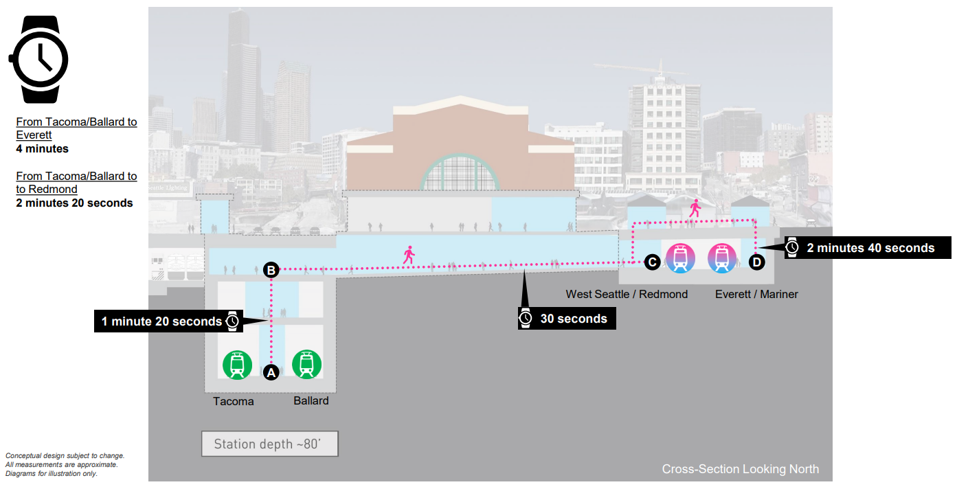
So what makes a good transfer?  Some of that is subjective – people don’t want to have to cross the street or get rained on in the process, but most of it is objective:  How fast can I get to the platform with the other train I need to catch?  Anything over three minutes for an average rider is too long: after making it to the platform you still have to wait for the next train. Getting from one line to another has to feel as close to seamless as possible.

ID Station

Of the ID station options presented in the Draft Environmental Impact Statement, only two seem to be worth further discussion: 4th and 5th Avenue “shallow.”  As we noted in our deep stations post, we were disappointed to see that shallow doesn’t actually mean shallow – it just means less deep than the absurdly deep options.  Sound Transit excluded a real shallow 5th Avenue option from consideration in a previous analysis phase due to construction impacts and considered a shallow 4th station too risky due to proximity to the existing DSTT.  Not having either option to discuss or recommend at this phase is a major miss because rider experience matters and shallow stations provide the best rider experience possible.

Of the “shallow” options presented, 4th seems to have the most potential. It could be a real transportation hub located between the existing ID station and Sounder/Amrak with direct transfers from buses on 4th Avenue. It also appears to be the hardest to fix for riders without switching to a station design that is as shallow as the existing ID station. Very common transfers from the line that terminates in Tacoma and Ballard are expected to take four minutes. We don’t see obvious ways to speed that up but we’ll leave those solutions to engineers. Sound Transit estimates that 43% of the daily 34,200 riders will arrive via transfers. That means every minute shaved off transfer times will collectively save these 14,700 riders transferring at this station ten days, every day.

Very common transfers add four minutes to each trip. ℅ Sound Transit.  
Continue reading “ST3 Transfers Must be Excellent”

Link options in Interbay

A series of public meetings focused on limited segments of the WSBLE DEIS is underway. Those who are unable to attend can comment by email, voicemail or snail mail using this page. You can even schedule a 20-minute virtual meeting with the project team to ask questions about the DEIS in the meantime. 

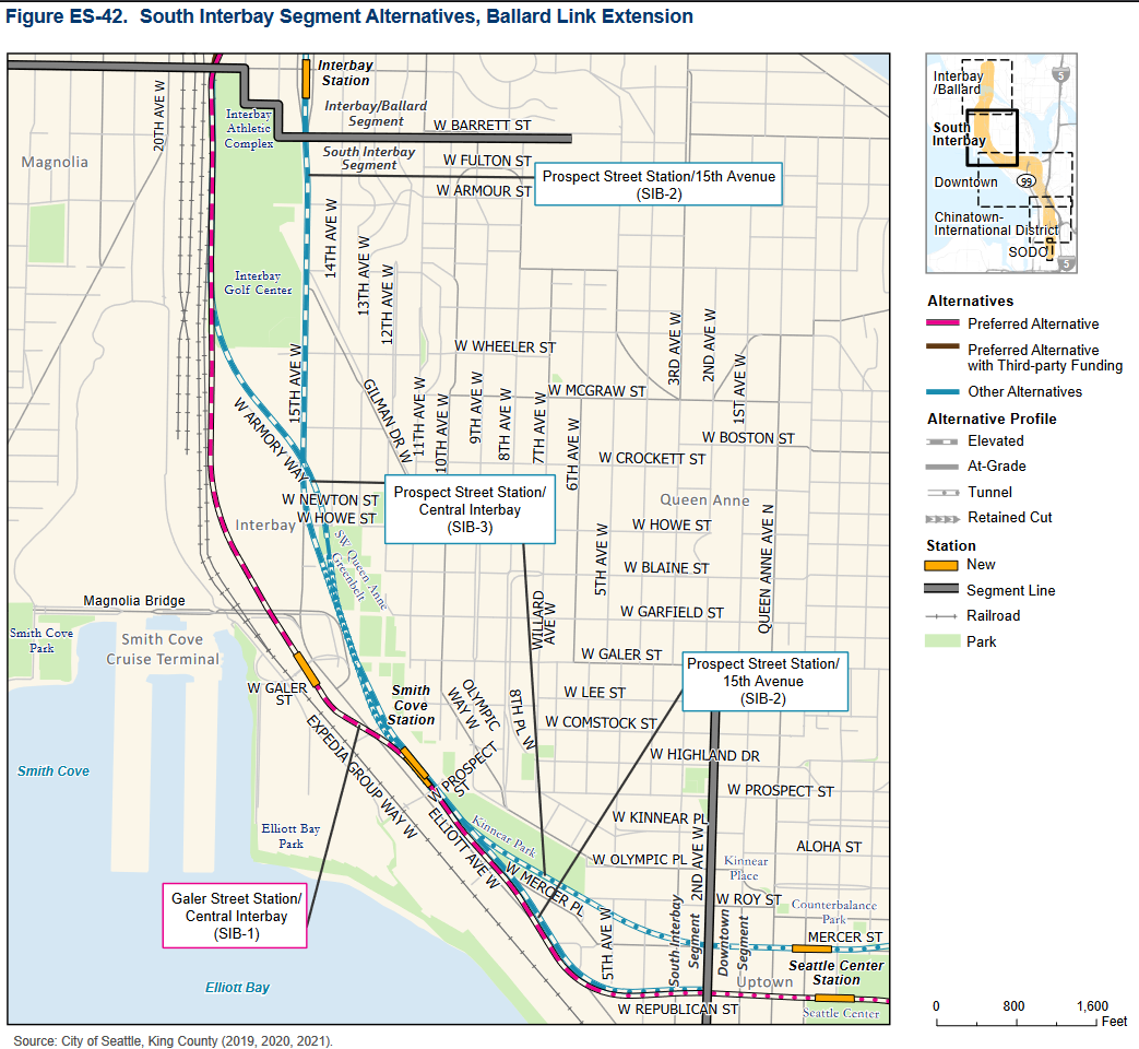
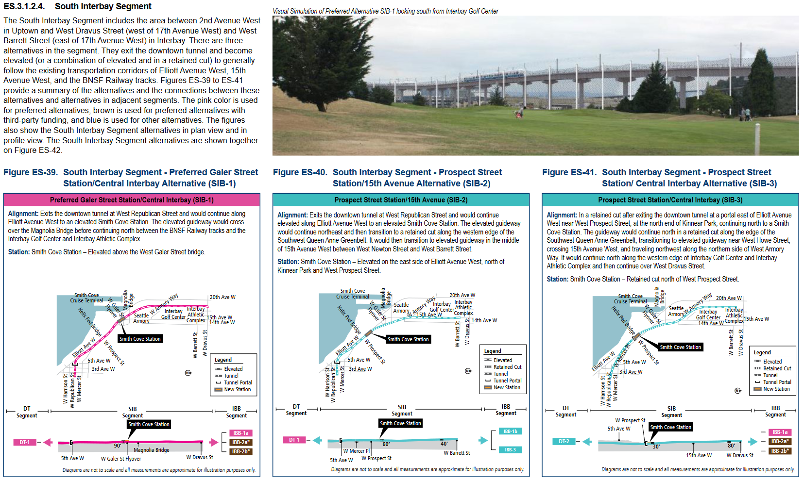
As a supplement to the previous Ballard-focused post, I wanted to include some brief details about the South Interbay (Smith Cove) segment shown below.

You can find details about each of the proposed alternatives on one page here. Key impacts such as estimated costs, ridership, displacements and disruption from construction are summarized here.

Below are some site context photos scraped from Google Street View. Note that these are the approximate suggested station locations, not the suggested station entrance locations.

SIB-1 Galer Street – Looking northwest towards Magnolia from Elliot Ave W
SIB-2, SIB-3 Prospect Street – Looking northwest towards Magnolia from Elliot Ave W

A few notes about this segment:

Continue reading “Link options in Interbay”

Are ST3’s Deep Stations a Problem?

Like most observers, we were shocked when we saw how deep Sound Transit’s station plans were for the new downtown tunnel. Beyond engineering complexity, deep stations can present a problem for riders: getting to and from the surface isn’t always easy and fast.  This concern is particularly amplified by the location and intention of these stations, downtown stations are expected to be high-ridership and a lot of trips will be short. 

Before the pandemic, a large portion of trips in the current Downtown Seattle Transit Tunnel (DSTT) both started and terminated in the tunnel.  We would expect demand for these kinds of trips to be even higher when the new ST3 tunnel opens, which adds high value tunnel destinations at Denny, South Lake Union, and Seattle Center. That demand might look elsewhere if the rider experience is bad, adding 5 minutes to both sides of a short ride just to get to the platform doesn’t really make sense for riders. The scale of the investment detaches from the utility of the infrastructure.  In short – this tunnel is very expensive and better be very good too.

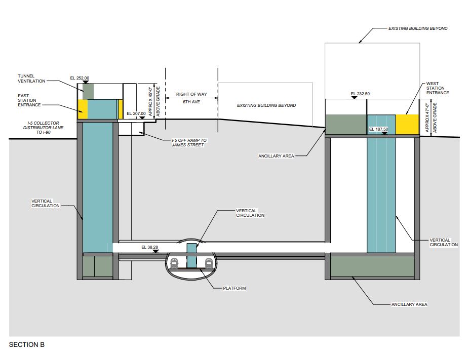
So, is it possible to have deep stations but maintain a good rider experience?  The center of this issue for riders is about speed and reliability to get to and from the train platform.  The depth of the station isn’t an issue if you and 200 of your fellow riders can get from the platform to the surface in a couple of minutes.  That means that escalators are pretty much out as a primary means of getting people in/out of a station that is over 100 feet deep. Sound Transit’s DEIS presented the following depth options for each station: Midtown:  140-190, Westlake: 125-140, Denny 100-125, SLU 85-120, Seattle Center 85-120.  That means it’s very likely that every station in the new DSTT would fail riders if the primary conveyance is escalators.  


  Midtown station, ℅ Sound Transit.  Riders are skeptical.  

Continue reading “Are ST3’s Deep Stations a Problem?”

ST3’s Ballard Station Has to Serve Ballard

As we review the Environmental Impact Statement (EIS) results as presented by Sound Transit, the decision to cut out all the central Ballard station options stands out as a huge mistake. There is only one Ballard station in ST3 and we have only one chance to get this right. We need a Ballard station where it will serve people who live in and visit Ballard:  20th and Market, directly in the center of the urban village.  

A place is not defined by its largest intersection. The EIS includes two station location options, 15th and Market and 14th and Market. Though a station at 15th and Market is marginally better than a station at 14th and Market, neither serve the entertainment district on Ballard Avenue well or maximize usability for most people who already live in Ballard. The forthcoming Ballard station doesn’t need to rely on new transit oriented development; there is already an urban neighborhood there in need of transit service already  – this must be development-oriented transit.

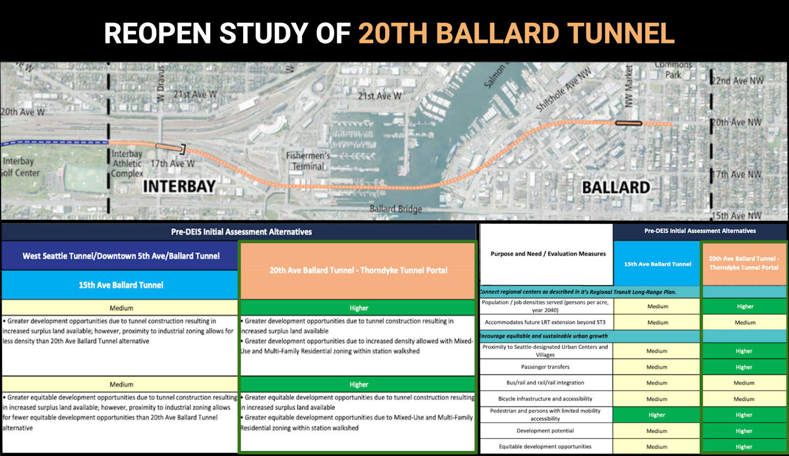
The good news is that Sound Transit studied the 20th tunnel option during Pre-DEIS work and discovered the obvious:  A 20th Avenue station performed significantly better for riders than the other options presented. The bad news is the station was cut from consideration before the EIS process for cost reasons. But an interesting thing has happened since then: the EIS analysis brought cost parity between elevated and tunnel options in Ballard. An elevated 15th station with a drawbridge now costs the same as a 14th tunnel now.  Would that cost parity extend to a 20th station?  It might. We need Sound Transit to go back to the drawing board and find out, because the difference for thousands of daily riders is significant.

20th is much better than 15th for riders (and 15th is better than 14th.)  
Continue reading “ST3’s Ballard Station Has to Serve Ballard”

WSBLE Deep Dive: Interbay and Ballard

It’s busy season for transit news around the Sound. Amidst the numerous announcements of late (zoning reform, East Link, state funding, oh my) the most concrete development has been the release of Sound Transit’s Draft Environmental Impact Statement (DEIS) for the West Seattle/Ballard Extension (WSBLE). 

With the comment period now open and several virtual public meetings scheduled, we can focus on the proposed alignment. This material is intended to arm prospective attendees of these meetings with, at the very least, a general understanding of the options on the table.

This post will be the first of several in a “Deep Dive” series. Today’s will be “Interbay/Ballard focused”, to match the subject of the first public meeting being held on March 15th.

Sound Transit granted each alternative a memorable label; the preferred alternative for this section is “IBB-1a”. We can refer to this as Alternative 1a. 

https://live.staticflickr.com/65535/51873874628_7303e87391_c.jpg

Continue reading “WSBLE Deep Dive: Interbay and Ballard”

Improving Metro 40 and D

by ROSS BLEAKNEY

The Seattle Department of Transportation has begun work on making Metro’s route 40 faster and more reliable. With these changes, Metro can substantially improve the transit network in the north end if it alters two very popular routes.

Improvements for the 40

The 40 is often delayed around the Fremont Bridge. It isn’t the bridge opening itself that causes the big delay, but the traffic that backs up behind it. The 40 also experiences congestion close to downtown as well as around Market Street in Ballard. Fortunately, plans by the city address all of these delays and more. Buses will be able to travel in their own lane, avoiding the worst bottlenecks. Not only will this make the 40 substantially faster, but it will make it a lot more reliable. With this increase in speed and reliability, Metro could reroute the 40 and Rapid Ride D in the north end, like so:

Continue reading “Improving Metro 40 and D”

Intercounty Routes for Lynnwood Link

by ROSS BLEAKNEY

The bus routes that are north of Seattle will change after Lynnwood Link. Several routes cross the county line, or should. These are operated by King County (Metro Transit) or Snohomish County (Community Transit). What follows is a proposal for changes to these routes. This is not meant to be a comprehensive list of bus routes that go across the border, but a few that would change because of Lynnwood Link.

About the Map

You can see a full size map by clicking in the corner. You can highlight a route by selecting it on the legend or the map itself. I’ve tried to be as detailed as possible on the map, although errors are inevitable (please notify me of mistakes via the comments).

Routes

Swift Blue Line

Continue reading “Intercounty Routes for Lynnwood Link”