As the public comment window for Sound Transit’s West Seattle Ballard Link Extension draft environmental impact statement (DEIS) comes to a close, it’s time to make your voice heard about what will be built as part of ST3.
As always, powerful stakeholders who do not prioritize transit quality are very well represented in this process – we need your voice to make sure that our leaders hear from future transit riders. When evaluating options, we focus on what will be best for transit riders: reliability, expandability, and accessibility.
There were a lot of surprises in this round of Sound Transit planning. Some of them were positive, such as options in West Seattle that seem to address both community and transit riders’ concerns, and cost parity between elevated and tunnel options in both Ballard and West Seattle.
Some surprises were cause for alarm, such as deep stations, slow transfers, and lack of options that serve Central Ballard and South Lake Union. Sound Transit made significant steps during this round but still has a long way to go. Sound Transit needs to study more options; because of that, we are not ready to recommend specific options for every alignment and station presented. After reviewing the draft plan, these are Seattle Subway’s recommendations for giving feedback on Sound Transit’s DEIS.
BALLARD:
Sound Transit must reopen study of the Ballard 20th/Thorndyke Tunnel Portal option. The other DEIS options fail to serve Central Ballard and are hemmed in by industrial zoning that is unlikely to change. Ballard doesn’t need to rely on Transit Oriented Development to make a station work; it already boasts a desirable, populous urban destination. Ballard’s biggest and most productive small business strongholds along 24th and Ballard Avenues aren’t moving. This station is the only Ballard station in ST3 and is likely to be the furthest west Ballard station in the system forever – Sound Transit needs to get it right.
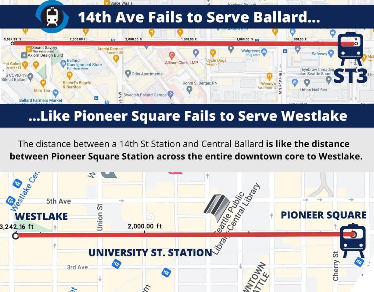
Neither 14th or 15th serve Ballard well, 20th Avenue is in the center of the urban village
Recommended Feedback: Open additional study of 20th Avenue Station/Thorndyke Tunnel Portal alignment.
INTERBAY:
Interbay Station must be built to ensure a tunnel is possible to a 20th Ave NW Station in Ballard. As such, we prefer the Thorndyke Retained-Cut station option.
Beyond making a 20th Ballard Station possible, Thorndyke Retained-cut is excellent on three important fronts: a shallow station that provides quick station access for riders, good TOD potential, and perfect location for great bus transfers from both Magnolia and North Queen Anne/Seattle Pacific University.
Recommended Feedback: Support Thorndyke Retained Cut [IBB-2a/IBB-2b].
SMITH COVE:
Like Sound Transit, we also prefer the preferred Galer Street Station option. It offers the most direct pedestrian connection to the Ferry Terminal and Elliot Bay Trail (but we’d like to see pedestrian connections further improved), the best location to connect with buses from West Magnolia, and a cool $200 million in savings over the other options. Currently it lacks the most direct access to Expedia’s campus, but building a strategically placed pedestrian bridge would bring riders to Expedia’s true campus front door in a way the other options never could.
Recommended Feedback: Preferred Galer Street Station/Central Interbay [SIB-1].
SEATTLE CENTER STATION
At 110 feet deep, the proposed Mercer station is just too deep. Though the 85 foot deep Republican Street proposal isn’t ideal, it’s not so deep that properly operating escalators would fail riders like a Mercer station would. Arts stakeholders representing the likes of KEXP, Seattle Rep, Intiman Theater, and Macaw Hall/PNW Ballet have expressed strong opinions against Republican Street station due to long construction impacts and tree removal along August Wilson Way. We want Sound Transit to further review if there is a way to mitigate these impacts while primarily focusing on serving future transit riders as well as possible.
Recommended Feedback: Prefer Republican Street Station and work to mitigate impacts to arts organizations as much as possible.
SOUTH LAKE UNION (SLU)
Neither SLU station option serves the neighborhood well and the Mercer Street option isn’t even in SLU at all. Failure to locate a SLU station as advertised to voters in 2016 within the neighborhood boundaries could even be considered grounds for transgression against voter promises. Luckily there is a better option that serves SLU and will likely be cheaper and faster to build: Westlake Avenue.
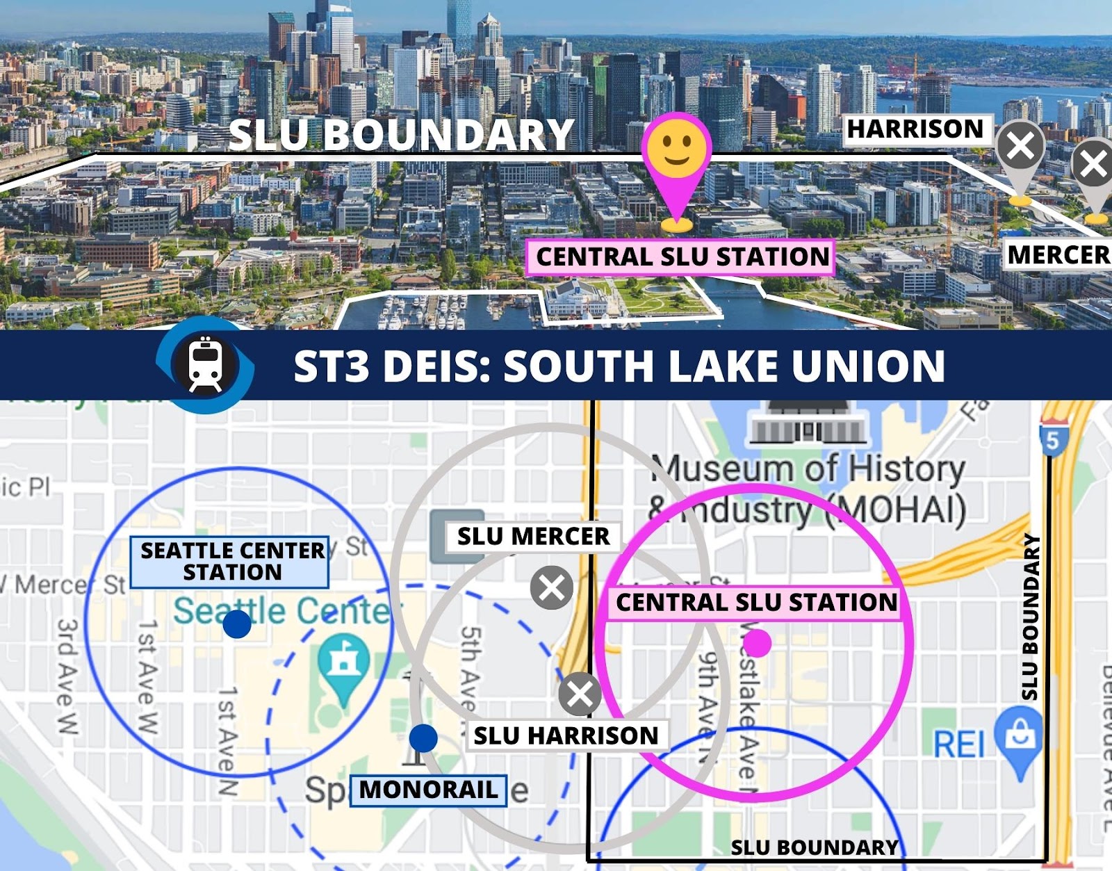
SLU station needs to serve SLU
Keeping the station on Westlake Avenue in the heart of SLU will enable a shallower crossing of SR-99/Aurora Avenue without the negative implications of a station there. A north/south station would make building for expandability easier as well. We’ll leave it to Sound Transit to find a specific solution, but a different station location that intends to serve South Lake Union is worth additional study.
Recommended Feedback: Reject both presented options, study a Westlake or similar alignment oriented north/south within SLU boundaries and as centered on South Lake Union as possible.
DENNY STATION
Tunnel Westlake Ave Station [DT-1] is the clear winner but it needs more work to become good.
Direct bus and streetcar connections, a central location, and proximal access to all of Denny Triangle including Amazon headquarters towers makes Westlake Avenue Station the best option of the two. However, the station is still too deep and overbuilt at 100 feet, which surprises us because the station lies directly under (what should be) a fairly unobstructed street right-of-way.
Recommendation: Westlake Ave Station [DT-1]. Update vertical conveyances and aim shallower.
WESTLAKE
Similar to Denny Station, one option is the clear winner but it’s still not good. Tunnel 5th Avenue Station [DT-1]. As we note in our transfers post, this station has slow transfers and detailed options for this location seem oddly under-studied for a station that expects over 70,000 daily riders.
Recommendation: 5th Ave Station [DT-1]. Update the elevator and escalator plan to improve ease of use and redundancy and additional find ways to speed up transfers and surface access.
MIDTOWN
Midtown Station is so deep (between 140 and 170 feet) that making it useful will be a challenge. A station in this location needs to be just as good for short trips within downtown as it is for long distance commuting. Our deep stations article notes that stations over 100 feet deep need to use fast elevators that skip mezzanine transfers and go directly to the platform surface. Sound Transit responded in a blog post that direct station access isn’t possible due to the line being directly under 5th avenue. This seems to assume that it’s either not possible to go under buildings at this depth or the platform has to be in the center. Our follow up questions have not received a response as of this writing. What happens at midtown seems to largely depend on what happens with CID station, so our recommendations are general.
Recommendation: Make the station as shallow as possible, design station for surface to platform elevators, build in ample elevator redundancy, and use modern interfaces to ensure nearly seamless elevator use.
CHINATOWN/INTERNATIONAL DISTRICT (CID)
Chinatown/International District (CID) Station is the Puget Sound’s single most important central station for its confluence of multimodal connections and transfers. Of the options presented, the best option is 4th Avenue “Shallow Alt (CID-1a)” but we can’t recommend it due to the excessively long transfer times.
A tunnel just as shallow as the existing CID Station along 4th Ave could be the best option that gets everyone aligned. If Sound Transit can find a way to do it, it would mean fast transfer times for riders, lower impact to the community around the CID, and likely lower costs and shorter construction timelines. We implore Sound Transit to focus on finding a way to make this potential win/win/win happen at this critical transit station and regional transportation hub.
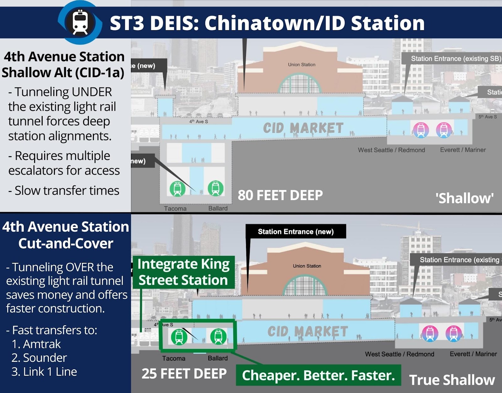
Recommendation: Prefer 4th Avenue Shallow Alternative (CID-1a) alignment but it needs to be as shallow as existing station, study a shallow cut and cover option over existing Downtown Seattle Transit Tunnel.
SODO
We prefer Mixed Profile Station (SoDo-2) for its preservation of the SoDo busway (50-70 buses/hour), lack of an awkward car overpass, and legible direct transfers for all riders. However, we want Sound Transit to study a Mixed Profile Station further north at the existing SoDo Station location to prevent demolishing the Post Office at great added expense.
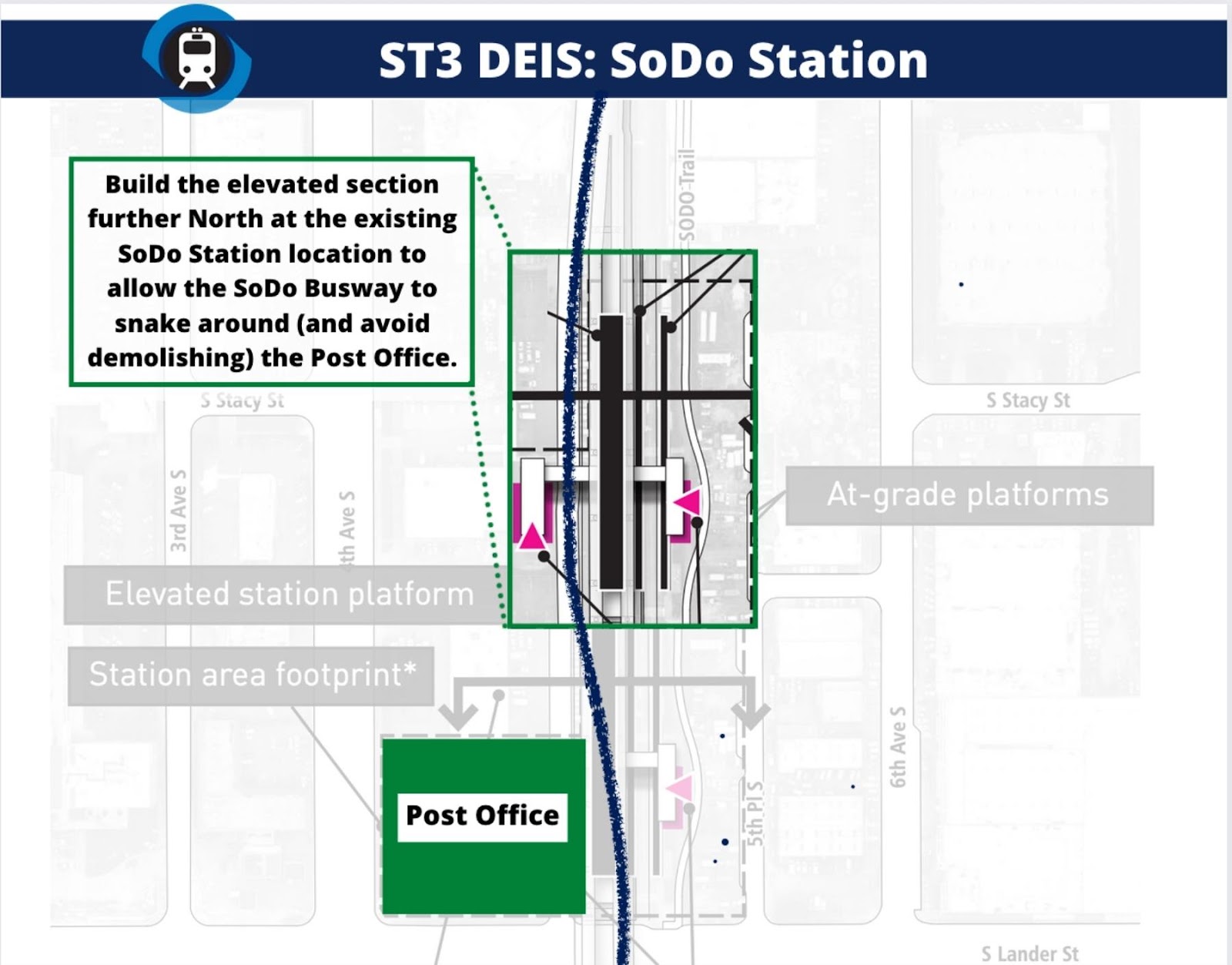
Recommendation: Choose Mixed Profile Station [SoDo-2] and study construction further North at the existing SoDo Station location.
WEST SEATTLE (DELRIDGE, AVALON, AND ALASKA JUNCTION)
We are only discussing West Seattle’s three stations in one section because of the great degree to which each station directly affects what’s possible for the other. Alaska Junction affects Avalon specifically and Avalon affects Delridge specifically.
When it comes to the Alaska Junction and Avalon Station relationship, there is no better option than WSJ-5 41st Ave Medium Tunnel Option [WSJ-5]. It gives West Seattle the tunnel it wants, the centrally located stations it wants, and the shallow stations riders need – while maintaining price parity with elevated options. The only unfortunate aspect of WSJ-5 is that Sound Transit includes only one compatible option for Delridge Station: DEL-6, which is far from ideal. DEL-6 abuts a large steel plant and offers mediocre bus connections. Bus connections are perhaps the single most requested feature of a Delridge Station and must be excellent.
With a fresh crack at this engineering challenge, we are confident Sound Transit can finagle more and better options for Delridge than DEL-6 alone that can be compatible with WSJ-5.
Recommendation: Choose WSJ-5 with a request to study better DEL-6 that are compatible with WSJ-5.
General DEIS Feedback
Recommended feedback:
- Do not eliminate any stations.
- Work to make stations as shallow as possible.
- Improve transfer times wherever possible.
- Ensure escalators and elevators are (1) fast and (2) have enough redundancy to handle game day rushes and not fail riders in the event of failure.
- Use fast surface-to-platform elevators (no mezzanines) when stations are more than 100 feet deep and align station design so that it’s possible.
- Plan to build for future expansion in Seattle.
That wraps up our recommendations for this phase of the DEIS. We again implore transit-focused community members to give Sound Transit your feedback. Your efforts are essential to building a system that works for riders. We’ve created this easy to use Action Network form if you want to echo our comments or even if you just want to use our comments as a starting point. This is a critical moment and we’re still hopeful that Sound Transit can rise to the challenge and design a system that lives up to the promise of ST3.
If we must continue with this farce that Sound Transit cares about riders, and finds the money to build WSBLE, then all of these ideas from Seattle Subway are reasonable asks, in my opinion.
However, by it’s station placement and line routings, ST has proven that there is an agenda at the agency that does not favor riders. This is how we end up with super deep stations (the 2nd tunnel in seattle), stations that are inconveniently placed where people don’t want to go (14th in ballard), lines that are not built out with contingencies for future expansion (U-District station not having been built with a connection for a UW-Ballard line), and so on.
I’m not optimistic.
I’m with you, jas.
ST’s Board is made up of political bobbleheads and large populations of the county aren’t represented, most glaringly Renton and Kent, both with populations over 100,000. This leads to “group think,” where everybody follows the loudest and strongest political voices, who in turn march in lockstep to their campaign contributors. There are few if any regular and seasoned riders on the Board, i.e. riders who have to regularly transfer, alter their planned routes, etc.
That was true for a long time but Renton is now represented by Ed Prince.
You are unaware of the HUGE concrete pour under the building looking like a pencil into the ground with that central pedestal. That building has more concrete than the pour under the Space Needle so it doesn’t blow over in the wind or rock over in an earthquake. The tunnel must go under it. Hence, why the tunnel is that depth. No choice. Now that you know, your not first pursuing why they are going so deep hurts your image.
If you’re talking about Rainier Tower, it does indeed have a massive concrete ‘counterweight’ underneath it to balance the unusual shape – it tied up just about every concrete truck in the city for days in the 1970s when they did a continuous pour to lay it. I don’t think it’s particularly deeper than the underground garages and basements under most of the buildings along 5th though.
But surely the concrete doesn’t extend underneath 5th, does it? If so, this is a non-issue.
Eliminate the Avalon station. And tunnel to the 41st area and put one station. It’s close enough for Triangle residents and Junction residents. Plus keep that monstrosity that is an elevated track down under the hill at Genesee and Avalon.
What are those Condo and Apartment dwellers on Avalon supposed to do?? How about the massive number of commuters from Gatewood and Highpoint that would commute to Avalon on the 21 bus?? It’s not just Junction and Triangle residents commuting out of the Peninsula. Easy to say eliminate Avalon if you don’t live there or have to connect there.
Yeah feels like the transfer from 21 is being underplayed.
I’ve never ridden the 21, but wouldn’t it be easier to modify the route to fit where the link stations are, then the other way around?
The bus routes will be modified either way; but with more stations it is easier to create a better network.
It isn’t clear what to do with the 21. One option is to just send the 21 to the Junction. That’s fine, except you still need to serve Avalon. Right now they have two buses that can take them downtown. With a station on Avalon, they can walk to the train, and take that. Without a station on Avalon, things get a lot worse. I’ve mulled over various options in my head, and none of them sound good. The best thing I can come up with is to just leave the 21 alone. That means no new Link connection for those riders. The riders on Avalon get a frequency hit (they lose the C/21 combination) but at least they have 15 minute frequency to downtown.
We all remember how Metro truncated buses after UW Link, and imagine the same thing for West Seattle. It is easy to think of West Seattle Link as a “game changer” in the same way. It won’t be. Even with an Avalon Station, there are big issues with truncation, starting with the fact that nothing in West Seattle is anywhere near the destination as the UW. You can make The Junction the hub (and pretend that it is) but now you’ve got places like Avalon that are no longer “on the way”. They are if you are headed to the Junction from the northern part of the peninsula (e. g. Harbor Avenue, or the eastern part of Admiral Way) but very few people live there (which explains why service there is very poor). This wasn’t an issue with the UW, because even though the freeway buses were truncated, you still had other buses (the 49 and 70) that picked up lots of riders along the way. They managed to get very good ridership, while filling in the gaps that would occur if you didn’t send any buses from the UW to downtown. West Seattle has a very different dynamic. I don’t see how you truncate buses without hammering ridership (even if you put the service savings into increased frequency in West Seattle).
I think that leaves Metro with two paths. Either they truncate and put the savings into the system (losing ridership in West Seattle, but gaining it elsewhere) or they largely ignore West Seattle Link. My guess is they do something in between.
Couldn’t they fix that by terminating whatever bus uses Avalon at Delridge?
(I say whatever bus, because presumably the C will still exist for going all the way to Westwood Village, and it currently serves Avalon.)
Couldn’t they fix that by terminating whatever bus uses Avalon at Delridge?
I suppose. But I don’t see it working especially well. I assume you mean that the bus would go down Avalon, and then loop around and end at Genesee (https://goo.gl/maps/pecdVUwZufY2Yi3A8). You don’t actually get on the bridge, but the collector distributor that leads to the bridge. The bus would be in the lane that everyone uses before they move to the right to get onto the bridge (the far left lane shown here: https://goo.gl/maps/xNCd3PyS3aE9jjJF8). That might be OK but my guess is traffic would be bad during rush hour (the whole point of this project is to avoid rush hour traffic — throwing the buses into it would be ironic). That is more or less what the 21 does now, so I guess it would make sense for some bus to do that. If it is the 21 then without an Avalon station it would be pretty irritating (right as you are about to get on the freeway you instead go under the bridge, than loop around to Delridge, where you have to wait for the train). That isn’t a problem if you have a station at Avalon (since riders from 35th would get off by the Avalon station). Other riders (on Avalon) would just walk to the station, leaving only a relatively small handful taking a bus through that section (and most would take it away from traffic, to the Avalon Station).
Without a station though, you probably wouldn’t do that to the 21. You would instead have the 21 turn and serve the Junction Station. Some other bus (e. g. the C) would go under the freeway and then turn on Delridge. That only screws over the folks on Avalon. They can’t walk to the station (they were promised) and the bus connection isn’t good. Unless, of course, you simply kept the 21 as is, and at least gave the riders along Avalon a one-seat ride to downtown (albeit with less frequency than exists currently).
No matter how you cut it, life is worse for riders without an Avalon Station.
Unless stations are spaced further apart, having a few routes at one station exclusively is a problem. That’s because to ride between two places would require doing a bus-Link-bus double transfer unless the bus routes cross elsewhere.
For West Seattle, it may be better to structure the buses to go by just one or two stations for that reason (trips remaining in West Seattle). It may be best to even create a transit center like BTC at Delridge and/or a transit street on Alaska like Third Ave downtown.
As I see it, any bus that would stop at an Avalon Station would still need to go by another station anyway to avoid this double transfer problem. Eliminating the Avalon station may then mean a slightly longer bus ride but I wouldn’t expect Metro to skip Link entirely in West Seattle.
What you are describing isn’t really unique to Link, but the result of a network that isn’t quite a grid, nor quite a hub system either. Trips either involve a three-seat ride, or a long trip in the wrong direction. In various parts of the city, this was the case before Link, and is the case now (with Link). For example, Northgate to Phinney Ridge: https://goo.gl/maps/5CE1K62g2NfbLTw36.
Part of the problem is our geography, which doesn’t allow for easy east-west travel. But decisions made by Metro and the poor stop spacing of Link don’t help either.
In the case of West Seattle, Link could help the grid, but a lot of those improvements could happen now. The 50, for example, could connect to Link in West Seattle, and then go straight across (on the Spokane Street viaduct) to Beacon Hill, providing both feeder service and cross town connections at the same time. The 128 looks good, although I’m not sure how it is supposed to connect to Link stations. Either it detours to get closer, or riders are supposed to walk a few blocks (depending on where they put the station). The 125 could turn on Genesee, although its main Link connection might not occur until the West Seattle Junction Station (depending on where the other stations are).
But in all these cases the buses the trains don’t improve things much. For riders on the 50 headed downtown, things get worse. The transfer to the train is worse than a same-stop bus transfer, and you have worse frequency (you go from two buses to one train). Nor is moving the 50 inevitable. The issue may be less about the connection to Link (at SoDo) but other connections there. I don’t see the 128 suddenly becoming really popular just because of the new train line (the C is about as fast and frequent). The 125 could go to the Junction now, or right after RapidRide H, when the bus is as frequent as the train most of the day.
Then you have northeast West Seattle. If the 21 heads to the Junction (via Alaska) then folks on Avalon are left out. They are dependent on shuttle service, but everything to the north of them is very low density. As of right now, buses run hourly there (and don’t go downtown). Thus it is unrealistic to expect a major improvement in service along there. If there is a station there, at worst they have a long walk to the train. If there isn’t, then they likely have a walk to Genesee, then a bus to one of the stations (east or west). Maybe Metro could extend the C to go along Avalon, and layover close to the West Seattle freeway. That solves the connection problem (for that bus) and at least gives Avalon riders a connection to downtown. But it is clearly a degradation for those riders.
It also doesn’t enhance the grid (or the network in general). I could see Metro running buses all day on the eastern part of Admiral Way (where the 56/57 is) along with enhanced service on Alki/Harbor Avenue. The buses wouldn’t go downtown, but curl around, and end at the Junction. The thing is, they could do that now. Those buses could connect to both the 21 and the C, and connect sooner. Thus the prospects for routes like that actually get worse with Link (assuming either the 21 or C is truncated). They get especially bad if there is no Avalon Station, as it takes even longer to make that transfer.
This is one of the fundamental problems with West Seattle Link. In the middle of the day, there aren’t dozens of different buses going downtown (that will now converge to Link, saving a ton in service hours). There are only a handful, and “shuttle service” to those buses (e. g. the 128, or a 125 truncated at the Junction) would be better for riders now, than when Link gets here. That is because Link doesn’t go anywhere the buses don’t go. This is contrast with Northgate Link. Rides on the 345/346/347/348 have improved not because Link is faster to downtown than the old 41 (it isn’t) but because of all the places it goes to along the way (Roosevelt, UW, Capitol Hill) and the fact that it goes to those places much, much faster than before. In contrast, all the significant new destinations for West Seattle Link are beyond downtown — trips they can make now, roughly as fast.
West Seattle Link doesn’t add new stops along the way, nor does it come with the potential for huge amounts of service savings. It won’t result in a big improvement in the network in West Seattle, and things would be even worse if there is no Avalon station.
As tempting as it is to change an alternative, the task at hand is to propose a mitigation as a response to a negative environmental impact.
For example, saying how moving platforms to be less deep is a good thing but it has to be presented as a mitigation. At CID, the deep platforms will add several minutes to the existing trip to travel to SE Seattle where many Asian businesses and residents are. Plus, it reduces the productivity of the line as riders will seek other transit routes rather than use the line.
I’m glad to see Seattle Subway focusing extensively on vertical movement including redundancy and sufficient capacity. This has been the major blind spot in ST station planning and even though it’s a major topic with Advisory Groups I’ve yet to see any quantitative design requirement changes proposed by ST. The result: if a trip requires using 8 escalators and ST has only a 95% operating standard, one escalator can be out of service a third of the time (.95^8) and their standard would be met. Unlike aerial stations, the subway station walls are generally fixed when built so this has to be considered NOW before designs go any further. It can’t be patched in later once construction has started or especially when the station is opened.
This impacts travel times, accessibility beyond wheelchair use, needed station footprints, people congestion in front of elevators and escalators (a topic that seems to be missing from the DEIS but if someone can find it, let it be known), maintenance costs and a host of other negative impacts.
Does anybody really believe the ST Board is going to “break the bank” and redesign any of those deep tunnels into something more user friendly? And if ST isn’t willing to move on to something more user friendly, then what?
Right now I’m seeing a system that gets less and less user friendly and as a result, carries less and less riders. Is there any room for growth in the future here? Why even build it all?
I believe that transit needs to done right, or not at all. Transit critics try to lobby for “cars first” changes that make the system not work, and then use the fact the transit system doesn’t work as a reason not to invest in future transit. Are those deep stations the end of the line for ST?
Why should more user-friendly designs be more expensive? The main impact of convincing ST to study further alternatives would be to delay the final EIS and thus the opening date. The cost of planning is minuscule compared to construction, so let ST spend a but more money and time on planing to get this right. WSBLE is so far in the future it’s irrelevant to people’s near-term mobility needs, and we’ll soon have ST2 which will make overall mobility better. We need ST to study good alternatives and give us a cost estimate; then we can determine whether they’re too expensive or not.
Continued from Mike Orr’s thought:
And let’s not forget that rapidly finishing a line that doesn’t accomplish the mobility goals is a waste of time and money.
If the goal is to rapidly build something that doesn’t accomplish much, they could build Issaquah-Kirkland first.
“If the goal is to rapidly build something that doesn’t accomplish much, they could build Issaquah-Kirkland first.”
The question is what makes the Issaquah to S. Kirkland project (don’t forget the “south” Kirkland part of the line because that is critical to understand) a line “that doesn’t accomplish much”?
First, it is the number of likely (actual) riders, and of course that depends on population density, alternative transportation modes, and the general demographic and whether it fits transit, which all determine ridership.
Second, it is dollar per rider mile.
Issaquah to S. Kirkland is estimated to cost $4.5 billion, in part due to much of it running on the surface in public ROW’s, like most of East Link, which cost around $5.5 billion from Redmond to the Mt. Baker tunnel.
Population density in this area is poor, and first/last mile access either by park and ride or nothing (trying walking Issaquah sometime). The area is not interested in changing its zoning so ST can manufacture its ridership estimates, and the two termini — Issaquah and Kirkland — are not interested in having surface rail access their core downtown.
The demographic is heavily car oriented, and the demographic — women and families — will always make driving the favored mode. I-90 is a very good freeway (although the westbound exit onto 405 north and south needs to be fixed). There is nothing in Kirkland (let alone S. Kirkland) that is not available in Issaquah, and the light rail line will access 112th, not Bellevue Way (although the subarea has the funding — and always did — to run a tunnel under Bellevue Way for this line).
So yes, every way you look at it the Issaquah to S. Kirkland line is bad transit and bad transportation funding, but ST thought it was necessary to pass ST 3 which was necessary to complete ST 2. Fair enough, but still that doesn’t mean ST should not revisit this admittedly poor line, and really cancel it. Everyone agrees on that.
So tell me what is different between the Issaquah to S. Kirkland line and WSBLE, except WSBLE will cost somewhere between $12 and $20 billion, and the eastside subarea can afford the Issaquah to S. Kirkland line (without subsidies from the other subareas even though it would be defined by some as a “shared regional facility” because “anyone can use it”).
Even if ST could roll over the stakeholders and do cut and cover, or shallow stations, or cut stations, or all surface like the Issaquah to S. Kirkland line, the ridership and dollar per rider mile will end up similar to the Issaquah to S. Kirkland line, because both projects were just transit porn to get those areas to vote for ST 3, hoping there would be a ST 4.
If WSBLE is surface West Seattle and Ballard won’t place the stations in their downtown cores, just like Kirkland, Issaquah and Bellevue will/would not. Transit ridership looks like it will decline (nationwide) due to WFH and other factors like lack of congestion. ST also has a very poor model to enforce fare recovery, so it won’t be able to afford to operate what it builds.
My guess is if both the Issaquah to S. Kirkland line and WSBLE were built the dollar per rider mile cost would be equal or better on the Issaquah to S. Kirkland line because of the enormous cost of WSBLE, no matter what the route is. The only thing driving WSBLE right now on this and other blogs is ideology, and that light rail (and subways) are somehow an inherent good even if you build it in the wilderness so dollar per rider mile like Voldemort is something that is never mentioned.
If I did not think there are so many better places to spend $20 billion in N. King Co. on transit (and non-transit like housing), and if my subarea was not supposed to contribute to something as ridiculous as WSBLE (a luxury N. King Co. residents have when it comes to the Issaquah to S. Kirkland line) I guess I could just sit back and watch ST and some transit folks in Seattle do something incredibly foolish, which of course will exhaust any other transit funding with the necessary SB5528 levy, something I don’t think SS understands.
A lot of ink has been spent arguing about station location, tunnel depth, access, route, stakeholders, etc., but way too little about mode. The cost of light rail for WSBLE just will never pencil out, because the dollar per rider mile is so bad, probably worse than the Issaquah to S. Kirkland line.
[deleted]
DT, I would walk from the Highlands P&R to Issaquah TC all the time when I lived in North Bend. I went from City Hall to the TC even more frequently. Issaquah is quite walkable, honestly.
That’s a hike, A Joy! I agree Issaquah is very walkable, generally has good sidewalks and lots of great trails. But the Highlands down to the valley floor is a haul given the elevation difference, I’m impressed. Only time I’ve done that walk is when I wanted to get some exercise.
It’s only three miles. I used to walk longer than that for fun before medical conditions sidelined me. My personal best was Big Si and Little Si on the same day back to back, Little first.
Off topic now, but Little Si is a nice little gem. For a while I felt like it was the best spring hike in the area if you didn’t want to be on snow. It isn’t too hard, nor too crowded. There are some good ones up the Middle Fork that are similar, and now are a pleasant drive (instead of a potholed mess). Trailhead Direct serves Little Si, which is a nice bonus (I don’t think the bus ever went past Mailbox Peak). Thus Little Si may be the best little transit hike available (not counting Discovery Park).
The push for a better CID station is warranted, and 4th Avenue seems to be the best fit. One addition: Run the pedestrian connection from the new line _under_ the existing platform at the current station to improve transfers. A quick transfer that connects N and S platforms at ID is a major oversight.
To build on Jack’s point, it’s important to note that the under track pedestrian connection was presented to the committees in 2018, as shown here:
https://www.soundtransit.org/sites/default/files/project-documents/west-seattle-ballard-stakeholder-advisory-group-meeting-presentation-20180716.pdf
ST has not explained why it went away. Such a connection was fundamental to promoting transfers at CID. It’s like being sold a vehicle with promised features and having them not provided after you agree to buy the car.
I’m still concerned about 4th Avenue’s limited walkshed. 5th Avenue has a lot of retail and job destinations on both sides, and is closer to the continuous density up to Little Saigon and Harborview. On 4th Avenue the entire western side is taken up by the train tracks and King Street Station, and I doubt BNSF would consider TOD above the tracks and platforms. On the eastern side is the Union Station offices, but those are just as close to a 5th Avenue station. So 5th Avenue has a better walkshed. Transfers to Lines 1 & 2 seem similar in either case. Amtrak and Sounder have only a few runs per day, so most of the time nobody is going to them. Pioneer Square is already served by Pioneer Square Station. So the 4th Avenue alternatives seem less good for overall transit mobility.
Mike that’s a good point. Although one could argue that the transfer potential at 4th offsets any loss walkshed compared to 5th. Plus, if the pedestrian underground was done in an accessible way it may not matter much.
Plus there is construction happening in pioneer square and 2-3 story buildings are becoming 8 story residential with ground floor retail.
Since 4th has to get rebuilt anyway …
I believe there’s a plan in the works to cap and redevelop a section of the train tracks
Sounder should grow to something closer to all-day transit, so it will become a more important transfer in the future. Same with Cascades, presumably that will run much more often in the future.
“if the pedestrian underground was done in an accessible way”
Ha ha ha ha ha.
They’ve built quite a lot of stuff south of King Street and north of the stadium, so it’s a bit better than it was. Still an awful lot vacant.
In terms of prioritization, having a shallow station at CID strikes me as a more urgent than going shallow at midtown. CID is already a big transfer point and will grow in importance in that role – easing those transfers is important, while the use of the line as an intra-downtown mode is ‘eh’ at best. I just don’t see the use case when the wait time for a crosstown bus on 3rd is shorter than it takes to even get into an underground station.
We definitely agree. Getting CID right is absolutely critical. What is possible with midtown is largely dependent on design choices elsewhere, though if it’s going to be deep it’s important that people can get to the platform fast.
ST still hasn’t provided a good reason why they can’t have a shallow(er) station at midtown though. If the only issue is the slop coming up from CID a shallow 4th should fix that as well.
Not sure if anyone from Ballard Subway has ever been to West Seattle, if they did they would probably get lost trying to find the “large concrete plant”.
Anyway, the station options are not nearly as interconnected as this article would make it seem.
I agree that the 41st Ave tunnel station is the best option for the Junction. If we accept that as a recommendation, they can still select any of the three Delridge station options. Out of those, the lower-height Delridge options (Dakota or Delridge Way) + routing along Genesee to reach the Junction are far superior to the Andover location.
The Avalon station does depend on those two decisions combined, but Avalon deserves to have the lowest priority given the low projected ridership and the greater importance of the other two stations (Junction being in the urban village and Delridge being critical for bus transfers and for the racial equity toolkit.
Given the above, the preferred tunnel underground Avalon station is a really great fit. It has broad support in West Seattle. Similar to many other decisions, it appears to be too expensive. So I would argue that the best choice of action would be to find the money to build it now. The second best course of action is to skip it, since there are a large number of higher priorities elsewhere.
I think the other factor working against the Avalon station is that it doesn’t have a rapid ride transfer like the other two stations and the 21 bus could easily turn from 35th onto Alaska to reach the 41st tunnel station without any delays.
ST specifically identifies only one Delridge option being compatible with the 41st Medium Tunnel option. Other than that, it sounds like we agree. If they can improve the Delridge site there is a clear winner.
We’ll fix the issue with the concrete/steel. Missed that on our edits, luckily it doesn’t change the point at all.
Thanks for the reply!
If they go with the Andover-Yancy routing (Medium Tunnel) then they are locked into the Andover station location or something similar (the CAG was shown a slightly different version this week that was essentially in the same location, maybe a quarter-block farther south).
I’m referring to WSJ-3a (41st tunnel) which can be paired with DEL-2a, DEL-2b, and DEL-4.
If they skip the Avalon Station, it is likely they can reduce the depth of the 41st station to something closer to the medium tunnel.
In the land of alternative universes called ST, they presented an enhancement to the Delridge station last night: A pedestrian bridge for Andover. Not Delridge but Andover.
We could still skip or defer Avalon Station as long as the 21 can get to either the Junction or Delridge stations with little delay. Since there’s only six blocks between them, that doesn’t sound like much overhead. Going to the Junction would have the added benefit of connecting 35th to West Seattle’s main village. West Seattle has a problem with north-south barriers isolating California, 35th, Delridge, and 16th into islands, so it’s easier to get to downtown than to other parts of West Seattle or its main village. The 50 now goes east-west, but most of 35th and Delridge are not in walking distance of it, so they’d have to do a short transfer or walk up a steep hill, or more likely just not go there, which fragments West Seattle. So anything we can do to improve that would be great, like sending the 21 to the Junction.
Yes!! The Thorndyke portal option is by far the best for Ballard!!!!
Thorndyke is a non-starter because it requires going DEEP below the new, massive storm-sewer storage vault, and would require some very expensive takings/displacements along 20th Avenue to get enough work area to launch/catch TBMs. I don’t understand how people keep missing this.
https://spushipcanal.participate.online/
I have not been a proponent of any Ballard alignment, but high capacity is best when its stations serve pedestrian centers.
So, there is to be an SPU vault in the longitude of 20th Avenue NW? See link. What is marginal cost difference between the TBD launch parcels for the several alignments? Could not significant redevelopment be done on a conceptual 20th Avenue NW launch parcel? Some of the corridor has not yet been redeveloped. How much better would a 20th Avenue NW alignment be than a 14th Avenue NW alignment? (The likelihood of further expansion seems very slight). The large hurdle at the moment is ST inertia toward the alignments in the EIS.
I’m not saying that the station shouldn’t be at 20th (or anywhere other than the core of Ballard) but I think that if people are going to comment that ST should re-open study of the various tunnel alternatives west of Ballard Bridge, they should review the stated reasons those alternatives were screened out in the first place.
I’ll repost my proposal for what I believe to be the most reasonable way to get the Ballard end of WSBLE to the walkable core: https://www.google.com/maps/d/u/0/edit?mid=1QlgnP_qYdEvfaePOKmh3wk8SfYve5Obe&usp=sharing
Screening process is documented in the DEIS here: https://www.soundtransit.org/sites/default/files/documents/13-wsble-drafteis-appendixm-alternativesdevelopment-202201.pdf
What puzzles me is why ST didn’t consider any east-west oriented station options in Ballard after working with the City to study the Ballard-Downtown corridor in 2014 (https://www.seattle.gov/Documents/Departments/SDOT/About/DocumentLibrary/Reports/B2D_FinalReport%2005-16-14.pdf). The armchair assumption is that ST wants to maintain compatibility with northward expansion, but in preparation for the ST3 vote, ST’s long-range planners studied and eliminated extending light rail north of Ballard while keeping Ballard-UW and southward extensions of HCT from Alaska Junction. So, if ST doesn’t think northward expansion beyond Ballard is worthwhile in the LRP, why force all possible alignments to point due north?
“if ST doesn’t think northward expansion beyond Ballard is worthwhile in the LRP, why force all possible alignments to point due north?”
EXACTLY! If there is a reason it has to point north we don’t know it because ST has NEVER studied any other options.
I think you have found the motivator for a north-sound station which is how the 2014 study ended at Crown Hill. It should be noted that the 2014 study was run by the City and not ST.
The irony is that we now see that surface on 15th Ave north of 57th is a non-starter and aerial probably is. Any Crown Hill extension would be very expensive without much ridership benefit — and if it’s in a bored subway, the line could have an east-west station in Ballard and the line could simply circle back to a Crown Hill station.
The refinements and cost savings ideas that staff put on the table last week are so minor that I have little hope that the Ballard station placement can be rethought. They moved 14th Ave east by less than 100 feet and didn’t even shift the platform a block southward. That meeting would have been the point where the east-west refinement would have been introduced and it wasn’t. That’s after many Advisory Committee members and transit advocates have pushed for a station at least as west as 17th. It’s clear to many armchair transit advocates that crossing around 14th with an east-west station near 20th solves a number of design and cost problems and the main disadvantage is making Crown Hill less direct.
I suspect that there are real estate and development interests looking at properties like a chess board ever since 2017. They are lobbying elected officials directly rather than floating ideas for public opinion. If it was a topic for public opinion, some elected official would already be strongly pushing for a study of an east-west station. Probably every property within four blocks of 14th and Market has some advocate walking City Hall and Dow’s office.
This point to how decisions are made in our local political system. It’s a combination of backroom lobbyists constraining creative options combined with avoidance a neighborhood uproar especially if it seems to impact a “victimized” community. Note that in all of this, riders never get respect or usually aren’t even invited to sit at the table. It’s all about real estate.
I won’t be convinced that our local political system will change until a Council candidate or executive candidate prominently proposed how to bring riders more into the process.
It doesn’t look like going further west (to 24th and around the pipe) was studied.
strangely, this link says ST is buying the roundhouse between 18th and 22nd, which would’ve permitted surface running to gilman pl and 24th.
https://www.trainorders.com/discussion/read.php?1,5310943
Sound Transit has/or is in the process of purchasing the property. The buildings and turntable will be torn down/dismantled.
“… with avoidance [of] a neighborhood uproar especially if it seems to impact a wealthy “victimized” community. “
Fixed it for you.
Jim C: perfect adjustment!
If CID interests cared about their community they would have instead pushed to leave the Rainier Valley Link segment (a very Asian focused corridor) stopping at the existing station rather than make its own community members use a station further away as well as deeper.
And the last uproar about subway ventilation was particularly laughable. If ventilation is an issue, build the line above ground!
You would cross the ship canal at 15th or 14th then swing west to get to “actual Ballard.” If you’re really gung-ho about TOD and redevelopment in West Woodland, presumably a (deep, like Husky Stadium) station could be added there somewhere south of Market along the way. Has anyone proposed this? Seattle would likely have to cough up a log of extra $$$, though.
[deleted]
@Nathan “ Makes future developers happy, makes “West Woodland” a “real neighborhood”.”
Yes, but if they did the crossing at 14th with a swing to an east west station at 20th they should ALSO still put a station in West Woodland, and developers still get everything they would want.
I don’t think a station to the west of 15th was shot down for some hidden TOD agenda. It think it just evolved that way. It is the way most of Link evolves. Decisions are made by board members at the time, and they are made by people with no transit expertise, and often with only very preliminary studies.
If I remember right, sending the train to 20th was rejected very early on, before they considered running the train to 14th. At the time, they were focused on cost, and above ground was assumed to be much cheaper than underground. You can’t really run above ground on 20th, which means that 15th sounds like a much more economical option. Then, of course, they looked at above ground for 15th, and saw that there were problems. People noticed all of the empty nothingness that lies to the east (at 14th) and figured that would be cheaper. People rightly complained about 14th, so the board basically said “Well, if you Seattle folks really want that station at 15th, you can pay for it yourself”. Next thing you know, we have formal studies of elevated and underground lines to 14th and 15th, but nothing to the west. Uff Da!
Regardless of the motivation, we should push hard for a station at 20th. We should make it clear that it doesn’t have to be via an underground, straight north-south tunnel. It could come in from the east, as with Nathan’s excellent proposal. It could potentially come in from the west, above or underground. This was one of the early proposals: https://www.seattle.gov/Documents/Departments/SDOT/About/DocumentLibrary/Reports/B2D_FinalReport%2005-16-14.pdf#page=59. This is an above ground route that turns and serves 20th and Market. It had a surface section through downtown, and those options were rejected for the next level of study. But it does show up as Corridor A: https://www.seattle.gov/Documents/Departments/SDOT/About/DocumentLibrary/Reports/B2D_FinalReport 05-16-14.pdf#page=77. Notice that they have both an above and underground option. In both cases they put the station at 15th, but there is no reason the station can’t be at 20th. For that matter, there is no reason the station can’t be at 56th and 20th, with the same basic idea (either above or underground).
This is the route of the problem. A station at 20th was considered early on, but never studied in detail. Everything was based on the assumption that 15th would be much cheaper, and easier. When that didn’t prove to be the case, they scrambled to find an alternative, and only worse options are now being considered.
Everything is backwards. They should have studied 20th and Market in detail. This means above ground and underground (and surface, for the station itself). They should have looked at coming in from the east and the west, or straight across. They should have looked at nearby alternatives (such as 20th and 56th). If none of those options were acceptable — if they were all too expensive, then they should have looked at moving the station farther away.
Our job is try and get ST to study 20th, the same way they should have studied it in the first place. Look at coming in from every direction. Look at above or underground (or some combination). Look at 20th and Market, or 20th and 56th. This is being done for other stations, it needs to be done here.
“Our job is try and get ST to study 20th, ”
I agree — although I think it’s almost impossible to get ST to change their alternatives.
ST tossed crossing the ship canal west of 15th for a variety of reasons. So the solution is to ask for ST to cross at about 15th / 14th but have the station at 20th.
Related to that is the station orientation. The more east-west the platform is, the closer the entrances at each end can be to the general east-west density orientation of the neighborhood. It’s worth adding that topic to the request because a reoriented station seems more useful as long as it has a west entrance west of 15th or 17th.
@Brandon – yes we had a good thread on this in an earlier post. One proposal was to settle for a station at 14th (elevated or underground), but then ensure the station was far enough south (1~3 blocks south of Market, not immediately at Market) to allow for it to swing west, likely with funding from a subsequent levy. In other words, view the WSBLE’s Ballard station as a temporary, not final, terminus.
Well thought out and articulated proposals. Having lived in Ballard for a few years, the station there makes a lot more sense over in the heart of Ballard (20th) than where the plans are directing it at present. Further, the system needs to be built for the future, which hopefully will finally see the chronically-overdue Ballard – U District line for a routing that’s been congested for over 40 years. A line connecting those two would facilitate those who commute and travel north (not everybody works in downtown Seattle) as well as those who work between the U District and Ballard. But, alas, ST’s Board is loaded with politicians with agendas bolstered and advanced by their well-heeled campaign contributors, with no day-to-day riders with a seat on the Board and no individuals or groups that I know of with any traction with the Board. I sincerely hope that I’m wrong and that the proposals of Seattle Subway and the Urbanist will see the light of day with ST’s ivory castle of planners.
I’m posting this here, because the last open thread was in late March and is now closed to comments and I’m not sure where else this would go.
Northgate, Roosevelt, and U District Link stations are all closed due to “mechanical” issues. Sound Transit is running a bus shuttle serving UW – Northgate stations, however it appears that there is very little communication about how to access the shuttle buses. And despite the lack of communication, the shuttle buses are overloaded because there aren’t enough of them.
In particular, Sound Transit doesn’t seem to realize (or care) that Metro operates several buses that serve multiple Link stations. In particular, route 67 serves all of them! Why is Sound Transit not working with Metro to have riders use both regular Metro routes and the ST replacement shuttle? It seems like a contingency that ST should have come up with after the Apple Cup shutdown.
[deleted]
The “mechanical issue” is apparently something to do with the fire detection/suppression system:
https://www.seattletimes.com/seattle-news/transportation/fire-system-glitch-closes-two-sound-transit-stations-wednesday/
I totally agree that ST should have been prepared for this, and I do wonder where the extra buses are coming from given that this is peak period and historically that means basically every bus and operator is already deployed. It seems like the contingency should be situation-normal for the 67, send the 522 down 25th to UW Station, and send the CT buses on their old campus loop route.
Ironically, this is probably the one time that the 20 makes any sense at all.
Also, why doesn’t ST list this as a service alert on their web page (https://www.soundtransit.org/ride-with-us/service-alerts)? I can see stop closures for low-ridership bus routes but not for their premier multi-billion dollar rail system. Surely this warrants an alert?
No, even with this disruption, Route 20 still makes little sense. It does not serve the UW or Roosevelt stations. It is too close to Route 62. It has one key segment: Lake City to Northgate station, formerly served by Route 75.
There weren’t any inebriated football fans to lead the way down the tunnel.
I’ll be really curious when the Board realizes when ST shifts from being a construction agency to an operating agency. Building shiny new stations is fun and brings happy public feelings, while operating is more vulnerable to criticism.
Regardless, the ST “honeymoon” is ending and it will never have the appeal as it did as it was building. It’s particularly true after 2025 when ST will then go for several years of non-openings followed by extension projects that will either be more minor (non-WSBLE) or horrifically expensive and disruptive (WSBLE). At that point, almost all news about ST after 2025 will be operational problems or construction problems and that will turn public perception (and Board perception by extension) into a more critical and realistic perspective.
The new CEO choice will say it all. Will the Board hire an strong experienced operations problem solver, a detailed rail builder manager, a silky-tongued dreamer and presenter or a quiet administrator willing to bow to Board wishes behind the scenes?
I’m just seeing this the day after, but yesterday the Westlake nothbound platform elevator was also closed (there were announcements on train and at SODO about that), and the Denny elevator at Capitol Hill was closed (no announcement).
ST always runs shuttles when there’s a lengthy interruption. It even has a Metro route number, route 97, although the buses say “Link Shuttle” with no number. The shuttle has several advantages:
1. No chance of overcrowding the regular bus routes.
2. Easy to understand for passengers unfamiliar with Metro’s routes.
3. No complication about transfer fares for people with Link-only tickets.
4. The shuttle stops only at Link stations. The 67 is annoyingly slow if you’re going from Roosevelt all the way to Northgate.
5. It’s ST’s responsibility to provide replacement service.
How are you going to explain to visitors when various segments close that route 67 serves Northgate to U-District, 45/48 U-District to UW, no route UW-Capitol Hill, 49 UDistrict-Capitol Hill-Westlake, 70 UDistrict-Westlake, 7/14/36 Westlake to Intl Dist, 131/132 Westlake to SODO, 36 Intl Dist to Beacon Hill, 106 Intl Dist to Rainier Beach, no route Rainier Beach to TIB, 124 Westlake to TIB, A TIB to Angle Lake, 124+A Westlake-airport, 67+70+124+A Northgate-airport?
I had the same thought! Perhaps the better approach would be for the ST shuttle to be just adding more busses to Route 67? It’s even possible some of those affected riders were transferring to the 67 anyway!
So the latest uproar that arose at the CID Advisory Committee meeting last night was about ventilation in Chinatown for the 5th Avenue options. The citizens were all in a snit saying that the air from the ventilation was contaminated and would cause decades of additional health problems. Staff tried to explain that it’s not ventilation for gasoline engine exhaust but just for air circulation in the tunnels but the citizens were just not hearing it.
You do get a bit of ozone from the electrical equipment, but that’s nothing that would even register on a measuring instrument at the surface, considering the amount of highway exhaust already there.
Hell, a single sheet metal shop in SoDo doing arc welding probably produces more.
Galaxy Brain idea… The city should Eminent Domain the QFC on 24th & 57th to convert to a lightrail station. It’s right by a park, library, tons of apartments, transit, Market, etc etc. Alternative option, the Safeway on Market. Same reasons. We don’t need that many grocers… take the space and use it for public good.
There’s apartments on top of the QFC and reducing our housing stock is not great for the long-term, including for walk-up transit ridership to the station. If ST is going to use eminent domain on anything, why not the empty lot that had the building that burned a few years ago at 24th & Market?
That’s all wishful thinking, though, because I think 24th is well to the west of where any of the feasible station locations are (or at least what ST thinks is feasible).
The current plans are to use the Market/15th Avenue Safeway lot for materials staging and construction, with eventual redevelopment as large-scale TOD.
The 24th and Market empty lot is too small to do anything. Besides, it’s already slated for construction starting later this year/early next year as another several-story mixed-use building.
Is there enough lipstick in the US to make this pig over? West Seattle is an enormous amount of money for very little benefit. Will Metro be able to resist demands to run parallel buses to downtown from both neighborhoods?
How about No Build, at least for now? Let North King digest the changes that North Link will bring and then decide what to do with its accumulated money.
But demand that the decisions about routing and station placement and design will be decided by North King only. Enough of these long station gaps within the City for the convenience of suburban riders.
“But demand that the decisions about routing and station placement and design will be decided by North King only. Enough of these long station gaps within the City for the convenience of suburban riders.”
That depends on whether the four other subareas are to contribute to DSTT2 or WSBLE, or some other design. If not, let N. King Co. (or at least the N. King Co. reps on the Board who may have different views depending on their district) do whatever it wants. It’s their money (kind of, unless you consider the extensions for the debt limit). My understanding, however, is the station gaps within the city are due to cost, and the fact the stations are underground and very expensive to build.
Just out of curiosity, where would you have added additional stations along Line 1 in Seattle now that the Board has greenlighted Graham St. and 130th?
Mercer Island got to dictate where a bunch of buses go because of a single station located in their city.
So I’m not sure why you would complain about a community being able to dictate how other people’s money gets spent on facilities inside their community.
“Mercer Island got to dictate where a bunch of buses go because of a single station located in their city.
“So I’m not sure why you would complain about a community being able to dictate how other people’s money gets spent on facilities inside their community.”
Glenn, I am not sure you understand my position, or the eastside transit restructure.
I am not complaining about how a subarea spends revenue raised in their subarea. However, if that subarea (N. King Co.) wants the four other subareas to contribute to DSTT2 — or some other project in N. King Co. — to the tune of $1.1 billion or more then yes, those subareas have a say in how their money is spent. In general I agree with Tom Terrific’s idea to pause WSBLE (because it is both a poor transit project based on dollar per rider mile, and because it is unaffordable) and instead use the revenue raised in N. King Co. to augment Line 1 although those underground stations will be expensive, or other less expensive transit modes, without any funding from the four other subareas.
Re: the eastside transit restructure, Mercer Island had very little to no say. It is true MI does not want the intensity of the intercept ST proposed in 2017 (right after the parties had executed the settlement agreement) but cities and neighborhoods always lobby or fight for what they want. It is why East Link runs along 112th, and Issaquah will get a $4.5 billion line.
The parties controlling the eastside transit restructure were: 1. Metro; 2. Bellevue; and 3. Issaquah, the usual suspects.
Metro is not ST. It knows it cannot possible serve/cover all of east King Co., which is why park and rides are handy, and it can’t afford ST’s arrogance to think transit can determine where people want to live and where they want to go, or to simply make up ridership estimates. So from 2016 (ST 3) to 2021 this is what Metro learned:
1. ST’s estimated ridership on East Link was so inflated it was dishonest, pre-pandemic. Post pandemic East Link might reach 50% of ridership estimates. It is pretty ironic that just a few years ago eastsiders were all worked up about capacity because East Link is limited to 8 minute headways based on ST’s 2016 ridership estimates used to sell ST 2 and 3.
2. With the rise of Bellevue and demise of downtown Seattle, and WFH, cross lake ridership will also be much lower than anticipated. Once you take away travel on East Link from Downtown Bellevue (Bellevue Way) to downtown Seattle East Link makes little sense on the eastside. From Mercer Island to Redmond, along 112th, driving will always be the preferred mode.
3. East Link runs along 112th, and few want to go to 112th.
4. Eastside transit use is peak oriented, and more commuters will opt to go to their employer’s eastside offices rather than downtown Seattle (especially if they work on First Hill or in SLU). Eastsiders drive during non-peak times, and parking is free.
5. If commuters from the Issaquah area do return to downtown Seattle they will demand one seat buses, especially to First Hill or SLU, like the 630, or like pre-pandemic dedicated shuttles from the employer.
So basically, with limited funding, Metro decided it could not afford more frequency on Mercer Island to “intercept” with East Link.
This is what Bellevue learned:
1. These workers are coming from Issaquah and Sammamish, not Renton, so having S. Bellevue serve as the intercept was ok.
2. Bellevue is building huge amounts of office space, and wants eastside workers to work there, not in Seattle, and so do the employees.
3. East Link does not serve Bellevue Way (duh).
4. Commuters from Issaquah are not going to drive to a park and ride to catch a bus to transfer at S. Bellevue to then get dropped off on 112th. At worst they will either drive to S. Bellevue and park, or demand subsidized parking from their employer. Bellevue, unlike ST, is actually trying to attract these workers, and cater to their needs.
So voila, shift the eastside workhorse, the 554, to Bellevue Way.
I would also say it is generally a bad idea to designate a major intercept at a location folks don’t go to otherwise. Mercer Island is a wonderful residential city, but few from off-Island come to MI. The commercial scene is pretty weak compared to the rest of the eastside, on purpose. The light rail station is 35′ below grade with a ceiling open to the elements, and needed a noise variance because it sits between eastbound and westbound car traffic on I-90 in a concrete canyon with eve the meagre retail blocks away. Better to just drive to the 1500 stall park and ride at S. Bellevue than bus to MI. Or directly to Bellevue Way.
The reality is the pandemic, and the decisions Eastsiders have made post pandemic about where they want to live (which includes rejecting upzoning their residential neighborhoods, which along with schools is the number one reason they are on the eastside) and where they want to work (eastside, WFH) made Metro’s transit restructure pretty obvious, along with the fact East Link runs along 112th, not Bellevue Way, and not much Metro can do about that.
So really your opprobrium towards the eastside transit restructure that I personally think makes sense should be directed at Metro, not Mercer Island, and I guess maybe the Seattle City Council for the conditions in downtown Seattle that are shifting eastside workers to Bellevue and the eastside.
Not to put too fine a point on it, Daniel, but there really aren’t that many mega towers along Bellevue Way. There are none south of Main Street, so Link traveling alond 112th to a station on 110th isn’t the dust under the rug you think it is.
Tom, 102nd or even 104th for East Link would have worked too, although Bellevue Way is the retail hub, and is developing rapidly. The issue with 112th is to the east is 405, and to the west a pretty steep hill to reach most of the office and residential towers. It would be like running Line 1 along 1st in Seattle and expecting riders to walk to buildings or shops on 5th and 6th, with no station at Westlake, the retail hub. Or putting a future stop for SLU west of 99.
Many years ago I worked at 8th and 108th in Bellevue. Bellevue at that time was pretty sterile (late 1980’s). I lived on Ravenna. Everyone drove to work. But for lunch, shopping, or dining/drinks after work we all walked to Bellevue Way, mostly to the mall since this was before the two Lincoln Towers.
The Spring Dist. and Wilburton will be able to recreate the sterile office environment of the late 1980’s but will have a very hard time recreating the retail environment on Bellevue Way. Even The Bravern never took off (in part because of the poor parking access)
The key to retail/restaurant vibrancy is retail density. So folks living or working in The Spring Dist. and Wilburton will end up going to Bellevue Way for drinks and dinner, and Bellevue Way will be the class A office space. Bellevue has always planned to run shuttles among these different areas, but they will take people from The Spring Dist. and Wilburton to Bellevue Way, not the other way around.
Or many will simply Uber, which will be cheap with two or three in the car. I really do think micro-transit for short trips is the future because it is the perfect first/last mile access (if you have the money) with Link for longer trips. https://www.msn.com/en-us/travel/news/seattle-ride-now-program-gives-free-rides-in-town-to-elderly-disabled-and-caregivers/ar-AAW6pPd?ocid=hplocalnews
Obviously, folks like the Bellevue Council and Freeman did not think East Link was critical or important to retail/restaurant vibrancy, and those two rather than transit would attract commercial/residential development, and it looks like they were right (which is why Freeman bought up so much property on Bellevue Way). I think ST made a big mistake though because the subarea had the money for a tunnel under Bellevue Way or 102nd, and will have huge amounts of ST 2 and 3 revenue left over with better places to spend it than Issaquah to S. Kirkland.
If anything I think this hurts the effectiveness of East Link for those living in Seattle. In 2004 Microsoft envisioned its younger tech employees living on Capitol Hill and catching East Link for a one seat ride to the Redmond campus, but I wonder how many employees still live on Capitol Hill as they aged and married. I am sure Microsoft was not keen on spending the money to build a 3 million sf underground parking garage when Microsoft claims it is uber green, but employees demanded the parking.
Folks from MI to Redmond will still primarily drive to Bellevue, and to Bellevue Way. Parking for the most part is free. Riders from Seattle are not going to Mercer Island, S. Bellevue, 112th, or Redmond. They will want to access Bellevue Way, just like I would want to take East Link west to downtown Seattle. So either a shuttle system or Uber/Lyft will be necessary, although most Seattleites have cars and know the parking is usually free on the eastside, and traffic today light.
The biggest issue for East Link IMO for intra eastside travel — even if it accessed Bellevue Way — is it requires a transfer or feeder bus for so much of the eastside, and eastside work commuters in the past have been reluctant to transfer (so simply drive to the park and ride that serves their one seat ride, or to their ultimate destination). I think this is the point of the one seat ride on the 554 from Issaquah to Bellevue Way, which should be very popular. Eastsiders like and tolerate park and rides, end up paying for the car and driver to get to the park and ride, and like one seat rides.
Some think mode is the be all and end all for transit. I think first/last mile access on both ends is. With HOV lane access the 554 will do everything the Issaquah to S. Kirkland Line (and virtually zero Issaquah residents will continue onto S. Kirkland) will do, cheaper and faster, with direct access to Bellevue Way.
I think if ST made one major mistake it was believing it could determine where folks want to live, work, and go, which is a tragic error if the cost per mile is millions and the line is fixed. That was an error of arrogance, and with the eastside transit restructure I learned Metro does not feel it has the funds or ability to afford that kind of arrogance. Metro just tries to figure out where riders want to leave from and where they want to go, for whatever reasons, and hopes the funding is there to cover some of it in east King Co.
Daniel, the station is at the corner of 110th and NE Sixth, at the top of that “steep hill”. It isn’t GREAT there — it would have been better under 110th — but it’s not on 112th.
> If anything I think this hurts the effectiveness of East Link for those living in Seattle. In 2004 Microsoft envisioned its younger tech employees living on Capitol Hill and catching East Link for a one seat ride to the Redmond campus, but I wonder how many employees still live on Capitol Hill as they aged and married. I am sure Microsoft was not keen on spending the money to build a 3 million sf underground parking garage when Microsoft claims it is uber green, but employees demanded the parking.
Unless Microsoft stopped hiring young people in 2004 I fail to see how those employees getting older and married really matters. There are plenty of new younger Microsoft employees on the west side of the lake.
Rule of thumb I’ve heard is ~1/4 of Msft employee’s live in Seattle and commute to Redmond. I’d imagine other tech companies have a simillar split, perhaps a bit lower if have offices on both sides of the lake. Has Henry points out, there is an endless well of young people hired by these large companies, most of whom consistently choose to live in Seattle.
“In 2004 Microsoft envisioned its younger tech employees living on Capitol Hill and catching East Link for a one seat ride to the Redmond campus, but I wonder how many employees still live on Capitol Hill as they aged and married.”
In other words, you don’t know and are letting your anti-urban bias distort things. The fact remains that many Microsoft workers live in Seattle. If they want a house, there are houses in Seattle. Rainier Valley and Judkins Park are expected to be popular areas for people who want to live in walkable Seattle and take East Link to Microsoft, downtown Bellevue, and the Spring District. And if they tire from the cross-lake commute, they might even change jobs so they can both live and work in Seattle. We’re not just talking about Capitol Hill or downtown, but all of Seattle, which has a much wider variety of options and neighborhoods than just those two.
Also, older people retire and younger people take their place. Some of those younger people may choose to live in Seattle like their predecessors did. And if they work from home (which you like to overemphasize), that works both ways. You can also work from home in Seattle.
If AJ is correct and 75% of Microsoft’s employees live east of the lake that is about what I would imagine, at least pre-pandemic. I might have thought a higher percentage lived in Seattle in 2004. After all Microsoft did run private shuttles from some areas of Seattle to its campus, and I imagine will do the same post pandemic if the need is there. Interesting that Microsoft never opened an office in Seattle.
“In other words, you don’t know and are letting your anti-urban bias distort things. The fact remains that many Microsoft workers live in Seattle. If they want a house, there are houses in Seattle. Rainier Valley and Judkins Park are expected to be popular areas for people who want to live in walkable Seattle and take East Link to Microsoft, downtown Bellevue, and the Spring District.”
What makes you think the areas in Seattle you list are “urban”, or any more urban than downtown Bellevue, downtown Mercer Island, Redmond, Crossroads, Eastgate, and other multi-family areas on the eastside? The only area I would consider truly “urban” is downtown Seattle, and maybe someday downtown Bellevue, although not today on the whole. The idea that most of Seattle is “urban”, or that mild upzones of its residential neighborhoods will make it truly urban, is ridiculous. Even the UGA’s are not all that urban, although they are not built out.
My point wasn’t urban vs. suburban. My point was how many folks will ride East Link when it opens, and from where. You still have to get to it, whether you live east or west of the lake, and most riders will have to transfer, unless they take a dedicated shuttle or dedicated bus. Some think folks will ride light rail simply because it is light rail. I disagree. It still comes down to first/last mile access, transfers, WFH, traffic congestion, parking costs, etc. The 554 will be more popular than a transfer to East Link.
That is a long commute to Redmond from the areas in Seattle you mention when you add in first/last mile access and a transfer and a ton of stops, and these generally are highly compensated employees (and many can work from home). A dedicated shuttle, or driving, or moving to the eastside rather than leaving Microsoft make more sense to me, especially as a worker ages, gets married, and thinks about a family, the real reason most move to the eastside, or gets tired of the reverse commute.
Probably the main factor whether Microsoft employees move to a house near Judkins Park or the Rainier Valley and deal with the commute is if eastside housing prices are too high on the eastside, which is why there are so many condos in Redmond. The irony is those Microsoft employees who prefer to live in Seattle and in a SFH will live in north Seattle, and you know that. That means a bus or company shuttle across 520 makes much more sense than a trip around the lake on East Link. I would like to see how many private shuttles Microsoft ran from the Rainier Valley to Redmond pre-pandemic. If Microsoft employees in Seattle wouldn’t take a public bus to Redmond why would they take East Link? Becuase it is “light rail”?
It isn’t urban/suburban. That is the mistake the PSRC, urbanists, and ST made: thinking they could take a three-county area larger than many states with not many people and make it “urban” from one end to the other simply by running rail. There is one urban area in the huge three-county area and that is downtown Seattle, which is why subways and tunnels make sense financially there, except that is the one place urbanists have abandoned.
As I noted, once you remove the downtown Bellevue/eastside to downtown Seattle trip on East Link East Link begins to make less and less sense (unless the subarea has too much ST tax revenue to spend and must spend it on light rail because “mode” to some means an area must be “urban”.
“Interesting that Microsoft never opened an office in Seattle.”
I don’t follow all the tech offices closely, but it looks like Microsoft had an office in SLU but Amazon took it over.
“What makes you think the areas in Seattle you list are “urban”, or any more urban than downtown Bellevue, downtown Mercer Island, Redmond, Crossroads, Eastgate, and other multi-family areas on the eastside?”
“Urban” includes neighborhoods like Rainier Valley and Fremont too. Where are similar neighborhoods on the Eastside? I can’t think of any, and that’s why people live in Seattle. The closest equivalent to Rainier Valley is… Crossroads? The closest equivalent to Fremont or Greenwood is… downtown Kirkland? In Capitol Hill you can walk to at least six supermarkets (including two natural food stores), two gyms (and several microgyms), a central park, a library, an independent bookstore, a hardware store, a dog park, and gazillion restaurants, bars, and cafes. The U-District has a different mix but you can still go a whole month without leaving the neighborhood. Where does the Eastside have these outside downtown Bellevue and downtown Kirkland?
Rainier Valley, Fremont, Greenwood, and other parts of Seattle have 2-4 lane arterials every 5 or 10 blocks, with 3-10 streets between them. Parking is usually of the small neighborhood sort. There’s a wider variety of businesses within walking distance, and more walk-up corner stores in residential areas. The Eastside has 5-lane arterials every 8 blocks, often with no street in between them. Parking lots are large. Outside the downtowns you can’t walk to daily needs. The whole layout is car-oriented. That’s what makes most of Seattle more urban than most of the Eastside.
“If Microsoft employees in Seattle wouldn’t take a public bus to Redmond why would they take East Link? Because it is “light rail”?”
They do take a public bus to Redmond. The 545 pre-covid ran every five minutes until 10:30am and was packed full. A Microsoft shuttle stopped at the same stop, but contractors can’t take the shuttle.
From Rainier Valley to Microsoft, pre-Link the 550 had an awful freeway station above Rainier and terminated in downtown Bellevue. From there peak hours you could take another ST Express bus to Redmond. Off-peak there’s only the B. With Link, a Judkins Park station is being built, with entrances on both Rainier and 23rd for the 7 and 48. It’s a one-seat ride to Microsoft. Link will get almost to Microsoft in the time it takes the 550 to get to Bellevue Transit Center.
From Roosevelt to Microsoft, it’s a one-seat ride on Link. Without Link, you could take a bus to the U-District and the 542 to Microsoft. The buses are local in Seattle and subject to traffic congestion, stoplights, and the street grid. Link just buzzes through underground.
Other Seattle locations with last-mile issues are the same with or without Link. In other words, if people are taking two buses to Microsoft now, taking one bus and Link won’t necessarily be worse. It may even be better because Link has more one-seat origins. So maybe they won’t need to take a bus to Link, or their bus trip will be shorter than when they transferred to the 542, 545, or 550.
Even if only a quarter of Microsofties live in Seattle, that’s still tens of thousands of people.
Eightieth, Fifty-fifth, Aloha and Graham, which, as you stated, is to be.
As I stated, North King would accumulate funds as Pierce has while it decides what to build. The minor bus improvement and in-fill surface station projects would be completed, of course.
Oh, and unless something like Frank’s idea is chosen, a station on East Link just south of 13th and Dearborn.
I will add First Hill along with 23rd and Madison. Plan for both, and if one gets eliminated, so be it. The lack of a station on Madison (either on First Hill or on 23rd) has created a mess for Metro. Either station would dramatically improve the network in the greater Central Area (the largest contiguous block of density in the state), making restructures a lot easier and more effective.
Yes, the Forward Thrust path to UW would have been great, albeit perhaps three minutes slower. I interpreted the question implicitly to be “along the current route”.
It’s interesting that even with the First Hill station included in the original Link plan, the sweep out to 23rd was omitted. That probably is the result of Snohomans objecting to the additional travel time and station, much as they did in opposition to Aurora.
That’s why I want anything outside a possible SLU/LQA stub to be entirely paid for and planned by North King. Hence “No Build” for now.
Link was designed to connect Seattle, Everett, Redmond, and Tacoma, stopping at regional destinations in Seattle and every 1-2 miles. The early Broadway routing would have had three stations: First Hill, Pine/John, and Roy. An alternative was via Montlake as the current routing is, with First Hill but no counterpart to Roy. ST judged the Portage Bay crossing to be too at risk of cost overruns so it mothballed the northern half of the line. When it came back to it six years later it said the Montlake crossing was feasible, but it didn’t reopen the issue of stations: it just went with the stations that had been there when it was frozen. I don’t think ST actively rejected stations at Bellevue, 15th, or 23rd, it just never thought about them.
The Lynnwood Link Alternatives Analysis had four concepts: Aurora, I-5, 15th Ave NE, and Lake City Way. The Aurora alternative had an extra station at 130th. Activists didn’t have to beg ST for this; it was just simply in ST’s proposal, because the area was clearly going to become an urban village (it had a K-Mart then). ST said the travel-time difference between Aurora and I-5 was 4 minutes. I didn’t hear any specific opposition from Snohomish that those four minutes were a dealbreaker. That was more of a fear when the initial phase including U-Link was designed, but by 2010 it was no longer as much of an issue. ST’s reason for choosing I-5 wasn’t Snohomans saying 4 minutes and 1 more station were unacceptable, it was ridership and cost. ST’s ridership estimates said those four minutes would lose more riders in Lynnwood than they would gain on Aurora. And its cost estimate said I-5 would be cheaper.
Seattle could have boosted Aurora’s case with a significant upzone, but it didn’t.
Link was designed to connect Seattle, Everett, Redmond, and Tacoma, stopping at regional destinations in Seattle and every 1-2 miles. … I don’t think ST actively rejected stations at Bellevue, 15th, or 23rd, it just never thought about them.
Yes, but that is the problem. The project was poorly designed from the very beginning. 1 to 2 miles? Tacoma to Everett? For a subway? That’s nuts. No wonder they never thought about stops in the city — they had no clue what they were building.
It is like Boeing. It isn’t like they actively tried to make their planes unsafe. They weren’t that malicious. But if you focus on making money in the short term, instead of making the best planes in the world, you are bound to sacrifice other things, like safety. The ST board really wasn’t interested in creating a great transit system; they were focused on running trains from Everett to Tacoma, stopping every mile or two. The fact that those are two very different goals never occurred to them.
The “no build” option is not that different than what The Urbanist proposed a while back: https://www.theurbanist.org/2022/01/31/dear-sound-transit-prioritize-rider-experience-take-a-mulligan-on-west-seattle-and-ballard-link/. Stephen Fesler (the author of that editorial) was suggesting that the planning board start over, but a “no build” option would have the same result. The main difference is the time it takes for them to actually build anything. I don’t think Stephen is ready to abandon the idea of West Seattle to Ballard Link indefinitely, but I am. I agree with you that it simply adds too little and is too flawed to actually be a worthwhile project.
All being said, I’m going to try and add lipstick to this pig, because at this point, I think the pig is inevitable — I just don’t see the “no build” option going anywhere.
A no build outcome would allow for the planning staff to not be bound to the representative project in the levy, pivoting to a different alignment (via Ballard-Fremont-SLU or Ballard-UW, for example) or a different mode before going back to the voters.
The rest of ST3 could continue as-is, including useful things like Stride, OMF-S, and additional Sounder trips. Other North King projects, Graham Street and C&D bus improvements, would presumably be brought forward.
I commend Seattle Subway for trying to make this plan workable, I tried to do that myself, but I don’t think these fixes will do it.
Ballard:
I agree that the ST plan will not serve Ballard well and that a tunnel it much better suited for more appealing and truly frequent transit, but the SS plan isn’t great as well. I understand the desire to move the station west, but the trouble with a 20th Avenue station is that it has no cross buses. Which I why I proposed stations at 24th and 15th in my plan to connect with the maximum number of cross buses. If SS proposes a station at 20th, SS needs to comment on whether it intends that buses be re-routed to serve station or that bus integration will be foregone.
Of course I’m all for a tunnel, my plan is nothing but tunnels, but the tunnel from Interbay is problematic because of the sewer trunk lines, as another commenter has pointed out. The sewer trunk line get deeper the further west it goes, so SS needs to keep this in consideration. It is still possible to go under this tunnel, or maybe over it, this far west, but this still needs to be dealt with lest the comment be dismissed out of hand by ST. In my plan I propose a tunnel much further west where the sewer line is only 50’ deep for this reason.
Denny:
I agree that the station is overbuilt and too deep, but I don’ think SS can dissuade ST without addressing why the station is the way it is. I suspect that it is deep because Westlake is deep and it can only get shallower at a 5% grade and these stations are less than 2000’ apart meaning a depth decrease of less than 100’, well less considering maximum vertical curves etc. But the core of the problem is probably the overbuilding and that cannot be addressed using ST’s current plan. If the trains to Ballard and WS are to continue to Lynnwood and Tacoma, then they will be large and somewhat limited in frequency. That means very long platforms, and that is what is driving ST’s gigantism. To get away from this I proposed a separate, automatic metro that can get away with 135’ platforms, well less than the 380’ blockbusters that ST wants. (And this is just platforms, the station boxes are more like 500’.) And don’t think you can address the overbuilding and the gigantism without addresses what is driving ST in that direction.
Westlake:
This station is a disaster, it looks enormously expensive, complicated to build, and still doesn’t do much for riders. My solution I admit is a bit radical, run cut and cover tunnels through the current mezzanine, but it at least does offer a way of making transfers and access better. Asking ST to “update the elevator and escalator plan to improve ease of use” doesn’t not give them much to go on.
Midtown:
Midtown station is deep because the stations at Westlake and ID are deep. And Westlake is deep because ST intends on mining huge caverns that they want to keep well away from building foundations. Asking ST to “make the station as shallow as possible”, is not going to go anywhere. Yes direct platform access elevators would be nice, but that would require slanted elevators, probably not a good idea for ST, or side platforms located at the edge of the ROW and not a centre platform right under 5th.
Chinatown ID:
I agree that this station needs to be much shallower to facilitate transfers and station access, and SS proposes the right solution, cut and cover, but SS doesn’t suggest how this can be achieved. The ST plan has bored tunnels coming up from SODO and bored tunnels through downtown, so there would have to be a transition from bored to cut and cover on either side. ST proposes building the new tunnels over the existing DSTT, but the crossing is at 4th and Washington Street which does not leave much room to transition to bored before the Yesler overpass. And 4th and Washington is also where the DSTT crosses the BNRR tunnel. So SS is proposing a triple stack of the BNRR, DSTT and ST3 tunnels at one spot. This might be quite possible, but it ought to be investigated before it gets dismissed out of hand. Staying on 4th until Yesler also makes transitioning to 5th trickier. There are some big buildings to go under, and I would suspect you would have to be good and deep to do that which implies that midtown station will stay deep.
WS:
The WS connection is decried by many on this blog as too much money chasing too few riders, but if the money is to be spent, the line ought to be made a useful as possible. That means decent bus integration. The 41st station works now with the current bus network, but it does not do anything for a redesigned bus network after the rail is built. It appears to be anticipated that the bus network won’t change much which is ridiculous.
The gist of my comment is that SS needs to address some root causes of the problems if it expects to see solutions. If not, ST will dismiss the comments as the actions of amateurs. Which they are, but that is a very unfair tack of ST to take because as we all know, they are amateurs too. The first draft of ST’s plan was in crayon. Aside from a total do over, there is a wish to put lipstick on the pig, but a lipsticked pig is still a pig. And to spend 12b+ on a pig, pretty or not, is madness. SS ought to address on what makes the pig porcine and address that.
“… there is a wish to put lipstick on the pig, but a lipsticked pig is still a pig. And to spend 12b+ on a pig, pretty or not, is madness. “
Applause!!!! Applause!!!!
As I see it, the entire ESBLE project has been managed as a political and property owner board game. The primary objective has never been to make things better for riders. Improved transit travel times are minimal and many tripnpsirs will take longer if ST3 is built. No riders committee was formed. Refinements yo plans made it worse and worse for riders. Cost estimates were completely off because of deliberate low balling and insane tiny contingencies.
In other words, it is a huge pig for riders and tax payers only. ST management, major civil companies, major construction companies and property developers are in contrast are planning on attending a 30-year-long party that will make them rich — and they’re “hired” the elected officials with campaign contributions as the entertainment and catering staff.
tripnpsirs = trip pairs
ESBLE = WSBLE
You can check out all the design docs on the WSBLE feedback page, there are no sections in the tunnel that are slope limited, I believe the steepest is CID to Midtown at 4.5%. I’m not sure what CID station depth that’s for but either way it doesn’t excuse the other stations, or even Midtown.
I can’t claim to have looked at ALL the design documents, but I have looked at a lot of them, and the one I have in my notes does show a 5% grade between the ID station and Midtown. However, this is the grade in the centre of the segment, the total grade change will be less than this with the transitions at the stations to consider. Nothing really excuses the station depths. I have looked at the options analysis, and they didn’t even analyze one of the most obvious option which is a cut and cover tunnel along 5th. (The most obvious option is probably to connect with the current tunnel but that was hardly analyzed at all.)
I think ST could argue that the DEIS has to disclose the “maximum environmental impact” so being more conservative is warranted.
However, ST has a way of turning these things into fixed realities. Hence the fixed obsession with the 2016 ST3 “representative project” being so narrowly defined later on.
As I’ve stated a few times, every response needs to not be general but instead needs to be specific to an impact. I don’t view SS comments here doing that. They will have little impact unless they are presented as impact plus mitigation.
For example, shallower stations would reduce travel time for Link riders — especially with transferring. The current alternatives add total travel time for Link riders from SE Seattle and that is a Negative Impact compared to No Build that warrants mitigation of some form. When a mitigation like more escalators and elevators is suggested, the benefit is to reduce rider travel time and attract more riders.
Another kind of mitigation is to suggest changing to an automated stand-alone line that allows for steeper grades and thus shallower stations — in addition to more frequent and shorter trains.
So I suggest submitting every response in the impact plus mitigation format. And I suggest sending it in hard copy to force ST to respond. Every electronic comment I’ve ever submitted to ST goes into the trier trash folder never to be seen as far as I can tell — after the token “tank you for your comment” automated response.
Al, this is how these public comment periods work:
First, the preferred alternatives are “scoped” with the powerful stakeholders, before any public comment is received. These then are the only alternatives really considered.
Then the DEIS is opened up to public comment. Hundreds or thousands of comments are received and logged, with a summary of the comment — prepared by ST — in the margin. Just like his blog the comments are all over the board.
ST or the public agency then culls comments favorable or in support of the alternative they and the stakeholders prefer, publish those, and using the summary of comments prepared by ST come up with charts that also support the alternative preferred in the scoping process. No one else can really go through the thousands of actual comments to compare to ST’s summaries.
The only difference with WSBLE is ST is pretty sure there won’t be a ST 4, and the funding deficits are so large for WSBLE ST can’t really pursue its usual practice of beginning the project assuming the citizens will have to fund its completion (e.g. the “realignment”).
This problem is exacerbated by the fact the four other subareas are supposed to contribute, and three may not have any money, and if they do they are beginning to have real suspicions about the “shared regional facility” claim ST made based on future capacity needs to sell paying 1/2 of DSTT2 that is now so deep and expensive, and unnecessary post pandemic for Lines 1 and 2 capacity.
If ST thought it could sell a ST 4 like it sold ST 3 to complete ST 2 it would go forward with the preferred alternative no matter what the public comments are, because the major stakeholders have agreed to the preferred alternative (which in part is why it is so expensive). Yes, the major stakeholders are not really transit riders, so the rider experience is not optimized, but that is how it goes.
The DEIS admits “third party funding” will be necessary, and I guess that means a SB5528 levy. The rubber will meet the road when ST discloses just how large that SB5528 levy will have to be, because one subarea will be going it alone if ST continues its practice of beginning a project assuming the citizens (N. King Co. subarea) will have to fund completion.
But the public comments, even if some constant theme could be gleaned from them, will have no impact on ST’s decision.
I understand the desire to move the station west, but the trouble with a 20th Avenue station is that it has no cross buses.
The nice thing about bus routes is that they can be altered. The only reason ST is building a station at 130th is for cross buses — that currently don’t exist. They will, once the station opens.
Likewise, with a station at 20th, the 15 and the D simply turn at 15th, laying over with the 44 (assuming there is no better spot). That would likely be the case if the station was added at 15th as well. With a 14th station, things get tricky — the bus has to choose between the station location, or the main destination in the area (the main part of Ballard). I suppose you could serve both, but not without a very awkward set of turns, and delays for folks headed to the main part of Ballard. This is avoided (for these buses) with a station at 15th or 20th.
A station at 20th better serves the 40. The 40 could remain unchanged (the walk is fairly short). If Metro wanted to get closer, it could have the bus turn on 20th. This would provide much the same coverage in the area as the existing 40, while still making the connection. In contrast, a station at 15th means the bus stays on Market longer (until 15th). This creates a coverage hole (in Old Ballard). It gets worse if the station moves to 14th.
In short, the best location for a single station from a bus integration standpoint is 20th (although you are right, two stations would be better).
Thanks for the support, yvrlutyens. At a high level, we definitely aren’t trying to engineer a solution, we’re requesting engineers focus on better solutions for riders and hope Sound Transit can study and answer those questions.
Ballard: 20th is possible and was studied in the pre-EIS work. The main issue was costs, which we think needs a closer look now that tunnels and elevated options have found cost parity in the EIS. 20th is better than 24th for the same reason it’s better than 15th, though we’re option to any options that create a central Ballard station rather than an east Ballard station. And yes, a major bus realignment is assumed in all of these cases.
Denny: We wonder how much of the depth of this station is based on choices made for SLU and Westlake. Obviously, we have more direct feedback on SLU because Westlake is somewhat of black box in terms of what is possible.
ID: We have no reason to think a shallow 4th station can’t happen, but again – we’re (mostly) not engineers. The current line has to dip underneath the BNSF tunnel which is directly adjacent to 4th and much lower than a station would need to be. This will likely require Sound Transit accepting more risk than they usually do but that’s usually what it takes to make something really good in an existing built environment. Crossrail comes to mind.
Midtown: As noted ITA, we think side platforms or an alignment that goes under buildings rather than 5th might be possible at the depths ST is proposing. This would enable platform to surface elevators. If the station has to be deep this seems like the best compromise that would work for riders.
Regarding depths: We still think feedback to ST matters. If many people make this point the chances that something better will come out of it is higher than if nobody (or few people) did.
Regarding root causes: We can’t do anything about that, we can only do what we can to represent transit riders the best we can – both here and to other stakeholders and decision makers. ST is a public organization that is subject to massive political pressures from all sorts of stakeholders. Root causes only matter if the final plan is bad. We still have hope that it won’t be but there is a lot of track between here and there.
Can someone bring back the weekend list of transit articles from Seattle metro area from the past week?
Sunday transit poem.
Missed the 550 today
Next one comes in 30 minutes
How can a city of 780 thousand
Connecting to its largest satellite
Have buses as infrequent as Olympia?
Amsterdam wouldn’t do this
Waiting in Westlake Park
When will East Link start?
I can’t find much fault with these suggestions, but I think some of these are unrealistic. It is one thing to propose a completely different station location, like that for South Lake Union. Obviously this hasn’t been studied, which means that engineers could quite possibly come up with a plan that works quite well when they do. In contrast, expecting something better for the section between CID and Westlake (inclusive) is unlikely to occur. Not for this budget, anyway. You are basically asking the engineers to “just make it better”. If these engineers thought there was a way to build the stations with better transfers (again, within the cost constraints given) they would already have plans for it.
Which leads me to repeat a suggestion that has been discussed on this blog for quite some time: interlining. The idea of interlining was rejected arbitrarily. It is time to reconsider it. Like a new station location for the South Lake Union station, there would be trade-offs. But the potential improvement for riders as well as the cost savings could be huge. We could save hundreds of millions of dollars AND save most of the riders a lot of time. At the same time, you avoid all of the issues (to businesses and residents) with a new station in the CID.
At worst you put off the construction of a new tunnel that some believe will eventually be needed. Fine, but that tunnel would not add capacity without additional work anyway (in Rainier Valley and/or Bellevue). But more importantly, if and when we need another tunnel, it can be built much better than this one. It can be like the new tunnel proposed by Frank recently: https://seattletransitblog.wpcomstaging.com/2022/04/09/put-first-hill-back-on-the-table/. This is how almost all mass transit systems expand. They add capacity while adding value*. The new tunnel (between CID and Westlake) does the opposite. It is the worst of both worlds in that it makes things worse for riders on that line, while transfers are so bad, it isn’t worth making one. Imagine you are on the main line, heading north, to somewhere right outside of University Street or Pioneer Square Station. You are just going to endure the really deep station at Midtown, and walk. On top of that, you have to transfer to get to the UW (currently a one seat ride) and that looks really bad as well.
This is not how you build a second downtown line. We should put off the building of a second downtown line until we need it, and when we do, it should be much better than this one. It should be built like just about every similar line in the world, in that it should add coverage downtown. The stations should be closer to the surface, and the transfer point (presumably at Westlake) should be better.
* A recent example of how capacity is added while also adding a lot of value is the Ontario Line in Toronto (https://en.wikipedia.org/wiki/Ontario_Line). It was literally called the “Relief Line” for years, as it is designed to reduce crowding on the Toronto Subway. But it does more than that. I’m not a huge fan of people explaining things via video, but Reece Martin does an excellent job. He is extremely knowledgeable, an fully aware of the trade-offs of various decisions when it comes to transit. Just look at how excited he is about the Ontario Line: https://www.youtube.com/watch?v=PJbi11dv64A. Not only does he explain how important this is, but he explains how it is significantly better than what they originally thought about building. He has done the opposite for our downtown tunnel. He criticizes it here: https://www.youtube.com/watch?v=mqnTqNSxXs0. I happened to strike up an email discussion with him (initially on a different matter) and he agrees that a tunnel through a different part of downtown would add a lot more value. In other words, not only are the stations too deep, but the line itself could be done better (e. g. by building what Frank suggested).
The Ontario Line is not the same as the Relief Line. I looked it up when you mentioned it a couple weeks ago. The Relief Line was the decades-long planned-but-never-built Queen Street subway that I heard about in 2000. The Ontario Line replaced it and has substantially different routing. The only part of Queen it serves is the central segment across the “U” of the Yonge-Spadina Lines.
You are missing the point.
Look up the Ontario Line on Wikipedia, and scroll down to Project History (https://en.wikipedia.org/wiki/Ontario_Line#Project_history). This is what it starts with:
“See also: Relief Line (Toronto) § Ontario Line
The City of Toronto had been developing a rapid transit line, known as the “Relief Line South”, …
If you hover over the links for “Relief Line”, you will see this as the first sentence:
The Relief Line (formerly the Downtown Relief Line or DRL) was a proposed rapid transit line for the Toronto subway system, intended to provide capacity relief …
The Relief Line was designed to alleviate capacity issues (thus its name). The Ontario Line evolved from the Relief Line. Did they do more than change the name? Is it better?
YES! That is my point. Had they simply focused on “relief” (AKA capacity) it would not be as good as what they are building. The fact that it was built later was actually a good thing. Yes, there was some crowding (for years) but now that they are actually building this, it is one of the best projects in North America, and will dramatically improve transit for a system that carries over a million and a half riders a day.
Seattle can do the same. We should not build a “relief line” now — not based on the current plans. We should wait, and when we need it, it can be like the Ontario Line, in that it both adds tremendous value AND reduces crowding.
I wonder if ST could “wait” and stay within the ST3 Plan. Complete the EIS and say, “not yet” (aka ‘no build’?), pivot to provide bus improvements to the D&C, but continue to accumulate North King funds for a future ‘relief’ line.
“I wonder if ST could “wait” and stay within the ST3 Plan. Complete the EIS and say, “not yet” (aka ‘no build’?), pivot to provide bus improvements to the D&C, but continue to accumulate North King funds for a future ‘relief’ line.”
Is there an option AJ to waiting and seeing for WSBLE? Even the DEIS notes “third party funding” will be required, although the source and amount is still unknown, although my guess is it will be several billion dollars based on the alternatives in the DEIS.
What I would like to see –and be able to believe — are the following:
1. Just what ST could build for WSBLE/DSTT2 with the available ST future revenue in N. King Co., including cost contingencies that would be around 30% to 50% for a very deep tunnel if history is any guide. If that “alternative” is unacceptable to everyone ok, then let’s look at other alternatives, including no build or different modes.
2. Just how much the “preferred” alternative would cost, that to me looks like tunnels and underground stations in West Seattle and Ballard, and a very deep DSTT2.
3. That would then tell us what the “third party funding” would need to be. As far as I know the only source would be a SB5528 levy, and I think $1 to $2 billion max would be possible (or wise) for N. King Co.
4. Then what could be built if we assume the SB5528 levy is limited to $1 or $2 billion, including interlining, skipping some stations, shallower stations, maybe no tunnels or underground stations in Ballard or West Seattle, sort of a a la carte approach for each segment.
But all of these begin with some honest numbers from ST on likely future ST revenue in N. King Co., just how much the four other subareas have to contribute and are willing to contribute (at least above $1.1 billion in ST3), the actual costs plus contingencies for basically a la carte pricing, and then a debate among N. King Co. taxpayers over how much a SB5528 levy should be at its very maximum.
Right now the stakeholders are driving the DEIS because of the “scoping” process, and for them the SB5528 levy should be whatever it takes to complete their preferred alternative (and I think some transit advocates think this way) . The Board and ST seem reluctant to come clean on the numbers, and who would trust them anyway.
So, really, the beginning point IMO is the amount of the “third party funding”, although ST won’t tell us what that needs to be for each alternative.
My guess is the stakeholders won’t be happy at the alternatives that could be built with no SB5528 levy, or with a SB5528 levy of $1 to $2 billion, and the alternative design the stakeholders prefer would require a SB5528 levy closer to $7 billion to $10 billion depending on DSTT2 and how much the other subareas can or will contribute (and Rogoff’s admissions), and that would be irresponsible for the rest of N. King Co. to agree to.
Although not ideal, I can live with a DEIS that depends on “third party funding”, usually federal funds, but this DEIS appears to rely on huge amounts of third party funding beyond federal funds. So I think it would be a good idea to begin asking the voters and taxpayers in N. King Co. the maximum amount they would agree to tax themselves in a SB5528 levy when most neighborhoods won’t benefit from WSBLE. They — not the stakeholders or transit advocates — will determine what can be built.
A common phrase I use to identify the risk in any levy is if you ask for $1 dollar too much you get zero. What is the maximum (less 10% for safety) a SB5528 levy in N. King Co. could pass for, when considering Seattle politics? My guess is $1 to $2 billion, and that won’t afford an alternative that will please anyone.
I wonder if ST could “wait” and stay within the ST3 Plan.
I think they could certainly interline, and avoid building a stop at Midtown. That has happened before (with First Hill) and ST is already mulling over the elimination of Avalon (a similar, if not worse situation for riders).
Not building WSBLE at all is a different story. I don’t know how that would work.
It also seems far less likely. Interlining is really a matter of pushing for it. Generally speaking, the transit community supports studying it, and will likely want to build it. Everyone who doesn’t like the work in the I. D. would support it as well. I could easily see the idea gaining support as soon as more people learn about it.
In contrast, there are plenty of people who would not support a “No Build” option. Seattle Subway for example. I could easily see them supporting interlining (especially if it is the only way to get decent stations) while opposing a “No Build” option (since they want West Seattle and Ballard rail). You might get the support of The Urbanist, but my guess is there would be a split at best. I see the same thing with folks at this blog. There are plenty of people who want a “Do Over” from a planning standpoint, but they aren’t ready to toss out everything indefinitely, hoping that a future proposal results in a better plan. People at The Stranger will continue to be ignorant of all of this, and blindly support anything with “Link” in it. There are a growing number of people saying we shouldn’t build this, but they are still fairly small. When you throw in the other argument (this is what people voted for) then it makes it even tougher. We can claim that it wasn’t really what we voted for (we were promised “world class transfers” and a station at 15th, not 14th, etc.) but that is a nuanced argument, in an era that isn’t big on nuance.
I can easily see the board eventually supporting interlining (especially since it would save a huge amount of money). I don’t see them scrapping WSBLE indefinitely (as much as I would like to see it).
Yeah I’m totally on the interlining camp at this point.
It may save enough to make 5528 unnecessary or at least minimal — freeing that source to enhance other things around Seattle that augment Link. Things like putting two stations in Ballard or building some sort of hill climb from Pioneer Square to south of Midtown to First Hill/ Harborview. Add to that extra funds to finish out Graham and maybe more. I can’t say what’s best, but certainly there are ways for 5528 to spread better benefit across the city to enhance a base Link network.
The demand numbers I’m seeing suggest 8 trains peak is enough for East Link, 6 for West Seattle and 10 for Rainier Valley for a total of 24 trains and 2.5 minute frequency through the DSTT.
Then the SLU/ Ballard piece would need to be studied further to see if it can tie into DSTT or not, and if not go for automated shorter more frequent trains.
No mess in the CID. No lingering West Seattle stub. Easy transfers for everyone and no deep stations. No robbing more dough from other subareas. Likely earlier opening for SLU/ Ballard. The public across the region wins!
It just makes so much sense to me and I think others. Of course, that means ST won’t do it.
Oh well. At least we should request that an interlining alternative be studied. Right now the only option is No Build.
Except, Ross, you can’t interline Ballard. Yes, absolutely if the West Seattle nonsense must be built to appease the neighborhood, improve DSTT’s capacity and run West Seattle to the furthest north point available when it opens.
However, and I know you hate me for saying this, ST (and Seattle for that matter) is not going to agree to break into the existing tunnel northbound. Ballard has to be a stub in the absence of DSTT2, either at Westlake or at Capitol Hill as suggested by several people.
If the connection were made at CHS, the line should only reach across SLU/LQA, a “down payment” on a Metro Eight. It would be cruel transit malpractice to force Ballard folks to transfer there to get downtown. Bus lanes on Denny between Elliott and Third would do the job for Ballard.
Except, Ross, you can’t interline Ballard.
Evidence please.
Look, you are definitely entitled to your theories, and no, I don’t hate you for them. But like similar people with similar theories (the earth is flat, the moon landing was fake, etc.) you have no evidence to support your theory. Adding a branch in this manner has been done around the world repeatedly, and continues to be done. It is commonplace. It occurs on systems that carry way more riders than ours, with much bigger engineering challenges. As Reece Martin explained, “the method is usually to tunnel right up to the critical merge point, and then complete the very last part in a fast blitz, sometimes in as little as a single night.” But again, Reece doesn’t want to play armchair engineer either — the point being that this needs to be studied, but there is no reason to believe that connecting to Ballard will be particularly difficult.
There is also no local evidence to support your theory. The board has been reluctant to interline, but not once did they say it was because of the engineering challenges of branching to Ballard. It has always been about capacity. Specifically future capacity, as well as the fear of delays. In both cases the issue is about West Seattle interlining as much as it is Ballard. In both cases it is simply a trade-off. A train delay of a few seconds (that likely wouldn’t even be noticed by most riders) is worth it to avoid the terrible transfers and terribly long walks up to the surface. Future capacity should be dealt with in the future (when other investments would have to be made anyway and you can actually build something that adds value beyond just improving capacity).
There will be a trade-off (there always is). But until the engineers actually come up with a real plan we don’t know specifically what they are. Before the engineers came up with these plans, the idea of adding a new line may have seemed excessive, but fine for riders. The assumption was that trips to the surface would be quick, and the transfers would be short (“world class”). Now that we’ve seen the plans, we know that isn’t the case, and it is time to go back to the drawing board. Specifically, we need to look at the trade-offs involved with interlining. It is possible it would be worse — but I really doubt it.
A major difference between the Relief Line and Ontario Line in Toronto is that the Relief Line used existing cars while the Ontario Line uses more frequent but shorter automated trains. This reduced the size of Downtown Toronto station platforms for this line and thus reduced the cost of the project.
This is exactly what should be considered as an option for Downtown-Ballard segment here. It not only would make construction Downtown much cheaper and easier but the automated trains would run more frequently without the additional cost for more drivers. It also would add a little distance between two stations so that maybe they can have platforms closer to the surface since that’s more distance to change elevations .
Yes! Even if the routing wasn’t much different, switching to a technology like the Ontario line (or Skytrain or DLR) would be a significant improvement.
Right, but I just don’t see that happening now. The situation is quite analogous. If the Relief Line was built back in the day, Toronto would have a much worse system than what they are building now. We are in worse shape. While not as good as the Ontario Line, the original Relief Line plans weren’t that bad. The Ontario Line is essentially a “new and improved” Relief Line. In contrast, the downtown tunnel is just terrible. Even if it had outstanding stations, and great transfers, it wouldn’t be worth the money. The fact that both the stations and the transfers are terrible make things much worse.
If we build things later, then there is a much better chance of building them better. With a second line, you want to add additional stops downtown, in places like First Hill, Belltown and South Lake Union.
Of course if we don’t grow, and don’t need a second downtown line, then we will have saved a huge amount of money, and lived with a much better transit system in the meantime. Either way, we are better off interlining now.
The flexibility will be desirable too. With two tunnels, you’ve doubled the maintenance on them. Allowing the second tunnel to be completely shut for maintenance periods while all the trains use the first tunnel could help with keeping stuff operating. Chicago and Pittsburg both have the ability to put some of their tunnel trains on the surface during maintenance of the tunnel.
“Allowing the second tunnel to be completely shut for maintenance periods while all the trains use the first tunnel could help with keeping stuff operating.”
… if ST builds crossovers to allow it. Something to put in our EIS feedback.
““Allowing the second tunnel to be completely shut for maintenance periods while all the trains use the first tunnel could help with keeping stuff operating.”
… if ST builds crossovers to allow it. Something to put in our EIS feedback.”
Exactly Mike! It’s not been discussed but there is a heck of a lot of new track bridges just south of SODO that feed into the IMF for West Seattle.
If only ST would consider a track reconfiguration in SODO in their alternatives, we could have both cross platform transfers and rerouting capabilities between Lines 1 and 3 headed in the same direction.
As they now propose, it isn’t possible because each track alternates directions (NSNS). If the northbound tracks were on the east or bottom and the southbound tracks were on the west or top (NNSS) switching tracks and cross platform transfers are much easier! Why can’t ST get it? Even a third grader would.
Mike, no “crossovers” available at the north end.
All your observations are true: many existing subway tunnels have been modified to accommodate junctions to new lines. But, (and I admit this is a swag) somewhere on the order of 95% of those modifications have been made to shallow cut-and-cover tunnels, because that’s how subways were made except in river crossings until thirty years ago. Most still are.
And, most such junctions are not placed in the CBD of the city in which they’re located. Those which require one made provision when the tunnel to be breached was built, as in the Toronto example. That Seattle did not is a real disappointment. Had the tunnel between USS and the Westlake curve been cut-and-covered three lanes wide to allow buses headed straight a (long) “left-turn bay”, a level crossing to hold north-bound Ballard trains until a break in mainline traffic could be accommodated there. It was not so constructed.
The Boring Company drilled into one of its existing test tubes a few months ago, so it can be done in some instances. But those tunnels are tiny compared to a Link tube, and it was at a right angle, which is fine if you’re hosting Tesla’s. Trains? Not so much.
I’m sure what you’d like to do has been done somewhere, but probably not within in such tight constraints, and in any case is not anything nearly “ordinary” transit tunneling.
Sorry, this was supposed to be in reply to Ross’s reply from this morning (April 20). Apologies.
I thought all of the original DSTT was cut & cover?
No, AJ, everything under Third Avenue was bored. Th es Pine Street ramp was cut-and-covered, as were all three true CBD stations (Pioneer Square, University Street and Westlake Center).
Look at this picture of the south wall of University Street: https://live.staticflickr.com/8214/8433896155_73e8bebfd4_b.jpg
At the far wall you can see that the tracks enter tubes. They were bored with TBM’s.
But, (and I admit this is a swag) somewhere on the order of 95% of those modifications have been made to shallow cut-and-cover tunnels, because that’s how subways were made except in river crossings until thirty years ago.
From https://pedestrianobservations.com/2021/02/25/cut-and-cover-is-underrated/:
Bored tunnel involves digging just one portal, or sometimes a few to speed up work, and then drilling horizontally. This used to be called a tunneling shield, but the shield has been automated to the point that a small crew, only 8-12 people, are required to supervise it nowadays, and now it is called a tunnel-boring machine, or TBM. This method was first invented in London for the construction of the Thames Tunnel, and has been used for all of the London Underground lines since the first two, as London lacks for wide streets for cut-and-cover work. Most American, European, and East Asian cities have switched to this method in the last generation; thus for example New York started to build Second Avenue Subway in the 1970s cut-and-cover, but the program since the 1990s has always been bored.
So yeah, other than the London Underground, and most lines built in the last generation or so, everything is cut and cover. This explains why cities in Europe and Asian haven’t expanded their system over the years. The London Underground looks much the same as it did in the 1890s. Oh wait.
Look, when people like Reece Martin suggest that it shouldn’t be that difficult to branch the existing line, they are well aware that it was deep bored, like most lines in the last 30 years. Cut and Cover has fallen out of fashion and yet agencies still expand, making new branches that they didn’t plan for.
But again, we are all playing armchair engineer. None of us are qualified to estimate costs or the amount of disruption a branch would entail. Those that are qualified, haven’t done the research necessary to make an estimate either. Until they do, you are free to assume that it won’t work, while the rest of the world assumes that it will.
Who is Reece Martin? And where and when did he make the claim that a junction between bored tubes with compression rings can be connected “in a single night”?
“None of us are qualified to estimate costs or the amount of disruption a branch would entail. Those that are qualified, haven’t done the research necessary to make an estimate either. ”
This is why the alternatives going into the DEIS should not have been screened to just a handful.
This is why a different vehicle type should have been on the table.
This is why the original 10 percent contingency for ST3 in 2016 was a stupid assumption (and FTA has recommended 30 percent for years at this planning level stage) which I pointed out in 2016.
OK, I have found who Reece Martin is. The quotation you stated refers just to the trackwork making the connection, not the tunneling work necessary to prepare for the junction. The turnout(s) necessary for a junction would be the same regardless of the tunneling method(s) used in the existing line and the branch.
Given that ST took a few weeks to add the turnouts for East Link just south of IDS three years ago, I’d be skeptical they can up their game to one night in 2030.
But the trackwork is way less disruptive than the junctioning of the tubes. Orders of magnitude less, and breaking in is very “disruptive”.
That’s exactly why everyone — including you — has advocated digging bellmouth stubs for a future Aurora tunnel even for your new bus tunnel proposal.
The quotation you stated refers just to the trackwork making the connection, not the tunneling work necessary to prepare for the junction.
Wrong. He was writing about the tunneling (and thus the entire project). Dude, I’m not gonna copy our entire email conversation — I already feel like I’ve said too much. I really don’t want to drag him into this silly argument, by quoting what was a private conversation*. If you want to email him and ask him about this in more detail, feel free to. My point is that he is simply one of many who disagree with you about this (and he clearly knows a lot more about the subject than either one of us).
You need to look at the big picture here, which is that you are alone in your belief that this can’t possibly be done, and that this unfounded belief of yours is counter productive. You are way too fixated on the fine details of a project that are best left to the experts, who have both the skills and the local information to make those assessments. Being wrong about such details is usually a trivial matter. In this case, though, it clouds the argument. Someone who reads this blog will get the wrong idea, which is that the issue has been studied, and the board doesn’t want to do this, because it would mean shutting down the line for a long time. That is simply not true.
The engineers need to study it, in the same way that they’ve studied these proposals.
* I actually emailed him about subway lines that are non-symmetrical (you can get directly from point A to B, but getting from point B to A requires a transfer). He mentioned the Paris Metro, but that wasn’t the exact scenario I had in mind. When I mentioned the specific situation, he pointed to a part of the subway system in Singapore (http://jrl-construction.blogspot.com/2018/05/official-route-stations.html). The guy clearly knows a lot about transit systems (he reminds me of Marisa Tomei character in My Cousin Vinny).
When the DSTT opened one of the talking points was that you can tell where you are by the type of tunnel. If there’s two round tunnels, you’re under 3rd or 5th Avenues and it’s bored. If there’s one wide rectangular tunnel, you’re under Pine Street and it’s cut-and-cover.
Since TBM’s make between a few feet and a few dozen yards a day in progress, it must be a pretty short spur if it’s going to be completed in one night. I am impressed that some city needs a new spur that short badly enough to build it.
Since TBM’s make between a few feet and a few dozen yards a day in progress, it must be a pretty short spur if it’s going to be completed in one night.
You misinterpreted what he wrote (for the second time, I might add). Come on man, it isn’t that complicated. You are building a tunnel that connects to another tunnel at a particular point. Call that point ‘X’. Your new tunnel may go for miles before it reaches X. The tunnel goes almost the whole way to X, but it stops, a few feet before reaching X. Then, in one day, they stop everything, and make the connection.
The whole point of mentioning that is to point out that often, for systems with really complicated tunneling (in places like London and Tokyo) there is a minimal amount of disruption. One night is likely optimistic, but a week of disruption (similar to what when on when East Link was connected) is normal, and to be expected.
Venus, Mars, Jupiter & Saturn all align Wednesday morning so way out of the box; ST acquires alternate ROW for BNSF in exchange for the waterfront BNSF ROW. Transit Tunnel uses the footprint of the BNSF tunnel.
What alternative ROW?
Impact: WSBLE as now designed using any of the presented options will increase almost every rider’s travel time to most destinations because of the extremely deep and poorly located stations. That will lead to reductions in overall transit usage or the operation by Metro of redundant parallel routes.
This is a gross violation of the National Environmental Policy Act, not to mention really, really dumb.
Remediation: Do not build WSBLE as proposed in any of the alternatives. Instead accelerate the C and D line improvements and embark on a genuine analysis of the west-of-highway-99-corridor’s transit needs, with no technology bias.
Ask that Non-North King Board Members recuse themselves from any votes on the planning, choices of technology, routings and station placement and design produced from this research.
In turn, agree that no other Sub-Area will contribute to any future project in the North King Sub-Area, except improvements to the existing DSTT which will primarily serve their needs.
In the meantime, bank the funds from ST3 taxes in anticipation of future projects.
Yep. I agree with all of your points and your suggestion. I’m not sure how to make it happen though.
I’m printing it out and mailing it to each Board Member’s office directly with a short cover note.
https://www.theurbanist.org/2022/04/22/superyachts-push-ballard-bridges-soaring-to-new-heights/
Ray Dubicki writes that the Coast Guard is requiring 205′ for new permanent water crossings (70′ higher than the George Washington Memorial Bridge clearance).
This basically forces any new crossing of Salmon Bay to be underground. Unless ST regresses to acceptance of a moveable bridge at the terminus of a main line, it looks like Ballard’s getting a tunnel or nothing.
I wonder if this is an ex post facto administrative decision, because the Interstate Bridge Replacement folks announced just yesterday that LRT will be the HCT mode on the new bridge.
That means that the clearance will be at most 120 feet. If the CG decides that the Columbia above the BNSF bridge is a member of the class to which the minimum applies, it will simply have to be a tunnel or movable bridge.
There’s nothing for huge boats that size between I-5 and I-205, and east of I-205 you’ll not get anything particularly high under the I-205 bridge.
Glenn, thanks. I now understand that this is a regulation only for the Lake Washington Ship Canal. Fortunately.
Nathan’s right about Ballard. There’s no way to get to 210 feet without starting somewhere well south of Dravus and having a really tall station there.
How high is the BNSF bridge replacement already approved?
A new rail bridge can’t be more than a few feet higher than the existing one. Freight trains are much more affected by grades than are passenger trains, so even starting back at the Interbay yard throat, they couldn’t get more than ten feet of rise. And it would be VERY hard to shoo-fly through that narrow right-of-way.
It will still have to open.
It would be *really expensive* to increase the height of the BNSF bridge because they’d have to rebuild a bunch of road bridges to cross a higher line, starting with Fort Street and going south as far as your budget allows.
BNSF is only retrofitting the Salmon Bay Bridge, because they determined it would infeasible to keep the old bridge operable while constructing a replacement in the same ROW.
It is likely that Ballard is getting a tunnel or a moveable bridge (which would be perfectly reasonable, and better than a really high bridge for riders, since the platforms would be closer to street level). Whether a movable bridge is better than a tunnel depends on a number of different decisions (tunnel depth, bridge height, station location, entrances, etc.).
I studied the West Seattle portion of the DEIS a bit more. ST expects that light rail will reduce car usage on the WS bridge by 400 trips daily, that’s about $10m for each reduced trip. A flight into space is cheaper….
ST estimates that it will take between 158,000 and 614,000 tons of carbon to build the WS portion but they only expect to save 11,000 tons with the WSB project to save annually in reduced mileage. Therefore it may take between 50 to 150 years to offset the initial construction.
A no-Build or gondola solution seems a lot more attractive.
If transit doesn’t reduce car trips you think it doesn’t have any value?
That’s a fascinating and telling take coming from you.
Martin is talking about Environmental degradation, which is what the comments to the DEIS are supposed to address.
The DEIS lists “Environmental and Sustainability Goals” as “Need #6”. I’m saying that it may have the opposite effect for up to 150 years while other transit modes (such as a gondola) would provide similar benefits with far smaller carbon footprint. When will our region actually do something about global warming and not just put out nice goals?!?
Yes, there are other reasons, but others already commented that the proclaimed transit time reductions will be eaten up by transfer penalty induced by having to scale multiple escalators which may or may not be operational.
For a full list of reasons (incl. new downtown tunnel) see: https://www.soundtransit.org/sites/default/files/documents/6-wsble-drafteis-chapter6-alternativesevaluation-202201.pdf
What is the benefit of light rail if not to reduce car trips? If light rail has some inherent value why not build it in rural areas?
Light rail has two issues: 1. Cost per mile/rider mile; and 2. the route is fixed. Its main benefit is grade separation and the ability to move a large number of riders, usually during peak commutes. Unless there is true population density and traffic congestion that is overwhelming road capacity the cost and ridership of light rail don’t make sense, especially underground stations and tunnels, because buses can use the road capacity and folks won’t leave their cars. That is why Link was predicated on inflated claims of regional population growth and ridership.
To spend $12 to $20 billion on moving bus riders to rail along with 400 car riders/day when the WS bridge handles 100,000 car trips/day is a terrible investment. As other posts note we could buy each likely rider a $180,000 to $360,000 EV, or six $60,000 EV’s over six decades.
If there is any flaw in Link it is the spine serves areas that will never support even elevated or surface rail, especially post pandemic. Granted the regional approach probably drove the spine, but still it is transit mode for mode’s sake, as though there is some value to link other than moving folks out of their car due to lack of parking, road capacity, and a fixed course a lot of folks want to or need to ride, because the major flaw is the course is fixed, and most riders can’t walk to a station (or want to) and their destination isn’t where the line stops.
Martin’s post is pretty devastating for WSBLE. The fact ST included that in the DEIS makes me wonder if ST has deep doubts about WSBLE — beyond just funding — but wants others to pull the plug.
Daniel, for transparency: the carbon numbers are hidden deep down in appendix N and D and I made the offset calculation / conclusion. I don’t think Sound Transit would ever make this easy to find.
“What is the benefit of light rail if not to reduce car trips? If light rail has some inherent value why not build it in rural areas?”
To provide better non-car mobility. That’s for light rail and other metros in general, not every single Link segment. As we’ve discussed extensively, West Seattle Link will improve trips to the Junction and its other stations, but threatens to do the opposite to the rest of West Seattle.
The reason to build subway and regional rail networks is to make it easier to get around the metro area for people’s trip. An ideal network serves the largest cross-section of people and kinds of trips. Cities with such comprehensive transit have <= 50% car use as a side effect. Seattle is nowhere near that, but part of Link is clearly making transit more viable, even if other segments are unproven or questionable. It's not an all-or-nothing question. It can be simultaneously clear that ST2 Link is a sensible step forward — while parts of ST3 have diminishing value.
The most important thing in transportation is mobility: facilitating getting from A to B. Cost is a secondary issue. We spend similar amounts on highways, and we don't expect parks or libraries to break even. The issue is the balance of tradeoffs: mobility, cost, other factors. There's an absolute ceiling beyond which we can't afford, but below that, cost is one factor among several.
We should have kept our early 20th century transit infrastructure and modernized it, and extended it to all the satellite cities as they grew. Then we'd have a transit network like the UK, Germany, Switzerland, China, Japan, etc. Instead we threw it away and built a less efficient and more energy-intensive network, one that forces everybody to buy expensive cars and deal with congestion and destroying cities. They way forward is not to stick with that, but to try to retrofit a real transit network as best we can.
Yes, Mike, we should have kept it… How can we build out a new transit system as quickly as possible now? If we only consider light rail, then it will take a ton of time and a ton of carbon. If we’re smart about building out the network, we can accomplish it a lot faster than if we waste money along the way. I don’t think it make sense to double up or tunnel, interlining or a 2nd line via Boren or 12th Ave may would make more sense.
I don’t think taking light rail up the hill to the Junction is a prudent decision, it may be better to build out the spine along the Duwamish.
Any savings could be used to increase other automated feeder services (gondolas, funicular, APM…) to drive traffic to the light rail stations in East/West directions where we tend to have a lot of hills – some of these can handle those hills w/o the need for deep tunnels which have a huge carbon footprint. Mexico City, Paris, VancouverBC, Ankara all use rail in the core and bus and gondola feeders.
With a convenient, predictable, and high-frequency transit alternative, more people will opt to switch to transit and we will be able to slow climate change.
An improvement in the transit system doesn’t have to increase ridership, but it is telling if it doesn’t. In some cases you are simply giving existing transit riders an improvement. This is often the case with so called “captive” riders (people so poor they can’t afford a car). Improvements to systems that serve those riders won’t result in an increase in ridership, but will increase their quality of life. For this project, I really don’t think that applies (even though there are definitely “captive” riders from West Seattle).
If you aren’t increasing ridership, chances are, you aren’t giving most of your riders an improvement. For West Seattle, especially, I can see how very few riders would get an improvement, as very few would walk to the stations. Everyone else has to transfer (if Metro truncates the buses) or they keep riding the buses (if Metro doesn’t). A transfer would be a degradation for most riders, which means there is no good way to improve things for the vast majority of transit riders in West Seattle after spending this enormous sum on the train. In terms of rider time saved per dollar spent, it seems just as bad as new riders per dollar spent.
No matter how cut it, this is very wasteful, misguided project. West Seattle would be better off with bus-based improvements (both capital improvements as well as service-based improvements).
Is someone claiming that transit cures traffic for drivers?
The environmental impact is about all the people who will get there without a car and the tertiary impacts thereof.