Convenient transfers can transform a good transit network into a great one. When you don’t think twice about switching lines, the network is really doing its job. Unfortunately the designs proposed for ST3’s two new massive transfer stations, Westlake and International District (ID) Stations fall well short of that mark. These designs feel like they come from principles steeped in “transit is only for commuters” or “transit is for other people” rather than what they should be: transit intended to be the primary way everyone gets around the city.
So what makes a good transfer? Some of that is subjective – people don’t want to have to cross the street or get rained on in the process, but most of it is objective: How fast can I get to the platform with the other train I need to catch? Anything over three minutes for an average rider is too long: after making it to the platform you still have to wait for the next train. Getting from one line to another has to feel as close to seamless as possible.
ID Station
Of the ID station options presented in the Draft Environmental Impact Statement, only two seem to be worth further discussion: 4th and 5th Avenue “shallow.” As we noted in our deep stations post, we were disappointed to see that shallow doesn’t actually mean shallow – it just means less deep than the absurdly deep options. Sound Transit excluded a real shallow 5th Avenue option from consideration in a previous analysis phase due to construction impacts and considered a shallow 4th station too risky due to proximity to the existing DSTT. Not having either option to discuss or recommend at this phase is a major miss because rider experience matters and shallow stations provide the best rider experience possible.
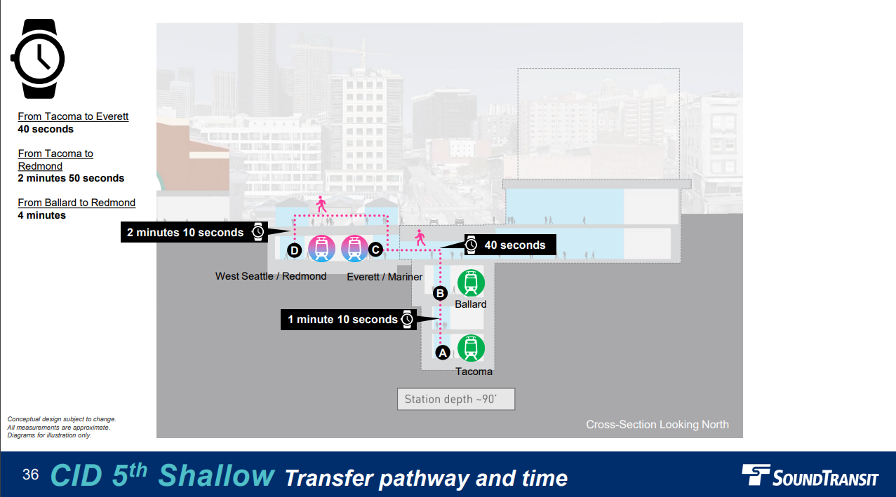
Of the “shallow” options presented, 4th seems to have the most potential. It could be a real transportation hub located between the existing ID station and Sounder/Amrak with direct transfers from buses on 4th Avenue. It also appears to be the hardest to fix for riders without switching to a station design that is as shallow as the existing ID station. Very common transfers from the line that terminates in Tacoma and Ballard are expected to take four minutes. We don’t see obvious ways to speed that up but we’ll leave those solutions to engineers. Sound Transit estimates that 43% of the daily 34,200 riders will arrive via transfers. That means every minute shaved off transfer times will collectively save these 14,700 riders transferring at this station ten days, every day.
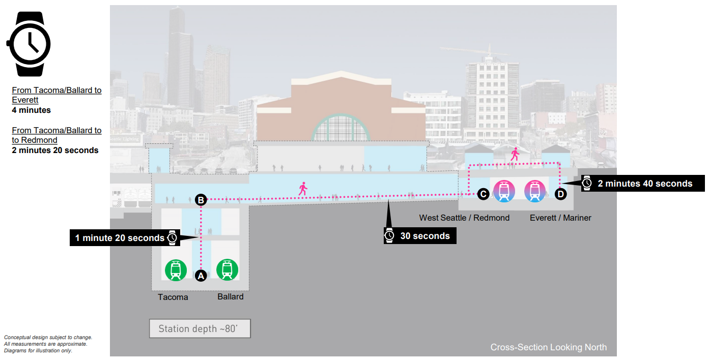
The 5th Avenue “shallow” option trades meaningfully slower transfers to Amtrak, Sounder, and buses on 4th Avenue for what should be much faster transfers to the existing Link tunnel. Yet this option is still marred by a slow transfer from the Ballard line to the Redmond Line of 4 minutes, that transfer includes high volume trip pairs like Bellevue to SLU. The fastest Link-to-Link transfer is a big improvement over the 4th Avenue “shallow” option at 40 seconds, but that one transfer is the only speed improvement this option offers. It does seem like there are more ways to potentially fix the speed of transfers at this location, but as-is it doesn’t perform as well as we’d expect for a transfer station directly adjacent to an existing station.
As with 4th, we have to wonder if a 5th alignment as shallow as the current ID station would look like in terms of trade-offs. In both cases, these options would be almost certainly cheaper, easier, and faster to build. The engineering decision to exclude shallow 4th needs to be reviewed. Using cut and cover to go over an existing tunnel should not be a high risk effort. We’ve requested more details on this decision including the risk register but have not received a response as of this writing.
Of the options we excluded from contention, the deep 4th and 5th stations were obviously bad, but the diagonal shallow 5th had some meaningful upsides in terms of lessening impacts and construction challenges. Unfortunately, forecasted transfer times are as high as five minutes ten seconds so this option should not be considered.
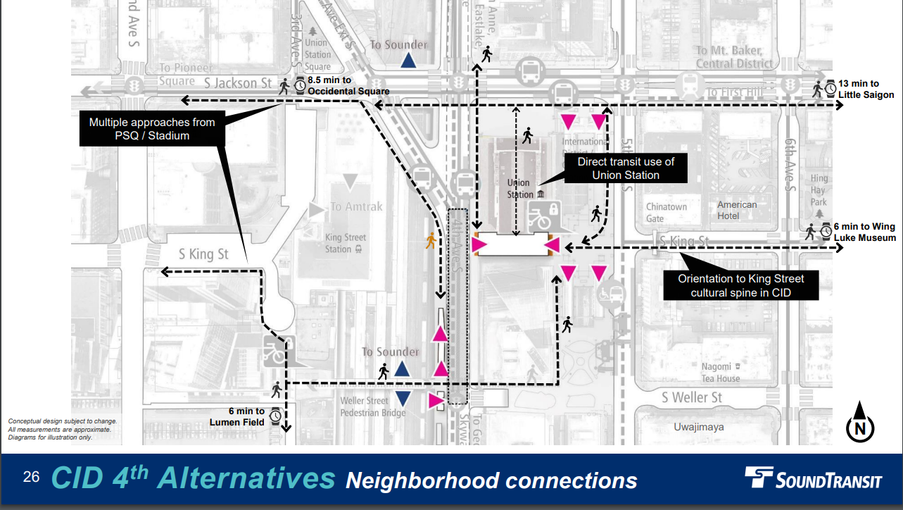
We generally focus on the long-term interests of transit riders above temporary construction impacts, but a station build-out along 5th is under scrutiny for being another in a long line of projects that have major disruptions in the International District. It’s also worth noting that 4th may be a wash with 5th, costs wise, if we consider that the viaduct on 4th needs to be replaced anyways. On the positive side, the station entrances plan for 4th is very good, chock full of redundancy, and seems to consider the best pathways for the most potential use cases. All of that boils down to 4th “shallow” being the best option presented so far, but it needs major improvements in order to work for transit riders.
Westlake Station
We would love to give the same kind of feedback for Westlake but Sound Transit really only offered up one viable alignment (5th Avenue), and one design option for that alignment. This seems really odd for the expected highest ridership station in the system at nearly 74,000 daily riders. Unfortunately, it looks like transfers will be slow at three or four minutes for the 23,000 daily riders who need to transfer here. Details of what makes this station perform so poorly are hard to discern. The station appears to be deeper and more complex than necessary. Without a more detailed explanation of choices made we can only guess. What we can say is that the station as-designed will be a poor experience for riders. This station needs to be improved with an eye on making transfer trips and access to the surface as fast and seamless for riders as possible.
SODO
There is one more transfer station in ST3 that is often overlooked: SODO station. It’s much less complex than the other two mentioned here but is still critically important. Sound Transit expects 79% of the station’s 14,600 riders/day to come from transfers. The worse the ID and Westlake stations are, the more important this station will be for riders traveling to or from points South of SODO on the Central and West Seattle lines. Most of the options offered in the alternatives analysis involve a level station, a new car bridge at South Lander, and involve removing the SODO busway. These are bound to be awkward for the pedestrian experience and we should be slow to let go of important transit infrastructure. If preserved, the SODO busway is expected to carry 30-50 buses per hour post Link construction.
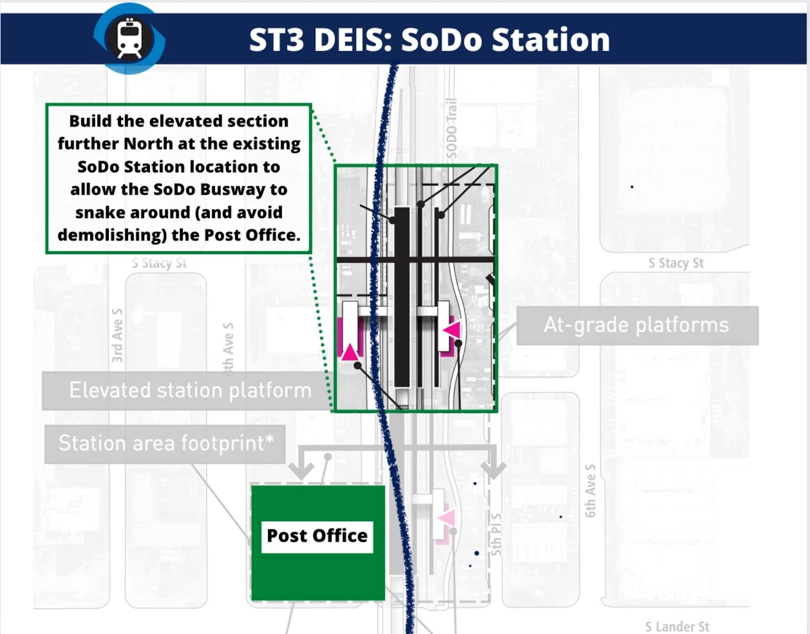
The one alternative to at-grade stations offered is termed “mixed profile elevated’ and appears to have the most promise. This station would be elevated in SODO and would avoid the need for a car-bridge over Lander and the permanent removal of the SODO busway. Transfer speed is slightly better averaged across all potential transfer pairs even though it misses out on the fast (but low volume) cross platform North to Sound transfer. All transfers are at least pretty fast with the slowest options maxing out at 2 minutes. As for SODO station itself, elevated offers what appears to be the most intuitive transfer environment, which can be a big deal when you are unfamiliar with the station and trying to catch a train. This option does retain the gated car and pedestrian crossing at the existing SODO station, but the swing arms have always made this a low conflict crossing for pedestrians and cars.
The biggest knock against the elevated station is price, and a fair portion of that price is the need to knock over a post office building at 4th and Lander. Both the station’s western entrance and the adjusted SODO busway require that demolition. The demolition doesn’t appear to be necessary if the station moves north and the western entrance is replaced with entrances under the elevated station itself, as with most elevated Link Stations. Moving the station north to avoid a conflict with the Post Office is the same strategy employed by the preferred alternative to avoid the expensive demolition, so it’s curious that it wasn’t considered for the elevated option. We would like to see Sound Transit consider this alternative.
The bottom line is that transfer stations need to be built as well as is physically possible. The success or failure of the transit network hangs in the balance of these decisions. For Westlake, we’re disappointed in the lack of options provided by Sound Transit. Westlake is perhaps the most important station in the system and the public has what boils down to a single viable, though somewhat inscrutable, option. Of the options in the International District, a shallow 4th option is the best thing presented by Sound Transit but needs to be much closer to the surface if it is to be successful. We call on Sound Transit to study shallower 4th and 5th options for the ID and if making these stations closer to the surface is deemed impossible, doing everything physically possible to speed up and improve the rider experience.
ST has a very long history of questionable decisions leading to overly complex and expensive results. They bend over backwards to avoid inconveniencing property owners, and we will all pay for it (literally) for decades and ultimately forever (with our time). The East Link process was a joke and I don’t know why I thought this would be any better – perhaps it’s Stockholm Syndrome.
[ot]
It would help if ST provided the estimated t number of transfers by line and direction. A few hundred transfers may be ok as difficult, while over 10,000 should be as quick and high capacity as possible.
True, that would be helpful. Based on the top level numbers we don’t think any of the transfer pairs are expected to be under 1k/day.
Guessing that WS North to points South at SODO will be the lowest expected volume, which really makes that level transfer not all that exciting in the at-grade SODO options.
Running contra-direction to get a north/north transfer there would mean contra in the Rainier Valley, which would be a big safety concern.
In general/As-is – there are some obviously very high volume transfers that will be very slow and therefore bad without more work.
It seems to me that having same direction cross platforms at SODO would help lots. The current plans require at least one or two escalator rides to change between Lines 1 and 3 heading in the same direction.
I also think that there should be two double platforms at SODO rather than one double and two single platforms (three total). The current narrow single platforms aren’t wide enough for transfer crowds and it would reduce the number of needed working elevators and escalators. If the RV tracks are on the outside (a new flyover connecting the westmost track to the southbound Beacon Hill tunnel) and West a Seattle tracks are in the inside, it seems the most logical way to set up tracks for cross platform transfers.
ST is already showing multiple new track structures just south of SODO so that West Seattle trains can directly reach the OMF. Revising the connectivity doesn’t seem like a heavy lift.
A huge advantage of cross platform transfers is also capacity. Not having to walk to an escalator, elevator or stairs and possibly have to wait to use it — instead having 16 doors just 20-25 feet away from another 16 doors on the next train is huge!
Here is a 2017 post discussing the subject:
https://seattletransitblog.wpcomstaging.com/2017/10/05/providing-sodo-cross-platform-transferring/
To be clear, 65 Metro areas worldwide have cross platform transfers including Chicago, New York, Tokyo, London and Singapore. It’s not unusual: https://en.m.wikipedia.org/wiki/Cross-platform_interchange
Yes!! We gotta ensure transfers are EXCELLENT because we’re all going to have to use this system for hundreds of freaking years thereafter… who wants to spend 10 minutes walking past broken escalators and walking thru countless hallways and flights of stairs to reach their train? Not me. Fuck that. Not for what we’re paying.
Let’s get this right. The first time.
Thanks for highlighting this core system negligence!
ST transfer walk time estimates recently developed in their presentations assume using all working escalators. Yet ST has not promised escalator redundancy. In fact there are currently no down escalators to the platform at either CID or Westlake and none I’ve seen added in plans! Those estimates also don’t include the time just waiting to ride an escalator if crowds are queued up waiting to step onto one. What is says will be the time is overly optimistic.
And heaven forbid that an escalator is out of service. They aren’t planning redundancy beyond the required elevators. And unless there are many more elevators also installed, it’s going to be a huge time investment to wait while 2 or 3 or more loads of riders use an elevator in front of you.
Good point. These are time estimates at the best of times. Quite often it will be much worse.
“…, we were disappointed to see that shallow doesn’t actually mean shallow – it just means less deep than the absurdly deep options.“
Thanks for pointing this out! All CID alternatives would be considered “deep” by a rational person. They are shown at least twice as deep as the current platforms!
Who is going to replace Rogoff?
Whoever that is will have an opportunity. They could squander the opportunity, stay the course, and let the inertia of the process that has got us here play out.
They could also bring a fresh point of view and refocus ST’s efforts and studies on ways to achieve a more optimal ridership experience. I’m not going to bet on it though.
“Who is going to replace Rogoff?
“Whoever that is will have an opportunity. They could squander the opportunity, stay the course, and let the inertia of the process that has got us here play out.
“They could also bring a fresh point of view and refocus ST’s efforts and studies on ways to achieve a more optimal ridership experience. I’m not going to bet on it though.”
I thought the same JAS, but thought the new CEO would get honest about project costs for WSBLE and likely future ST revenue (and the fact three subareas don’t have their contribution for DSTT2, an issue I have raised ad nauseum).
When Rogoff suddenly announced the $11.5 billion deficit (about the total estimated cost of WSBLE, although that is probably $6 billion low) I thought ok, Rogoff will do it, with the Board’s consent, and my prediction at the beginning of 2021 Rogoff would be fired by the end of 2021 was wrong. It was hardly a secret in January 2021 that ST 3 had lowballed project cost estimates and inflated ridership and revenue (general taxes and farebox recovery) in 2016 to pass ST 3 in order to complete ST 2 and the spine, with a lot of transit porn for each subarea. Some like ETA pointed this out pre-ST 3 vote, but no one listened to them, at least in Seattle.
Then suddenly, a few months later, in the middle of a pandemic with no new data Rogoff announced the deficit had shrunk to $6 billion, and the Board claimed the “realignment” that extends completion dates concurrently with ST taxes solved the deficit when construction and ROW inflation was the problem that led to the deficit, according to ST. Not only that stations at Graham St. and 130th could be added. For free.
Then Rogoff was very publicly fired for dishonesty, ironically for being honest for perhaps the only time as CEO of ST.
To put icing on the cake, Rogoff then pointed out another obvious fact: ST’s 40% farebox recovery assumption to cover operations was, shall we say, optimistic, before the pandemic, and before the loss of the 100% fare paying peak commuter for a light system that relies on the good faith of riders to pay.
At that point I could have and did predict the alternatives in the DEIS.
The next CEO will be in the same tough spot as the Board and Rogoff are in today: choose a WSBLE alternative that is affordable (which is much less in scope than some of the alternatives on this blog assume, and does not include any tunneling or underground stations, which of course means billions in highly contentious ROW condemnations), or choose one that is acceptable to the stakeholders (downtown Seattle merchants when downtown Seattle is on life support, Ballard and West Seattle where Dow lives) but completely unaffordable.
The Board chose the alternative I would have chosen as a politician: tell the stakeholders they will get whatever they want, if they come up with the money. The reality is just like Bellevue if you tell Ballard or West Seattle they will — as Tom Terrific puts it so elegantly — drink the bitter ale for the good of transit and sacrifice the character of their community to switch from buses to surface rail and stations and years of construction they will demand the surface stations and lines go to the equivalent of 112th, and not vote for Dow for governor.
The DEIS and SB5528 are just ways to buy time so the politicians on the Board can flee the ship and run for some other office before someone breaks the bad news to the stakeholders and very earnest transit nuts. The job of the next CEO — who by definition will not be a transit star because of the awful job he/she will have — is to simply stall: take in the comments on WSBLE which we already know, delay, get excited about the fantastic design (for the stakeholders if not transit riders), and tell everyone ST is just waiting for the SB5528 revenue knowing the territorial disputes between SS and neighborhoods and transit advocates and stakeholders — and Seattle politics in general — means they will never get their shit in order to pass a levy that would need to be at least 10 Move Seattle’s just to fund ST 3, without any new transit porn in the SB5528 levy.
So WSBLE will go to what it always was: a way to get two large neighborhoods to vote for ST 3, and buses like today, probably “truncating” at a light rail station. Then start talking about a new West Seattle Bridge, Magnolia Bridge, and Ballard Bridge (with no loss of car capacity), and those communities will forget about WSBLE.
So to answer your original question who will replace Rogoff, the answer is someone pretty desperate for the money and someone who knows their tenure will be short with a pretty disloyal Board.
My guess is the new CEO will do what any CEO would do, and look around for a subarea with some money to spend, and that is the eastside and Issaquah to S. Kirkland line along with some deferred park and rides, except that subarea is less than agnostic about transit or rail today, and East Link will likely be a dud with 50% of estimated ridership while the 554 will likely be a very popular one seat ride from a park and ride in Issaquah to Bellevue Way. The proof will be when the eastside subarea is not all that keen on accelerating its park and rides from ST 3 that were extended for WSBLE even though the subarea has the money and WSBLE is cancelled so the debt ceiling is not an issue anymore.
Knowing ST it will build anyway, if the subarea has the money, unless some power brokers like Bellevue put a stop to it.
They could also bring a fresh point of view and refocus ST’s efforts and studies on ways to achieve a more optimal ridership experience. I’m not going to bet on it though.
Me neither. I could be wrong, but it seems like the board hires people who are good at getting federal support (Rogoff) or building what we were supposed to build (Joni Earl). I don’t think they’ve ever pursued anyone who would be focused on the rider, the way that a transit agency head is. They have never hired someone like Kevin Desmond, for example.
I suppose you could make the case that Rogoff, given his experience at the federal level, is like that. But I think it is different. Rogoff was largely a bureaucrat, and I don’t mean that in a bad way. If you are a local agency, you need someone to help you navigate the mess to get federal approval (and money) for your project. Rogoff is your guy (or at least one of them). But that is a lot different than what Desmond does, and has done for pretty much all of his career. I would imagine he was involved in various planning decisions — helping to decide where the buses would go. Now he is doing the same thing in Vancouver, but for both the trains and the buses. We could really use someone like that at Sound Transit — especially if they were willing to ruffle some feathers and point out the flaws with the current proposals — I just doubt we will get anyone like that.
Someone Spanish would be ideal, they’d make a lot more money here and presumably not be too worried about their reputation being tarnished since they can go back home.
Kevin Desmond left TransLink and is now a consultant. Yes, TransLink is great. https://www.samschwartz.com/news/2021/5/25/kevin-desmond-named-principal-national-director-transit-and-rail
Thanks eddie — I didn’t realize he left.
I would characterize ST’s designs as engineers who have been told to minimize construction risk & costs over operational reality and functionality for users. With all of the escalator and elevator issues, including outside of the DSTT, the design just comes off as totally out of touch with reality.
Here is a great example (although not directly transferable) of how Stockholm prioritizes transfers on interlined services. ST closed this door by constructing the tail track in the middle of IDS station which is another story, but again demonstrates lack of foresight into functional and accessible station design… https://youtu.be/s07d100dZrM?t=165
Nice piece. Please avoid the word “seamless”; transit has seams; it cannot be seamless. Seams are of distance, time, and information (complex fare and network structures). Seams can be minimized subject to the constraints of budget and right of way. As a rider, I found that TransLink does this well. ST has not done well; in the initial segment, consider Mt. Baker and the airport stations. At the airport, riders oriented to/from southbound bus routes must cross International Boulevard South twice. ST and Seattle have the pattern of devoting the street atop the station boxes to plazas and not buses (e.g., Capitol Hill, Beacon Hill, Mt. Baker, Brooklyn). ST and Mercer Island signed a bi-lateral agreement to insure long transfer walks that had many crossing North Mercer Way. Of course, SDOT has not been great on this margin either; the SLU streetcar line is 1.5 blocks from Westlake station; the CCC streetcar would shift the southbound station a bit further north and put the stop near the Marion Street causeway one block north; the G Line misses Capitol Hill station (the First Hill station was deleted in the aughts) and has one to two block walks at University Street Station.
Transfers are critical at every station. Most riders will access Link via bus. At the CID station there could be Link-Link, Link-Sounder, Link-bus, and Link-streetcar transfers.
addendum: another SDOT example; they are revising the J Line in the U District to use the Roosevelt couplet rather than the Route 70 pathway via NE Campus Parkway and 15th Avenue NE. The bus route will be shorter but the total trips for Eastlake riders will be longer due to wider transfer seams: northbound to Link will have a one-block walk rather than a stop at the station; transfer walks with the SR-520 and ETB services on 15th Avenue NE will require a three-block walk. There will be a longer walk to the UW or the business district. This seems mostly to point the J Line at Roosevelt that is already well-served by Link.
The J Line is an example of the trade-offs inherit with a bus to train connection. A better example is the F Line and its connection to Link, as Brent wrote about here: https://seattletransitblog.wpcomstaging.com/2019/10/05/requiem-for-a-streamline-buses-return-to-the-tibs-loop-today/. The transfer is great, but through-riders are delayed and Metro is spending precious service hours on a questionable loop. In the case of the J-Line, the trade-off is similar — or at least it will be in the future. If the bus turns around north of 65th (e. g. 67th) then the transfer to Link is very good (at Roosevelt). You cover Roosevelt, allowing buses like the 67 to be shifted to The Ave (University Way). You also have very good bus-to-bus transfers (Eastlake to Lake City or Maple Leaf). These are all trade-offs.
In contrast, there is no trade-off with the proposed stations — they are worse in every respect. It will take longer to get to the surface, and it will take longer to transfer to a different train.
RossB: Route 67 could have been on the Ave in March 2016 or October 2021; it need not await the J Line. A longer J Line to Roosevelt does not help the network much. Placing ETB on a couplet requires more poles overhead infrastructure. The notion of the Roosevelt BRT began with the silly McGinn streetcar.
A longer J Line to Roosevelt does not help the network much.
I disagree. If you shift the other buses to the Ave (something I support) than you lose coverage on Roosevelt. It means that trips along the same corridor involving going over to The Ave, and then back. As it is, the trip takes too long (https://goo.gl/maps/2TcFDu4J2eTbvGEw5). That is over 30 minutes, for what amounts to a 15 minute bike ride, uphill (https://goo.gl/maps/vAnH1CcaF8CjFnEs9). You lose the connection to the 62, and as of right now, you lose the connection to Lake City Way (making both of them awkward three-seat rides).
But again, these are trade-offs. Reasonable minds can disagree. But in the case of these stations, there are no trade-offs. These stations are worse for transfers, and worse for riders who walk to them.
A second SoDo station is needed…why? At least with the ID situation, they could argue it would be too congested if it shared 3 lines, at least two of which will be pretty busy. But with SoDo, you’ve only got the West Seattle line and the 1 Line to deal with. And the elevation is not an issue, as an at grade option is on the table. Does it have more to do with the tie-in to the second ID station? You need to build a portal to get underground regardless. The only reason I can think of is no space or vertical clearance for the NB track to go under the existing 1-Line viaduct, on the east side? Based on Google Maps imagery, it would be a tight fit, and might well require a shallow trench. That’s some tricky engineering. But it would surely be less disruptive than an entire station, quite possibly losing the busway in the process.
Of course, this goes to show the importance of planning transfers and how to accommodate system expansions from the outset. This entire discussion would be avoided if SoDo was planned with a West Seattle expansion in mind, and if the original ID were designed as a hub station to handle multiple lines, as it it adjacent to Sounder and Amtrak. Don’t make the same mistakes with the current stations that are being planned, especially Ballard, perhaps also a “Metro 8 subway” connecting at Seattle Center. (And if were ambitious, South Kirkland in case Stride BRT is ever upgraded to rail).
“ Of course, this goes to show the importance of planning transfers and how to accommodate system expansions from the outset.”
There are three more Link stations where multi line transfers will occur.
– Wilburton — center platform and both lines are planned to stop at them. No problem.
– East Main — both lines use the platform but they are side platforms. Either the station should be rebuilt as a center platform for the Eastgate/ Issaquah transfers or the line should branch south if South Bellevue which has a center platform. (Side note that Downtown Bellevue has similar side platforms.)
– Tacoma Dome — Initial designs for this station are underway. While some alternatives put the transfer a level above Line T, others do prioritize this transfer. My preference would be for the single-track T-Link to be in the middle with two center platforms that can load Line T from each side. Still, ST has not made the connection important to design.
Oh and let’s give a dishonorable mention for the Downtown Bellevue Link station connection to Stride, RapidRide and other buses at the BTC. It requires crossing 110th and NE 6th intersection, a place where lots of vehicles also turn.
I remain optimistic the pedestrian experience at 110th and NE 6th will be very much like 108th and NE 6th, which has a frequent, all direction “scramble” crossing for pedestrians.
Excellent article. Just a quick review here: Every proposed station is bad. Same direction transfers and reverse direction transfers vary from bad to terrible. It takes way too long to get to the surface.
We need to study a new approach: interlining, and reusing the existing stations, from Westlake to SoDo. Northbound trains would simply split off after Westlake, with most heading towards the UW, but some heading to Ballard. The line from West Seattle would connect up to the main line just south of SoDo. This would require some work, but likely be significantly cheaper than what has been proposed. It would also be significantly better for riders.
This would provide the exact same throughput through downtown and on each line. It is quite likely that we will never need additional capacity (and thus a second tunnel). Sound Transit has no plans to increase capacity. If, on the off chance we do, it would require additional work on each line (e. g. raising or burying the lines in Rainier Valley) which means that we gain nothing by building this now. It is like building half of a house, and letting it sit for fifty years, on the off chance we’ll build the rest of it someday.
If, on the off chance we do need a second tunnel someday, it should be much better than what has been proposed. I applaud Seattle Subway for trying to get Sound Transit to build a better tunnel (with better stations) but it simply isn’t in their budget, or part of their plan. They rejected a First Hill station a long time ago — it is unrealistic to think that given everything that has happened with the planning (big cost overruns, worse stations in Ballard and West Seattle, long delays) that the planners will somehow build something great as part of this project. In contrast, it is far more likely that if we ever need to build a second tunnel for capacity reasons, it will actually be a worthy project. Transfers will be better, and trips to the surface won’t take so long. Just as importantly, they will follow the traditional mass transit approach of actually increasing coverage in the greater downtown area (e. g. by adding a station at First Hill) instead of the current approach, which is the worst of both worlds. The vast majority of riders in the new tunnel — and this includes existing riders — will wish they were in the old tunnel, and yet very few will bother transferring to get to Midtown. The current plans call for a degradation in service for a significant portion of our ridership (with nothing to show in return). This is unacceptable. But it is inevitable if we follow the current path.
We should pursue interlining, and reusing the existing tunnel stations. If, in the future, we decide we want a second downtown tunnel, let’s hope it is better.
Slightly off-topic but CT is planning to place its Orange Line stop 2 blocks outside the Lynnwood TC / Lynnwood Station. The proposed stop location is 44th Ave & 200th St. The current bus loop is between 46th & 48th Ave. What an awful and backwards plan to transfer between BRT and Link…
Are you sure about that? I see conflicting information, but the more detailed it is, the more it looks like it will serve the transit center. The big map seems crazy, as it looks to detour to Ash Way Park and Ride, but not the station (https://www.communitytransit.org/images/default-source/maps/swiftmaps/swiftorangemap-small_0222.png?sfvrsn=f0547e08_2). But a more detailed map has it serving the transit center: https://www.communitytransit.org/images/default-source/project-images/swift-orange-line-route-stations—draft.png?sfvrsn=5cf32212_0. The EIS (https://www.communitytransit.org/docs/default-source/sepa-documents/orange-line-sepa-checklist_20210603_final-signed.pdf?sfvrsn=fb10e861_0) lists one of the stops as “Station pair at Lynnwood Transit Center”, so unless they consider 44th and 200th to be the transit center, my guess is it will be right next to the train, with the other buses.
Why doesn’t it go on to Edmonds? It’s just ten minutes from the ferry terminal.
Eventually it will, or another Swift Line will, overlapping along 196th, then continuing more due east, follower SR 524 (https://www.communitytransit.org/docs/default-source/projects/long-range-plan/corridor-map—updated-2012.pdf?sfvrsn=4aee7b4_4).
Stopping at Edmonds CC is not a bad choice for now. It is likely a bigger destination, while being shorter (i. e. keeping costs lower).
Again, why is not interlining West Seattle and the Rainier Valley at the existing Lander Station — or better yet, a rebuilt one with a center platform — not being considered. The RV line is limited to frequencies greater than six minutes, and West Seattle will only get every ten minutes because of politics, not ridership.
So why not share the track? It’s NOT hard. Yes, Lander and Holgate would need overpasses, but the northbound West Seattle track can descend to ground level south of Forest by taking the westernmost spur track to the Franz Bakery building and move the lead to line up with the middle track. It would also require that the SoDo trail be ended at Lander instead of Forest, but Forest isn’t much of a destination anyway.
The southbound track would just go straight from the top of the existing rise to structure at the curve into Forest Street. Easy-peasey.
Building a new elevated trackway on the busway is simply foolish over-engineering.
If W Seattle doesn’t provide a one seat ride to DT and UW I think there would be major push back. A better compromise might be interlining with East Link since Bellevue/Microsoft would be a lot more popular than SEA as a destination.
Where did I say West Seatle wouldn’t go to Downtown and UW? C’mon, I’m not THAT bad a writer. What I said was there only needs to be one set of tracks (the existing ones) between SoDo and IDS and how to merge West Seattle into it.
I guess I should have said “interleaving” or “intermixing”. What I mean is that both the West Seattle and the RV trains will go on north to Seattle, just not on separate pairs of tracks. It seems that detailing how the northbound line would run behind the Franz Bakery building would sort of, kinda notify you that we’re talking about going downtown.
But I did probably misuse “interlining”.
Fair nuff, but if W Seattle doesn’t get it’s DSTT2 but does get Link then I think sending them to B’view makes more sense that SEA. There’s a fair amount of W Seattle that works in the Eastside HiTech industry. I think BTC/Spring Dist/MS is a close second to DT/CapHill/UW.
You may be a fine writer… I never scored high on reading comprehension.
It is worth considering what these poor transfers mean. This excellent post alluded to it, in mentioning the transfer from East Link to Ballard Link.
In any metro system, there are a host of trips taken throughout the day — the lifeblood, if you will, of the entire system. There are a range of reasons why someone would ride the trains, but one of the more common is a business meeting in the middle of the day. For example, you want to get from South Lake Union to downtown Bellevue. Enabling trips like this is one of the strongest arguments for building Ballard Link, instead of say, a UW-Ballard subway.
And yet, this is what it would likely entail: You start by crossing Denny, since there are no entrances on the South Lake Union side of things. Then you go down to reach the extremely deep platform, and wait for a train that runs every ten minutes. That is followed by a short ride, and a four minute walk from platform to platform. After waiting for another train running every ten minutes, you are finally on your way to Bellevue. The train is pretty fast, but you’ve actually spent about 45 minutes getting to this meeting. While the trip across the lake is quite pleasant, the trip has been anything but. At every point you are worried about the connection (you don’t want to be late for the meeting). You were able to get a little work done on the trip across the lake, but much of your time was spent hustling from place to place.
This is for a trip that takes around 20 minutes by car (https://goo.gl/maps/1RRiKj9oQgEVfkJY7)! The next time you have a similar meeting, a cab sounds quite attractive. Or maybe you can share a ride with someone (if its a group meeting). This just doesn’t work, even when you are close to both stations.
Of course it would be nice if Link ran the trains more often, but without riders like you using it, they have a tough time justifying that. After all, the core of the system (UW to downtown) would already have good frequency. Just as Northgate to downtown is carrying the system right now, it will dominate non-peak ridership in the future.
If you happen to be on the south side of Denny, you don’t even bother with the station. You just walk to the Westlake Station and start your trip from there (maybe looking over your shoulder to see if a bus or streetcar is headed your way). The Denny Station — arguably the most important station in all of the new track being laid for ST3 — is useless for trips like this. Oh, you can take it the other end of downtown, but why would you? You might as well hop on a bus. There are other trips, of course. If you are headed to Uptown or the Seattle Center, you can check One Bus Away to see if the 8 is coming, or whether you want to try the train. It might be the fastest way to Ballard, if you time the transfer right — but the 40 might end up being faster (and be a one-seat ride). Unless you are headed to Beacon Hill, Rainier Valley or places south, you simply don’t use the flagship station on the flagship line of this multi-billion dollar expansion, even though it is your closest station.
But that’s not all. The other day, someone referenced this post, and it made me laugh (but not in a good way). “Transfers would be world class at both Westlake and IDS” — ha, right. That was bad enough. But the statement that I found really striking was this:
Travel between South Lake Union and Capitol Hill (the “8 subway”) would be effectively solved with a simple underground transfer between a 6-minute line and a combined 3-minute line.
Never mind that Sound Transit is unlikely to run their trains every six minutes in the middle of the day. Or never mind the fact that a “Metro 8 Subway” wouldn’t consist of just one station — as good as it is — in the most densely populated contiguous part of the region (again skipping First Hill, along with much of the C. D.). What is so silly is the idea that someone would actually make this trip by train, on a regular basis. According to Google, a trip from one station to the other takes 7 minutes on the Metro 8 (https://goo.gl/maps/BY7NkrPKQkf4fmxz7). Simply getting to and from the platforms would take longer.
It is easy to draw things on a map. It is even easier to wave your hand, and use vague definitions of an area (South Lake Union, Tacoma) to bolster your case that it will serve those places. But to actually be useful, you need to get the details right, and Sound Transit has completely failed to do so. If this goes forward, it will forever limit the functionality of Link, dragging the entire transit system down as a result.
Seattle Subway, please always referred to the station in the Chinatown International District as such, abbreviated as CID. This is the preferred named agreed upon by all neighborhood organizations.
Why should the rest of the public have to follow what a few neighborhood organizations decide? I grew up calling it Chinatown but the DSTT station name was International District. That was chosen because the non-Chinese supposedly objected to Chinatown for leaving them out, but it turned out they didn’t object after all, it was just a bout of political correctness on the government’s part. But it was too late, I was already used to thinking of it as International District, and still am. Now ST is calling it Chinatown International District. But it seems like nobody asked the public as a whole (I wasn’t asked), some people just quietly renamed it, and now they demand everyone else follow them? It might change again.
CID sounds like Criminal Investigation Division, and is confusingly close to CD (Central District). The biggest confusion I had was when somebody said “ID” and I was wondering “Identity?”, “Industrial District?” until I figured out they meant “International District”.
Is the existing station the “International District Station”, and the proposed new station the “Chinatown International District Station”, or is “Chinatown International District Station” now meant to apply to both stations? Or will there really be just one station – connected?
Sorry, confused.
And how is Chinatown different from the International District? I thought the names were interchangeable.
It is all the same station — they will be connected, one way or another (just like Westlake).
ST’s marketing materials have been calling it “Chinatown International District Station” for a year or two now, particularly in conjunction with ST3, but I don’t know that the signs have changed. Since “Chinatown” and “International District” are interchangeable, it’s the same thing. The second station will be an extension of the International District/Chinatown/whatever station, not a different name.
Fun fact: In Moscow and St Petersburg, most transfer stations have different names for the different platforms. St Petersburg has Gostini Dvor with the green east-west line, and attached Nevsky Prospekt with the blue north-south line. Never mind that both of them are on Nevsky Prospekt street at Gostini Dvor palace/department store. Moscow has a three-platform group where the first two are Taganskaya (purple and ring) and the third is Marksistaya (yellow). And a four-platform group: Arbatskaya (dark blue), Aleksandroviski Sad (light blue), Biblioteka Imena Lenina (brown), and Borovitskaya (gray). To transfer to another line you usually have to go up and down a stair to the other platform or through a passage. But there are a few exceptions: St Pete’s Tekhnologicheski Institut has two platforms with same-platform transfers, so you can go south (blue) and transfer to southwest (red) or vice-versa. Some internal signs call them Teknologicheski Institute I and Tekhnologicheski Institut II, but most signs have one name spanning both platforms. Ploschad’ Aleksandra Nevskova also has two platforms (green and yellow), although I don’t remember whether it has same-platform transfers.
Most cities in my experience have one station name spanning all platforms in a transfer group.
New York City has a number of “stations” with different names for different platforms although riders can walk between them. Unless one station is physically positioned on top of another, I actually think it’s more understandable to a rider.
I would be cool with either adding a direction to a station name (like “east” and “north”) as well as a separate name. (Admittedly, Westlake East does sound like an oxymoron.)
Even in Seattle, we have different names for the many rail stops between Third and Fifth on Jackson.
According to the schedule, the official name is “International District/Chinatown Station”. Calling it just “I. D.” does seem like a slight. The official term is a mouthful (that seems to be the motto of ST — our station names are almost as long as the walk to the platform) which is why people abbreviate. “CID” or “IDC” could be confusing, but it is common for folks here to refer to the station north of SeaTac as “TIBS”, instead of “Tukwila”, even though the former is lot more confusing.
In this case, it probably would have been better to write out the full name and then the full abbreviation instead of leaving out Chinatown (and “C”).
TIB is because “Tukwila International Boulevard” is so long to write or say. I don’t like TIBS because it’s redundant: the “A” in “SEA” doesn’t mean “Airport”. “Tukwila” alone isn’t enough because there’s another Tukwila Station for Sounder. I abbreviate International District station to Intl Dist. ID is ambiguous because SODO is also the Industrial District.
Thanks, Luc! The CID name is a compromise as set forth in City Ordinance 119297. Within the CID are the 3 neighborhoods of Chinatown, Japantown and Little Saigon plus the National Register Chinatown Historic District, which is Chinatown. However, note that at the time (1986), Japantown property owners opted to be included in the Chinatown Historic District designation.
Something to note:
why on earth does 4th Av shallow need an intermediate level between the transfer passage and the platforms? Why does 5th Av shallow need an intermediate level between the two tracks?
And they could probably shave some time off the transfer passageway by constructing escalators pointing east-west through the floor of Union Station; I sure hope they aren’t asking people to use the north-south oriented escalators for that and adding additional distance for fun.
The station depths seem to be what they are so that a boring machine can get under buildings north of Jackson Street. For Fourth Ave, the also have to cross under DSTT.
Maybe not, Al. We would need to consult a 3D map of the underpass of the BNSF tunnel, but if Fourth Really Shallow were at the same elevation as the BNSF freight tracks it seems that if might be possible to go north under Fourth as cut-and-cover, which does rise a bit between Main and Washington and slide across the DSTT. I believe the crossing is made using the Prefontaine Place ROW.
Look at this view from Main northbound with a train in the BSNF tunnel: https://www.google.com/maps/@47.6000558,-122.3291681,3a,75y,90t/data=!3m6!1e1!3m4!1s3-yr_KdnO8Xb2dxY0QlB2A!2e0!7i16384!8i8192
The BNSF tunnel is notched for double stacks so I would expect that the top of the notches is somewhere in the 19.5′ range from top of track. An LRV with the pans at maximum flatness as in bored tunnels is around 16 feet from the railhead.
If the track north of Fourth Really Shallow hugged the retaining wall between the void under the street and the BNSF tracks and rose a bit to consume that three feet of difference the northbound track might JUST BARELY clear the top of the bores. If it’s a few inches too close, the street could be raised a bit.
Immediately north of the overcrossing the c-n-c tunnel would transition to TBM and dive a bit to get under the County buildings and then head diagonally uphill toward Fifth. At least starting somewhat shallower might make possible a bit shallower Midtown station.
But of course we should be agitating for all three lines to be in the tunnel with a Ballard-SLU-Downtown stub or dogbone. That is by far the cheapest quality solution.
I’d hope that ST would choose the dogbone, because Ross’s three way routing offers people from the North or East either the inbound or outbound trip to SLU/Lower Queen Anne in one seat. I doubt they would though. It’s just too elegant.
The BNSF tunnel goes under 4th gradually as it goes north, then at Seneca heads diagonally across the blocks: 3rd & University, 2nd & Union, 1st & Pike.
Any chance of building elevated over the stadium parking lots, use some parking to dive underground, and then go north under 2nd?
Consider the human cost: Chinatown, Japantown, Little Saigon residents and businesses are outraged 5th Avenue Deep and Shallow alternatives are on the table. A 5th Avenue route would devastate the CID communities of color. We want ST3 to be on 4th Avenue to spare 27 business relocations/closures, loss of 230 jobs, construction debris, are and dust pollution to remaining residents, especially over 1200 non English speaking elderly, closed streets/detours of the rest, and disruption to elderly and youth programs (schools, activities for thousands of children, youths) for 8-9 years. Seattle Subway’s conclusion that 4th Shallow is best bears out what CID wants and if that’s too expensive, think of something else, like a monorail down the middle of I-5, as suggested by a state senator.
How would you feel about putting all three lines inside the existing station, Ms Lau? That means no construction for either Fourth or Fifth around CID (except for possible new elevators and escalators).
Many of us feel that more trains can use the existing tunnel than the 20 per direction per hour that ST proposes. We think that the true capacity of the existing tunnel is somewhere between 24-40 trains per hour per direction. Because we are not real engineers we can’t say for sure, but there are many other tracks in subways around the world that are not restricted to the proposed 20 trains an hour in a single direction.
There is more than only a sentiment on here that the need for DSTT2 has not been fully justified. Many of us also think that alternatives to building DSTT2 need through the CID should be considered. One variation would be putting all three lines in the tunnel to Northgate with Ballard to Westlake being a new short line. Another is to have all three lines as far as Westlake in the existing tunnel and find a way to break though the rail tunnel near a Westlake for a Ballard branch line.
“A monorail down the middle of I-5”? Really? Please tell us who this “state senator” is so we can go and laugh at them. [I’m assuming you would prefer to mangle the number of the pronoun rather than having it be “asleep”.]
Consider the human benefits: a 5th Avenue station means shorter walks for most passengers, which would increase business and be easier for workers, as well as people transferring to buses to go further east. 4th Avenue doesn’t have as many destinations or people on the west side, and Amtrak and Sounder come only a few times a day.
Focusing on short-term construction impacts instead of long-term mobility is part of the reason why the Link network and the transit network overall is less useful than it could be or than other (mostly non-US) cities have.
I’ve been attending Sound Transit in-person and virtual meetings since 2018 and indications are they want the new light rail and station on 5th in the National Register Chinatown Historic District, but it will destroy the CID. ST has already taken over the former Metro Tunnel, now the Downtown Transit Tunnel. And now ST plans to take 5th and 6th Avenues. Should that happen, here’s a look back 100 years hence:
2122 In Memoriam: Chinatown, Japantown, Little Saigon
Friends, Residents, Seattleites!
Thank you for coming today to Hing Hay Park to dedicate this unique granite monument in memory of Chinatown, Japantown and Little Saigon, who gave up their communities, their elders and community life so that we today can enjoy the state’s most beautiful transportation tech hub housing office mall plaza!
But first, a little history. One hundred years ago, the three former neighborhoods of Chinatown, Japantown and Little Saigon were parts of a larger district called the Chinatown International District. The CID was the pulsating nexus of the Asian American community and an even bigger draw for visitors from around the region and the world.
But at the time, authorities felt the CID stood in the way of progress, a better future, marked by clean, green transportation for hundreds of thousands, with protesters delaying the building of light rail through the district and delaying creation of this pulchritudinous pedestrian Transit Hub, of which Hing Hay Park is the shiny crown jewel. As Mr. Spock says in Star Trek: The 9th Generation, “The needs of the many outweigh the needs of the few.” Resistance was futile.
We now know overruling those who protested was a mistake. We valued pilings above people, vehicles over vibrant communities, and money over minorities. The 4th Avenue Viaduct Re-build that took place immediately after completion of the 5th Avenue light rail and station wreaked even more havoc on remaining immigrant businesses and residents. Re-build construction and street closures killed off what was left of the CID.
And therefore, the City of Seattle and Sound Transit officially apologize and dedicate this 8’ 8” red granite monument – faced with a bronze plaque outlining the history of Asian American exclusion, expulsion, incarceration, anti-Asian hate crimes and general neglect this day of September 23, 2122 in Hing Hay Park in memory of the former Chinatown, Japantown and Little Saigon.
Obladee Obladah, Mayor of the City of Seattle
Please help us! Here’s a petition to sign and share:
https://chng.it/5qMfLLBD
Thanks for sharing this. The 5th Ave option should be a non-starter. I fear that many folks are missing the “Close Stadium Station for several years” impact noted for 4th “Shallow” in the dEIS. This is lining up to pit CID communities directly against the sports teams/fans, as well as freight and motorist uses of 4th. (Of course, 4th will need to be rebuilt anyways, but apparently nobody told ST.)
Saving 5th is shaping up to be one of the most important fights in ST3, for riders and the community alike. But the opposition from the powerful is likely to be fierce.
I’d have to study the details of the plans to see what impacts would be. There would need to be a noise/vibration impact study. My preference is just stay away from the National Register Seattle Chinatown Historic District. With all these well educated engineers and transportation experts, there must be another way to avoid disruptions to this historic district as well as the Pioneer Square Historic District.
The issue is taking out a community of color and businesses of color in a National Register Historic District: Chinatown. History shows us no good comes from removing businesses of color. They don’t return. There are also thousands of residents to consider, at least 1200 elderly non English speakers. Not a single word in the DEIS about protecting them. In taking the long view, a broader picture is necessary and more than business must be considered. Who benefits and who is harmed? Community life must be preserved. I would agree with you if 8-9 years of construction impacts yielded the existence of the same businesses of color and the same communities of color there now. Look at what happened to D.C. Chinatown when Metro went in. All that’s left is their Chinatown Gate and a Chinese restaurant. The small mom and pops have given way to Nike, Office Depot, Payless, CVS. That’s not what we want for the long term here. The lack of businesses along 4th is exactly why ST3 should be placed there–it doesn’t uproot any vulnerable communities or small mom and pop businesses.
The issue is taking out a community of color and businesses of color in a National Register Historic District: Chinatown. History shows us no good comes from removing businesses of color. They don’t return. In taking the long view, a broader picture is necessary and more than business must be considered. Who benefits and who is harmed? Community life must be preserved. I would agree with you if 8-9 years of construction impacts yielded the existence of the same businesses of color and the same communities of color there now. Look at what happened to D.C. Chinatown when Metro went in. All that’s left is their Chinatown Gate and a Chinese restaurant. The small mom and pops have given way to Nike, Office Depot, Payless, CVS. That’s not what we want for the long term here. The lack of businesses along 4th is exactly why ST3 should be placed there–it doesn’t uproot any vulnerable communities or small mom and pop businesses.
Thanks for your comments, Betty. Seattle Subway doesn’t generally take a position in regards to construction impacts though we can certainly understand why the community would be critical of station plans along 5th Avenue.
As we note ITA, we think the best plan so far is the “shallow” 4th alignment, but that it fails transit riders due to the deep station depth and slow transfers. That said – a similar station along 4th that is actually shallow: At least as shallow as the current ID station and goes over the existing transit tunnel rather than under it would be an excellent option.
We think a real shallow 4th option is a win/win for transit riders and community members that want to preserve businesses along 5th and we hope you’ll join us in pressing Sound Transit to study it further.
It might fit if Fourth could be raised a couple of feet, though the decking would have to be supported very frequently because the cross-supports couldn’t be very thick.
Look at this photo of a train entering the tunnel: https://www.google.com/maps/@47.6000558,-122.3291681,3a,60y,90t/data=!3m6!1e1!3m4!1s3-yr_KdnO8Xb2dxY0QlB2A!2e0!7i16384!8i8192
The tunnel is “notched” for double stacks so the elevation above the railhead of those notches if somewhere on the order of 19 and a half feet. The notches look to be about six to seven feet below the existing road surface.
LRT’s with the pantographs running in “full squish” (I don’t know the technical word) are about thirteen or fourteen feet high. This would be a cut-and-cover tunnel here, not a bored tube, so the base would not extend below the supports. I don’t know what the grade in the existing tunnel from the portals down is, but it’s fairly steep, and it has to underrun the BNSF tunnel in just about a block.
If the new tunnel were right on the other side of that retaining wall above which the camera was placed when the shot was taken, and Fourth was raised a bit to give some extra room. it might work.
And what a relief it would be!
The c-n-c would have to shift to a downward dive immediately beyond the crossing in order to get deep enough to receive TBM’s in a removal vault. I’d say the place for it would be the old white garage just north of Yesler on the east side of Fourth after the jog.
The ask should be three options:
1) Three lines in the existing tunnel with a stub tunnel for SLU-LQA-Interbay-Ballard with a shallow station just north of the existing one. Connect it at Third and Pine with a cross-over within University-Seneca for non-revenue moves. This is by far the least expensive “build” option and solves the real needs of the city.
2) If ST insists that a new tunnel be built, push them hard to do this “Fourth Avenue REALLY Shallow” option with an overcrossing of the existing tunnel.
3). No build.
Oh, I’d of course be fine, even excited, with the dogbone — even a dogbone with Ross’s three cornered operation — but I doubt ST would go for either.
Yeah Tom, I’ve wondered about if Fourth could be a shallower option. Again it would have to cross under or over DSTT near Westlake. Perhaps if the “Midtown” platform connected into Symphony Station at University Street with an underground walkway as the transfer station (New name: Central Link Station?) and the “Westlake” platform was move north a block or two closer to Belltown and the spheres, it could be better for riders as well as walking around Downtown. With the current Midtown so deep, it won’t be used to get around Downtown anyway.
I think we both however agree that the basic DSTT2 assumption needs to be revisited though. I just don’t see why the current DSTT can’t be pushed to 2.5 minute frequencies or better, to enable the capacity.
The promise of six minute trains to West Seattle is operational overkill during peaks. No one seems to discuss that aspect. Further, the need for DSTT2 would completely disappear if West Seattle wasn’t getting its own line. As you point out, Ballard could be a stub or a branch. If the West Seattle riders were in buses, DSTT would certainly not have a capacity issue either. At least half of the total WSBLE cost is thus just to make West Seattle happy and to serve just 26K total activity from West Seattle of whom most will be transferring from buses through a multiple level changes at West Seattle stations anyway. Why are we tearing up CID to make West Seattle happy? The logic has yet to be widely discussed, but at some point, that logic is going to be more apparent to CID stakeholders.
I also want to repeat the need to consider automated trains. They can run more frequently that operator Link trains. Just look at the airport trains!
Which reminds me that platform screen doors are going into more systems. The huge savings from no DSTT2 could be used to add doors in existing DSTT stations, helping both safety and ensuring higher volumes of trains wouldn’t risk interruptions from wayward strollers onto the tracks.
Al, I think the same thing could be true at Westlake, if it crossed under Sixth Avenue. The old Metro DSTT Map shows that the east end of the platforms is just west of Sixth Avenue. The trackway turns up a few feet east of the platform, but if the trench were on the west edge of Sixth I’m pretty confident it could pass over the ramp, essentially at the mezzanine level. I doubt that you can escape a somewhat deep Midtown, simply because of all the foundations and tiebacks, but between Spring and Seneca the buildings in the west half of the block are pretty short, and so, probably not too deep. Then, between Seneca and University the Congregational Church is only three stories, and again, probably without a deep foundation. So the tube could move laterally through that “S”-shaped space and end up under Sixth.
There does have to be some transition between TBM and cut-and-cover for this to work might be here between University and Union: https://www.google.com/maps/@47.6096628,-122.3330879,3a,75y,90t/data=!3m6!1e1!3m4!1scwawl9LGhpa56bp-kCrTQg!2e0!7i16384!8i8192
Tear down that low building and extract the TBM’s there. From there north the tunnel would have to be cut-and-covered, but it’s REALLY not that awful. Then rebuild the retail presence over the vault. There may be an underground garage already under there a part of which could be closed to create the vault and then restored.
The issue is taking out a community of color and businesses of color in a National Register Historic District: Chinatown. History shows us no good comes from removing businesses of color. They don’t return. In taking the long view, a broader picture is necessary and more than business must be considered. Who benefits and who is harmed? Community life must be preserved. I would agree with you if 8-9 years of construction impacts yielded the existence of the same businesses of color and the same communities of color there now. The lack of businesses along 4th is exactly why ST3 should be placed there–it doesn’t uproot any vulnerable communities or small mom and pop businesses.
“The issue is taking out a community of color and businesses of color in a National Register Historic District: Chinatown. History shows us no good comes from removing businesses of color. They don’t return.”
Thank you Betty for bringing this perspective to the conversation. My guess is this blog is mainly white. I think many communities are questioning the benefits of light rail, especially if it is on the surface, condemns a large number of houses or businesses, or disrupts businesses for years.
When faced with this option Bellevue moved East Link from Bellevue Way to 112th because neighborhood character is more important, and harder to create and preserve, than moving transit riders from buses to rail, especially post pandemic.
Anyone who has followed the City of Seattle’s allocation of the homeless during the pandemic when many shelters were closed knows the CID gets a disproportionate number, and it took public outrage for any action at 12th and Jackson, although the situation was ruining businesses that had been there for decades. Few projects have been less racially equitable than ST, and whether a community gets tunnels and underground stations, or like South Seattle surface lines and stations.
There is another significant risk to the CID and that is upzoning and gentrification. Right now building heights under the new zoning are in a no-man’s land between 7 stories which is the maximum height wood framed buildings can go and 21-22 stories at which steel framed buildings become profitable for the developer, especially if underground parking is required (and anyone familiar with parking in the CID knows how detrimental it would be to local businesses to allow hundreds or thousands of new housing units with no onsite parking. For example, we often get take out because parking is so difficult, which means the restaurant loses out on the highly profitable alcohol sales).
My guess is developers will get their wish based on claims of “housing affordability” (and campaign donations) and the maximum building height in the CID will go above 22 stories. At that point developers will demand even greater height if they are going to include underground parking and street retail, just like they did in Bellevue, and of course they plan to include onsite underground parking based on the cost of these new units and the prospective tenants, and the demands of the financiers despite what the city requires, just like Bellevue, because these will be very expensive units for rich people. The claim will be each additional story will include more “affordable housing”, but as in the past that affordable housing will a fee in lieu of, or 80% AMI housing, which is not “affordable housing”, and excludes a huge section of people of color.
At that point the CID will begin to look a lot like downtown Bellevue. Whether that is good or bad depends on your tastes, but based on the location of the CID and just the cost of new development — and profit incentives of developers — the new buildings will house wealthy (mostly white) people, and the street level retail will change dramatically because the retail rents will be unaffordable for the existing businesses, and the character of the neighborhood will change dramatically.
At that point most businesses, like most Black residents who once lived in The Central District, will have to move to somewhere else, probably somewhere in south Seattle (and the tenants in the new buildings in the CID will use door dash to have their Asian food delivered).
“South Seattle” got “surface stations” because it was the first section built. Light Rail was selected as the technology for Link because it could be on the surface, ostensibly saving the cost of elevated and subsurface stations. And it certainly did in the Rainier Valley. The three surface stations in Martin Luther King Jr Boulevard probably cost $15 million apiece. The plan was to continue south from Rainier Beach and then transition to Tukwila International Boulevard (SR 99) using BAR, but Tukwila had just spruced up the road through the village and so didn’t want the train on their street. So, the route was detoured along I-5 and SR518 which had to be elevated because of the grade and curve between the highways. That began the rapid transition to “Link must be grade separated everywhere” that we have now.
So Light Rail is now a cost driver rather than a cost saver and to a significant degree less aesthetic when elevated. Tunnels have to be larger diameter when overhead pantograph collection is used than with third rail and elevated sections have to be really tall and intrusive with the overhead above the decking.
“developers … plan to include onsite underground parking … despite what the city requires, like Bellevue.” Amazon has asked Bellevue to lower the minimum parking requirements because it doesn’t want to build skyscrapers with that much parking. Not sure if you can get a stronger signal that it is the regulation, not the market, requiring parking.
I’m so glad someone finally “gets it.” This is our 3rd and final Chinatown in Seattle. There’s nowhere else for us to go.
Thanks, Daniel for sharing your lived experiences and insights. I just want to point out South Seattle is not a viable option anymore; my neighbors’ charming older homes are slowly being replaced by million dollar “moderns.”
Thank you for your insights and clear explanation.
The lack of businesses along 4th is exactly why ST3 should be placed there–it doesn’t uproot any vulnerable communities or small mom and pop businesses. It would also be a great opportunity for new businesses and new housing to get started there.
The lack of businesses along 4th is exactly why ST3 should be placed there–it It would also be a great opportunity for new businesses and new housing to get started there.
Where could they go on 4th? The eastern half is Union Station and another large building. The western half is King Street Station and the railroad platforms. We’re not going to tear down King Street Station, and it’s unlikely BNSF would allow building above the railroad. I would have supported 4th if it had as many potential destinations and density as 5th or Maynard or further east but it doesn’t.
Can I ask a stupid question?
Why does the 2nd tunnel need to go through the International District at all?
It appears to me that there are only two things that are gained: One is a station at 5th and Madison, and the other is the ability for people from West Seattle to transfer to the line that goes across the lake.
Is that it?
Two other things: 2 Line (East Link) merges there as well as Sounder+Amtrak.
Of course, King St could be relocated. Given the construction difficulty and cost, I wonder if it would be better in the long run to move the connections to Stadium and plan a new TOD district there.
Another concept I wonder about is if there is a way to move the freight tracks into a new bored tunnel (with Diesel locomotives being eliminated in a few decades anyway) and repurposing that tunnel. After all, it’s the deep stations that are a bigger and costlier issue than the tunnel itself. If we are boring from Smith Cove to Holgate anyway, wouldn’t it be much cheaper to run trains without building 6 complicated deep subway stations and putting those stations instead in the BNSF tunnel? Of course, that would leave out South Lake Union but that could be a spur from Smith Cove to Capitol Hill.
It’s the second-largest transfer point after Westlake. It could even be first with Sounder and Amtrak, but more people get on/off at Westlake. Transit agencies are also keen on multimodal transfers, so a transfer to a train, ferry, or airport weights higher than other station locations.
There were some here that were hoping for the second tunnel to be routed under First Hill.
You don’t have to go through the International District, but you do have to go through places where people want to go, or are able to transfer to stuff that does go where they want. Jackson & 4th is a major transit hub. However, if you basically do what the 8 does on the way to Seattle Center and Ballard, you cross almost all of those lines anyway. It means going from Rainier Valley to downtown requires a transfer though. However , if the point of the new tunnel is that the old tunnel is full of trains, then maybe transferring to that line isn’t such a big deal?
It all depends on what you want to accomplish.
I don’t know the answer to your question JAS, but I think the answer is moot.
Those alternatives on this blog that look to use DSTT1 for the WSBLE are realistic efforts to me, depending on what designs N. King Co. can afford for West Seattle and Ballard (and those may be buses truncating at light rail stations that already exist, which is basically what we have today). Condemning or demolishing 600 houses, or entire blocks in downtown Ballard, are not politically possible IMO. Hence the preferred alternatives even though those are clearly not affordable. Floating a DEIS with preferred alternatives that are not remotely affordable even with “third party funding” is a stupid exercise IMO, but I guess ST 3 forced us to go through this process.
ST seems intent on not disclosing just how much money it (N. King Co.) will have, and the true cost of each alternative, (which admittedly is more difficult in the middle or end of a pandemic that does not look good for ST’s assumptions) and most of us are suspicious of ST’s project cost estimates to begin with, let alone a WSBLE that could end up costing $20 billion depending on design and complications for very few riders (which should be reflected in the construction cost contingencies, something ST historically has skimped on).
I can understand N. King Co.’s reluctance at losing $1.1 billion from the four other subareas for DSTT2, but the reality is three subareas don’t have any money to contribute, and don’t have the funds to complete the relatively modest ST projects in their own subareas, which some still have not received. That money never existed, and it was foolish for the Board to claim it did, or would, when it and ST management knew the project cost estimates in every subarea — before a pandemic — were wildly underestimated. Did they expect S. King Co. or Pierce Co. to suddenly become economic powerhouses after N. King Co. had to subsidize so much of the spine because these areas are poor?
Like Ross always says, it is a huge risk to build a fixed rail transit system to places where the people and riders are not, yet, hoping light rail will create them. Unfortunately, King Co. lost almost 21,000 residents last year when this whole charade is based on large population growth estimates in the PSRC’s 2050 Vision Statement that was obsolete when adopted in 2021. https://patch.com/washington/mercerisland/s/i6z1r/king-countys-population-shrank-in-2021-census?utm_term=article-slot-1&utm_source=newsletter-daily&utm_medium=email&utm_campaign=newsletter
For those alternative designs for DSTT2 on this blog I think those are a waste of time, although interesting.
First, the design of a very deep DSTT2 is because that is what is politically feasible whether it is good transit policy or not, and probably necessary considering the foundations in downtown Seattle. Imagine if a shallower tunnel began to undermine the foundations for huge office towers and the litigation over that.
Same with the preferred designs in Ballard and West Seattle. What they want is the convenience (and neighborhood credibility) of light rail with stations like University Street: out of sight, just an escalator descending from the street, which means deep bored tunnels, whereas ST and some transit advocates believe stations need to be monuments to transit, light rail, or ST. Just look at the awful stations on tiny Mercer Island, orange and soaring 35′ into the air for a station 35′ below grade. The gilded age of transit and ST is over, although our tacky stations will live on forever.
Second, because no second “tunnel” through downtown Seattle is affordable, no matter how it is designed, or where it is located to lessen its depth. The DSTT2 alternatives on this blog reflect this catch-22: too expensive to go as deep as ST proposes, and too risky to go shallow through downtown Seattle, even if there was political support for years of construction disruption. No SB5528 levy can make up for this kind of budget shortfall, and it would be foolish for N. King Co. to spend virtually all its transit (and levy) dollars for the next 30 years to complete WSBLE. This time it is not other people’s money.
I would say it is find a way to make DSTT1 handle the volume, but the fact is N. King Co. does not have the funding for the designs Ballard and West Seattle want, which are deep bored tunnels and stations like University St. The addition of the trains from East Link will provide the necessary frequency through downtown Seattle (although ironically few eastsiders will be on them) but the travel from West Seattle to Ballard to a station will be by bus because they won’t sacrifice the character of their neighborhood for more gilded age light rail stations and lines, and they won’t ever sacrifice car capacity over their existential bridges for transit.
So to kind of answer your question JAS the second transit tunnel won’t go anywhere because it won’t get built because it is too expensive to go as deep as necessary, and too difficult politically and engineering wise to go shallow, even if that were affordable, which it is not.
“I can understand N. King Co.’s reluctance at losing $1.1 billion from the four other subareas for DSTT2”
The other subareas would still pay for any upgrades to DSTT1.
“but the reality is three subareas don’t have any money to contribute, and don’t have the funds to complete the relatively modest ST projects in their own subareas”
What do you mean they don’t have money? ST can extend the taxes indefinitely to build what’s in ST3, so it would eventually come. And their budgets were initially designed for Everett Station and Tacoma Dome, and they haven’t had the kind of cost increases WSBLE has had, so they should be fine. Pierce has been saving up a lot of money for Tacoma Dome so it has a large down payment. Snohomish could stop at 128th if it needs to and still have a useful network for Everett and Paine Field.
The biggest issue if DSTT2 isn’t built and DSTT1 isn’t expanded and the Everett and Tacoma Dome extensions are built, will DSTT1 have enough capacity? Although the biggest capacity bottleneck is between Westlake and Capitol Hill, which neither DSTT2 or an expanded DSTT1 address.
“Did they expect S. King Co. or Pierce Co. to suddenly become economic powerhouses after N. King Co. had to subsidize so much of the spine because these areas are poor?”
That’s why SNOHOMISH and PIERCE wanted Everett and Tacoma Dome. North King didn’t shove those down their throats; they were the ones that pulled Link to them. “Powerhouse” is overstating it because I think of a powerhouse as Silicon Valley or Lower Manhattan or Vancouver. “Successful economy with new companies and jobs” is what they’re aiming for. They’re afraid of being economically left out if they’re not on Link, and becoming the next generation of slums. Snohomish also wants more jobs because it has a huge live-work imbalance: 70% of Snohomish residents work in King County. It’s trying to bring jobs so that residents can work in their own county, and it thinks Link will help with that. Again, this is Snohomish and Pierce saying this, not North King or Seattle or King County. The latter three assume the biggest growth will continue to be in Seattle and the Eastside, and will spread out from there to the periphery or maybe not.
“Unfortunately, King Co. lost almost 21,000 residents last year when this whole charade is based on large population growth estimates”
One pandemic year of population loss does not mean the long-term trends have reversed. Even if future annual growth is smaller than expected, it’s still growth. We needed East Link in the 1970s when the population was much lower, so we need it now. And it makes eminent sense to extend Link to Lynnwood to replace hundreds of buses, and to Federal Way for a south-end intercept. Both Snohomish and Pierce have more than 500,000 people, so they need some kind of good transit access to the rest of the region.
“They’re [ S. King Co., Pierce Co. and SnoCo subareas] afraid of being economically left out if they’re not on Link, and becoming the next generation of slums. Snohomish also wants more jobs because it has a huge live-work imbalance: 70% of Snohomish residents work in King County. It’s trying to bring jobs so that residents can work in their own county, and it thinks Link will help with that.”
Do you really think Link will make this kind of economic impact on these subareas? I think that is delusional transit thinking. Transit follows jobs, population and transit ridership, it does not create it. 90% of this region will continue to make trips by car, even after the spine is completed, especially if there is little traffic congestion, or those trips are not peak commuting trips to areas with expensive parking. Bellevue will do fine with East Link running along 112th, and is not at risk of becoming a slum without East Link, and will always provide free parking in off-peak times, even at Lincoln Square while East Link runs empty along 112th.
How does Link help Snohomish Co. keep residents working in Snohomish Co. rather than King Co.? I thought the point of Link was to get folks from Snohomish Co. to Seattle, and to where the jobs are. The jobs aren’t in Seattle because Link runs there. Link runs there because that is where the jobs are/were.
These subareas blew their wad on light rail because that was the only mode really provided to them, and if N. King Co. was going to shoulder the burden to get light rail to their borders then they would spend their ST revenue on light rail, although it is a single line, mostly along I-5, and in many cases even without the transfer will be slower than buses today.
“The biggest issue if DSTT2 isn’t built and DSTT1 isn’t expanded and the Everett and Tacoma Dome extensions are built, will DSTT1 have enough capacity? Although the biggest capacity bottleneck is between Westlake and Capitol Hill, which neither DSTT2 or an expanded DSTT1 address.”
The biggest issue is WSBLE is not affordable for N. King Co. even if the four other subareas can contribute to DSTT2 or to refurbishing DSTT1. Realignments when project completion is concurrently extended with taxes does not create net ST revenue. I doubt all the subareas agree with your view that the Board can extend ST revenues forever if it wishes, especially if it is so four other subareas can subsidize DSTT2 or WSBLE.
The second issue is how many riders from Tacoma or Everett do you think will make an hour long trip on Link to Seattle, especially during non-peak times. I think few. It was a huge mistake to design a $130 billion spine on the assumption light rail riders in the region will take very long and very slow trips on Link. They will take trips from UW to downtown.
Look, I agree the one option is to expand the capacity of DSTT1, if necessary, but I don’t think it will be necessary. Including the trains from East Link, frequency through DSTT1 and up to Northgate should be around 3 minutes, which is pretty good in a post pandemic world.
The only political and financial solution I can find for West Seattle and Ballard is to bus them to a light rail station, unless a direct bus (like the 554) is a much better option. Because the only other “alternative” I think those communities will accept is deep bore tunnels with underground stations with very modest station entrances on the surface, a la University St., which is what Mercer Island should have received. Ballard and West Seattle don’t want the low budget, Walmart tacky station designs MI got. They want light rail, they just don’t want to see it, hear it, or smell it, to quote MI mayor Aubrey Davis when he opposed the expansion of I-90 to 14 lanes, and hence the Lid Park.
I do though think you hit the nail on the head in another post: I believe the Board is hoping for a huge backlash in public comments on the DEIS designs, so it can postpone WSBLE. What it will or can do during a postponement I have no idea, but if you don’t have the money for the project, and the post pandemic assumptions don’t look good, best to do nothing for a bit (which means buses).
“Do you really think Link will make this kind of economic impact on these subareas? I think that is delusional transit thinking.”
It’s not what I think that matters; it’s what the Snohomish County, Pierce County, Everett, Lynnwood, and Tacoma governments think. They’re the reason Link is going up there, and jobs/employers is the reason they’ve given for it. If they change their minds and don’t want Link anymore, it wouldn’t happen.
I agree it’s somewhat delusional. The prestigious areas that attract affluent companies and workers are Seattle and the Eastside. Growth spreads from there. When developers can’t find enough large lots there, employers can’t find enough office space there, workers can’t find enough housing there, especially at 1990 or 2003 prices, then development spreads out. Employers, developers, and residents start looking at neighborhoods they previously wouldn’t. That’s how growth started again in the CD and Rainier Valley, and how it grew in Lynnwood, Woodinville, Issaquah, and Tacoma. South King County was always industrial as south Seattle was, but the 1970s neighborhoods in Renton and Kent were for middle-class white families. That changed in the 1990s as the Eastside became upscale and moved into a different social class, and increasing prices in eastern Seattle displaced lower-income people and minorities into Renton, Tukwila, Kent, and Auburn. But as the population and wealth grows, eventually higher-income people and jobs will spread into south King County as has already started, and eventually development will reach Eastgate too. Unless the economy collapses or the population shrinks, then the fervor for new jobs and higher-income housing will retract back to Seattle and the Eastside where it started.
“How does Link help Snohomish Co. keep residents working in Snohomish Co. rather than King Co.? I thought the point of Link was to get folks from Snohomish Co. to Seattle, and to where the jobs are.”
The Snohomish, Everett, and Lynnwood politicians have said repeatedly over the past ten years that Link is about attracting employers to Snohomish County. That may be different from what they thought in the 1980s and 1990s when Sound Transit was created, or maybe not. They’ve seen the prosperity and tax base in downtown Bellevue and they want that too, or at least as much of it as they can get. Bellevue doesn’t need Link to attract employers because it’s the prestigious area with Bellevue Square, Neiman Marcus, and Microsoft. But Lynnwood, Everett, Issaquah, Tacoma, and Federal Way don’t have that advantage, so they’re looking for something like Link.
Around 2010 a large German company, maybe Siemens, was considering establishing an industrial plant in the Paine Field area. They toured the vicinity and asked the politicians, “What is your high-capacity transit plan? How will workers get to the plant?” The politicians said they didn’t have one; freeways and free parking were their plan. The company was stunned because in Germany that wouldn’t be allowed. Any new industrial center or industrial plant must have a high-capacity transit plan so that workers can get there efficiently; e.g., being on an existing S-Bahn station, creating a new S-Bahn spur or U-Bahn line, etc. So the company left. That spurred Snohomish and Everett to get high-capacity transit to Paine Field so that other companies wouldn’t do the same. When Seattle expressed interest in accelerating ST3 for Ballard-downtown, Snohomish and Pierce jumped on it to get the Spine completed sooner. And soon Snohomish/Everett came up with the Paine Field detour to serve the industrial growth area directly.
I’m skeptical it will help that much. Most employers will be outside walking distance from the station so they’ll need last-mile shuttles. Their buildings will inevitably be spread out excessively, exacerbating the distance. And the further you get from Seattle/Bellevue, the less people want to be there. Link probably can’t overcome all that.
“The jobs aren’t in Seattle because Link runs there. Link runs there because that is where the jobs are/were.”
Both the jobs and Link are there because Seattle is the largest city, downtown Seattle is the largest downtown, and jobs didn’t decentralize from downtown Seattle after WWII to the extent that they did in most other American central cities.
“The only political and financial solution I can find for West Seattle and Ballard is to bus them to a light rail station, unless a direct bus (like the 554) is a much better option.”
Hmm, I hadn’t thought of ST Express from West Seattle and Ballard to downtown as an alternative. Historically Seattle hasn’t had much ST Express, just the 522 to Lake City and the 560 to the West Seattle Junction (now runcated at Westwood Village due to lack of ridership). There was never ST Express from other neighborhoods to downtown because Link was going to take care of that, and Metro’s RapidRide would serve other neighborhoods. There is a long-term concept of ST Express on Aurora, but that has never gotten any further.
But if WSBLE is deleted, then one option might be bus alternatives. ST Express could be one. Stride could be another. Making a larger investment in RapidRide C and D could be another. ST3 already has a small investment in the C and D. It was meant to be an interim boost until Link came, but in the realignment it got pushed to the end. That makes it useless because the C and D may not exist when Link opens so the money would have to go to other routes, and it wouldn’t fulfill its interim role. Still, the existing C & D project is a starting point that could be expanded on.
The difference between Stride and ST Express is that Stride is frequent, has special stations, and street investments. ST Express doesn’t have those. So what it’s called depends on the level of service. The difference between Stride and RapidRide is that Stride is limited-stop and usually on highways, while RapidRide is full-stop and often not on highways, and Metro funds its operations. But it’s theoretically possible ST could fund a RapidRide line for Metro to operate.
I think the route to watch is the 554 from Issaquah to Bellevue Way, and this may be a model for WSBLE. It really makes sense on the eastside: you can run it from park and rides which are a popular first/last mile access on the eastside, and relatively cheap because the driver pays for the car, gas and driver to the park and ride. It will then go to where those folks want to go, Bellevue Way, in part because parking will be expensive there too during peak hours. It is one seat. You can also adjust frequency easily to account for ridership.
The 554, and the likelihood these workers and riders will work part time from home, has many advantages over a rail line from Issaquah to S.
Bellevue, first/last mile being one (unless the light rail station has a massive park and ride next to it), going directly to where the riders want to go — Bellevue Way — being number two, and a one seat ride being number three. I hope the 554 will lead the eastside to rethink spending $4.5 billion on light rail from Issaquah to S. Kirkland via 112th because the 554 is better, and maybe lead ST to rethink WSBLE along the same lines.
“I believe the Board is hoping for a huge backlash in public comments on the DEIS designs, so it can postpone WSBLE.”
Now that is interesting. We have seen in the past ST apparently loading up alternatives with negatives in order to apparently kill them off, so I wouldn’t be surprised if they do that again. But in that case I wish ST would be straightforward and just say what it wants rather than pretending to be for something it doesn’t want. And it seems too much to say ST is engineering a postponement. The ones ST loaded up before were things like the West Seattle BRT studies (some of the public was clamoring for them) and probably some better station options. But in this case, it was ST who came up with these deep, distant stations. Nobody clamored for them or thinks they’re better. It was ST who brought the Ballard 14th alternative forward; only the Port and Fisherman’s Terminal clamored for it as far as I know. (You mentioned the 15th Ave apartments, but I don’t know that they did, or that the broader public did.) ST could have said a year ago, “We can’t build DSTT2 without deep, distant stations”, and started a discussion about whether the WSBLE plan was really feasible without substantial modifications or a rethink. That would have led to the same conclusion, just a year earlier. So I’m not sure that ST is really thinking like that. I tend to take it at its word, that it wants DSTT2 and Everett and Tacoma Dome in its ST-preferred alignments, otherwise it would have told us it doesn’t.
“What it will or can do during a postponement I have no idea, but if you don’t have the money for the project, and the post pandemic assumptions don’t look good, best to do nothing for a bit (which means buses).”
I assume nothing means nothing. Just cancel or postpone WSBLE, and Metro routes will continue as is (subject to the upcoming Lynnwood Link and RapidRide G restructures). Metro will eventually have more money as the driver shortage fades and the economy recovers; then it can restore more of a TBD-2016 level of service, but that won’t affect routing much because the routing is already optimized around Northgate Link and RapidRide C-E. One thing I’d hope for is a revival of a Lake City-Ballard route, but that would require substantial revenue, more than the incremental amount I’m assuming. In other words, it would require upgrading TBD-2020 or deleting those 145th-SLU/First Hill express that RossB hates so much.
“I think the route to watch is the 554 from Issaquah to Bellevue Way, and this may be a model for WSBLE.”
I don’t understand how that has any applicability to Ballard or West Seattle. Where in Seattle is similar to I-90/Bellevue Way? I also think you misunderstand the Bellevue Way situation and the 554 proposal.
Before the 550 there were two Metro routes, 226 and 235. They both went down Bellevue Way to SE 8th Street, The 235 turned off 104th/Beaux Arts, and the 226 turned off 108th/Enatai, so neither one served Bellevue Way south of there. They must have come back up to the P&R at 27th. So neither one served all the apartments on Bellevue Way (the densest part of Bellevue outside Crossroads then), and they were slow because of meandering single-family detours.
When the 550 was created in the 1990s, ST asked the public whether it should go on south Bellevue Way or I-90/405. The majority said Bellevue Way, so that’s what ST did. That made the 550 unusual because most ST Expresses had fewer stops and stayed on freeways. (104th got a coverage route; 108th got nothing.)
When the 550 is deleted for Link, south Bellevue Way will go away unless something backfills it. Metro could backfill it, but ST has funded it for over twenty years now so it’s hard to withdraw from it. Thus the 554 routing, which backfills that segment. That’s similar to ST’s idea of extending the 574 to Westwood Village to backfill the 360 when Stride replaces that. It’s also similar to a lot of Metro backfills over the years.
There was always a debate whether the 554 should terminate at Mercer Island or South Bellevue or bend back to downtown Bellevue. ST simply chose one common option that kills two birds with one stone. It also compensates for deleting Issaquah-Bellevue routes (555/556).
So it’s not as unprecedented as you think, and it doesn’t show some belief that Issaquah-Seattle commutes will drop off precipitously and be replaced by Issaquah-Bellevue commutes. It’s just fulfilling the general Eastside goals that go all the way back to 2006 when ST2 was planned. Both ST and Metro and King County and the cities have long wanted to beef up intra-Eastside circulation. They just haven’t been able to do so within Metro’s limited revenue as long as the Seattle expresses couldn’t be truncated until Link reached Bellevue. Now Link is reaching Bellevue and the long-term plans are being fulfilled.
“N. King Co. had to subsidize so much of the spine because these areas are poor?”
North King didn’t subsidize much. Everybody except maybe you recognized that Intl Dist to Northgate was necessary. Rainier Valley was important because it’s a quarter of the city, a high-ridership area, and for equity reasons. 145th and 185th serve Shoreline and Lake Forest Park, which are part of North King. Snohomish pays for north of 185th, and many North Kingians think an extension to Lynnwood is worthwhile in any case. South King paid for south of Rainier Beach. East King was going to pay for east of Intl Dist, but then it begged North King to pay for Intl Dist to Judkins Park so downtown Bellevue could get a precious tunnel, and North King agreed to. In hindsight, Judkins Park will be more valuable to North King than it had initially assumed anyway.
So the downtown-UDistrict-Northgate axis was a given. Rainier Valley was something North King wanted to get around to eventually anyway. So where are the subsidizes? The fact that Capitol Hill doesn’t have three more stations (Bellevue, 15th, 23rd) to speed trains to Lynnwood? The fact that Rainier Valley came before a 45th line or an Uptown-First Hill line? What do you consider subsidizes from North King to the other subareas?
Perhaps the only major subsidy I can point to is Snohomish benefiting greatly from the Northgate to Westlake tunnel, which was essential for Lynnwood Link, and maybe 185th station which is a North King funded station but a very powerful terminus for Swift, but as Mike points out, North King would build Link all the way to at least 145th even if Snohomish was never involved. The DSTT was built with county-wide funds, so I don’t think East or South King can be accused of being subsidized, and North King certainly benefits from the Rainer-SeaTac and Judkins-Redmond segments.
And there are subsidies in the reverse, with North King never paying into the Sounder or ST Express modes, capital or operations, but Seattle residents benefiting from both when riders ‘reverse commute,’ to say nothing of the value to Seattle employees who live elsewhere but commute into & pay taxes in Seattle. In aggregate, sub-area equity has been very evenhanded, IMO.
No Mike, the “biggest issue if DSTT2 isn’t built” is NOT the capacity of DSTT1. It’s what does the biggest, richest sub-area (North King) get for the taxes it will be paying for an additional twenty-five years? Maybe a tunnel across Merciless Island? Would that make the good Burgers [sic] of that Holy Site happier? They have a lid for their freeway, why not a tunnel for their train as well?
Without some sort of “WSBLE” North King will get Graham Street in ST3. That’s it.
[ah]
Are you worried WSBLE will die and the money will just disappear? Even if WSBLE is completed shelved, North King’s ST3 funds will be spent on *something* with North King. Seattle is ask risk of falling behind in the project queue if TDLE moves into final design and Everett Link [Phase 1] gets through EIS mostly unscathed while WSBLE is rebooted, but there isn’t a risk the money simply disappears.
Seattle also gets Stride 522 and 130th Link station as early wins from ST3, FWIW.
Aside from maaaaaaybe all-day Sounder, there isn’t a regional project out there where the other subarea could credibly ask for North King to pitch in (I’m ignoring assets already classified as regional, such as OMF S & N)
Well, AJ, without “some sort of WSBLE”, what will North King spend money on? NOTHING ELSE comes close to the requirements to “link regional centers”.
This is exactly what Tremens has been angling for the whole time with his attacks on the project. And the moderators can ad hominem me until the cows come home. It’s the truth.
You are right about STRide to Lake Forest Park and 130th. Those are North King. But that plus Graham Street are ridiculously little for 25 years of a penny sales tax.
ST really cannot subsidize bus service entirely within the North King subarea.
It’s plausible to spend North King money on not-Link, though it would be a stretch unless ST gets roped into some bridge replacement. I think something rail will be built to Ballard, a branch or spur and to downtown or UW both TBD.
I had floated the idea of using ST funds to help create a permanent replacement of WS Bridge (not to occur until the back of the plan), under the thought that the 1) bridge is essential for WS transit if no WS Link and 2) it’s an unfunded liability for SDOT
There is a deep bench of bus project ST could invest in – flyover stop for the D in Interbay, a dedicated I5 crossing for the 8, a new bridge in Fremont to convert the current bridge to bus-only, many option for expansion of trolley wires, and so forth – and a few options for non-rail HCT projects, such as upgrading the monorail or building a gondola, or investing in Stride such as extending 522 Stride to Shoreline CC (or branch to Lake City) or launch Stride from West Seattle to Burien/SeaTac/Renton. Again, not saying I’d support it, but it’s plausible. Lose not ye faith.
“Even if WSBLE is completed shelved, North King’s ST3 funds will be spent on *something* with North King.”
ST can’t spend money it on non-voter-approved projects until all the voter-approved projects are fully funded. So if somebody sues ST over misappropriation of funds, it would all depend on how a judge interprets voter intent. I can’t see unrelated Metro routes or a 45th line as a within scope. ST can certainly downscale or defer projects if it doesn’t have enough money to complete them within the timeframe. But can it replace DSTT2 with DSTT1 improvements? ST3 said a second tunnel. There were two projects in the candidate menu for ST3, one for retrofitting DSTT1 and the other DSTT2. ST deselected the former when it selected the latter. So can ST go back to a project it deselected without another vote? IANAL but I have some doubts.
What is in ST3 that ST could leverage? RapidRide C and D improvements. Those were marketed as an interim step until Link was finished, but the realignment moved them at the end to accelerate money to Link. It could restore them to the beginning. It has never been specified exactly what these improvements would be, but I assume transit-priority lanes or maybe acquiring more buses. So if ST cancels WSBLE, it could maybe put more money into the C and D budgets. Maybe it could also upgrade the 40 to RapidRide since it’s also in the Link corridor. In West Seattle, the H (120), 21, and 55 are possibilities. And maybe ST could argue the 56, since Link is also intended to improve 2-seat rides to Alki, so a one-seat ride might be within scope.
I don’t think North King is paying for Stride 3. It was marketed as a benefit to Shoreline and the Northshore cities. It conspicuously doesn’t serve Lake City except in the most peripheral way. The Jackson Park community south of 145th isn’t large enough to be a substantial benefit, and they’ve never clamored for BRT to Bothell. Their focus is downtown and the U-District, as is Bothell’s focus.
AJ, I’m sorry, but ST’s enabling legislation specifies that it will build or purchase rail service OR provide express bus service prior to the completion of a rail line OR provide express bus service between regional centers which have too little demand ever to support a rail link.
Can ST build a bridge over I-5 for a local bus? I seriously doubt it; it might be able to build a bridge of I-5 at 240th to give buses a less circuitous path to the West Kent Station, but not a local city bus.
Don’t be generous and think that the antis will be sated with smashing WSBLE, allowing North King to finagle some bus improvements with its own money. They’ll be in court, probably with Tremens representing pro bono, to kill those bus improvements.
I agree with Mike, though, that improvements to the C and D would probably fly, since somehow ST has been able to finagle the rules to at least plan for rail service to Ballard and West Seattle, even though they aren’t officially regional centers. But even major improvements in that corridor for BRT (short of Ross’s bus tunnel and there we are back to deep-deep-deep) is nowhere near $20 billion over the next three decades.
The suburbanistas are out to rob you.
ST also contributed to RapidRide G and the First Hill Streetcar. The issue is not so much the speed of the bus but that it serve a regionally-significant destination. Ballard’s Market Street and West Seattle’s California Avenue are regional destinations. When I worked in the Ballard Building for a small 15-person company, half my coworkers came from outside Seattle, at least one from Snohomish County. Two other jobs I’ve had in north Seattle also had people coming from all over, including south Everett and Federal Way. People from all over go to the Ballard Locks, evening shows, and for the Ballard experience. Regional transit is for all those kinds of trips. So I can see improving the D or 40 or adding Stride as a possible substitute if Ballard Link is unaffordable.
Sorry, I had an implied ST re-vote in my ‘plausible’ scenario. ST has $227MM (in 2014 dollars, so probably north of $500M in YOE) it can spend on C&D, bus-on-shoulder, and Sammamish. The later 2 have already been deferred, so that’s a chunk of money that can be deployed asap once WSBLE is deferred.
Otherwise, yes if WSBLE is shelved, ST would need to go back to the voters with a fresh list of voter approved projects to ‘repurpose’ the banked North King monies. Maaaybe ST could fund some mitigate for the project being deferred, like it did with the FHSC (which was a proxy for the FH subway station) … it would be ironic if the CCC was funded as mitigation for WBLE deferment.
Looks like Stride 3 is North King, at least partially:
https://st32.blob.core.windows.net/media/Default/InteractiveMap/Templates/July1/BRT_145th_SR522.pdf
And Shoreline & LFP are both in North King, so an extension to Shoreline CC would squarely be within North King’s subarea (but to clear, yes would require a new vote to extend beyond 145th)
“Shoreline & LFP are both in North King”
I keep remembering that in some context and forgetting it in others. I said Shoreline was in North King for 145th and 185th stations, and then when Stride comes around I forget that both sides of 145th are North King.
Mike, there are plans to incorporate Union Station into the 4th Avenue light rail route that have not been fully explored. What I recollect of them is that Union Station would once again be a nexus of transportation. And that would not be as devastating to Chinatown, Japantown, Little Saigon (CJLS). Just as we don’t want 600 homes in Ballard to be demolished (earlier in this discussion), we don’t want the same for the residents and small businesses of the three neighborhoods of CJLS.
Mike, there are plans to incorporate Union Station into the 4th Avenue light rail route that have not been fully explored. What I recollect of them is that Union Station would once again be a nexus of transportation. And that would not be as devastating to Chinatown, Japantown, Little Saigon (CJLS). Just as we don’t want homes in Ballard to be demolished (earlier in this discussion), we don’t want the same for the residents and small businesses of the three neighborhoods of CJLS.
Glad you asked about the name, Al. It’s the continuation of a long history of anti-Chinese fervor. Since the first waves of Chinese recruited to build the railroads, Chinese and other Asians have faced discrimination, even in what we call the places we were forced into: Chinatown, a translation from Cantonese. History: 1882-1943 Chinese Exclusion Act; 1885 Rock Springs, WY Massacre of Chinese Miners leading to late 1885 Chinese expulsion and burning down of Tacoma Chinatown; followed by Seattle Chinese Expulsion of Feb. 7, 1886; next, 1942 incarceration of Japanese, decimating Japantown; then Seattle Mayor Devin’s attempt to preserve Downtown Seattle as a white business area in his 1951 proclamation declaring 4th Ave. to Rainier and Yesler Way to Dearborn the International Center, but only Chinese, Japanese, Filipinos and African Americans are considered “international.” Fast forward to 1975ish: push by some Asians to use International District name in order to represent a larger area than Chinatown to the feds to get large federal block grants for development. Chinatown resists, under the leadership of KC Councilmember Ruby Chow, who brokered a compromise with the then mayor: Chinatown International District. However, new agencies that formed did not honor the compromise and used International District, despite their agencies having to use Seattle CID as part of their name. 1985 saw another push to get rid of Chinatown by nominating it to the National Register as the King Street Historic District. Community outcries ensured and public comment given at Historic Preservation board hearings. Public comments and testimony were organized by Ruby Chow and Ted Pang, president of the Chong Wa Benevolent Association. The State Historic Preservation Board, based on the evidence and testimony of community members, ruled in favor of changing the nomination name to Seattle Chinatown Historic District, which was listed on the National Register of Historic Places in Nov. 1986. The compromise name of Chinatown International District continued and became a Seattle Ordinance (#119297) in 1999. In 2004, KC Councilmember Dwight Pelz sponsored and had passed by the KC Council (against community wishes and against Seattle’s older ordinance ) a resolution that used the backwards name of International District Chinatown (IDC) and since KC runs Metro, the backwards name got stuck on the Metro Bus Tunnel, buses and Metro signage. The ID-C bus tunnel was given to Sound Transit, which has said they would correct it later, in the design phase. Hence the confusion in nomenclature. What Chinatown, Japantown and Little Saigon want is to use our own neighborhood names and get rid of the “international” because we are Americans. The label “international” marks us as forever foreigners and contributes to the anti-Asian hate crimes climate. No other neighborhood in Seattle has to change its name because of diversity of residents. Those marching around to put the international label on us aren’t marching around to change the names of their own neighborhoods so there’s an element of hypocrisy here where there are no demands for the UDistrict to be “International” despite the presence of hundreds of international students or for the Nordic Museum to be the Nordic International Museum in order to accurately reflect the Ballard population. Logically, the Downtown Transit Tunnel should be Chinatown Station or Chinatown, Japantown, Little Saigon Station. Use our neighborhood names, please! We are your fellow Americans.
“In 2004, KC Councilmember Dwight Pelz sponsored and had passed by the KC Council (against community wishes and against Seattle’s older ordinance ) a resolution that used the backwards name of International District Chinatown (IDC) and since KC runs Metro, the backwards name got stuck on the Metro Bus Tunnel, buses and Metro signage.”
The DSTT opened in 1990 and “International District” was the name of the station. The name “International” was chosen to be inclusive of the non-Chinese surrounding neighborhoods. I was never fond of that name because it’s not truly international — all countries or more continents — it’s really Asian, so the name “international” is misleading. The UW dorms are more international (I lived in them). I would have just left it as Chinatown. The name Chinatown in my experience disappeared from formal use and much informal use from around 1990 until the late 2010s. The Link onboard announcements say “International District-Chinatown Station”. Maybe they always did since Link started in 2009. But the station signs are still “International District”, and Metro refers to it that way, and most maps I’ve seen refer to the neighborhood as International District. (And I think of Little Saigon as separate since it’s several blocks away up a hill on the other side of the freeway.) Informal use I usually hear as either “International District” or “Chinatown” but never both.
“No other neighborhood in Seattle has to change its name because of diversity of residents.”
No other neighborhood was named after an ethnic group, and a single one at that.
“the Nordic Museum to be the Nordic International Museum in order to accurately reflect the Ballard population. ”
The Nordic Museum doesn’t represent all of Ballard; it represents the Nordic ethnic heritage. It’s a private building, not a neighborhood name or suyway station.
I can see both the names International District and Chinatown as being possibly problematic, but then I don’t know what else to call it. We could extend “Pioneer Square” to the area, since I’ve always thought the division was artificial. Or “Maynard” might be nice.
Where are “600 homes” to be “demolished” in Ballard? I think you’ve confused
Ballard with West Seattle.
How does digging a trench in Fifth Avenue — which has nine active business entrances, a huge parking lot, and five or six derelict business entrances between Jackson and Seattle Blvd — “devastate Chinatown”? Sure, the businesses fronting on Fifth will be severely affected. That’s what compensation is all about.
But there are four more blocks “behind” Fifth to the edge of the “freeway zone”, all of which have a much higher density of storefronts than does Fifth South. They will have occasional dust and some noise, but beyond Sixth South it will be hardly noticeable. Life will go on in 3/4 of Chinatown.
I am interested what these ephemeral “plans to incorporate Union Station into the 4th Avenue light rail route” might be, and are they really “plans” if they have not “been fully explored”?
Seattle Subway: I have used quotes from your Blog post back in 2018 or 2019 about the 4th Avenue viaduct re-build. The Blog has been very valuable in educating myself on details of what light rail and construction impacts really are. TEA has been advocating Move Forward on 4th, Stay Off Fifth and will continue to do so, pressing both Sound Transit and the City of Seattle on several fronts. This is the ultimate test of the Seattle’s Racial Equity Toolkit, if it’s another list of things to check off for feel good purposes or if it’s a genuine attempt to right wrongs “committed intentionally and unintentionally” and “…listen to and act on what community voices are telling us.”
Is the CID prepared to experience the greatly increased traffic congestion involved when closing 4th for several years? Typically that doesn’t involve compensation to adjacent property owners and it often results in the need to suspend on-street parking and loading zones.
M
Wouldn’t anyone alternative that prevents any street closure for construction in the CID be preferable?
Community architects and engineers have looked at the DEIS Executive Summary and conclude 4th Avenue Shallow has the least adverse impacts on Chinatown, Japantown, Little Saigon. I am reading the DEIS and find it full of deficiencies in that it uses metrics that clearly favor building light rail and a new station on 5th in Chinatown. For example, it compares daily traffic so of course 5th Avenue is more attractive because of less traffic to divert. If it compared number of schools and nursing homes, then 4th is more attractive to build on since it has zero schools and zero nursing homes to adversely impact. Here’s the report from Historic South Downtown Foundation consultants pulling together impacts on the CID’s residents and businesses: https://www.historicsouthdowntown.org/_files/ugd/8f6bad_23154b8f9d0845feae45bd9e55ebf4ea.pdf
The DEIS calls for not only closure of 5th Avenue, but also “full closure of King St and S. Weller Street for several years” Plus a portion of 6th. That’s comparable to closing Market Street or California Avenue or the Ave. for 8 years or so.
That graphic for 4th shallow shows a long, but fairly straight walk from the 4th Ave side to the existing tracks.
If they build it this way I’m going to want to see a moving sidewalk, like I’ve seen frequently in airports.
On Saturday I tried the Link to 255 transfer at UW/Husky Station on the way home from the airport with rolling luggage. It’s not a good experience.
One of the two platform elevators was out of service. That meant a fairly long wait. That elevator was still out of service on Monday.
On reaching the surface I found that there is no good way to get to the 255 stop. There is no crosswalk across Montlake Blvd as far as I can tell, neither on the shortest path between the Link exits and the 255 stop, nor at the corner of NE Pacific Place. If you take the pedestrian bridge, then you have to carry rolling luggage down a narrow stairway to reach the bus stop. I can’t tell if you stay on the bridge whether you can eventually reach the stop on a ramp, but if you can it is a long way out of your way.
It was touted that in return for giving up direct service to downtown Seattle on the 255, that there would be 15 minute service 7 days/week. Well that promise is not being kept as the weekend service is 20 minute service, not 15 minute service.
Why don’t routes 542 and 271 serve the same stop as route 255? When headed to many Eastside destinations you may be able to take any of the three buses (for example when you could choose where to connect or where to have someone pick you up or transfer to an Uber for the last bit) This will be even more so when the 271 is changed to remain on SR-520 to Bellevue Way.
There is no schedule coordination between the bus and Link.
If we were to compare bus/rail/streetcar transfers in Toronto or some cities in Europe, they do make it much easier for passengers than our examples so far here in Seattle. Certainly neither Mt. Baker nor UW are done in a friendly way. And to think that the UW entrance is in the middle of a parking lot that could so easily be a transit center if we had the political will to prioritize that experience.
“There is no crosswalk across Montlake Blvd as far as I can tell, neither on the shortest path between the Link exits and the 255 stop, nor at the corner of NE Pacific Place”
There are two crosswalks, one at the south point of the triangle, and the other at the Pacific Place intersection. It’s not the shortest distance, but the shortest distance is in the middle of a block. The 255 stops are the easiest to get to of any of the bus transfers: 45, 48, 65, 75, 271, and 372 riders wish their stops were as close as the 255 stops.
“It was touted that in return for giving up direct service to downtown Seattle on the 255, that there would be 15 minute service 7 days/week. Well that promise is not being kept as the weekend service is 20 minute service, not 15 minute service.”
Covid hit right after the restructure, and ridership and sales-tax revenue plummeted. Currently there’s a shortage of bus drivers, both at Metro and nationwide. When these return to normal, full frequency will return. Partial frequency has been restored, with 15-minute peaks and 20-minute noontime every day including Sundays.
“Why don’t routes 542 and 271 serve the same stop as route 255?”
I wish the same about the 271. On Sundays the 550 is half-hourly, so if I miss it I think about taking the 271 or 255 instead (the 255 to South Kirkland P&R), but they both stop at different stops so I’d have to guess which one will come first. Fortunately i’ve been able to run to the 550 and catch it, so I haven’t had to take these options.
A lot of good points here. The transfers for the most common, which is probably from one Link line to another, need to be as short and convenient as possible. And yes, ST has a poor history, I believe in large part due to non-riders or riders who rarely ride transit, and when they do, a single line, populating the Board and the staff presenting to them. I don’t expect that to ever change, as ST has shown an unwillingness to flex and adapt as the environment changes. The environment has particularly changed in the last few years with the pandemic resulting in more remote working and more flexible working permanently, climate change bringing more electric and self-driving vehicles, Paine Field emerging as a commercial airport, and more. By sticking to the “same old, same old,” ST and other transit agencies are pursuing a fool’s errand, but they continue to do so because they are spending other people’s money and aren’t innovative thinkers, which the worst of the lot of agencies have long ago acted more like private and not public companies.
The board should have looked at transfers when it first started thinking about a second tunnel. Train-to-train transfers are practically the #1 issue. Yet the Board didn’t make Intl Dist center-platform for Eastside-airport transfers, didn’t make the second Westlake and Intl Dist platforms close to the existing ones, and didn’t include a stub interface at U-District station for a 45th line that’s in ST’s long-range plan. Seattle Subway and others have also asked for stubs to potential future Aurora and Georgetown lines, and crossovers so that trains could use either tunnel if one is closed or if we later want to restructure the lines. ST neglected all of that.
“Sound Transit, At Least It’s Better Than Nothing”. Although with the way WSBLE is turning out, maybe in this case it’s worse than nothing.