A series of public meetings focused on limited segments of the WSBLE DEIS is underway. Those who are unable to attend can comment by email, voicemail or snail mail using this page. You can even schedule a 20-minute virtual meeting with the project team to ask questions about the DEIS in the meantime.
As a supplement to the previous Ballard-focused post, I wanted to include some brief details about the South Interbay (Smith Cove) segment shown below.
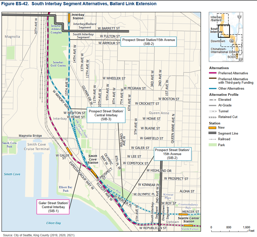
You can find details about each of the proposed alternatives on one page here. Key impacts such as estimated costs, ridership, displacements and disruption from construction are summarized here.
Below are some site context photos scraped from Google Street View. Note that these are the approximate suggested station locations, not the suggested station entrance locations.
SIB-1 Galer Street – Looking northwest towards Magnolia from Elliot Ave W
SIB-2, SIB-3 Prospect Street – Looking northwest towards Magnolia from Elliot Ave W
A few notes about this segment:
– These alternatives will likely see less discussion than the Ballard alternatives given their substantially lower ridership estimates.
– As with the Ballard/Interbay segment, the track alignments here are somewhat interchangeable; station placement will be the key decision point.
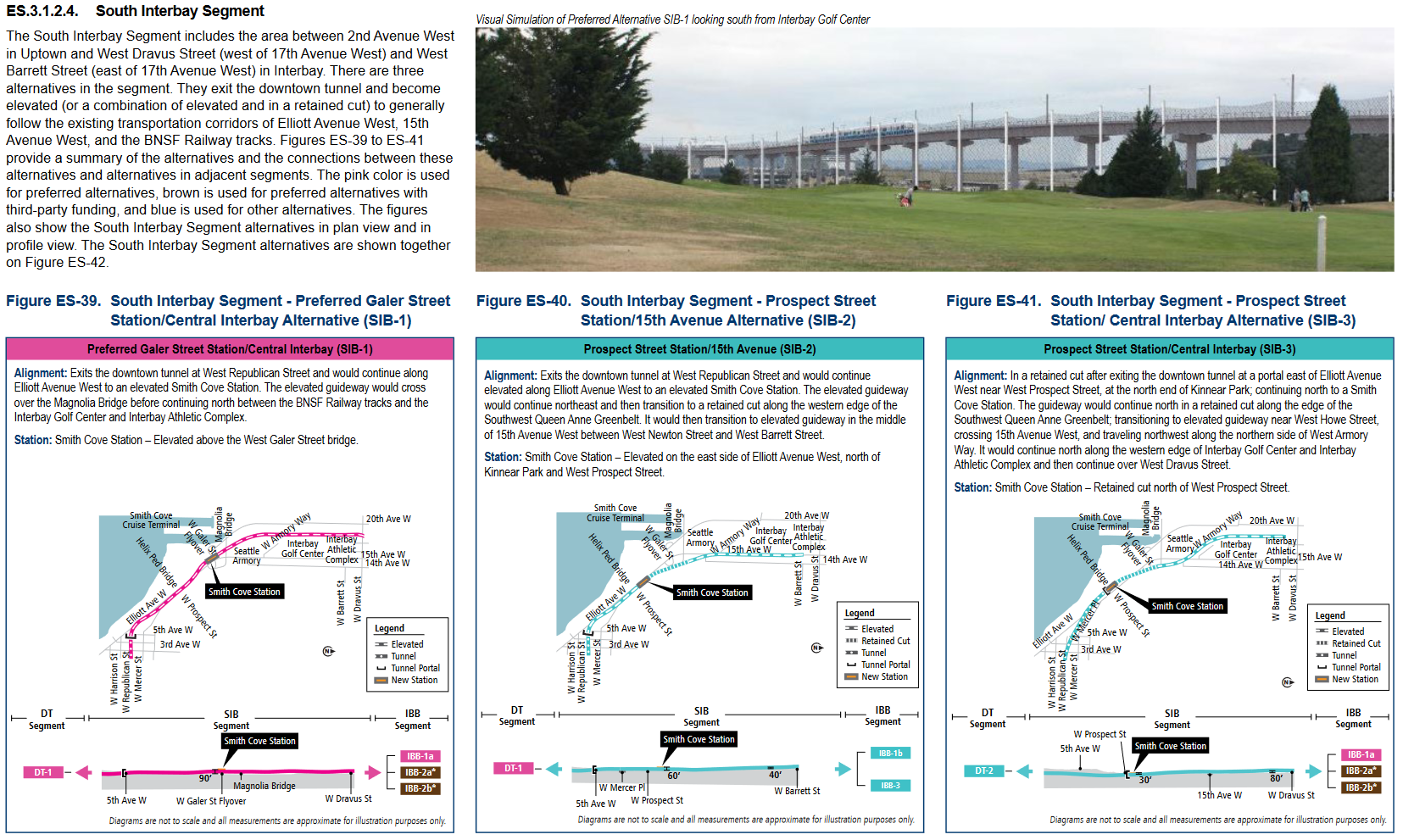
– The proposed station designs for each alternative vary substantially. SIB-2 and SIB-3 contrast modestly elevated and retained-cut stations respectively, while the preferred alternative (SIB-1) would resemble the SeaTac station with a platform about 65ft above street grade. You can delve further into the station design details at this community advisory meeting timestamp.
– The DEIS provides ridership and impact estimates for an M.O.S. scenario. These altered values estimate how the Smith Cove station would function if it was amended to serve as a temporary line terminus, presumably due to funding constraints.
Be sure to speak up in the comments about your preferred alternative.
Other useful links:
DEIS Executive Summary
DEIS Section 2 – Alternatives Considered
Public Comment Page
WSBLE: Interbay and Ballard Community Advisory Group Meetings (#1, 2, 3)
How on earth did they manage to make this section cost almost a billion a mile, it should be the easiest and cheapest part of the whole project, besides maybe SODO. Going around the Galer St flyover seems to be the obviously correct option but somehow it’s even more expensive and not preferred? I swear this whole mess just doesn’t make any sense.
I agree that the station concepts are very expensive given expected ridership at each. Many of those riders are also not walking, so that how it interfaces with buses is going to be more important.
I’m not clear why Interbay even needs a mezzanine. It seems like an unnecessary extra level change adding cost, vertical conveyance maintenance and extra walking effort and time inside the station. While it’s a seemingly minor point, it could be indicating a mindset that pervades the DEIS to overbuild stations.
A note about “preferred” in the report: it was selected before cost, design details and impacts were known a few years ago. It’s not a new recommendation and if there are better reasons for an alternative (more benefit, lower cost or lower impact) the Board can easily revise the designation they made without detailed info.
I guess because it’s so high? ST just seems to love mezzanines, the 14th St station having one is the most baffling of all.
It could be merely that when cost-cutting is needed, there is an easy way to save some money.
Never mind that the designers of these stations work for international engineering firms who stand to gain millions for the next 20 years on this project — and possibly more if it becomes a design-build project. Plus, they need to evaluate a worst-case scenario for environmental impact analysis. Their job right now is to overbuild!!!
I believe the high cost is because the alignment is either elevated or in private ROW. The retained cut option (presumably the cheapest to construction) is all in private ROW and therefore includes the high cost of Seattle real estate. At best, the alignment options are ‘adjacent’ to public ROW, rarely actually within the ROWs.
Haven’t ST’s historical elevated expansions been closer to $200MM a mile? Either they’re spending $800MM/mile on property acquisition or… I don’t even know what. Either way it’s nuts. ST has proved they can build transit for an acceptable price despite the weird political constraints, but at this point it should be cheaper to just tunnel the whole thing. What happened?
James: well done.
Both options make pedestrian access difficult and ask some conceptual bus routes to deviate. At Smith Cove, the station hugs elevated roadways; at Interbay, the station hugs the BNSFRR yard. Both options ask intending riders to cross arterials to/from bus routes. Perhaps those issues could be improved by sliding the stations along the alignment.
Is there a way for West Queen Anne to reach the Smith Cove station? Like a pedestrian path from the SW QA Greenbelt or Kinnear Park? That would at least allow the denser housing near 10th Ave W to get to the station? Or is Smith Cove mainly a transfer center for Magnolia?
There’s been some speculation of a stairs climb adjacent to the station, but I haven’t seen anything in the official plans. If they are able to create one, it would really improve access to 10th, as you say.
For buses, I would imagine the Interbay station is the more relevant intercept for W & N QA.
West QA buses currently just go down to Seattle Center via 10th W and Olympic and wouldn’t intercept in Interbay. But if there is a walking path directly to Smith Cove station from West QA, that would allow for greater housing density along 10th Ave W and the land to the west of it.
Would tunneling and serving upper QA really be substantially more expensive? Focus on access, as costs seem to have no relationship to anything obvious.
heh… the objection to Queen Anne was that the station would be super deep….
doh!!
I’d still like to see a dual Link/Sounder Station somewhere in the Interbay segment. It might not have a lot of ridership at first, but it would create another transit network connection that could be valuable in the future.
I’m also wondering if the Skylink folks have looked at connecting Link in Interbay to Queen Anne via gondola. I’ve no real knowledge of this, but from Queen Anne to Ballard seems like a longish trip and being able to hop on a gondola (maybe from the north part of Queen Anne), and in a few minutes be able to get onto a Link train going north to Ballard seems like it might be useful – even assuming that there are buses at the south end of Queen Anne that hook up with Link at the Seattle Center.
An alternative fantasy is a 4-gondola hub at Interbay going to Ballard, West Woidland, Fremont and Queen Anne. That would lower Link construction costs and make amazing connectivity. Heck, gondolas to Magnolia and the cruise ship terminal could even be added.
Frankly, the Dravus station couldn’t be in a worse spot. I hate how it misses West Queen Anne apartments and condos — only to be placed in a land of rail yards and soft souls that limit building. We whine about 14th in Ballard not bring optimal — but this is not just sub-optimal but it’s probably the worst possible location possible.