

This week is all RapidRide as we review the Candidate Corridors analyzed in Metro’s recently published RapidRide Prioritization Plan.
King County Metro Corridor 1064B, a potential RapidRide conversion of Route 36 — traveling between Othello, Beacon Hill, Jackson Street, and Downtown Seattle — was recently set as a Tier 1 priority corridor for future RapidRide expansion. Metro also considered a northward route replacing much of Route 49, from Capitol Hill to the U-District, but ultimate prioritized focusing on Route 36.
The proposed conversion would add speed and reliability connecting South Seattle to the rest of the city. Metro’s primary recommendation for RapidRide-ization of the route is the construction of a moderate amount of BAT (business access and transit) lanes.
Alignments
As part of Metro’s review of the candidate corridor, Metro studied two alignment alternatives: Corridor 1064A, which would replace Route 36 and continue north to replace Route 49, and Corridor 1064B, which would primarily replace Route 36.

Two alignment alternatives are discussed in Appendix D: Corridor Reports. Alignment 1, green 1064A, combines Route 36 with the northern portion of Route 49 along Broadway through First Hill, bypassing downtown and Jackson Street. Alignment 2, yellow 1064B, retains the 36’s routing on Jackson Street and downtown.
Unique among the RapidRide candidate corridors, King County Metro moved forward with fully analyzing both alignment alternatives (all other routes just had one representative alignment), but eventually chose the existing alignment Route 36, corridor 1064B.
Metro studied some route changes for both alignments. An alternative on 12th Avenue (shown in gray) was rejected due the high cost of adding trolley wires on 12th. An extension on Pike/Pine downtown (also in gray) was rejected as duplicating RapidRide J.
One minor change made it through initial screening: a reroute in North Beacon Hill moving service off 12th Ave S and onto 14th Ave S to eliminate the current one-way couplet.
Corridor 1064A Delays and Improvements

The bus delays for the Broadway alternative are predominantly concentrated along U District Station, 10th Avenue, Capitol Hill Station, and Beacon Hill Station.
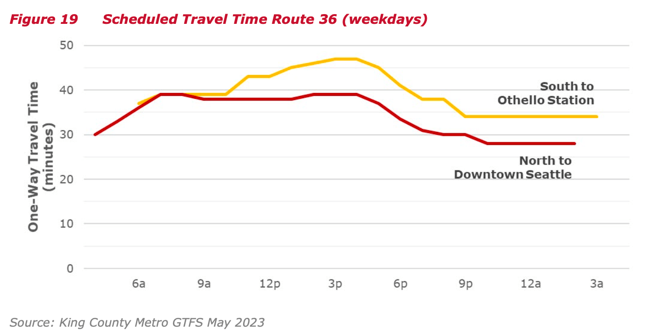
Usually the existing Route 36 bus ride from end to end takes 30 minutes without traffic and 40 minutes in typical traffic, while during the PM peak traffic can take up to 47 minutes southbound. The existing Route 49 suffers from higher variability as fast as 20 minutes without traffic and up to 48 minutes during peak traffic.

Addressing the delays, the proposed transit investments are divided into four sections:
- Bus/BAT lanes along NE Campus Pkwy and Eastlake Ave E both directions;
- Bus/BAT lanes along 10th Ave E both directions or if not feasible implement queue jumps;
- Bus/BAT lanes along Boren Avenue northbound and 12th Ave northbound plus southbound queue jump at 12th Ave S & S King St;
- Bus/BAT lanes along Beacon Ave south of Jefferson Park in both directions.
The proposed improvements will improve peak travel times by 14% in the northbound direction and by 19% in the southbound direction. This notably misses out on improvements in Capitol Hill probably from complications with the streetcar. Same for the missing Beacon Hill Station bus lanes originally suggested 2 years ago facing issues with fitting the BAT lanes alongside the proposed bike lanes for the Beacon Ave S & 15th Ave S Safety Project.
The 10th Avenue E BAT lanes will be complicated by the proposed 10th Avenue E bike lanes in the Seattle Transportation Plan. There is currently around 40 feet width, so fitting general lanes, BAT lane and bike lanes simultaneously will not be possible even with the removal of parking.
Beacon Avenue south of Jefferson Park is wider and the bike lanes are in the existing grass median allowing adding the BAT lanes without any issues.
Corridor 1064A Station Stops
The RapidRide standard targets one-third of one-half mile station spacing. Currently the stations on Route 36 are on average one-fifth mile apart (1,100 feet). Around 70% of the existing bus stops are less a quarter mile apart.
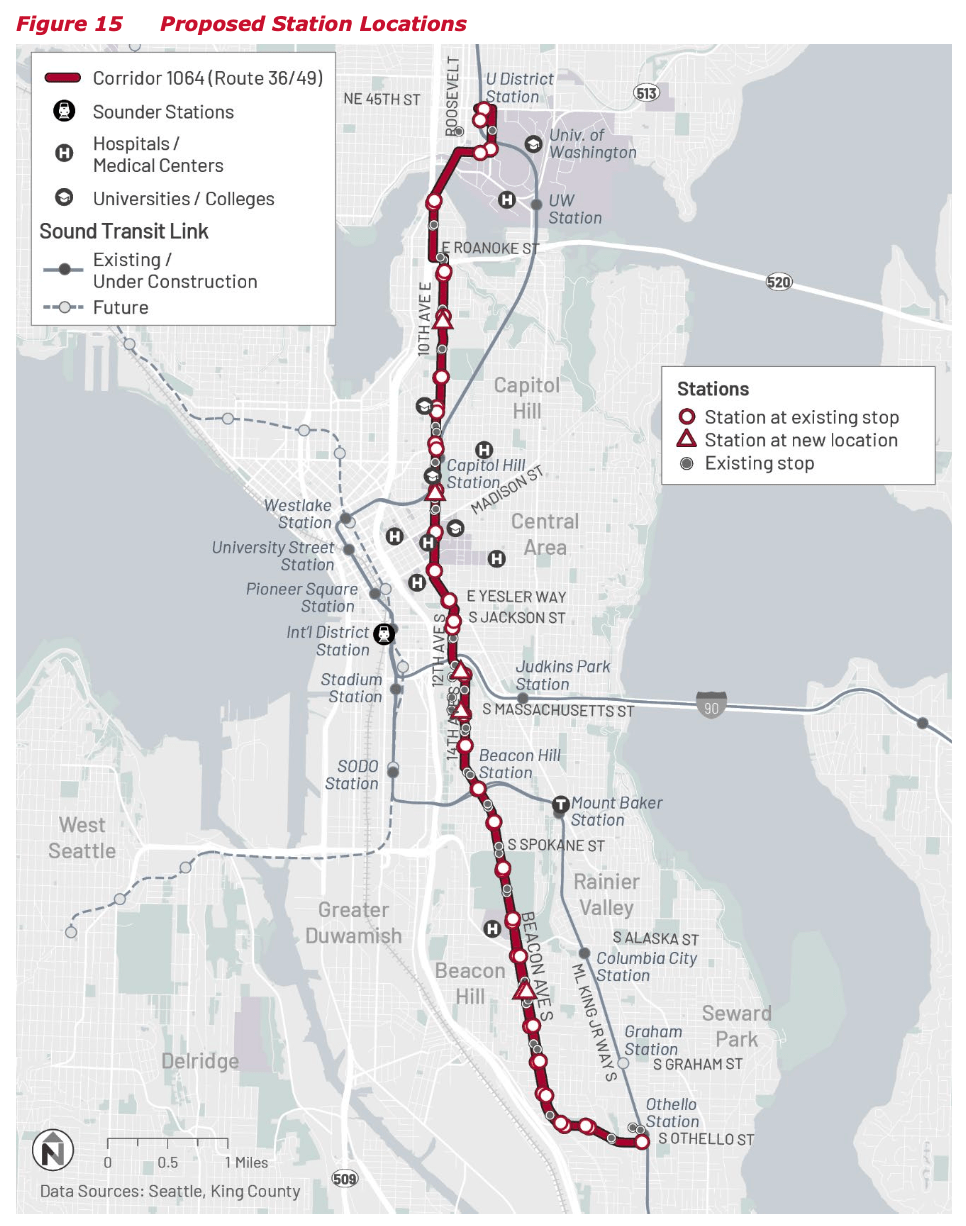
Corridor 1064B Improvements and Station Stops

Corridor 1064B would implement all of the same improvements as Corridor 1064A south of South Jackson St, so the same details above apply. In downtown Seattle it would use the existing 3rd Avenue transitway and no further improvements are proposed there.

The proposed station locations on the shared segment are the same. The downtown Seattle segment will use the existing RapidRide stations while the Jackson Street segment will share stops and improvements chosen by RapidRide R.
One other relevant near-term project is $2 million 12th and Jackson Transit Hub project, which will:
Construct new transit passenger and pedestrian facilities at all four bus stops at the intersection. Work includes new unique and high visibility bus shelters with weather protected seating, sidewalk widening and curb bulb-outs, traveler information and wayfinding signs including real-time passenger information, pedestrian scale lighting, pedestrian guardrails, ADA curb ramps, and enhanced electrical infrastructure.
This project just went to bid, with construction starting next Summer, finishing in 2026.
Outcomes

The BAT lanes and station spacing would provide an estimated 14~19% speed benefit. Through if implemented now would provide a minor speed benefit closer to 5%. Given future land use changes, the current 10,244 weekday ridership would jump to 13,700 daily boardings. The estimated weekday productivity of the line would also jump to 62 riders per revenue hour compared to the current 37 riders per revenue hour.
Prioritization
As the only route analyzed along two corridors, King County Metro had to choose one of 1064A or 1064B to move forward with in the Appendix E: Evaluation Results.

The 1064B alignment of the original Route 36 was chosen with the higher equity scores regardless of the weighting.

Most of the metrics measured for both alignments were granted around the same points with the exception that the new corridor would have less households and jobs within a walkable range. Though given such a metric any bus route that doesn’t run through downtown would always be compared unfavorably. For either alignment they were both the highest rated and Corridor 1064B was slated for Tier 1 prioritization alongside Corridor 1049 (Route 150). This tier is for projects Metro intends to construct with existing funds before 2039 after the current slate of RapidRide projects are completed.
Costs
Alignment 1064A (36 + 49) would cost $61,440,000 with 61% for stations and stops; 32% for transit speed and reliability; 3% for layover and terminus facilities; and 4% for trolley infrastructure. Alignment 1064B (36) would cost $34,290,000 with 68% for stations and stops; 24% for transit speed and reliability; 5%for layover and terminus facilities; and 3% for trolley infrastructure. Excluding the stations and stops, Corridor 1064B‘s speed/reliability improvements and layover facilities could perhaps be built for only about $10 million.
Conclusion
Converting Route 36 to RapidRide will significantly improve travel times and reliability for Beacon Hill residents. By prioritizing the existing route, adding bus/BAT lanes, and enhancing stations, King County Metro will create a faster, more efficient connection to downtown. While initial speed gains may be modest, the project will support future growth and continue to serve the community. The proposal rerouting to First Hill and Capitol Hill still holds much promise and can be revisited later in the future.
What is the plan for fleet replacement? Are there fully-electric RapidRide buses on the way? Or trolleys? Or will some of the existing trolleys be painted red?
Or, are they going to replace the trolleys with hybrids, going backward on CO2 emissions?
At least with current ridership and 10-minute headway, the 40-foot trolleys are handling the ridership. So maybe make the ROW improvements, and wait a few years on the other stuff.
The plan is full electrification, with current trolley routes becoming trolley RapidRides, and non-trolley routes becoming battery buses with charging infrastructure at layover stations.
I’ve said this before, but one hidden cost of electrification (at least with the options currently available today) is that it tends to lock current routes in stone by making future service restructures too expensive to pencil out.
For example, if a route has trolley wire, it can’t be modified or extended without building new trolley wire. If a route is run with battery buses, but needs charging infrastructure at the layover point, then the route can never be extended without either paying the enormous expense to relocate the charging equipment (and its high-powered utility connection), or creating an awkward situation for passengers where buses stop for layover in the middle of the route, rather than at the end.
Of course, that’s not to say that new infrastructure can’t be built, but all too often the bus network remains stuck in the past because the ridership on existing trolley routes isn’t there to justify the huge capital investment in new trolley wire that would be required to modernize the network. For example, one big reason why Upper Queen Anne has no direct service to Fremont, and is unlikely to ever get such service in the foreseeable future, is that the cost of extending the #13’s trolley wire over the Fremont bridge is too high.
In the case of the 36, one could imagine all sorts of routing tweaks that could be done at either the north end of the south end. But, the cost of the trolley wire modifications/additions would be high, so unless the ridership justification for the change is very compelling, it doesn’t pass cost/benefit muster, and the route’s existing service pattern just persists. Even without trolley wire, modifying the 36 to not go downtown would be difficult to get through, as the beneficiaries of the change would be people who don’t currently ride the bus system, while existing riders would storm the county council meetings and complain about the loss of the one-seat ride to downtown. With the trolley wire, the change goes from difficult to pull off to outright impossible. I’m quite surprised Metro even bothered to create a map for the option.
“If a route is run with battery buses, but needs charging infrastructure at the layover point, then the route can never be extended…” I don’t think that is true because the bus doesn’t need to layover between each run. BEBs may need to come out of service to recharge, but that will be on layovers where the bus is out of service, such as during a driver change, and even today some routes need to travel a bit to return to a layover location for driver changes. There may be a time penalty vs a diesel bus (which can typically run 3 full shifts before heading back to base for overnight refueling) if BEBs need midday charging, but not so impactful that routes cannot be extended. Charging infrastructure will be focused on major transit centers where routes are most likely to converge & terminate and therefore layover. A layover spot that is the tail for a single route is unlikely to ever have charging infrastructure.
BEB range is mostly an issue with freeway running routes, which is why ST is still buying only diesel buses for the double decks, and those busses are likely the last to electrify.
Also, in motion charging will allow for flexible tails. We already have this for trolley buses, which can run ~ 15 minutes off wire, allow for buses to detour for various reasons (construction, paving project, major events). As that technology improvers, the need for overhead wires can be focused on certain high volume corridors, where wires can charge multiple routes, with no need to wire individual route tails. The best example of this will be 3rd Avenue – eventually some buses will be able to operate mostly off wire, charging when they pass through downtown to extend range in addition to getting a full charge when out of service overnight.
Here’s a good example of a proposal to use in motion charging to charge on the trunk while operating off wire on branches: https://pedestrianobservations.com/2022/04/08/providence-should-use-in-motion-charging-for-buses/
That’s an interesting article. If it really is that easy to have a trolley/battery hybrid route, that would address the inflexibility argument. Maybe the #13 can finally be extended over the Fremont bridge, at least enough to connect to routes like the 5, 44, or E-line.
Of course, this solution only doesn’t work nearly as well in east king or south king, without an established trolley network, but even just applying it within Seattle can make a lot of sense.
There is one catch, though. An awful lot of the time, I observe Metro running trolley routes with diesel buses, which suggests that the trolley wire is having maintenance issues and is not very reliable. If it’s just a few routes that are trolley routes this isn’t too big of a deal, but if the number of trolley routes increase to point where Metro is forced to buy extra *diesel* buses, just to provide backup service during wire outages, I can see that getting expensive.
” just applying it within Seattle ” – right, I think KCM needs to have two totally different approaches for Seattle, focused on trolley buses operating out of central base, and for the rest of the county, which should probably focus on BEBs operating out of south & east base.
I believe the trolley wire gets turned off regularly for maintenance. I don’t have any expertise here, but it feels like KCM should be able to reduce these maintenance windows as the overall fleet electrifies. For example, the overnight service may need to be all BEBs to allow for trolley wire work to be done during the overnight shift.
“Metro running trolley routes with diesel buses, which suggests that the trolley wire is having maintenance issues and is not very reliable.”
They de-energize the wire when there’s construction somewhere along the route. This often happens on weekends, so weekend runs get dieselized for months.
Just to clarify the rapidride prioritization plan does not call for electrification of all routes. this route 36 will continue to be electrified and talks about minor wire extensions for other routes but for the existing not trolley bus routes the funding analyzed continues them as diesel hybrids.
There is a separate electrification plan which talks about it, however recently auditors have found it to be unreasonable and that the technology is not ready yet.
https://kingcounty.gov/en/dept/metro/programs-and-projects/zero-emissions
Anyways if you’d like to discuss it more probably for a different thread/article where we can deep dive into the report.
Thanks! And thank you for writing for STB!
In a way, all the sub-fleets will be battery buses; the ETB and hybrids also have batteries. The size of battery varies between the sub-fleets.
I hope Metro and SDOT expand the ETB network. They seem to be going backward now (e.g., G-line, routes 10, 11, 12, 49). Even before Covid, routes 9 and 29 were hybrid going under the overhead. Could the next G Line sub-fleet be ETB with batteries? It was only the last procurement that the vendor did not have an artic ETB that powered two axles and could climb the Madison grades. (Metro and SF Muni do not use the artic ETB on steep grades; here they are QA, Madison, James).
The Swiss, Austrians, and Germans have much better ETB networks and practices. Could we have in-motion charging of ETB with batteries for the gaps in the overhead?
The power, range, and decay of the batteries are issues. This may be worldwide.
What’s wrong with hybrid buses? Metro seems to be in a dubious rush to make all the non-trolley buses battery when hybrid-electric vehicles use much less fossil fuels than pure diesel vehicles. And the greatest reduction happens when ten people switch from SOVs to a bus — any bus, including diesel. Which they would do if the buses ran more frequently. So is the perfect being the enemy of the good?
One annoying bottleneck is the poorly-placed bus stop across from Beacon Hill Station. Only one bus at a time can stop there, even though it serves three routes. The next bus then has to wait behind the new stop light, often through an extra cycle.
I would suggest moving the stop south to allow two consecutive 60-footers (though using 60-footers there is rare).
I hope the new stop lights are paid for out of some non-transit fund since their sole purpose is the speed up car traffic in front of the station. If they were there to benefit riders crossing the street, they would have been on-demand lit crosswalks, such as the ones a couple blocks down at the newish, but single-story, library.
Originally the plan was for 2 bat lanes and two general lanes in the middle as there’s around 40/42 feet by removing the center median. With the proposed bike lanes the might still be able to add a BAT lane in one direction but not both.
That center median is practically brand new, and due to its poor engineering, likely to become the cause of a speeding-car/bus collision.
There are other potential places for bike lanes, such as around the other side of Red Apple.
But I’ve thought it would be even better to have that minor detour be for cars, and eliminate car traffic in the block between the station and Red Apple. If SDOT’s intention was to do something about the high probability a pedestrian would eventually get hit crossing the street there (and it is high due to the sheer number of people who cross there), then removing car traffic from that block could do wonders.
I’m agnostic about how the block should be striped if the car traffic is removed, but it is, essentially, an all-day, seven-days-a-week school zone, without the benefit of signage to tell cars to slow down. Maybe Washington State needs “transit zones”.
One other option I’ve pondered is to remove the extra turn from route 60, and let it have its own stop pairing (that would include 107’s first southbound stop) over at 15th and Lander. But people would still have to cross Beacon Ave S.
From my observations, all SDOT succeeded in doing with the new median and light was increase car speed on that block (including impatient drivers zooming around stopped southbound buses, barely squeezing around the median, and making riders occasionally miss their bus connection because some of them actually obey the don’t-walk sign.
Add bus lanes to 10th Ave E? This is not a congested street by any means. Removing parking unnecessarily affects a neighborhood that is, imo, not transit-dependant. The actual section of Cap Hill that will benefit from street reconfiguration is Broadway, from Pike to Roy.
Metro has decided to skip the 36+49 route and prioritized the 36-only route.
For 10th Ave E, SDOT has plans for either bike lanes or bus lanes.
> Removing parking unnecessarily affects a neighborhood that is, imo, not transit-dependant
That kinda means no bus/bat lanes anywhere though if we follow that logic.
You have a good point, Wesley. Lemme clarify: exchanging parking for bus lanes in an area with hardly any congestion and the bus operates just fine unfairly affects businesses and residents in that neighborhood. Bus lanes are meant to give buses a leg-up over traffic congestion. If there’s no congestion, then why add the lanes?
Bus lanes and parking removal make way more sense on Broadway than a nearly-all residential neighborhood.
“Bus lanes are meant to give buses a leg-up over traffic congestion. If there’s no congestion, then why add the lanes?”
Because they may be congestion they’re not paying attention to. Because congestion can arise faster than the bureaucracy can mitigate it. Because it sends a statement that the city takes transit seriously and the neighborhood has good transit. That encourages people who want good transit to consider that a viable place to live, reveals that demand for transit and alternatives to driving is higher than people assume, and makes people more willing to vote for other transit projects.
According to the map (https://i0.wp.com/seattletransitblog.com/wp-content/uploads/2024/07/image-25.png?ssl=1) there is congestion along the corridor, which makes sense. It isn’t there there is high density there, but it is a corridor — a way for people to get from one place to another. If 10th was a really fast corridor (with no congestion) then drivers would go that way and pretty soon you would have congestion.
It may not be as congested as other places, but taking parking is one of the cheapest, easiest things you can do to make the buses faster. The number of parking spots is minimal (people can just park on the side streets).
There’s two different issues here.
One, frequent bus routes should generally have lane priority for the entire route. That’s how to get a highly-effective transit network that attracts the most people out of their cars.
Two, some of Seattle’s streets are too narrow for this. Market Street on the western slope of Phinney Ridge is only three lanes. If you take two for buses, that leaves only one for cars in one direction. The hillside prevents having a parallel street the other direction. The area is so choc-full of moderate-density housing that I don’t see widening the road. So the only choice is for buses and cars to share a lane, at least downhill.
But, Seattle hasn’t been aggressive enough with transit-priority lanes in cases where it can, where there’s already four lanes or six lanes, so you could take two for transit/BAT/FAB and leave 2-4 lanes for cars.
Hi everyone, hope ya’ll like the article. Here’s some questions I’d like to hear your thoughts on:
1) what do you guys think about the route 36+49 versus chosen route 36 only, with the new route to capitol hill versus maintaining the route to downtown?
2) any thoughts about the new transit hub rebuild on 12th and jackson?
1) I really like the idea of combining the 36 and 49 (as I explained in a comment below).
2) This is good, but Jackson really should have transit right-of-way. It is tricky because of the streetcar, but there were plans before that sounded very impressive (https://seattletransitblog.com/2015/12/21/rapidride-the-corridors/). (See the section for Corridor 3). Anything to make the buses (and streetcar) faster through there would be worth it.
1) Redirecting route 36 out of the Central Business District is politically DOA. Chinatown/Japantown will not have it. SAGE moved its office to Chinatown. They will not have it.
There ought to be a route that runs the entire length of Broadway. Let’s call it FHSC, just to put a number on it. I bet it would be a very popular route, if it comes every five minutes. Ten minutes would work until The Great Conjunction. At 15 minutes, I would wager that ridership would start dropping dramatically.
2) The only purpose I can see for a rebuild at 12th and Jackson is an excuse to temporarily shut down the open-air market. But I don’t think it will even do that. I have no problem walking through that loose business zone, but I get it that others do, and they’ll probably end up having to do more of that during the latest rotation of sidewalk furniture.
I used to go there a lot for the vegan banh mi one of the cafes sells, and the vegan Buddhist restaurant on the north side of Jackson. I stopped going there because of relaxed food handling hygiene standards, not at all because of who was hanging out on the sidewalks along the way.
Brent seems correct on the fate of routes 49-36 of Metro Connects; the SDOT and Metro planners (note that there are probably several groups within each agency; this RR phasing report is by longer range planners) had not discussed the concept with the community well; now they have; there is a strong connection for the direct connection between Beacon Hill and the CID; (probably much stronger than the “save the 42” movement that led to the SE Seattle change in fall 2016 and the Route 106 extension).
I suggest a revised network that does not follow the Kubly SDOT RR lines. That got the whole program into trouble. SDOT and Metro need to rethink the network with Link. Link is key; it can carry the radial load. How can we improve service to good transit markets by shifting the bus emphasis?
Restore Route 43; this would isolate the Montlake congestion on one route.
Consolidate routes 8 and 48 between Uptown and Mt. Baker via Capitol Hill and Judkins Link stations. This is a good candidate to become ETB.
Consolidate routes 49 and 9 between U District and Rainier Beach Link stations via Capitol Hill, Judkins, and Mt. Baker stations.
Achieve 10-minute headway on routes 36, 49-9, and 8-48.
Forego coverage of MLK between East Arthur Place and South Plum Street. SDOT could use it for bike emphasis.
Shift routes 14 and 36 to 1st Avenue from 3rd Avenue (along with several hybrid routes serving SODO). Extend Route 14 to Summit; extend Route 36 to routes 10 and 12.
Truncate the FHSC at 5th Avenue South to allow ETB to access 1st Avenue and improve its own frequency and reliability; a win-win.
Shift the extended Route 106 to 23rd Avenue South and Yesler Way from Rainier Avenue South and South Jackson Street. This would greatly improve service on Yesler Way with its high equity scores; it would serve the 23rd Avenue side of Judkins; it would still directly connect ACRS and the CID.
Extend all-door boarding and alighting, POP, and inspection to all ETB routes.
The McGinn SDOT slowed Broadway down with the FHSC and PBL.
In the mid-term, could a variant of the G Line extend to Madison Park? There are red buses available when it does not provide six-minute headway.
Extend the 60 to the U-District and eliminate the 9th Avenue detour, and voilà, a Broadway north-south route between 12th & Jackson and the U-District. Then the 49’s fate can be considered separately.
“Extend Route 14 to Summit”
Where have I heard that before? Oh yes, it did that when the 14 at Thomas was my route. Eastbound was notoriously late do to congestion on the rest of the 14. I’d wait for it and it was 10-15 minutes late, and I’d see one or two 43’s passing in the meantime or right before the 14’s scheduled time. Many people including myself took the 43 rather than gambling whether the 14 would show up by the next 43.
I’ve argued for quite some time now that the 49 should be sent to Beacon Hill. There are a number of ways of doing it, but combining the 36 and 49 (1064A) and making it RapidRide has a lot of advantages:
1) It is a long, straight route — the type we know perform well.
2) This bus would be as frequent as the streetcar and share many of the same stops. Thus much of Broadway would have six minute frequency — a major improvement.
3) By being RapidRide the payment type is the same as the streetcar. Thus riders can board at any door no matter which vehicle shows up first.
4) The 60 can be sent downtown. This actually saves time for the 60 (which is good, since it is longer than the 36). The 60 can take advantage of the right-of-way improvements along the shared corridor.
5) It saves quite a few service hours by being more efficient. You avoid the time consuming back and forth of the 60 on First Hill. You eliminate the redundant trip downtown for the 49*.
6) The network is much simpler and more frequent, especially on Broadway.
Overall it is just much better.
* Here is a map of the bus routes after RapidRide G. The 49 passes by Capitol Hill Station, then the 11, then mixes with the 10 and 12 to go downtown. But it doesn’t really form a spine along Pike/Pine. The 10 and 12 are slated for a combined 10 minutes, and the 49 every twenty (so they can’t be timed). Thus sending the 49 downtown doesn’t really help the network. If we wanted to improve the Pike/Pine corridor then we could restructure the buses for 7.5 frequency all the way to 14th. Either way, if we sent the 49 to Beacon Hill riders would have great alternatives for going downtown (link or a frequent combination of buses) and it would greatly improve the network.
+1, sad the 36-49 idea got canned.
I am a Capitol Hill resident, and from what I’ve seen the 49’s ridership has been a lot lower since the Northgate Link extension (so low that it’s being disconnected from the 7 evening trips in September). Sending it to Beacon Hill is a great idea for creating a new connection to places like First Hill and reviving ridership.
from what I’ve seen the 49’s ridership has been a lot lower since the Northgate Link extension
That is not too surprising. Part of the reason is the poor frequency. But partly it is due to the fact that a lot of trips are better with Link. The various combinations of U-District, Capitol and downtown are now replaced by Link. Link is not extensive. Riders close to Campus Parkway would much prefer a direct ride to Capitol Hill or even downtown. But the infrequency causes many riders to abandon it.
Merging it with the 36 solves both of these problems. You give people in the area a major destination: First Hill. This is an area that Link doesn’t cover. Thus someone from the U-District (especially down by Campus Parkway) would definitely take the 49 to First Hill. Even if they end up taking Link for the first leg, they would greatly benefit — as would a lot of other riders — by increasing the frequency on Broadway from every twelve minutes to every six minutes (by combining the bus and streetcar).
The increase in frequency of the 49 (from twenty to twelve minutes) comes from the savings that come from a restructure. The 49 essentially ends at Broadway & Republican (where it then becomes the 60). But the 60 is much straighter, which in turns saves money as well. What might be a stretch now (the 49 running every twelve minutes) becomes affordable. This in turn allows it to compete with Link. For example notice this trip is actually faster via the 49, but at this time you are actually better off walking back and forth to Link: https://maps.app.goo.gl/KJicruywUzr4vmfV7. It takes too long to wait for the bus. If the bus runs every twelve minutes then this happens rarely (if ever) and a lot more riders benefit.
Sending it to Beacon Hill is a great idea for creating a new connection to places like First Hill and reviving ridership.
Exactly.
This is part of a broader problem where crosstown service gets neglected in order to maximize the number of people that have a one-seat ride to the traditional downtown area. The fact that the corridor to downtown already has a 100-year history behind it, plus trolley wire which would be very expensive to move, further bakes in the downtown-centric network. And, of course, the fact that what transit resources are available for crosstown service on Broadway are being spent on a streetcar that doesn’t go much beyond walking distance is also not helping things.
Ideally, SE Seattle would have both a route to Capitol Hill via Boren/Broadway (without the time-sucking detour to the front door of the hospital that the #60 does), and another route to South Lake Union via Boren/Denny. Unfortunately, it doesn’t look like either of these routes are going to happen for the foreseeable future.
While I’m glad that Metro at least took the time to bother putting the 36/49 combo route on a map, it was pretty clear from the beginning that the path of least resistance and fewest people complaining at service planning meetings is to just keep the path of every route unchanged, and tell people who want to make crosstown trips to just suck it up and either ride a bus through downtown, transfer to Link, or go get a car.
Except in this case the cost to move the wire would be minimal, as much of the wire would be reused. Combining the 39 and 46 means you only have to run wire on Broadway between Pine and Jackson. I think a lot of that section has wire anyway (because of the 43). Just by looking at Google streetview, it looks like there is wire the entire way For example here is wire on Boren, crossing Yesler and heading south towards Mount Rainier (https://maps.app.goo.gl/pDMzmPXopPd4bZVB7). Thus it is is quite likely you wouldn’t have to add an inch of new wire.
RossB,
the combination of routes 49 and 36 needs a new switch in the middle of 12th Avenue South and South Jackson Street; it would become a grand junction. Route 9 was ETB before 2005.
https://kingcounty.gov/en/dept/metro/routes-and-service/schedules-and-maps/009#route-map
the combination of routes 49 and 9 would not need any new overhead.
Converting Route 60 to a radial route from a crosstown would go a bit backward. Today, it connects with Capitol Hill via First Hill. It other activity centers have their own radial routes; see the H Line and routes 124, 131, 132, 36, 3, 4, 14, 27. Route 60 would be another hybrid route under the overhead.
Again bike lanes get priority over transit-priority lanes on arterials. We’re going to end up with a good bike network but a mediocre bus network.
Again bike lanes get priority over transit-priority lanes on arterials. We’re going to end up with a good bike network but a mediocre bus network.
Or something that isn’t very good for either. Bike lanes on arterials are inherently more dangerous than bike lanes on residential streets. Intersections are a lot more dangerous. There are three advantages to running bike lanes on major arterials:
1) Sometimes it is the only way through the neighborhood. Fair enough. When this happens then running bike lanes on those arterials is quite reasonable.
2) It makes the street safer for everyone, not just bikes. The street is slower, and the more people bike, the fewer people drive. This is true, but the same is true for bus lanes. It is quite possible that adding bus lanes on arterials results in fewer injuries than adding bike lanes.
3) It gives people front door access to the places they are more interested in.
I don’t think this is important, for several reasons. First, we are evolving much more towards an “everywhere to everywhere” city (as well we should). The destinations — especially those attractive to bike riders — are moving away from the arterials. The used car lots are bound to be off of the main arterials — the restaurants and the apartments should not be.
Finally, if you are biking to some place on an arterial, it really isn’t a big deal to detour the last couple blocks on a busy street. At worst you ride on the sidewalk or just walk your bike. What is annoying is if you have to do that (multiple times) in the middle of your ride.
A classic example of this is the Burke Gilman Missing Link. For years the bike community has been pushing for the original railroad pathway, or close to it. Not because it gets through the heart of the retail area — quite the opposite. It would skirt all of it, and thus provide a safe option for those who are passing through. Consider the geography for a second. There isn’t much on that end of the Burke Gilman; basically just the locks and Golden Gardens. These are very minor destinations compared to Old Ballard. Thus people are focused more on being able to pass through, not getting really close to the shops.
There are other “missing links”. For example the area around the Northgate bike/pedestrian bridge is less than ideal from the north. Again, if I’m trying to get to one of the dozens of destinations in the area, I don’t mind walking a block or two. At the end of your ride you have to get off your bike anyway and look for a place to lock it up. But to be forced into a dangerous or cumbersome section in the middle of a ride is a real pain. It is especially bad if there are multiple, similar sections (which is common). At some point this gets really annoying and you start taking chances. Every person I know who commuted by bike got hit by a car (and nowhere near their destination).
We should be building safe, Burke-Gilman level bike paths for the whole city, even if they skirt the heart of the neighborhoods. There are some places where the bike paths have to be on the arterial, but whenever possible we should move them to quieter, safer streets. In contrast the buses can’t avoid the busy streets. Nor should they. The E doesn’t detour to serve Linden, even though Linden has way more people than that part of Aurora. The arterial is much faster. That is essentially what arterials are for. If there is an alternative for the bikes they should use it, while we add bus lanes on the arterials.
Bikes aren’t “forced” to non-arterial trails. Those who really want to stay on the arterial will stay on the arterial like they did before the trail. I would probably do that sometimes. But the off-arterial trail gives a bike route to use if you don’t want that, and many people would be happier biking in a quieter, greener place.
Agreed Mike, that is what I’m saying. There are bike riders who don’t mind biking on busy streets. I used to be that way. But there are a lot of people who don’t bike because they don’t want to bike on a busy arterial. Start talking about biking and the say the same thing. The main reason they don’t bike that much is because they don’t want to get hit. They stick to trails like the Burke Gilman, or maybe on the side streets around their house. The problem is, without a proper network of trails similar to the Burke Gilman, there is no easy way to get from one place to another. Adding bike lanes on busy arterials (and really busy intersections) won’t solve the problem. You need bike paths that avoid running along the major arterials whenever possible.
Try biking up any other route. We’ve been over this already. This is the obvious, most direct, and importantly; the most gradual route for many cyclists coming from Beacon and the Rainier Valley. Many cyclists will continue to use it regardless of what gets done. There is very little existing parking on this (Northern Beacon Hill) stretch as there is already a bike lane in place southbound. There is plenty of parking on side streets.
“We’re going to end up with a good bike network but a mediocre bus network.” I would consider both of those unlikely stretch goals.
I think SDOT made the right choices here. Correct me if I’m wrong. The buses run on 14th, while the bikes run on 15th. This means they really do run on different streets. You gain less elevation by running on 15th than 14th. Swapping the streets seems intuitive (as you are biking uphill you get to turn right earlier and avoid having people make a high-speed turn in front of you) but not when you consider the topography (as Tom mentioned). Meanwhile, from a transit perspective 14th is fine — you wouldn’t gain much by switching to 15th.
Where they converge there is no alternative (i. e. Golf and 12th). North of the station it looks about as good as it can be. (On First Hill it is a different story — the bike lanes should be on 12th, with transit lanes on Broadway, but that is a slightly different subject). But at least for this little part of North Beacon Hill it seems like SDOT did it right — bike lanes and bus lanes on different streets.
South of the station there are a bunch of issues. The roads all converge onto two corridors, both of which have buses. It would take some work, but I could see a nice alternative for southwest Beacon Hill. You could run on 16th, which runs through the park and skirts (but does not enter the grounds) of the VA. Make some safe crossings of the cross streets and this is pretty good: https://maps.app.goo.gl/1U7yoTo9yvBs7Leg9. That could be extended over to 13th, and then south to Cleveland. You could then go to Georgetown via Lucille and Corson (https://maps.app.goo.gl/zjcT3CZR6ZapFS6x5). This manages to avoid the buses (and traffic) much of the way. That actually sounds pretty good.
But if you are trying to go to the southeast side of Beacon Hill, I think you are stuck. The golf course and the VA (but mostly just the golf course) hem you in. If you try and go around the east side of the golf course not only do you have a long trip, but there is a lot of up and down (https://maps.app.goo.gl/YU4AXMAtrdfKc1T56). Maybe you go around the other way (as described in the previous paragraph) but then what? Nothing works for very long. For example Columbia Drive looks good (https://maps.app.goo.gl/KbwyR8n13qS5cKdA9) but it ends abruptly on each end. Not only that, but it ends at major arterials, forcing riders onto them (the exact opposite of what you are trying to establish). You can try zig-zagging your way through the neighborhood, but nothing looks good.
Thus I can see one section that could be improved if SDOT put in the effort. It would be a safer path for cyclists, and avoid the buses on that section (the 60 and 107). But it wouldn’t do a thing for this bus. Unless we take (part or all) of the golf course, I think SDOT has done pretty much all they can do in terms of giving bike riders a good alternative to riding next to the buses. There are some corridors where the bike and bus corridors converge — this has several.
Yes, this is a critical issue. It should have been addressed by the Seattle Transportation Plan, but seems to have been glossed over.
The notion of complete streets was discussed in the aughts. It was flawed in concept due to the scarcity of ROW.
The issue is where eight-to-eighty bike facilities are placed. Should they really be on transit arterials? No. There are several types of cyclists; some are comfortable with traffic; they ride on arterials. Do we want to place grandmothers with grandkids on transit arterials? No. That takes much more capital and adds friction to both modes. Intending transit riders have to cross the bike lanes. All modes are slower. Slow transit is not helpful. We should find parallel non-transit streets for eight-to-eighty facilities.
SDOT has slowed transit arterials several times in recent years.
The McGinn SDOT slowed Broadway with the ST2 FHSC and PBL; could bike infrastructure been placed on 12th Avenue? Could FHSC capital and service been used on ETB service?
Roosevelt Way NE got right side PBL in 2016; that slowed transit.
NE 65th Street slowed transit flow at Roosevelt Link station. The PBL end at 20th Avenue NE any way.
The Kubly SDOT installed PBL on Pine and Pike streets; that left routes 10, 11, 47, and 49 in congested single lanes.
SDOT is studying the Strauss concept for the BGT extension. The critical intersection is with routes 40 and 44. SDOT just improved flow on those two routes. Now they could be choked.
Agreed. There are some areas where such conflicts are inevitable. Rainier Valley is one. There are no good alternatives for bikes besides using the same corridors as those for buses.
But that isn’t the case in so many other instances. 12th is a great example. The crazy part is, it is a better grade! Look at the elevation profile for 12th between and Aloha (https://maps.app.goo.gl/BV79r1mfUjuiuVrt6). It is almost the exact same grade the entire way. There is no up and down. Now look at the same for Broadway: https://maps.app.goo.gl/fTTCrudzzpoQQwq16. There is a dip in the middle (by Pine). Then you have to go uphill again, no matter which way you are going.
In terms of destinations they are basically the same. They basically got it backwards. I think this is a clear case where they should move the bike lanes over, and grant right-of-way along Broadway (to speed up the streetcar and buses). It would have made a lot more sense to do that before building the streetcar tracks, but better late then never.
SDOT is installing right side PBL on 11th-12th avenues NE today.
Brooklyn Avenue NE could have had bike emphasis; it only has transit on one block between NE 50th and 52nd streets. Brooklyn connects NE 65th Street, Ravenna, Link, and the BGT. It has signals at the arterials.
@Ross
A bike lane on 12th would have to cut back to 10th (probably on Republican or Mercer?), since it gets blocked by Volunteer Pack. Grade-wise I think Broadway is a little flatter but it’s close enough that it doesn’t matter.
I agree with you though, the PBL on Broadway would have been better on 12th. 12th would let you put both bike lanes on the correct side of the street, and the tracks wouldn’t be as much of an issue. It seems to me that retrofitting Broadway would be a huge project though, unless there’s some way to reconfigure it without moving the tracks?
@eddiew
I think removing parking for a bike lane is positive for transit. Parallel parking can lead to delays, and removing parking inherently makes transit more attractive. Removing a GP lane would be different, but that’s not what’s happening here. Since they are one-way streets, 11th/12th have more than enough ROW for both buses and bikes.
“Broadway: There is a dip in the middle (at Pine).”
The bottom of the dip is from Union to Pike, so one block away.
There is an overarching challenge that if every mode is accommodated on a street, the street becomes too wide to walk across. With narrower streets like Broadway or 12th, choices have to be made. A narrower street can’t do everything well.
I hope that SDOT never again tries to squeeze streetcar tracks, traffic and bicycle lanes on the same street again like they did on Broadway.
And as a transit advocate, I hope that we don’t ever again use dedicated transit funds to make transit operate slower as we did on Broadway.
Beacon Ave south of Jefferson Park needs a rethink.
The median seems an awkward width. It’s too narrow to work as two one-way streets but too wide to easily walk across. There are parking lots in it in several places. The vegetation is badly maintained. The signals at Graham and Columbian are congested because the intersections are not efficient.
I mention this because I don’t want transit dollars going to what will likely become a street overhaul project. I could see this being pushed by the City as a way to pay for a general overhaul. While designing for transit should be part of it, it should not be the main source of funding.
{Ed. Corrected word.]
Al. S. yes please.
The key factors are the allocation of scarce ROW and green time. A slow Route 36 does not help Seattle or Metro objectives. I expect the rechannelization of Columbian Way slowed transit. There are longer queues.
The silliest things are the parking lots in the median in places like near Columbian Way. Why even have a median when it is parking lot asphalt?
There is plenty of width to redesign the street to have the traffic lanes closer together, some on-street parking, both a walking and a bicycle path, maybe a very slow driveway access road and plenty of landscaped vegetation. If the main traffic lanes were next to each other, the signal cycles would be so much shorter! That would make Route 36 faster — and Route 50 could clear the Beacon intersection in a single light cycle as opposed to up to four today.
If Seattle can make changes in the Arboretum they could find money for this.
The Colombian Way signal issue and capacity is mostly just because of the left turn issue. How they’ve drawn it is that you can’t have two cars left turning at the same time as they need to go to the ‘far lane’ rather than the normal situation where left turning cars stay closer to their side of the intersection.
So rather than the normal 2 phase light cycle, they end up needing the 3 or 4 phase light cycle and northbound cars need a dedicated phase and southbound cars need another dedicated phase rather than the typical north and south bound cars going at the same time.
I would just restripe the middle of the intersection for simulatenous left turns.
https://maps.app.goo.gl/HfjErzv7xoZYc6596