Page Two articles are from our reader community.

WPC: “Sound Transit officials may not need any tax increase to build more light rail”

Folks, if there’s any truth in this Washington Policy Center op-ed, I think we need to discuss a potential option if we do not get ST3.  Most of us here are not too keen on extending the spine to Everett with an expensive Paine Field detour of questionable value when a better bus network & a vastly improved marketing campaign would work wonders.  Almost all of us here are of the view that Ballard needs a light rail spur.

So when I came across these Washington Policy Center allegations, I had to share so we could discuss this:

Sound Transit officials may not need any tax increase to build more light rail.  How?  Because of the revenue that is hidden in the way Sound Transit officials calculate their future borrowing costs.

Sound Transit officials’ most recently adopted financial plan through 2023 assumes they will borrow $7.3 billion at a 5.75% interest rate, paid off over 30 years.  Their interest rate cost assumption is high, especially since they are actually issuing debt now at far-lower interest rates.

In 2012 Sound Transit officials borrowed $216 million at a rate of only 2.62%, less than half of what they assume as their future interest rate cost.  Just a few months ago, they borrowed $1.3 billion as a federal TIFIA loan at a 2.38% interest rate.  The TIFIA loan can be paid off over 40 years, and the first payment isn’t due until 2028!  Today, Sound Transit could borrow money for 30 years at fixed interest rates between 2% to 3% (or at lower variable rates), about half of its current budget assumption.

So what does this mean?

If Sound Transit officials simply changed their financial plan to assume a more-realistic 3% interest rate, they could borrow an additional $2.2 billion without raising regressive taxes and keep their debt payments the same.   That is enough public money to build light rail to downtown Redmond (approximately $800 million) and build much of the line from Ballard to U.W. (approximately $1.7 billion) without raising regressive tax rates at all.

Sound Transit’s financial report shows the agency thinks it can only borrow $7.3 billion at current tax rates, when they may actually be able to borrow closer to $9.4 billion without raising taxes.  This is not fair to the taxpayers.

We agree with using conservative estimates and careful budgeting by public agencies, but in this case, the interest rate estimates Sound Transit officials are using are extreme, and come at the expense of the taxpayers.

I am of the view we do need these projects as a state.  I am also of the view we need to force Snohomish County to come to reality about their transit situation.  I am finally unqualified to speak of transit needs between Tacoma & Seattle – I will leave that to the comment threads.  But this is something we in the STB community need to discuss and have a no-new-taxes contingency plan ready to unite behind and present to Sound Transit’s Board if necessary either if the legislature nips ST3 in the bud or the voters reject ST3.

One last thing: If you have evidence the above WPC op-ed is untrue, present it.  Otherwise…

Technical issues facing light rail as a regional service

A few days ago, I posted on why light rail vehicles may not contain the performance necessary for regional transport (i.e. services that bridge suburban rail and low-end intercity rail).

A brief overview of technical limitations was presented, but in order to keep the article short, the technical issues were simplified and details were omitted. There were a lot of comments and questions regarding those missing technical pieces.

If you’re the type who enjoys a discussion about some technical challenges unique to light rail, here’s your article. We’ll discuss design characteristics that separates light rail from conventional heavy rail, and touch a bit on why higher vehicle performance is more complicated than just asking the vehicle manufacturer to tweak their trains for a higher design speed.

Operational conditions of light rail

Light rail vehicles are built for flexibility, literally. Low-floor vehicles provide accessibility benefits and double-articulated bodies allow the train to make sharp turns, letting designers use tighter curves on track alignments. This is useful for street-running, in cases where the alignment is constrained to the roadway grid (e.g. between Westlake Station and University St Station) or in areas where land procurement can be avoided (between Beacon Hill Station and Sodo Station). It offers additional leeway for the infrastructure designer and provides some cost savings.

In order to provide this flexibility, traditional light rail vehicles like those used by Link contain unique design characteristics. These include:

  1. Coned wheel profiles, more so than many modern heavy rail vehicles
  2. Double-articulated, 70% low-floor bodies supported by a low-floor center trailer with independently-rotating wheels (IRW)

These characteristics present challenges when operating the vehicles at higher speeds. Yes, the effects can be mitigated. Yes, some light rail vehicles are capable of higher speeds. However, they require additional mitigation from both the vehicle manufacturer and the infrastructure provider.

Wheel profiles and wheel-rail interaction

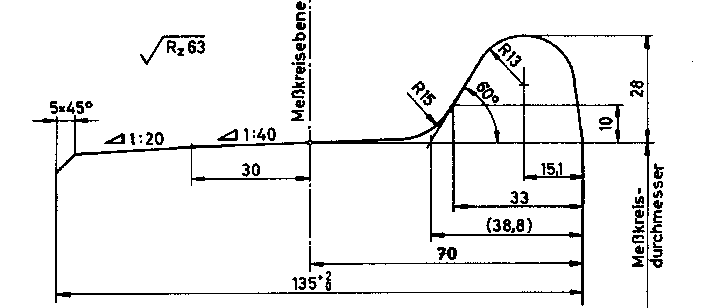
Many factors influence the type of wheel profile that an operator may choose to use on their trains. These include the curvature of the infrastructure, the design speed and the type of rail. Generally, for light rail applications, coned wheels are used in order to navigate tight curves. On Link, the wheel profile is a 1:20 taper.

Coned wheels connected by a rigid axle allow rail vehicles to steer around curves by creating a differential in rolling radius. When in a curve, the inside wheel rotates with a smaller radius, and travels a shorter distance, than the outside wheel. This differential reduces friction and flange contact, reducing wear on the wheels and the rails.

Coned wheels also provide lateral forces that keep the rail vehicle centered along the railway and prevents flange contact, reducing both wear and the risk of derailment. If the train shifts to the right, the rolling radius difference steers the train back to the left, then back to the right, etc. The side-to-side movement is eventually damped and the train will become centered again. However, it only does so below its intended design speed.

The lateral forces of coned wheels increases with speed. Above a “critical speed”, the higher lateral forces begin to overcompensate when the train becomes off-center from the tracks. The damping effect that allowed the train to become stable at lower speeds is overcome by the higher lateral forces. This leads to a continuous side-to-side motion called hunting oscillation, which if not mitigated, leads to flange contact, excessive wear and even derailment.

As a result, many trains that operate at speeds higher than light rail vehicles don’t use strictly-coned wheels. While Link vehicles use a 1:20 taper, a German standard wheel profile DIN 25112 Type C used for conventional rail contains a 1:40 taper for most of the contact surface, with 1:20 only towards the outer edge. At higher speeds, this reduces lateral forces, but allows for stabilization when lateral movement is extreme.

However, the situation becomes even more complex. The wheel profile must also be accommodated by the shape of the rail profile themselves. After all, it’s the interaction between the rail and the wheel that determine vehicle dynamics. It is in fact possible to use rail profiles that support higher running speeds with 1:20 wheel tapers. On the other hand, a flatter wheel could also show excessive wear on un-optimized rail profiles.

Amtrak’s high-speed Acela trains, which operated on tracks with more curvature than other high speed systems, showed increased flange wear as a result of wheel profiles that were not optimized for the rail profiles.

The takeaway here is that generally, coned wheels are less stable at high speeds, but railway profiles can be modified to achieve a conicity that allows for higher speeds and lower wear. The trick is to make sure that new infrastructure is designed for the rail vehicle(s) using it, and that existing infrastructure is modified (if necessary) before new vehicles enter service. If high performance is required, then it has to be designed into not just the structure and alignment, but also the wheel-rail interface.

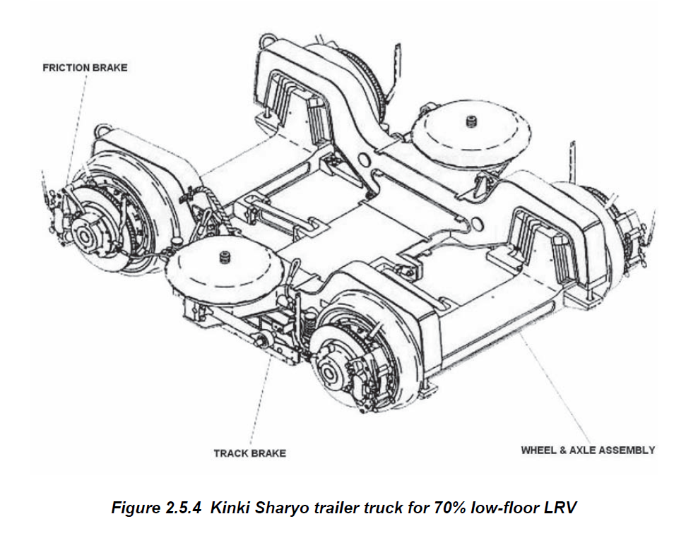
Independently rotating wheels (IRW)

Light rail vehicles like Link contain double-articulation using a short center trailer. To achieve a low-floor design in the middle of the train, the axle is removed, allowing the wheels to turn independently from one another. The combination of short center trailers and independent wheels has a few implications. We’ll discuss a few from this study sponsored by the Federal Transit Administration.

Without an axle, the self-steering mechanism that stabilizes the vehicle (in this case the center trailer) is removed. Coned or not, the wheels are free to rotate independently of one another, which means it no longer self-steers towards the center of the track.

As a result, flange contact becomes more common with IRW systems. In some situations, such as tight curves, turnouts or even when travelling at higher speeds on straight tracks with unevenness, the trailer may be guided by the flanges of the wheels rather than the rolling radius differential. This contact increases friction, wear and sometimes noise.

NJ Transit reported “higher wheel wear on the center trucks of its LFLRV fleet than on the wheels of the motor trucks” and “very high rail wear on sharp curves.” Portland Trimet came to a similar conclusion, reporting that “Portland MAX has experienced higher LFLRV wheel flange wear on the center truck than on the motor trucks.”

At its worst, the forces generated through this increased flange contact may be high enough to let the wheel climb over the tracks and cause a derailment, and the report notes:

Trucks with IRW center trucks are, therefore, fundamentally more susceptible to derailment and, as a result, their behavior can be strongly influenced by other factors, which would normally be of only secondary importance for trucks with solid axles.

As with any engineering issue, there are methods for mitigation, including modification of infrastructure for better wheel-rail interfaces and maintenance. Wear and noise can be mitigated using several methods, including lubrication, which Sound Transit has done. Additional protection through curves could also be provided by restraining rails. Operationally, the report also suggests that curves should be taken at constant speeds, with acceleration only after the curve has passed. Finally, improved vehicle and infrastructure design can also reduce these negative effects. Manufacturers and operators like Sound Transit have surely learned much more since this report was presented (2006).

However, the need for these mitigation measures demonstrate that for light rail, “track standards have to be tighter than might be acceptable with more conventional vehicles. It is also generally recognized that the management of the wheel/rail interface is even more critical.”

Generally, this means that it is more difficult for light rail to achieve the same performance (speed, acceleration, curving capabilities, etc.) compared to a conventional train.

By the way, some of you have mentioned other rolling stock that use IRW systems, yet operate with high speeds, such as the Alstom Citadis and WSDOT’s own Talgo trainsets. Alstom’s Citadis is an example of a 100% low-floor tram that can operate at high speeds, but the wheels are connected by a low-level driveshaft linking the wheels together, which do not make it a true IRW system. Talgo’s trainsets use a passive steering mechanism to overcome the lack of rolling radius differentials supported by an axle.

Implications for Link

So how does this apply to Link? The purpose of this document is to demonstrate the complexities that result from designs specific to light rail and to show that it’s not simply just a vehicle on rails that happens to bend well.

My previous article suggested that light rail may not be the best solution for regional services. On a 60-mile regional line, vehicle performance (speed and acceleration) influences not only travel times, but also travel time reliability.

Many comments pointed out that there are light rail vehicles available to provide higher performance necessary for regional transport. For Sound Transit to order new light rail vehicles with greater performance at this time may turn out to be an extremely complicated process.

First, it would have to determine what kind of performance increases would both reduce travel time and improve reliability. Next, it would need to work with manufacturers to determine if a vehicle is available to provide these needs. Then, they must together determine whether the new vehicle or the track infrastructure requires modifications. Increasing the speed changes dynamic forces, and dynamic forces require mitigation. Finally, if the changes to the infrastructure are necessary (rail grinding, wheel profile modifications, etc.), they will have to be applied and not at a low cost.

Operational requirements should dictate the type of vehicle that is used. The infrastructure is then built to support the vehicle.

In Seattle, low-floor light rail has been selected to provide flexibility in city centers. The infrastructure and the vehicles have been designed to operate below freeway speeds, much slower than cars and buses except during congestion. What our light rail system lacks in performance though, it makes up for in urban flexibility. Urban areas is where its capability shines.

Perhaps Sound Transit is willing to figure this out. They may be willing to work with manufacturers and procure higher-performance light rail vehicles that fit our infrastructure. Or maybe they’ve already considered all of this and the tracks are ready to support the next-gen Link train. That’s something we can’t say yet, but it’s certainly worth having a discussion about, especially when a chunk of a $15 billion package is potentially on the line (pun intended).

For now, however, by pushing our light rail system as it is to operate regional services between Tacoma and Everett, it may not offer the type of performance that regional services need and deserve.

Limitations of light rail as regional transport (Part 2)

In part 1, we discussed how the limitations of our light rail system may impact its performance as a regional service. Now, we will highlight some potential issues within cities that we may face when our light rail capacity is adapted to serve high-demand suburban services.

Light rail’s need to provide high capacity and reliable mobility for the region is supported by its infrastructure. When the infrastructure means “surface running”, such as on MLK, high capacity (i.e. longer trains) is accommodated by large stations and reliability is provided by long stretches of track with uninterrupted travel. Although this means that mobility to and from the neighborhood is improved (regional mobility), accessibility within the neighborhood may be compromised.

Mobility vs accessibility

Transport engineers like to focus on mobility, which characterizes the movement of people or goods. It is a means to an end, in which mobility is required for a person to perform an activity that takes place somewhere else.

On the other hand, land use planners like to focus on accessibility. This has several definitions, but in the context of urban design, it defines the ease at which activities can be performed.

Let’s take a look at Jarrett Walker’s definition:

“Access is how many useful or valuable things you can do.”

And let’s take a look at Litman’s:

“Accessibility (or just access) refers to the ability to reach desired goods, services, activities and destinations (collectively called opportunities).”

Now there’s an important difference between mobility and accessibility. While accessibility focuses on the ability to perform activities, mobility focuses on the means to get there. If an activity is closer, it requires less mobility, and thus the accessibility may be higher. Jarrett Walker also notes this:

“If a new grocery store opens near your house, that doesn’t improve your mobility but it does improve your access.  You can now get your groceries closer to home, so you don’t need as much mobility as you did before…A lot of the work of access is simply about eliminating the need to move your body around the city in order to complete the economic and personal transactions that make up a happy life.”

The ability to perform activities within a neighborhood (accessibility), is fundamental to urban design. How can residents in a neighborhood perform their daily tasks as easily as possible, without the need to travel long distances and without the need for motorized transport?

This is achieved using various ways, among them, higher density developments, narrower streets and more pedestrian access. The solutions are up to the planners, but they often hint towards some kind of compactness in the neighborhood structure that shortens trips and allows activities to be brought closer together. The infrastructure within the neighborhood has to support that.

Limitations to accessibility presented by high-capacity light rail operations

While Link will bring mobility to surface segments (i.e. Rainier Valley) as well as some Transit-Oriented Development, its design places a limit on accessibility when it runs on the surface. It can take people farther away from the neighborhood, and it can generate development around the station, but it doesn’t allow trips to be as compact as possible within the neighborhood. This is notable in surface running applications such as on MLK.

One of the touted capabilities of our light rail system is its capacity, not because of its frequency, but because of its ability to run 4-car trains. This is necessary to support demand elsewhere in the network, but not necessarily in the Rainier Valley.

In grade-separated operations, the ability to run 4-car trains is a plus. However, on surface streets such as MLK or the planned Bel-Red corridor, this may become an issue for accessibility.

A 4-car train totals just over 380 feet (116 m) and the surface stations (such as those on MLK) built to support them meet or exceed 600 feet when ramps and access points are taken into account. Our light rail stations surpass the length of a typical downtown Seattle block length and conflict with components of accessibility. These stations are fenced off on both sides, and prevents access from any point other than the ends of the blocks they sit on. The infrastructure needed to accommodate the train’s sheer size represents a large barrier in the middle of MLK and enforces the distance residents must travel to get to “the other side”. The train itself may be accessible, but a trip starting from mid-block and ending on the opposing mid-block is separated by more than 600 feet, even though it is physically not more than 100. It removes connections across MLK, connections that will become even more important when TOD is built around the stations.

And then there is the long distances between intersections. Between S Orcas St and S Graham St, there is only one pedestrian crossing over a span of nearly 2000 feet.

These compromises are the direct result of Link’s attempt to serve both the region (through a 60-mile corridor) and urban neighborhoods (street running). It needs the reliability provided by uninterrupted movement through the corridor, but on street-level, that requires minimal intersections and pedestrian crossings. It needs the long platforms that can handle 4-car trains to meet demands elsewhere in the network, but occupies large footprints in what is to become the center of TOD. Where Link strives to provide mobility for the region, it does so at the expense of neighborhood accessibility.

If surface rail is aimed at complementing mobility, it should be scaled to support it. But in this case, Link is scaled for the need to provide mobility out of the neighborhood, rather than complementing the neighborhood in which it operates.

So what exactly are we building?

This is a question we need to answer, even if it may already be too late. Are we building a light rail system that satisfies the mobility needs of Seattle and its immediate suburbs? If so, our sizable trains that try to meet regional needs may negate the accessibility benefits when it runs on the surface. It also doesn’t serve enough of Seattle to satisfy urban mobility needs and instead, ventures out into the suburbs with a stop every 2 miles.

Does that mean we are building a regional network to connect cities in the Puget Sound region quickly and reliably? That too is questionable, because in that case, we are pushing the very concept of light rail beyond its intended use, where it may not keep up with the performance demands of regional services.

Urban mobility and regional connections are two completely different concepts that each require their unique solutions. Urban mobility is provided by an urban or suburban network with high capacity, frequency and accessibility to facilitate short trips within an urban area. Regional mobility is provided by high-performance trains that can travel between multiple cities quickly and reliably. These two concepts conflict in many different ways.

Unfortunately, it appears that we are trying to serve urban, suburban and regional needs with one mode, and in the end we may get something that serves none of them particularly well.

North by Northwest View 16: Quit With the “Road Diets”…

Yeah, those silly “road diets”.  According to WikiPedia, road diets are:

A road diet, also called a lane reduction or road rechannelization, is a technique in transportation planning whereby the number of travel lanes and/or effective width of the road is reduced in order to achieve systemic improvements.

Actually road diets are Beyond Stupid.  Just as much as putting more lanes on I-5… Recently the Washington Policy Center’s Bob Pishue punded away:

As Sound Transit officials prepare to take over the center lanes of I-90, their newest online advertisement asks the question, “What’s to do when we’re running out of roads?”(Their edited clip was originally from a video promoting highway building.) Unsurprisingly, their answer is to build light rail.

Yet they completely ignore the fact that public officials have continually pushed to make the public “run out” of roads. State officials are reducing the six-lane viaduct to a four-lane tunnel, guaranteeing traffic snarls around Seattle. Sound Transit is taking away the center lanes of I-90 for light rail, which the State Department of Transportation estimates will increase traffic congestion despite restriping the outer lanes. Seattle’s leaders have added to gridlock by handing over roads around the city to streetcars, transit, and bike paths. Instead of providing more general purpose access on the new SR-520 Bridge for the traveling public, state lawmakers opted instead for a new bike path and HOV/transit lanes.

Getting around is already tough out there, but it gets even tougher when public officials take away road access then say we are “running out” of capacity.

According to the aforementioned WikiPedia article, road dieting also is a problem for buses:

Road diets can negatively affect the speed and reliability of transit service operating on the roadway, particularly if bus stops are located in pullouts and traffic queues delay buses attempting to re-enter traffic. Constructing bus bulbs can mitigate these effects though this feature results in delays for other vehicles.

So what do we do?  Well then:

  1. New road lanes have limited effectiveness
  2. Use better the roads we have – and if road dieting is about safety, then reduce the speed limit
  3. Never forget real congestion relief is mass transit
  4. Require new facilities like museums & airport terminals have baked in transit structural & scheduled capability.

Does This Sign Belong to You? If so, could it be updated?


I happened upon this sign while visiting SafeCo Field today. Some interesting problems with this sign, mostly as a result of it being dated.

– It refers to CenturyLink Field as Qwest Field.
– The Greyhound Bus Terminal is in the wrong location (it moved!)
– Chihuly Garden and Glass  (currently the #1 thing to do in Seattle on Trip Advisor) is nowhere to be found.
– The MOHAI is missing too (#23 on Trip Advisor).
– It designates the “Ride Free Area” for buses, which no longer exists.
– It tells you where buses run and roughly how often, but gives no indicator of where these buses go.

You may think of this as nitpicking a sign (and I am!), but it may be useful to think about what is the purpose for this sign. In 2015, the only folks who really need this sign are folks that don’t have smartphones — locating the Greyhound Bus Terminal in the wrong location could be quite catastrophic for someone trying to find it to catch a bus. Likewise, telling a visitor to town that you can ride buses for free downtown could cause them an expensive ticket (if they got on the RapidRide buses, as an example).

Who does this sign belong to? I’m guessing some department of the city of Seattle? What are the goals of signs like these in 2015, and are they meeting them? And how can they be kept up to date in a fast developing city like Seattle?

West Seattle-Downtown-Ballard Transit Service in 1985

If you have complaints about the current service provided by RapidRide C or RapidRide D, just be glad you didn’t try to commute from West Seattle or Ballard to downtown 30 years ago using Metro routes 15 or 18.

The maps for the 15 and 18 show that their 1985 routings hadn’t changed much from 1941 when those routes were established as part of the original electric trolley network. Both routes added service north of NW 85th Street when they were dieselized in 1963, but those are the only obvious service additions I can see. The 1941-63 trolley version of route 18 did have 2 branches south of Morgan Street in West Seattle: the 18 Fauntleroy as pictured in the link above and the 18 Gatewood which is today mostly covered by route 22. The 15 West Seattle also had 2 branches in West Seattle: the branch to Alki that is shown in the 1985 map and another branch that was routed through the Admiral District/Genesee Hill area (similar to the current route 57). The bifurcated versions of the 15 and 18 in West Seattle continued to be operated by diesel coaches until 1978 when the Genesee Hill and Gatewood segments of the 15 and 18 were combined into a new route (the 49).

In 1985, the 15 and 18 followed identical routes from approximately Harbor Island to just north of the Ballard Bridge. Together, they provided local service on 1st Avenue South in SODO and operated through downtown Seattle on 1st Avenue to the Seattle Center and Ballard. Midday headways on both routes was 40 minutes, which provided service every 20 minutes for Interbay, downtown and SODO; but Alki, Fauntleroy, 15th Avenue NW and 24th Avenue NW only saw a bus every 40 minutes. Today, most of those corridors get headways of 15 minutes or less.

At night, service on route 18 improved to 30 minute headways, but route 15 was served by the always unpopular Night Shuttle service. On the north end, the 15 operated only from Blue Ridge to the Ballard Bridge on a schedule that created a timed meet with the 18. The riders on route 15 would then transfer to the 18 to complete their trips to Interbay, Seattle Center or downtown. Going from downtown to 15th Avenue NW required catching the 18 in downtown Seattle and transferring to the 15 Night Shuttle by the Ballard Bridge. On the south end, a similar transfer point was established near Harbor Island. The 15 shuttle buses were supposed to always wait for the 18 before leaving the transfer point, but I can testify that there were plenty of times when the Night Shuttle bus left without waiting for its transfer load.

Today, 30 years later, the 15 and 18 network has been replaced by a number of frequent service routes. RapidRide C, RapidRide D, the 40 and partial service from the 21 have all replaced segments of the service provided by routes 15 and 18 in 1985. Plus, we’re seriously entertaining plans to build frequent light rail lines to both Ballard and West Seattle. I wonder how much progress will be made in the next 30 years.

North by Northwest 60: Update on the Tri-County Connector Crisis

Boarding an Island Transit Tri-County Connector 411W Bus at March's Point, Anacortes

AvgeekJoe Photo: Boarding an Island Transit Tri-County Connector 411W Bus at March’s Point, Anacortes

Folks, the future of the Tri-County Connectors is uncertain but I promised you an update.  As you may know, Representative Dave Hayes has put on the table a modest proposal to, “provide $1 million to restart an important bus transit route that, until last June, operated between Camano Island and Everett.”  The catch is that fares must be charged to access the money.

Recently, the Island Transit Board had a discussion about this and is tentatively supportive of Representative Hayes’ efforts:

One thing worth noting is that it’s now 21 April and no final decision has been made even to keep the County Connectors going.   Island County Commissioner Jill Johnson (Republican) is really attempting to force the beginning of public hearings on the service change with more passion and vigor than Island County Commissioner Rick Hannold’s (Republican) pontificating bordering on rambling about the need for a fare.

One should note that come Friday will be 67 days before the possible end of this service.  Sixty seven days.  Yet it seems Island Transit Board has been timid since knowing there was a crisis in November.  At least Island Transit staff have a contingency plan if there is no state support.  If I may quote from my recent feature on the Tri-County Connector crisis:

…These proposed connections are highly problematic.  That’s if Island Transit Board … decides to keep the Island County Connector.  One option, called “Proposal 2” and page four (4) of this Scribd link shows a proposal to only serve Deception Pass.  For Skagit Transit (Skagit County’s county level transit net), they’d have to make it to Cornet Bay to link up with Island Transit at all.

The other option best explained on page 8 shows a schedule that allows commuters to get off the main islands of Island County, but not necessarily get back.  Commuters seeking to leave Whidbey would have to be ready to accept a 3 PM departure from Harbor Station, Oak Harbor to arrive at Skagit Station at 4 PM.  The bus would then depart at 4:10, run to Camano and arrive at 4:40 PM – passing the bus going the other way.  To get from Camano to Whidbey you’d have to leave Camano at 3:30 PM, arrive Skagit Station at 4:05 PM, then leave Skagit Station, Mount Vernon at 4:15 to arrive at Harbor Station, Oak Harbor at 5:15 PM.  So if you work in Everett and need to get to Camano in the afternoon but miss that first northbound Skagit Transit 90X connection from Everett to Skagit Station, Mount Vernon which supposed to arrive at 4 PM but can easily be delayed… you are totally stranded.

So what is the solution?  One option may be delaying these runs until starting at 5 PM or 6 PM.  There already are plans for a northbound run starting at 6:35 AM and another southbound run at 6:45 AM.  Or chucking the 9:35 AM northbound & 9:55 AM southbound routes and making another late afternoon or early evening run.

With this Proposal 1 in play thanks to Representative Dave Hayes, the focus should be on commuters.  Doubly so with fares being required to get the $1 million state match for the biennium.  Gone are the days when a $6 million biennium start-up grant could be lobbied for this route.  Make sure to e-mail info-at-islandtransit.org your thoughts on this

But even with the recent fiasco around ORCA & Link Light Rail, I’m sure many of you would agree with Representative Hayes, “Riders need to have skin in the game.  All other transit systems are charging a fare. Many people who were using the Island Transit Everett Connector before it closed told me they would have gladly paid the fare, especially if it would have kept the route open. They’re willing to pay, so this amendment makes that a requirement in order to release those funds.”

Ultimately, let’s hope Friday the Island Transit Board will at least commit to the route and public outreach.  67 days to go… with a state legislature giving signals of going into indefinite deadlock over budgets.


In other Island Transit news, Oak Harbor Mayor Scott “Studley” Dudley who is widely credited with removing Martha Rose from the Island Transit Executive Director position last year is not seeking reelection due to his inability to work with the Oak Harbor City Council.  However, former Island Transit Boardmember Jim Campbell who graciously resigned from the Island Transit Board last year will give current Oak Harbor City Councilman Bob Severns a run for the money in the quest to be Mayor of Oak Harbor, Island County’s largest municipality.  If the Whidbey News-Times newsroom are worth their salaries, they’ll ask about Island Transit.

It’s safe to say North by Northwest would have endorsed “Studley” for Mayor based on cleaning Island Transit up and forcing the discussion of new revenue streams to Island Transit.  His looming presence and legacy in the Island Transit debate will be deeply missed.

LINK service patterns with a “Ballard Spur”

There has been some talk about how to serve Ballard with light rail in the future. There have been suggestions for a route running north from downtown to Ballard, and for a “spur” running west from the UDistrict to Ballard.

Advantages of a direct line from downtown:

-shorter Downtown Ballard travel times
-areas in-between, like Belltown, Denny Triangle/SLU, and Lower Queen Anne can be serviced

Advantages to a line running west from Brooklyn station:

-faster service alone 45th Street corridor
-would create both north-south and east-west lines in north Seattle. The entire north Seattle bus network could be redesigned so that every bus route serves at least one LINK station. Presumably, many could serve two (for instance, a bus route could connect Northgate to a stop on the Ballard spur)

If a Ballard spur were built, I first thought it should be a separate line, and not be interlined with other routes. However, I really only think that would be a good option if LINK service were always super-frequent. I now think it should be interlined with other LINK lines. So this is my proposal:

Ballard spur service

Ballard spur service proposal

There would be four lines:

1. Angle Lake (or whatever the southern terminus is) – Lynnwood (the current “Central Link” plans)
2. Redmond – Lynnwood (the current “East Link” plans)
3. Angle Lake/southern terminus – Ballard
4. Redmond – Ballard

These are my proposed service levels. No longer would there be less frequent service before 6am or after 10pm:

Peak hours: -each line would run every 12 minutes
Off-peak hours: -each line would run every 20 minutes

This would result in the following headways:

Peak hours:
-ID station – Brooklyn station: -every 3 minutes
-Angle Lake/southern terminus – Brooklyn station: -every 6 minutes
-Redmond – Brooklyn station: -every 6 minutes
-ID station – Ballard: -every 6 minutes
-ID station – Lynnwood: -every 6 minutes

Off-peak hours:
-ID station – Brooklyn station: -every 5 minutes
-Angle Lake/southern terminus – Brooklyn station: -every 10 minutes
-Redmond Brooklyn – station: -every 10 minutes
-ID station – Ballard: -every 10 minutes
-ID station – Lynnwood: -every 10 minutes

The only drawback to my plans compared to the current plans would be less frequent service between Brooklyn and Lynnwood. However, I believe that it is worth it to serve Ballard, and to provide one-seat service from Ballard to as far as Angle Lake/southern terminus and Redmond.

Proposed stations:

-45th/I-5 (entrances at both 5th and 7th Avenues)
-45th/Wallingford Avenue
-45th/Stone Way
-45th Aurora (entrances at about Winslow Place and Linden Avenue)
-NW Market/3rd Avenue
-NW Market/15th Avenue
-NW Market/24th Avenue
-NW Market/32nd Avenue

North by Northwest 59: Polite Reminder on Everett Transit Service Change…

Your Mr. North by Northwest is slammed this week, so between the big comment thread from Sunday’s open thread on the main page and my workload, I’m just going to take five to post a polite reminder of the last two Everett Transit the August 2015 service change planning meetings:

Monday, April 20, 2015
5 p.m. – 7 p.m.
Everett Station, Dan Snow Room
3201 Smith Avenue

Tuesday, April 21, 2015
10 a.m. – 12 p.m.
Everett Public Library, Evergreen Branch
9512 Evergreen Way

I come down on the side that since money is being spent on these public meetings by the transit agencies we cover, maybe we at Seattle Transit Blog should be advertising them… and encouraging attendance.  Whether it’s to discuss the service changes, give an atta-girl (or atta-boy), or concerns with the agency in question; methinks we’re cheerleaders for transit service.


Programming Update: Whidbey-Skagit-Snohomish Tri-County Connector update tomorrow, I promise now that I’ve got the video.  After-action report from this meeting sometime this week…

Georgetown service in 1975: 23 South Seattle

The 23 South Seattle in 1975 was a very basic route between downtown Seattle and Georgetown. The 1975 schedule and route map show 30 minute headways throughout the day with a couple of extra peak hour trips for riders headed to or from the industrial areas along Airport Way and the residential area in Georgetown. The 23 South Seattle route map from 1975 is very similar to the routing of today’s Metro route 124 between Georgetown and downtown Seattle. The main differences are that the 23 served Georgetown via a Flora Avenue/Carleton Avenue loop and that the 23 entered and exited downtown Seattle via Dearborn/Airport Way (perhaps to connect the Atlantic bus base with downtown) instead of via Holgate/6th Avenue.

Today, Flora Avenue is a very quiet neighborhood street and the buses that serve Georgetown (Metro routes 60 and 124) operate one block over on Ellis Avenue. A few years ago I was in Georgetown and I noticed that there still are still some ghostly remnants of curb paint along Flora Avenue where the 23 South Seattle bus stops were once located.