Transit Report Card: Ottawa

Gattineau and Ottawa buses crossing the Rideau Canal

I recently returned from a week-long trip to three of Canada’s great cities, of which two have already been covered by previous Transit Report Cards (Vancouver and Montreal). While I may return to write about the latter, which has since undergone some significant changes in wayfinding, today’s transit report is focused on the third and final stop on my journey: Ottawa, the national capital.

Ottawa’s transit system has some interesting quirks, namely its reliance on an extensive system of dedicated busways (named the Transitway) and its impending switch to light rail in the coming weeks. Some of its quirks are quite familiar to those of us in the Puget Sound region, as shown below, but I think there are some good lessons that can be learned from the system that OCTranspo (the city’s transit operator) has developed.

Segments ridden:

  • Trillium Line (diesel light rail) – Bayview to Greensboro
  • Various Transitway routes – Fallowfield to Downtown to Blair
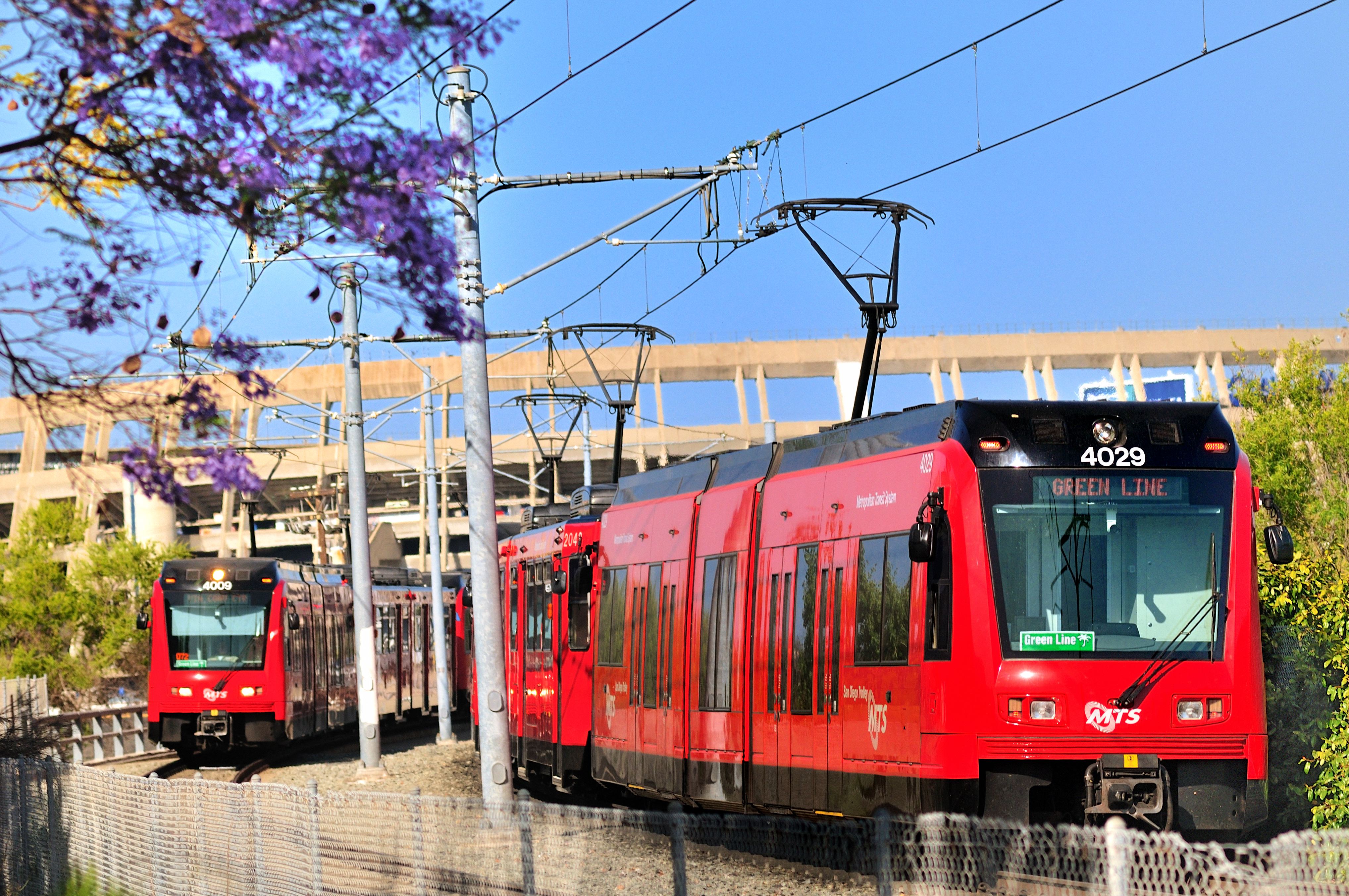
  • Route 18 – Downtown to Byward Market
  • Route 44 – Downtown to Hull (Gatineau)
  • Route 101 – Hurdman to The Glebe
Continue reading “Transit Report Card: Ottawa”

Transit Report Card: Columbus

A COTA bus on High Street in Downtown Columbus

The series in which STB writers travel around to other cities and make wild generalizations about their transit and land use is back, with a slight change in venue. I visited Columbus and Detroit in mid-October for a Wikipedia conference and spent plenty of time on the buses and bikeshare in the cores of both cities, gaining a decent enough understanding of their mobility situations. That being said, both cities sprawl out a bit and I was only able to really see the urban cores and inner neighborhoods of both cities, so there may be perspectives on both systems that I’m missing out on.

First up is Columbus, anchoring the largest U.S. metro area without a single passenger rail service, as Amtrak had ceased service in 1979 and the streetcars were dismantled in 1948. Several light rail proposals have come and gone, along with plans to build a proper inter-city rail system across Ohio, and have only left us with nice fantasy maps and a city that still dreams of building a greater transit system.

Continue reading “Transit Report Card: Columbus”

Transit Report Card: Seoul

wikimedia
wikimedia
Last week I attended a conference in Seoul. After long days of, uh, conferring, I wandered the subways and streets of one of the largest Asian megacities.

Myeongdong
Myeongdong
For a great walking city, Seoul is a curiously bad walking city. Things are close together, and the side streets are narrow enough to be dominated by pedestrians (see above). But when there’s an arterial, you get something like this: Continue reading “Transit Report Card: Seoul”

Transit Report Card: Mexico City

Skyscrapers along Paseo de la Reforma, Chapultepec Park behind, and the high-rise suburban Santa Fe District in the far background.

Last week I spent a few days in the largest city in the Western Hemisphere, Mexico City. While walking its colonial streets and riding its expansive Metro, I was reminded of something I wrote shortly after ULink opened:

Done well, transit is is a public utility that improves life for the many but excites the passions of the few (sorry, fellow nerds). Good transit readjusts our baseline expectations onward and upward […] Transit’s highest compliment is when the magical becomes ordinary. Far better to be necessity than novelty.

Ordinary magic is indeed a good way to describe how it felt to move around Mexico City. On the one hand, the city has everything going against it. The compact colonial core is choked by endless sprawl on the periphery, with 8 million city residents surrounded by 16 million more in the suburban State of Mexico.  The city’s anti-urban boulevards – such as the 14-lane Paseo de la Reforma – rival in their hostile sterility the worst of the Champs Élysées. Cars also drive fast and with little regard for Vision Zero type sensibilities.

But in the context of the chaos on the surface, the Metro is a priceless gift to Chilangos, 140 miles of fully grade separated transit, with 195 stations on 12 lines. It is the 2nd largest Metro in the Western Hemisphere, behind only NYC. But though 2nd largest, it is the most densely ridden. Despite having only 60% as many track miles as NYC, the Mexico City Metro has 90% of NYC’s  ridership, nearly 5 million riders per day. I found it to be an effortless, cheap, fast, and reliable way to see the city, and I can’t imagine my trip without it. Here’s my report card. Continue reading “Transit Report Card: Mexico City”

Transit Report Card: Glacier National Park

IMG_2572
Mt Piegan from the Siyeh Pass Trail

I’ve just returned from a weeklong vacation in Glacier National Park, and though I didn’t intend to think much about transit while there, I was more than pleasantly surprised by the effectiveness of the park’s bike, bus, and rail options. Glacier draws 2.3m visitors per year despite its remoteness – the nearest large cities (Calgary and Spokane) being 175 miles away – a feat that makes its carfree options all the more impressive. For reference, despite being a full hour closer to its nearest major city, Glacier draws nearly twice as many people as Mt Rainier.

Unlike Rainier or Olympic, which are primarily wilderness parks with few roads or services, Glacier stands out for a more European Alps feel: staffed backcountry chalets, multiple ferry services, 3 intercity rail stations, and a major road (Going to the Sun) bisecting the park from west to east. In the spirit of our Transit Report Card series, here are a few of my anecdotal observations.

Segments ridden

  • Horizon Air outbound to Kalispell, Amtrak inbound to Seattle
  • National Park Shuttle between Apgar Transit Center, Lake MacDonald Lodge, Avalanche Creek, The Loop, Logan Pass, and Siyeh Bend
  • Cycling from West Glacier all the way to Logan Pass via Going to the Sun Road

System Map
System Map

Fare Structure: A+

Continue reading “Transit Report Card: Glacier National Park”

Transit Report Card: Washington, D.C.

WMATA 7000 series interior
The 7000-series cars: sleek, modern, filled with screens, and with clean floors.

It’s high time for a resurrection of this blog’s classic Transit Report Card series, in which STB writers wildly generalize another city’s transit system based on limited experiences.

I’m here to report from two separate car-free trips to Washington, D.C., home to the (in)famous Metrorail system. Over the course of two cumulative weeks in October and June, I managed to ride the entire 117-mile system, on a car of each of the seven fleet series, the near-infamous streetcar, a few Metrobus and DC Circulator routes, and Capital Bikeshare for good measure; unfortunately, I didn’t have quite enough time to fit any commuter rail service into my trip. The second trip also coincided with the first month of “SafeTrack“, a massive maintenance and repair program that is systematically shutting down and reducing service on a new segment every 2 weeks, give or take, until March (or longer).

Enjoy this ride-by review of the other Washington’s transit system, complete with a gallery at the end.

Segments ridden

  • All six Metrorail lines, all segments during normal service patterns
  • Metrobus: X2 (Downtown to Minnesota Ave), T18 (Rhode Island to Mount Rainier), 2A (East Falls Church to Ballston-MU)
  • Other Systems: DC Streetcar, Metroway, DC Calculator, Fairfax Connector routes 90 and 983, Capital Bikeshare

Scope: B+

The Metrorail system is the 2nd busiest rapid transit system in the country, and one of the oldest in the post-war class that nearly included Seattle. Since 1976, the network has expanded into 6 lines that sprawl across the District of Columbia, Maryland and Virginia, with stop spacing and park-and-rides in garages that make it a suitable commuter rail system. It covers most of the region’s major destinations, some of which developed around the system, and was a part of just about every trip I needed/wanted to make. A handful of popular places like Georgetown are excluded from Metrorail, but are not completely inaccessible if you know to use Metrobus and could be on the cards for a future expansion.

Continue reading “Transit Report Card: Washington, D.C.”

Transit Report Card: Denver

A brand new Denver Union Station

While visiting Denver in June, I thought I’d resurrect the old ‘report card’ series here on STB.

Denver may not seem to have much in common with Seattle. Sea level, water-bound, temperate, and hilly Seattle is a stark contrast to the Mile High, dusty, rain-shadowed, and flat landscape of Denver. But we are both relatively young pioneer cities, Denver is our nearest peer city in population, and both cities are progressive islands in a sea of moderate/libertarian suburbs. And yeah, we both have legal pot. So perhaps some comparisons can be useful.

As a transit advocate, it’s an exciting and informative time to visit Denver, which is in the midst of a once-in-a-century transformation. Light rail lines opened in 1994, 2000, 2002, 2006, and 2013, (and one was suspended in 2009), and six more light and heavy rail lines are slated to open in the next few years. The ongoing Fastracks project is the most ambitious transit expansion in the U.S., and the most intense period of construction is currently underway. When originally conceived, the project promised 119 miles of rail in every direction, all to open in 2016; and the original price tag, just under $5B, was 14 times cheaper per-mile than our University Link. Even when rising costs (~$7B now) and the recession pushed back portions of the project for years, many projects (The Gold Line, the I-225 Line, a small segment of the Northwest Line, and the East Line to Denver Airport) are still on track for 2016, and a shortened version of the North Line will open in 2018. Daily ridership on the 6 lines is 87,000 on its current 48-mile system.
Continue reading “Transit Report Card: Denver”

Maui Transit Report Card

mauibus2Maui is a small island and it’s bus system is likewise small. A service of County of Maui, it is operated by Roberts Hawaii.  There are basically two separate networks, a peak only commuter network and an all day network.

Of the thirteen all day routes, ten are hourly, two are every ninety minutes, and one is hourly in the morning and half hourly from 2:30 to 6:30pm.  The buses are new, clean, and have bike racks.  Fares are $2, cash only.  However since you only drop the bills into a clear plastic box and there are no transfers or change, boarding is quick.  All day passes are $4, monthly passes  are $45 and both are purchased from the driver.

You can’t really use the all-day to get around entire island as each route is only a few miles long and transfers are not timed.  For example one trip that ended up being less than thirty minutes by car would have taken three and half hours by bus and would have required one forty minute transfer wait and a one hour transfer wait.  Both the origin and destination were on the same road and less than twenty miles apart.

The commuter system covers almost the same area but combines all the short routes into four longer distance routes, radiating out from from the North/Central part of the island, mostly through the Wailuku/Kahului area.  Stops are reduced by about half.  Three routes have only one run each peak period, with one having four round trips.

As I only rode two all-day routes and none of the commuter routes I have to give Maui an Incomplete.  We were able to get by just fine without a car, but it required picking a hotel near our friends and close to services, walking most places, and relying on friends for the trip where we needed to go further than a few miles from our place.

Transit Report Card: Reykjavik

by CHAD NEWTON

Straeto Bus in Reykjavik
Straeto Bus in Reykjavik. Wikimedia user Jóhann Heiðar Árnason.

Overall Grade: C-

I had the great opportunity to visit Iceland for a few days last week. I found a nation blessed with natural wonders, an evocative history and interesting food. The capital city of Reykjavik has a compact core with world-class shopping, cuisine and nightlife. But the city’s all-bus transit system, Straeto, (there are no trains on the entire island) could use some improvement.

Straeto operates as if they visited U.S. Sun Belt cities to learn best practices:

  • Confusing mess of zigzagging, partially redundant lines? Check.
  • 30 minutes or greater headways outside of peak hours? Check.
  • Off-street transit centers? Check.
  • Opaque and contradictory public information? Check
  • General public unaware or uninterested in how to use transit? Check.
  • Faster to walk 30 minutes in town instead of using transit? Check.

On the plus side, the rolling stock is nice. Fold-up bench seating on one side provides lots of open floor area for wheelchairs or strollers, as is typical for Europe.

More after the jump. Continue reading “Transit Report Card: Reykjavik”

Transit Report Card: Seoul (II)

This is the second and final part of a two-part Transit Report Card series covering Seoul, the capital of South Korea.  In Part 2, I’ll explore transit in Seoul from a rider’s perspective and conclude with an overall assessment of the transit system in relation to the city’s urban culture.  You can find Part 1 here.

jongno3ga
Three stations in one: 16 exits. And you thought Westlake was complex?

System Design cont.: Wayfinding & Signage
As I alluded to in Part 1, Seoul’s transit system is an overlapping network of frequent services, many of which interconnect at points across the entire metropolitan area.  With millions of riders transferring between transit vehicles daily, infrastructure to accommodate these connections is crucial.  Given the enormous spatial complexity of its many stations, the city has does an excellent job in wayfinding and signage provision throughout its transit system.

Each subway line is numbered, color-coded, and designated by its terminal stations on wayfinding signs.  Connecting stations can be as far as a quarter-mile apart from each other, necessitating a complex labyrinth of connecting underground walkways, many of which act as secondary shopping corridors.  I was pleased to find vendors and merchants from street to platform, selling goods ranging from scarves to delimanjoo.

Many subway stations closer-in to Seoul are tortuously complex– station footprints are dotted with multiple points of access and egress.  Jongno 3-ga, for example, has 16 different exit and entryways, thanks largely to the interface of three separate lines.  As a result, multiple exits/entrances are numbered, each classified with nearby landmarks and destinations on wayfinding signs.

Continue reading “Transit Report Card: Seoul (II)”

Transit Report Card: Seoul (I)

hanyang univ. at ansan
Hanyang University at Ansan, Line 4

I’m continuing STB’s longstanding tradition of the Transit Report Card series, where a writer will review the transit and land use picture of another city after a visit.  I’m pleased to be kicking off the return of the series by thoroughly reviewing Seoul, South Korea.  Instead of assigning letter grades, I’ve opted to focus on in-depth observation and qualitative analysis.  You’ll also notice that I’ve deviated from the original subheadings in favor of new ones, which more appropriately classify the bits and pieces of my review.

Because the transit system is so vast, I’ll take the liberty of breaking up this report card into two parts, the first of which will cover the city’s planning background, and a general overview of the system development and design.  Part 2 will focus more on the rider perspective and cover things like fares, passenger amenities, local transit etiquette, etc.

Continue reading “Transit Report Card: Seoul (I)”

Transit Report Card: Toronto

ossington
Ossington Station, photo by flickr user tcp909

[This is part of theTransit Report Cardseries, in which writers generalize wildly based on short and limited experience with another city’s transit system.]

Segments ridden:
Yonge-University-Spadina (Yellow) Line: Glencairn – Union Station; Union Station – St. Clair
Bloor-Danforth (Green) Line: Landsdowne-Victoria Park
Various Street cars and buses.
Time ridden: Four days.

Scope: A-
The Toronto Subway has very good service where it does go, but that covers a fairly limited area. There are twomain lines, one that goes north-south in a “U” shape, and another east-west. There are also two short spur lines.

This Google maps overlay shows the area the subway covers. Each subway station has bus or streetcar routes that travel perpendicular to the line the subway station travels, forming a wonderful transit grid. This map shows the overall coverage, including buses and streetcars. If there isn’t a subway station or a streetcar line where you’re going, you’ll have find the nearest station, and then take the bus that travels perpendicular to the line and to your destination.

Service: A
Service is very frequent. Most buses had frequencies under ten minutes except late at night – many ran 24 hours – and the subway comes every few minutes.  Most stations had electronic signs to tell you when the next train was coming, but they were a mix of new LCD screens and some 30 years old or older, and many of the older models didn’t seem to work. Major bus locations also had next bus signs.

Routing: A
As far as I could tell (feel free to correct me in the comments), there are really only four major highways in Toronto (401, 427, 404 and “the Gardiner”), and those are mainly served by “bus rapid transit”, a service similar to ST express buses. Many of the rest of the bus lines are oriented around the subway, and the subway is mostly oriented in cardinal directions (N-S, E-W).

Grade/ROW: A
The subway is entirely grade-separated, and the streetcars have their own lanes in some places, as do some of the buses.

TOD: B
Downtown Toronto is a sea of modern skyscrapers, and there are many older, dense neighborhoods. Some outlying areas have become densely urbanized, such as North York. However, I was surprised single family homes with yards across the street from stations such as Ossington, just five stations from Bay station in the heart of downtown.

Culture: A
A surprisingly large number of people live in Downtown Toronto itself – apparently most of the over 2,000 skyscrapers in the city are residential – and the Toronto subway the beats the DC Metro for the 2nd most ridden rapid transit system in Anglophone North America at 910,300 people per day. The buses carry another 1.25 million, with streetcars carrying 300,000. Most commuters in the city either take transit or carpool. In the greater Toronto area, 22.2% of commuters take transit, according to the Canadian Census, compared to around 7.3% here in the Seattle area.

Continue reading “Transit Report Card: Toronto”

Transit Report Card: Montreal

[Editor’s Note: STB Founder Andrew Smith visits to resurrect our “Transit Report Cardseries, in which writers generalize wildly based on short and limited experience with another city’s transit system.]

Wikimedia

Segments ridden: (over seven days)

Green Line: from Lionel-Groulx to Viau
Orange Line: Snowdown-> Bonaventure, Lucien-L’Allier->Montmorency
Blue Line: Snowdown -> Jean-Talon
Yellow Line: Jean-Drapeau -> Berri-UQAM

Scope: B+

The 68-station Metro – Montreal’s rubber-tired subway system – has great scope for the denser areas of the city itself, and there are good commuter rail connections to the suburbs. As with most systems, buses fill in the gap for the areas not served by rail. Within the city, there are neighborhoods fairly far from the Metro and a bus transfer is required.

More after the jump.

Continue reading “Transit Report Card: Montreal”

Transit Report Card : San Francisco

Martin usually does the transit report cards. This time I’m posting about a place where I know transit fairly intimately.
Segments ridden:
Caltrain

Bart

Most Muni Metro Routes

The ‘F’ Heritage Line
Muni Buses

Scope: C+
BART covers the Eastbay well, parts of the San Francisco well, but only goes one station past the airport toward Silicon Valley in the Pennisula. Not only that, it doesn’t serve Marin County at all. In order to serve Marin, BART would need to be extended north and west across the city, and a bridge over, or a tunnel under, the Golden Gate would need to be built. So unless transit money gets a lot easier to come by, I don’t expect this to happen for a long time.

The Muni Metro’s six lines are something between Link and the SLU streetcar. They only cover the parts of San Francisco south and west of Downtown. The F Heritage Line does go along the Embarcadero waterfront to Fisherman’s Wharf, but that route is mostly for tourists and has relatively low capacity. The planned E Hertiage Line will continue to all the way to Fort Mason. There is a future plan to put the T Third Street into a new “Central Subway” that would cross the Market Street Subway and extend to North Beach, but funding for that extension has only been partially secured. Even then, the entire northwest portion of the city is only served by bus, though a BRT route has been planned for some of that area, currently Geary and Van Ness

Service: B+

BART runs in the City and downtown Oakland with five or six minute headways, but the suburban commuter portions have much longer headways, sometimes as long as fifteen or twenty minutes. BART runs from 5am to a little after midnight. Capacity maxes at 1500 per train. Muni Metro runs on ten minute heads at peak times, and service is from 5 am to about 1am. A single-car Muni train can hold up to 250 people, and a two-car train can carry 500.

Caltrain runs 98 trains per day, most of them local trains that stop at nearly all 28 stations. Some trains, designated “baby bullets” make just four stops, and there are other levels of express trains in between. ACE runs four trains per day, and Amtrak Capitol Corridor runs 32 trains per day.

Routing: B

Much of BART in the Eastbay runs near or parallel to highways, partly because of cheaper right-of-way, but also partly because of how these communities developed. In the 1960s and 1970s, building next to highways was all the rage.

Muni covers the south and west parts of the city well, most on that area aren’t farther than ten blocks from a Muni line or Bart.

The Pennisula toward the south is only served by Caltrain, which stops far from job centers in the South Bay and in the City. Caltrain runs parallel to 101, but through the historic downtowns. This routing is not perfect, but surface-rail corridors are difficult to come by. Many reverse-commute San Franciscans are taken from their Caltrain station to work by company-shuttle, and into city commuters are forced onto a transfer at Fourth and King station in San Francisco

Grade/ROW: B-
BART, like all third-rail systems, is entirely grade-separated. In San Francisco it’s entirely underground, and it’s also underground in Downtown Oakland, in Berkeley, and in a couple of the cities south of San Francisco, outside of that it’s elevated.

The Muni Metro is underground in the Market Street Subway, which makes for nine underground stations. Some of the other portions run in there own right-of-way, the new T-Third street is almost entirely in it’s own center street right-of-way, much like Link in the Rainier Valley. Ironically, the right-of-ways and subway sections of the Muni Metro are the major reason the Muni Metro still exists: in the 1940s and 1950s when streetcars were being taken out, the five lines that had their separated right-of-way couldn’t be replaced by buses.

The commuter rail lines, Caltrain, Amtrak Capitol Corridor and ACE, obviously run in their own right-of-way with grade crossings.

TOD: B+

San Francisco is the second densest city in the US, and easily the densest in the West. Many of the suburbs are also very dense: Oakland, Daly City and Berkley, among others, are in fact much more dense than Seattle is. Part of this is because of age of these areas, but there has been a lot of development around BART stations.

One of the main impetuses for the new T-Third street was the development of areas served by the line, including China Basin, Mission Bay, and Hunter’s Point.

Caltrain is running in a 19th-century rail corridor, so it runs through the historic downtowns of most of the cities it serves.

Culture: A-

San Francisco is one of the few cities in America where driving is not the majority. More than 35% of commuters take transit, and another 20% bike. San Francisco is also one of the few cities where nearly everyone knows where the transit lines are. East Bay commuters have been pushed away from driving by $4 tolls across the Bay Bridge, and reliable BART commutes. However, Marin County is only served by Golden Gate Transit, which runs relatively few buses, and most commuters along the Pennisula, in and out of San Francisco, still drive.

*************

San Francisco’s rail network is far suprior to Seattle’s, but the major modes are relatively analogous. Caltrain is like Sounder, BART is what Link could be with expansion, and I think the Muni Metro is a major inspiration for Seattle’s Streetcar network. One thing Seattle can learn from Muni is that two-train stations are worth it; you never know when transit demand will out-pace supply by huge amounts.

BART can also be a lesson: make sure to get commitment early when building transit systems. Marin County to the North dropped out early in the BART planning process, making it virtually impossible to extend BART there now, and Santa Clara county, to the south, now wants BART, but is forced to build it through the East Bay because San Mateo county was so opposed to BART. Also, duplicating highway corridors by may be the best way to serve current population and residential centers, but does not create future transit-orient development to the same extent new corridors might.

Also, Caltrain has 98 runs per day compared to 18 for Sounder. But Caltrain gets just 37,000 riders per day compared to 11,000 for Sounder. How can you run more than five times as many trains, through a far more dense corridor and get fewer riders per run? It’s simple: charge a a reasonable amount to ride (fares top at $11 for Caltrain), go to downtown job centers (Caltrain stops at few), and provide adequate parking (I know, I know: more parking is heresy). ACE and Amtrak Capitol Corridor show that suburb-to-suburb rail can work, but it needs to go through job centers, and again, parking is hugely important.

Finally, density is important. San Francisco is dense, as are a number of the older suburbs. But the South Bay, where a lot of growth has been over the last twenty years, is very low density and sprawling. Same thing goes with the areas East of the hills in the East Bay. San Francisco could have absorbed more of that sprawl, but, like Seattle, made a choice to try to “perserve” the 1960s way of life. What happened? The 1960s way of life was lost, but along the way so was affordibility and scope. Now there’s a huge region that is difficult to serve easily by transit, has chronic “natural” challenges like wild fires and floods (we just get floods here), and surprising congestion. Our area still has a chance to avoid sprawl and geographic expansion on the level seen by the Bay Area, let’s hope we can get everyone on board.

I contemplated whether to write about the South Bay’s VTA system, but I decided that system was worth a post of it’s own.

Transit Report Card: New York City

Third in an occasional series where I wildly generalize about a transit system based on limited experience.

Segments ridden:
More or less all of the Manhattan Routes
D train to Coney Island & Downtown Brooklyn
7 train to Shea Stadium
Various approaches to Yankee Stadium
Bergen County NJ Transit Line (Waldwick – NY Penn Station)
PATH: Pavonia to 14th St
Staten Island Ferry

Scope: A+
If you’re reading this blog you probably know that the subway more or less blankets the city. But what you might not know is the extent of the commuter rail system, which covers all of Long Island, half of New Jersey and deep into Connecticut and upstate New York. Look for yourself; it’s truly massive.

And don’t forget the PATH subway system into New Jersey and run by the Port Authority, as well as the Newark and Hudson Shore Light Rail systems run by New Jersey Transit.

Service: A+
24-hour service on the subway, unparalleled anywhere in the world. As for commuter rail, I rode into the city on a Sunday and found myself with 36 trains a day in each direction to choose from.

Routing: A
Not an A+ because there’s very little in the way of routing that bypasses Manhattan. The city could use some ring lines like they have in Tokyo, London, and Paris.

Grade/ROW: A+
As with all third-rail systems, no pedestrian or auto is ever going to get anywhere near the track.

TOD: A+
New York has extreme density where there’s rail transit, not so much where there isn’t. On the other hand, the not-so-dense places would give the average resident of, say, Greenwood some sort of aneurysm.

Culture: A+
Undoubtedly, the city in America where it’s most foolish to own a car, unless you go into the outer suburbs a lot. If not here an A+, then where?

*************

If you have even a little bit of transit tourist in you, get thee to New York City before airfares go up again. Driving is a nightmare, parking can cost over $20 for a half hour (plus tax), and the subway system approaches perfection (unless you require wheelchair accessibility, as I discovered when trying to cart around a baby stroller on this trip).

If you’re a total cheapskate, get a hotel out in the suburbs and take the commuter rail in.

What’s a little frightening is that with all the transit options available, there used to be more. There are tons of transit tunnels and stations abandoned at the peak of the automobile age. The city tore down dozens of miles of elevated track in the last century as well. And yet the system still carries more daily riders that all the nation’s other systems combined.

Smart NYC travelers fly into Newark and take one of the various New Jersey transit options into the city, rather than suffering through a 2-hour AirTrain and Subway slog into Manhattan from JFK.

Multimodalism is at its best here. At Penn Station, for instance, you have Amtrak, PATH trains, commuter rail, 6 subway lines, and God knows how many buses all coming together in one gigantic terminal. The Newark airport has an AirTrain system that connects all the terminals with not only the car rental complex, but also a train station that supports both commuter rail and Amtrak.

This kind of integration makes it plausible to nearly eliminate “puddle-jumper” aircraft, since outlying residents can simply take the train to take advantage of the many destinations available out of the New York airports. I think this kind of thing is very useful as gas prices skyrocket and scarce landing slots have to be devoted to bigger aircraft.

I’m told there are a few traditional tourist attractions in the city as well.

Transit Report Card: Washington, DC

Second in an occasional series where I wildly generalize about a transit system based on limited experience.

Segments ridden:
Red Line: Shady Grove – Union Station
Blue Line: Springfield – Stadium/Armory
Orange Line: W. Falls Church – Stadium/Armory
Yellow Line: Gallery Place – National Airport
Green Line: Gallery Place – Navy Yard
Time ridden: You name it. I grew up here, so I can’t even begin to recapitulate it.

Scope: A
There aren’t a ton of places to go in D.C. and the surrounding area that you can’t get to via Metro, but it falls a bit short of the blanket coverage you see in New York. The vast majority of the service lies inside the Beltway (analogous to I-405) which has all kinds of benefits for preventing sprawl and allowing a car-free lifestyle.

Service: A
Service is frequent except in the wee hours. Message boards tell you when the next train is coming, in pretty much every station.

Routing: B
The Red Line in Maryland follows some major arterials, rather than the nearby freeway. That isn’t the case along the Orange Line in Virginia, however. Inside the beltway, where most of the system lies, there really aren’t enough freeways to even tempt planners to route along them.

Grade/ROW: A+
As with all third-rail systems, no pedestrian or auto is ever going to get anywhere near the track.

TOD: C
Revisiting this with a newly critical eye, the TOD is kind of disappointing. The city itself is really dense, which was the case before the Metro came. Although many stations are underground and therefore impossible to evaluate without stopping there, my limited experience in the Maryland and Virginia suburbs at the ends of the line is pretty disappointing. My read is that local authorities are really starting to get it, however.

Culture: A
For many suburbanites, driving to work is unthinkable. They’re certainly not deterred by park-and-ride fees approaching $5.00 a day, on top of a fare of as much as $4.50 each way. I don’t personally know any people that work in the city anymore, but what I gather from sources like Matt Yglesias is that in the core a car-free lifestyle is increasingly viable and popular as the city emerges from epic mismanagement a couple of decades ago.

*************

If you are visiting DC for the traditional tourist itinerary, there’s no good reason to rent a car. Driving and parking are difficult in the main tourist areas. The Metro goes right to National Airport, and there is straightforward bus service if you must fly into Dulles or BWI.

I happened to be in town the very day the USDOT reversed itself and gave the go-ahead to Dulles Rail. Having spent most of that trip in the Dulles Corridor, I can say that there’s tons of high-rise office space surrounded by parking. That’s a good sign, as it indicates that there’s tons of available real estate with mild zoning restrictions. Furthermore, it’s certainly interesting to see how the attitude of federal bureaucrats can change when the system is in their direct experience, while it’s “let them take buses” out here in the stix. But let’s give Virginia’s leaders credit for persevering in the face of really negative feedback.

In terms of sheer beauty, little in the transit world really comparesto a DC Metro Station. The underground architecture, while composed mainly of concrete, is roomy and appealing. Interestingly, as far as I can tell, exactly 0.0% of the capital expenditure was devoted to public art. If it were up to me, I’d encourage all transit systems to build intrinsic beauty into their architecture, rather than add some art of controversial value to each station.

I’ll finish with a brief anecdote. I attended a game at Nationals Stadium downtown, which was built half a block from the Navy Yard station. I was impressed with WMATA’s event management, with the nearest gate to the stadium being exit-only before the game and entrance-only afterwards. Additionally, there were lots of WMATA personnel around to direct the crowds in the station and make sure that every last car was packed to the gills. It was an extremely well-organized operation, especially considering the stadium had only been open for a month.

At any rate, I soon was waiting for a transfer at L’Enfant Plaza, when I overheard this conversation:
“The next train comes in eight minutes.”
“Eight Minutes?!”

Think of the implications of that conversation:
(1) The agency is able to predict with precision the next arrival.
(2) They inform riders with a simple-to-use message board.
(3) The riders are conditioned to think that 8 minutes is an unreasonable time to wait at 10 pm.

Jealous, aren’t you?

Photo courtesy of washingtontravelcast.com

Transit Report Card: Dallas

First in an occasional series where I wildly generalize about a transit system based on limited experience.Segments ridden: Commuter rail to Union Station, Red Line Union Station to Galatyn Park.
Time ridden: 6 pm to 9 pm on a Monday (with a stop in between)

Scope: C, could become an A
As a traveler, it was an extremely painful experience to take two shuttle buses to reach the commuter rail line, which only runs on the hour. On the other hand, the system opened only in 1996 with extensions to the airport (and elsewhere) planned. Wikipedia lists the system as 48.6 miles, not bad after 12 years of operation. So a C for now, but when built out it’ll be a really extensive system.

Service: C
The commuter rail runs throughout the day, which is nice. A quick glance at the DART schedule shows long operating hours and good peak service, but 20-minute headways in the middle of a weekday just doesn’t cut it.

Routing: B
The commuter rail shoots straight to Fort Worth by passing through some pretty undeveloped country. However, the Red line more or less follows the freeway without being right along it. This is the best of both worlds — highways in Texas tend to already have a lot of density around them, but the distance from the road allows walkable areas to develop.

Grade/ROW: C
Downtown, the rail ran in a converted city street, as in Portland. Most of the Red line is underground or elevated, although there are a few at-grade crossings.

TOD: D
Because of the proximity to the highway, there was some high density stuff, but there were plenty of stations with not much around them, and I saw little evidence of pedestrian-oriented development. The line is still young, so it might have a chance to improve.

Culture: F
Based on my admittedly small sample size, rail transit in Dallas is viewed as something that only poor people use.

On a visit to Texas, where gasoline comes out of the tap, I sure expected a lot worse than the DART system. I thought I might see a mild gesture towards giving people true mobility without cars, hamstrung by the same kind of half-assed measures Sound Transit opponents want to trot out. That wasn’t the case at all.

Although the at-grade downtown segment condemns the system to short trains and low capacity, the system seems to go where people want to go, and does it quickly. Aside from the downtown business, I would say the mix of grades is similar to LINK’s initial segment, and that’s pretty good as light rail systems go.

If you do fly into Dallas, I would strongly recommend taking an airport shuttle or taxi to your destination for the time being. The transit service for the airport is confusing, inconvenient, and very poorly marked.

If your itinerary happens to be oriented around where the lines happen to go, DART is a reasonable alternative to renting a car, although their highways make Seattle’s look downright rickety.

Image courtesy of http://www.winwaed.com