
It’s high time for a resurrection of this blog’s classic Transit Report Card series, in which STB writers wildly generalize another city’s transit system based on limited experiences.
I’m here to report from two separate car-free trips to Washington, D.C., home to the (in)famous Metrorail system. Over the course of two cumulative weeks in October and June, I managed to ride the entire 117-mile system, on a car of each of the seven fleet series, the near-infamous streetcar, a few Metrobus and DC Circulator routes, and Capital Bikeshare for good measure; unfortunately, I didn’t have quite enough time to fit any commuter rail service into my trip. The second trip also coincided with the first month of “SafeTrack“, a massive maintenance and repair program that is systematically shutting down and reducing service on a new segment every 2 weeks, give or take, until March (or longer).
Enjoy this ride-by review of the other Washington’s transit system, complete with a gallery at the end.
Segments ridden
- All six Metrorail lines, all segments during normal service patterns
- Metrobus: X2 (Downtown to Minnesota Ave), T18 (Rhode Island to Mount Rainier), 2A (East Falls Church to Ballston-MU)
- Other Systems: DC Streetcar, Metroway, DC Calculator, Fairfax Connector routes 90 and 983, Capital Bikeshare
Scope: B+
The Metrorail system is the 2nd busiest rapid transit system in the country, and one of the oldest in the post-war class that nearly included Seattle. Since 1976, the network has expanded into 6 lines that sprawl across the District of Columbia, Maryland and Virginia, with stop spacing and park-and-rides in garages that make it a suitable commuter rail system. It covers most of the region’s major destinations, some of which developed around the system, and was a part of just about every trip I needed/wanted to make. A handful of popular places like Georgetown are excluded from Metrorail, but are not completely inaccessible if you know to use Metrobus and could be on the cards for a future expansion.
Service: C+
Under normal circumstances, trains are fairly frequent during the day and one would not need to look at a schedule (not that there are any to look at). At night, however, frequency drops make transfers a bit of a hassle, especially when the stations aren’t in the best of shape or well-trafficked by security.
During my June trip, I stayed at a hotel in Tysons Corner near the end of the Silver Line in suburban Virginia, coinciding with the middle of SafeTrack work that single-tracked trains through the area. Silver and Orange line trains that I rode were subject to considerable delays and frequencies in excess of 18-20 minutes even at rush hour, resulting in serious crowding at Ballston and further along the heavily-developed Arlington corridor.
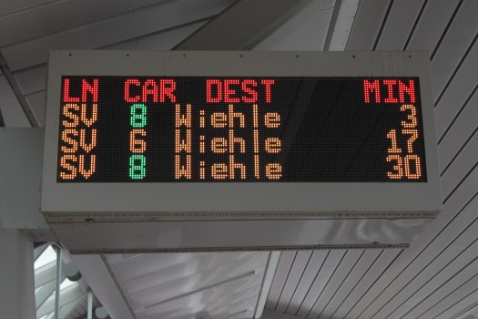
The passenger information systems at the stations are very good, to say the least. The signs at every station platform display the next three train arrivals in a given direction, with the line, terminus, and number of cars. The latter is given an additional feature in the form of colored numbers for 8-car trains, which allows passengers to spread themselves out a bit further along the 600-foot platform (aided by helpful stickers on the ground) or wait and gamble on what should be a less-crowded train.
The information once you boarded trains, however, was very lacking. All but the newest 7000-series cars are not guaranteed to have working text and voice announcements for stops, with operators using their poor PA system to barely say the upcoming station. I took to the habit of counting stops until my egress point, using signs at the stations to confirm the train’s location.
Transfers between Metrorail lines were easy enough with SmarTrip, the regional fare card, which I loaded weekly passes onto for unlimited rail riding to avoid some of the steep rush-hour fares.
Routing: B

Depending on the region, Metrorail either chose the most effective or ineffective routes to serve the region. In suburban Virginia, the outer reaches of the Silver, Orange and Blue lines use freeway medians to great effect, though they eventually switch to tunnels near Downtown DC. Thankfully, pressure from Arlington residents during the planning process routed the Orange and Silver lines under Wilson Boulevard from Ballston to Rosslyn, sowing the seeds of an excellent stretch of dense transit-oriented development.
Some of Metrorail’s outer reaches are freeway-running, utilizing the medians of Interstate 66, the Dulles Toll Road, and the Anacostia Freeway; other segments use railroad right-of-way that may parallel active tracks used by freight and passenger services (Amtrak and MARC/VRE); and some manage to still use tunnels, like at the eastern end of the Blue and Silver lines and the northwestern branch of the Red Line.
Grade/ROW: A

Metrorail runs completely grade-separated, as required of third-rail systems, and has a healthy amount of buffer space when it runs on the surface, separated by lanes of freeway or freight/commuter railways.
And speaking of commuter railways, the Virginia Railway Express (VRE) and Maryland Area Regional Commuter (MARC) both use shared right-of-way that is owned by CSX, Norfolk Southern and Amtrak. While this isn’t an ideal setup, it seems that delays are relatively minimal and weekday service is plentiful, unlike what we have with BNSF.
The final rail system in the region, the streetcar, runs completely in shared lanes that get a bit congested during rush hour, but are otherwise an acceptable choice of right-of-way.
Buses, of course run in mixed traffic, with a few bus-only lanes starting to come online (though not comparable to their 1970s network). They do, however, utilize shoulder-running buses much like we’ve started trialing and would expand under ST3.
TOD: B

For all its faults, Metrorail has forever changed the landscape of the DMV (District-Maryland-Virginia) region, with visible pockets of transit-oriented development sprouting up around stations across the system. Of particular note is the two main corridors in Virginia—the Ballston-Rosslyn corridor on the Orange and Silver lines; and the Pentagon-Crystal City corridor on the Blue and Yellow lines—which had a substantial amount of dense, mixed-use development that varied in age and size.

Out west on the Silver Line, Metrorail seems to be happening upon existing development more often than influencing new ones. Tysons Corner had been sprouting clusters of office buildings for decades, with no real hope for a walkable environment at street level. Even then, my “home” station, Spring Hill, was in the shadow of a brand-new 34-story luxury condominium tower sporting a parking garage podium taller than most buildings in the District of Columbia (restricted by a century-old height limit).
Even the new streetcar, which began running in February after years of delays, has started to attract some development. A walk around the eastern terminal to the north of RFK Stadium shows a lot of potential for revitalization and redevelopment of gas stations and strip malls to complement the neighborhood’s historic rowhouses.
Culture: B

Washington, D.C. is famous for its rail culture, with strict adherance to the “stand on right” rule on escalators. It is also well known for its apathy towards Metrorail and WMATA in general, with ridership starting to fall in recent years as other options have emerged. Overall, the other riders kept to themselves and were completely respectful of one-another, which is all that we can really ask for.
WMATA is not known for being a good communicator, especially during delays and incidents on the tracks. A legion of unofficial Twitter accounts instead relay information for riders by listening in on radio feeds. They proved handy for avoiding certain problem spots as delays and overcrowding are a daily occurrence somewhere on the system.
Architecture: B+

The distinct coffered ceilings designed by Harry Weese for the oldest of Metro stations is iconic and widespread in use, and reminds many of our Pioneer Square Station. After a while, though, it becomes boringly repetitive and can be easily categorized into groups and styles, as Greater Greater Washington did in 2014. The high ceilings give plenty of room to breathe and don’t feel claustrophobic. The lights are set on the tracks, which means trains stopping on one side of the station will dim part of the ceiling every few minutes.

One of the more unusual designs is at Anacostia station on the Green Line, which features the arched vaults of the system, but rotated 90 degrees, creating a wave-like effect. The area’s water table forced a shallower station that has little clearance with I-295 and a freight railroad above the surface.

Outside the stations, the simple Metro pylons with station names in huge font and colored dots is a welcome navigational aid and much more effective than our cluttered downtown station signs.
Safety and Cleanliness: C+
Riding Metro during relatively hot weather gave me a whole new appreciation for Sound Transit and the cleanliness of Link trains. The older cars in the fleet still sport carpeted floors with visible stains of unknown origin, and seats have more than a few tears and stains themselves. The stations suffer from a lack of good cleaning, with the famous vaulted ceilings covered in a layer of grime and tracks with plenty of litter.
As for Metro’s infamous safety record, I did not run into any incidents where I really feared for my life. There were several times where the stopped train I was riding started to slide backwards while waiting to accelerate, and another where a driver seemed to overtake too hard on a curve and throw everyone to one side, but none were apparently harmed.
Metrobus and the streetcar, on the other hand, were fairly clean and felt safe with the proliferation of cameras around.
Final thoughts:
Metrorail is certainly a textbook “do this, but not this” example of how to operate a regional rail system, combining suburban commuter rail with intercity subway in a reasonable enough manner. The mistakes that Metro has had in their overall maintenance and safety is already teaching younger systems (including our own) to invest in those fields, hopefully preventing similar problems from sprouting up. I’m eager to see what steps Metro will take next to try and regain some of its lost ridership and improve the system, as SafeTrack is not scheduled to end until March.
For anyone interested in the Metrorail system and its history, I recommend picking up Zachary Schrag’s excellent “Great Society Subway“, an in-depth account of the system’s history and all the struggles that came with building it. For those who want to follow the current issues plaguing Metrorail, I recommend the weekly Metropocalypse podcast hosted by Martin Di Caro, a report for the region’s NPR News affiliate.
Gallery

I feel this was too grudging.
Architecture B+? The vaulted ceilings may not have been the best use of scarce resources but they’re stunning. Who gets an A, Moscow?
The routing? Given that it had to suburbs I think it does pretty well using cheap ROW where it’s not needed/wanted expensive ROW in the dense city grid and inner suburbs. And it’s very thoughtfully arranged. Every line crosses every other line. You never have to transfer more than once. The proof is in the ridership.
There is a problem unmentioned about Metro architecture. Because so many core stations look alike, it’s really hard to know where you are if you aren’t paying attention. Metro does provide announcements but they are sometimes muffled.
Much easier for King County Metro to do than system size of DC’s, but from earliest station designs we made a real effort to make every station distinctive.
Mark
There are signs, clear visible from the train cars, which you which station you are at.
I find the station name signage difficult to read from the trains. The signs are not very frequent along the platform length, they are mounted high in many stations, and the car windows are tinted. If you are standing on the train, the signs are hard to find and read.
I agree the architecture is awesome – minimal, consistent, functional and fairly spacious. I think the consistency is a good thing – they have good signage so it is always easy to tell where you are if you just look around. Definitely an “A” for architecture.
This may be off-topic, but in both your report card and again in Zack’s from 2014 when he tried a similar resurrection of the Report Card, there is no mention of Efficiency of Service. (What does it cost to move a body around the city)
The biggest difference I see between DC and Seattle is in the governance of public transportation. WMATA does it all, and Puget Sound is parsed out to many chefs with lots of fingers in different pies, all trying to serve the same group of customers.
One operator for all the services is the norm, with the few exceptions around the country being us, BART, and a few others.
All the other letter grades stem from the parent – or lack thereof.
MARC and Virginia Railway Express provide passenger train service into Washington DC. So, there are other agencies around providing some of these services.
No transit system will be able to compete with walking on poorly kept-up sidewalks or biking in dangerous traffic in terms of “efficiency”, if efficiency is cost to taxpayers per trip taken.
When comparing transportation networks we really have to value the time and safety of the travelers involved. There is value added when someone’s 45-minute slog downtown, stuck on I-5 traffic, suddenly becomes a 15-minute ride on grade-separated rail.
In U-Link’s case, roughly 20,000 new daily transit trips (as in not taken away from bus trips) were added, but that may have just taken away 20,000 really long walks or dangerous bike trips. So, was value added when U-Link opened?
Interesting point, Brent. How would you monetize that value added, then the next question would be to pass that along to the consumer? In your 30 minutes ‘saved’ example, at a time valued at $10/hr, then you would expect some of the riders to not bauk at paying an extra $5 for the trip.
I was referring more to having one agency make the choice between modes themselves based on cost per boarding. Here are some quick cost per boardings by mode in my example.*
Rail Transit Cost per Boarding (selected cities)
$2.87 SF Muni
$3.53 WMATA
$4.24 BART
$5.61 ST Link
.
Bus Transit:
$2.34 Muni Trolley
$2.87 Muni Bus
$3.23 KCM Trolley
$4.18 WMATA Bus
$4.47 KCM Bus
$6.31 ST Bus
.
* Note: Longer duration trips are more expensive to operate as a given.
In this small sample I would have to grade trolleys with an A+ and everyone else lower on the curve.
That’s why infrastructure is financed by all taxpayers, not riders, except a token fare. A city benefits by its residents having access to mobility to travel as much as they want. Without mobility, income tax and sales tax revenue would be zero, most people would be unemployed, the city wouldn’t have attractive exports, people couldn’t get to doctor’s appointments, etc. A mobility system is basic infrastructure like the libraries and police. A city can’t provide a car for everyone because cars don’t scale: they’re very expensive, use a lot of fuel, and take a lot of road space and parking space. But a city can provide comprehensive transit to its residents, and that means a Jarrett Walker type network with some combination of trunk circulators (subway/BRT), coverage routes, and long-distance express routes. If you insist that passengers pay the entire cost of this, and we take an existing $3 far, add $5 for the “no long walks or dangerous bike roads” enhancements, and ignore the existing fare subsidy, that’s $8 per trip. At 44 work trips per month plus 22 other trips per month, that’s $8 * 66 = $528 per month. Few people can pay that, especially when their rent is $1700 and climbing. So the net result is that people won’t take it. But if they don’t take it, that harms the city because they’re not working or shopping or doing cultural/wellness activities. The fare should be set based not at the cost of the service, but at the balance where people can afford it and are willing to pay it. People think $3 per trip is a reasonable cost, with a bulk discount. That’s the same as a loaf of bread for instance. They think $8 per trip is a ripoff.
By the way, I think you can value Lynnwood Link at two or three times the value of the existing buses. One, it provides the same service as the bus (with the midrange of the bus’s travel time). Two, it’s three times as frequent (3 min peak, 5 min off-peak; vs various peak, 15 min midday, 30 min evenings/Sunday). Three, it doesn’t get stuck in traffic. Four, it doesn’t get stuck in car accidents. Five, it has faster boarding. Six, it’s a train.
“That’s why infrastructure is financed by all taxpayers…”
That’s not true. Only auto owners pay for fuel taxes, only Narrows Br users pay the tolls, only sewer users pay the tax, and on and on. Those taxes, tolls and fees are what generate the capital to build more infrastructure, not counting general revenue contributions which are usually minimal.
Why wouldn’t Link be justified in charging twice what CT does from Lynnwood for 3x the value of the new service?
Raise the fare and fewer people will ride, but operational costs will not reduce unless frequency is reduced, causing even fewer people to ride, thus leading to a death spiral, where nobody rides and the capital cost of building the line is just wasted.
Auto users pay fuel and registration taxes, but they typically only pay for a fraction of the cost of roads. In most places, property taxes and sales taxes of other taxes help subsidize the roads beyond what those direct fees pay.
It would be interesting to root through the actual numbers and see what the actual subsidy turns out being when everything is balanced out.
The last study I looked at had roads using about half user taxes and fees and half general fund revenues. This varies widely by states.
The biggest difference I see with WMATA or Muni is they keep the lines short and focused on those dense urban neighborhoods and their operating cost numbers reflect that.
Our system ventures out long distances and will pay a heavy price for running nearly empty trains at the esteems during all but peak commute hours.
Operational subsidies are high now, and will only get higher after Northgate is reached.
General taxes paid for the sewer lines to be built. Subdivisions at the edge of suburbia often get free sewer lines; it’s only if you’re in a really isolated one-house location that you might have to pay a lot (but still maybe not 100%), The toll bridges are like 0.5% of the highways in western Washington. The gas tax pays for highways but cities pay for local streets.
“Why wouldn’t Link be justified in charging twice what CT does from Lynnwood for 3x the value of the new service?”
Because we want people to ride it. We don’t want them to shun it. We especially don’t want them to drive on I-5 to avoid paying the fare. The line benefits more people than just the actual riders. It’s a service that’s available even if somebody isn’t using it to day; they want the ability to use it tomorrow or if they have a sudden need (e.g., their car breaks down, their child is sick). It pollutes the environment less than cars or buses and uses less energy.
“Our system ventures out long distances and will pay a heavy price for running nearly empty trains at the esteems during all but peak commute hours. Operational subsidies are high now, and will only get higher after Northgate is reached.”
It’s what the region wanted. It was designed by politicians, or rather they set requirements that the planners had to incorporate. One of those was that it had to connect Everett, Tacoma, and Redmond, and it had to be light rail. The lowest cost per rider would be a Rainier Beach to U-District line. The extension to Northgate will be slightly more expensive, and the extensions to Everett and Tacoma much more expensive. But having the lowest cost per rider and maximizing inner-city ridership weren’t its goals, so when you say it’s failing, you’re judging it on something it isn’t trying to do. The blame lies with the politicians who set the requirements, not with the system itself. For what it does try to do it’s reasonable. (Note: it doesn’t try to be the fastest thing between Tacoma and Seattle. They have Sounder, and think its aspired frequency is enough).
You say “Nearly empty trains” as if there will be only one or two people on it like the 25 was. The existing buses have more riders than that, and Link will have that many riders at minimum. The 512 is reported to be standing room only and overcrowded much of the day, and I know the 550 is standing room only some Sunday afternoons. Link will also have more riders coming to stadium events and other large events because it has more capacity and is more reliable and frequent than the regular buses or event shuttle buses. And it will be less expensive than the event shuttle buses, at least for Northgate-Seattle and Eastside-Seattle, maybe not from Everett where the fare will approach $5. And it will have a spike in ridership whenever there’s a major accident on the freeway that takes two hours to clear, or when the freeways are closed for maintenance or down to one or two lanes. It’s a baseline of capacity and dedicated right of way the region will have that it doesn’t have now, and that’s a good thing. Even if it’s not the most efficient way in the world to provide it. It serves both the actual riders, the riders who may not take the 9:15 today but they’ll want to take it someday, and it’s insurance for when those high-capacity needs occur or the roads are blocked.
>> It’s what the region wanted.
Nonsense. We were never given any other choice.
Consider ST3. People have written comments and editorials all basically saying the same thing: we like transit, we want to invest in transit, but the plan put in place is stupid. The strongest, most consistent counter argument (or argument for ST3) is that there is no other choice. There is no alternative on the table.
Don’t you see how absurd the process has become? ST is free to propose anything, using whatever arbitrary benchmarks (extend the spine, build West Seattle and Issaquah rail now) while completely ignoring — not even studying — obvious alternatives widely proposed (like a bus tunnel that was given front page coverage in the Seattle Times). Then voters are essentially given one choice — approve it or get nothing. If it passes, it somehow is “what we wanted”.
>> The blame lies with the politicians who set the requirements, not with the system itself.
You got that right. Except that the requirements were so absurd as to be meaningless. It is worse than you suggest. It is crazy to focus on a spine, but if you are going to do it, do it right. Put the stations in the right place (where they can carry more people). Pay attention to bus service (likely your biggest source of riders, and the only logical reason to focus on a “spine” traveling mostly through lower density areas). But they failed to do that.
The only way this could be deemed a success is if the goal is simply to build it. By that measure, it has been a great success. Like a giant sculpture, it exists and looks like it won’t fall over anytime soon. By more meaningful measures (e. g. time saved per rider per dollar spent) it has been mediocre at best (largely due to the failure in station placement). With ST3, it would be a horrible failure.
“>> It’s what the region wanted.”
“Nonsense. We were never given any other choice.”
You have to step back and ask, Why did the ST Board make the decisions it made? Why did it explore some alternatives and not others? It’s not as simple as saying they’re stupid politicians with an agenda. They were influenced by people in their subareas, plus they each had their own personal experiences in the past that led them to these attitudes. Residents elect politicians and tell them what they want. ST is structured so that each subarea mostly chooses its own projects. So to answer the question you have to look at the subarea. I don’t want to detail it all again but the most widely-agreed priority is an alternative to freeway congestion, in the directions the freeways already outline. (Because the freeways were laid out based on the same question: were do the most people want to go?) These proponents pressure the politicians to do this, and they do.
“Consider ST3.People have written comments and editorials all basically saying the same thing: we like transit, we want to invest in transit, but the plan put in place is stupid.”
A few people did that. Urban-centric transit fans are a small minority. Walkeresque transit fans are a somewhat larger minority but still small. (The difference being that while both would give the same service to the city, Walkeresque fans would give more transit to the suburbs than urban-centric fans would, with a focus on giving everybody appropriate mobility rather than cutting off much the suburbs.) If you polled the people in each subarea, the vast majority would support what I outlined above: an alternative to freeway congestion going in the same general directions. They want something people like them would benefit from; they don’t want to pay taxes just to benefit those living in inner Seattle or downtown Bellevue. RossB can editorialize for a higher standard but it falls on deaf ears. The Seattle Times doesn’t want a Walkeresque network; it wants the Spine and only the Spine. Our successes have been in some of the details: Capitol Hill Station and U-District Station (instead of an I-5/Eastlake alignment), 130th Station, center platforms (finally), etc. Perhaps if people like Rob Johnson had been in control of regional/city transit policy in the early 1990s things could have been different, with a better subway network and a more urban-minded public. But that’s not this universe.
Have we got the 130th St Station, though? IIRC, Sound Transit’s holding it hostage for their $50 billion sinkhole in Issaquah and Paine Field.
ST is finally allowing it. And I apologize that I sometimes forget which projects haven’t been voter-approved yet.
WMATA might do the regional rail for the entire metro region, but each county has their own bus operators, many of which run routes into DC as well, rather like KC Metro/SoundTransit/CommunityTransit. The Purple Line, when built, will be operated by the Maryland MTA as well.
Wait a minute, Mic. Wasn’t I just reading a few weeks back that DC Metro owes a lot of its present deferred-to-death maintenance to fact that none of the separate agencies with their names on the company papers is really in charge?
Mark
When someone is new to the system, this limited experience is exactly what they get. Some will say “Never Again” and others will say “That didn’t suck as bad as I thought it would”. The key is to find the issues that create the first and make them into that second.
As to making either of those phases into “I actually enjoyed that”, I doubt that will happen under the current circumstances in the typical USA city.
One possibility is to fly into and out of Baltimore rather than Dulles and use MARC to get between the two, as there is an Amtrak / MARC station essentially at the airport.
Thanks for the report. It is interesting to see how things are there. I’ve not been on the Washington Metro in a very long time.
I’ve been hosting a visitor from overseas this month who appreciates the scope of our local transit systems but is frustrated by the inconsistent policies due to the many (how many?) different agencies overseeing operations.
Also, how many of you have ever purchased an $8 all day pass from one of the ORCA machines? It took us a long time to figure out how to do it.
Where are they from?
“It took us a long time to figure out how to do it.
I’ve heard that.
“how many of you have ever purchased an $8 all day pass from one of the ORCA machines?”
No, because frequent riders have monthly passes, and infrequent riders don’t make $8 worth of trips in a day. (And they don’t know about the day pass.)
I’ve used the machines to purchase day passes a few times, mostly when I forget to preload one the night before, and it’s a breeze. Beeline straight for the passes, hit day pass, pay with wallet, and print a receipt just in case.
I guess I’m that strange outlier that makes infrequent trips that use up 3+ separate fares within a day.
“When someone is new to the system, this limited experience is exactly what they get. Some will say “Never Again” and others will say “That didn’t suck as bad as I thought it would”. The key is to find the issues that create the first and make them into that second.”
That’s one advantage of subways to airports. It may not be the largest number of riders but it’s a lot of first impressions. Some cities have buses like the 194 and 174 were; other cities don’t even have a bus so you have to take a $30 shuttle or taxi. In cities with trains to the airport like Chicago, London, Duesseldorf, and now SFO and Seattle, people often say, “That was convenient; it was a great trip; they take non-car transportation seriously; I might go back there to work or start a company.” Even though there are disadvantages like the long walk to the station, the $5 ORCA fee, the multiplicity of agencies and fare policies, the hard-to-see-and-remember ORCA readers, and (if you consider it such) the Rainier Valley overhead. In contrast, if it’s a bus without a transit lane and frequency drops off, then they sometimes think, “That was inconvenient. I’m never going there again. Chicago is just so much better, I’ll visit there and work there and start my business there.”
O’Hare didn’t have rail service until the 80s, long after it has established itself as the premiere airline in the world (I doubt extending rail out that far resulted in an increase in new businesses). Both NYC and DC have major airports that aren’t part of their subway system. I have traveled around a lot, and have yet to take a subway from the airport in North America. I’m usually traveling with someone, and they want to share a cab, or we are staying outside the city (or, as mentioned, I flew in to one of the many airports that isn’t connected to the subway).
But once in the city, it is a different matter. If I have to go a substantial distance, I take the subway. DC, Montreal, Boston, Toronto all worked out really well — my opinion of all those systems was very positive. I seriously doubt that airport service does much beyond serve the people it is supposed to serve (and in many cases it does that for symbolic reasons).
Not having a train to a major airport is like not having a train to a university. Except that in the university case you say, “We must build it now!” While in the airport case, which gets a similar number of people a day, you say, “They should suffer without it.” That’s like a person who has a giant hole in his umbrella and says it’s fine, he’s not getting rained on.
The Washington Metro has great bones, but awful management at the moment. Hopefully the current regime pushes out a better safety culture. I know that transit unions are a popular scapegoat, but there’s no excuse to not immediately dismiss train operators who run red signals, let alone multiple times.
Safetrack is a good idea- basically compressing the interminable weekend work into an accelerated schedule. People in the area have told me that the weekend service on the non-Safetracked areas is actually acceptable now- for a few years Metro was basically useless on the weekend, with trains every 24 minutes in the city core.
My last trip to DC was 4 years ago but I remember broken escalators in almost every station I was in. It caused a lot of crowding, confusion and unsafe conditions because the amount of tourists with luggage around. Curious if you others have ran into any of that, or if they have figured it out…
Remarkably, most escalators are working (56 out of 618 are inoperable currently according to WMATA’s status page) although it often seems otherwise when you’re actually riding.
Several years ago, there was an article someplace, maybe Mass Transit?, about how much trouble they were having finding a qualified escalator mechanic, after a national search for one.
If the money the authorities send your way isn’t enough to pay for the people you need and the going wages in the required trades, you’ll have this sort of trouble.
Libertarian interlude. Bust the unions, then the mechanics will work for minimum wage.
Until no one enters the field because they can’t make enough money or they go someplace that pays more…reality interlude.
I noticed the same during my trips. Some were under repair, but most stayed open as stairs for days on end until they were finally fenced off.
Third-rail systems don’t have to be completely grade-separated — Chicago’s Brown Line, Pink Line, Purple Line, and Yellow Line have at-grade street crossings with third-rail power (half of the Yellow Line used to be overhead catenary but now it’s all third-rail). I’d guess there are similar examples in many older systems.
The interurban line from Tacoma to Seattle was mostly third rail, with overhead in city streets at each end.
How does that work? Is it simply that the train picks up power from either side of the crossing, and the car that’s in-between gets fed from the others?
Basically yes. See also: Long Island Railroad
https://pauldorpat.com/2012/03/17/seattle-now-then-tacoma-interurban-at-occidental/
Think this article about says it, Pete.
Read the details about passenger amenities and ride quality. Word to ST for comfort level that electric transit passengers between Tacoma and Seattle deserve.
Reason for third rail operation cross country, and trolley pole in town probably had several reasons.
Third rail gives most solid contact with power. You’re probably right about train always having a set of shoes in contact when crossing roads. Also, over that distance in those years, poles and catenary were probably a lot more expensive to build and maintain.
And coldly, there were fewer creatures to electrocute. Cows never had decent lawyers. And farmers doubtless took the attitude that with all those signs, and dead cows, anybody dumb enough to touch the rail was already on borrowed time.
However, hope the article was kidding about this one:
“This third rail was alive with electricity. School children were regularly warned not to touch it. Chickens, however, were sometimes encouraged to peck at the grain strategically sprinkled along its side. Interurban electrocution was a new way of preparing a fowl for plucking.”
Sadly, chickens need gravel to be able to digest anything, since they don’t have teeth. So the murderers could’ve saved their corn. And also saved LINK some Steven King grade trouble.
Imagine controller full throttle, a dark night just south of Auburn- when LINK passengers notice something pecking on the roof of the car and clucking, and the smell of frying…..Survivors will never get a mile upwind of a Colonel Sanders!
Mark
Third rail is cheaper to install, but also in the years before pantographs were common it was more reliable. You don’t have to worry about the trolley pole coming off the wire. Pantographs changed what could be done with overhead wires.
Also, in terms of what powers the train across the crossing: sometimes, nothing.
There are a dead spots in overhead wires too. There are section isolators, and these are actually fairly important in AC power systems because you can never depend on the phase to be exact between the various substations. So, the trains spend a lot more time coasting through non-powered sections of wire than you might realize.
The low voltage batteries power the lights through the dead space, and other than the air conditioning and heat not working for that brief moment nobody will notice the difference.
indeed. growing up in the New York suburbs I was taught to fear the third rail from an early age.
New York City Subway had a few grade crossings too, but the last one was walled off around 1973.
This is interesting, because I have a number of friends in DC, and to them, and apparently most people who live or work in the city Metro is something of a laughingstock for its safety and reliability. Fivethirtyeight.com ran a piece a few months ago that pointed out that there is a fire somewhere in the system (track, train, station) four times a week, on average, and the emergency maintenance that’s been necessary has resulted in mass closures, entire lines at a time, with no advance warning and no real transit alternatives. My understanding is limited, but apparently this is largely due not to incompetent management but to the inevitable failings of a forty-year-old system that’s never been maintained due to lack of funds — a problem that every municipality is facing in nearly every category (including things like sewers).
WMATA’s system may be aging but it is still very functional and can be for another 40+ years. The issue is management culture and how they prioritize safety. This has been a weakness for WMATA for years and now it has finally caught up with them. WMATA hasn’t been viewed favorably lately because of constant service interruptions – service interruptions that have been caused by lack of safety.
this is a great article on the topic: https://www.washingtonian.com/2015/12/09/why-does-metro-suck-dangerous-accidents-escalator-outages/
Thanks for that link:
A very telling excerpt:
“…up-to-date rule books weren’t always available, because of problems with the printer and three-hole puncher. Not that current manuals would have mattered. Controllers saw little need for written procedures or checklists.”
So a three-hole punch was a big problem, apparently. No wonder the hard stuff like signals, electricity, and escalators was not getting maintained.
DC Metro’s special problems aside, the big infrastructure liability apocalypse is coming to a town near you. Too much stuff spread out too wide and no one can possibly pay for it:
http://www.strongtowns.org/journal/2011/6/14/the-growth-ponzi-scheme-part-2.html
And Initiative 601 exacerbates it, by allowing state and city spending to grow only 1% a year plus the growth in residents. So the only way for city budgets to keep up with inflation is to add people every year. Fortunately the cities haven’t gone hog-wild over this; the heyday of mass housing sprawl was a couple decades ago when cities saw no downside to adding cul-de-sac neighborhoods at the edge.
The quality of a system’s design and construction are time’s own judgement on the people who built it. And the same for its present condition on the people running it now.
Doesn’t same go for the condition of the country which has DC Metro for the transit system of its capital city? Further measure even less flattering to both our capital and our country:
When their transit system broke ground, citizens of Washington DC had no voting representation in Congress. Which runs the city. Back then, shame. Now, trains and politics dirtier. Shame fifty years deeper.
Hey, Tea Party! Weren’t the real Boston event, and the following war, about Taxation Without Representation? So for DC residents now? Finish the thought for me, NRA.
Victory will probably bring a cleaner subway. And cleaner country, certainly.
Mark Dublin
The tea party would just say, no taxes, close the metro, or privatize it. How about “Trump Metro”. Only $10 a trip.
My real point, Mike, is that in the eight years or so since the name of an event got appropriated by a savagely ideological political movement, nobody ever called them on either their total misuse of the name, or their falsification of its purpose.
“The Tea Party was the culmination of a resistance movement throughout British America against the Tea Act, which had been passed by the British Parliament in 1773.
Colonists objected to the Tea Act because they believed that it violated their rights as Englishmen to “No taxation without representation,” that is, be taxed only by their own elected representatives and not by a British parliament in which they were not represented.”
-Wikipedia
Not word one about wasteful Government spending. However, a whole lot more than one, words and casualties both, about Taxation Without Representation.
It’s also time that both The National Rifle Association, and a certain five
Supreme Court Justices get called to relate a recent decision to the context of the Founding Fathers’ real thinking.
But meantime I can’t see why both these groups shouldn’t put their basement-fulls of weapons in the service of the citizens of our own Nation’s Capital in a centuries overdue firefight for our Founders’ first priority.
Rockets (British ones really were red), flintlocks, M-16’s and everything in between. Also- mandatory- at least ten blunderbusses and several hundred pikes.
And by the next Dawn’s Early Light, two hundred years of unrepresented taxes handed over to DC Metro to fix it and clean it. Man, what a great Fourth of July!
Mark
” Colonists objected to the Tea Act because they believed that it violated their rights as Englishmen to “No taxation without representation,” that is, be taxed only by their own elected representatives and not by a British parliament in which they were not represented.” ”
That’s the traditional argument. There’s another argument that Britain neglected the colonies for a period of time and the taxes and micromanagement lapsed, and by the time the were revived the colonists had gotten the idea that low taxes were good taxes. In that sense there’s a commonality between the original tea party and the modern tea party, and also their compatriots in Clark County who live and work in Washington but shop in Oregon to avoid both income tax and sales tax.
Jimmy Carter has some interesting things to say about the Revolution in “The Hornet’s Nest: a Novel of the Revolutionary War”. He focuses on his home state, Georgia. He says the northern colonies were the most pro-independence, the southern colonies were more pro-British, Florida wasn’t involved much because it was Spanish-dominated, and Georgia was split half-and-half between pro-independence and pro-British. That’s not what we learned in school, where it gave the impression that everyone was pro-independence except the few that fled to Canada. He says Georgia was founded as a non-slave colony, and British soldiers treated blacks and Indians better than the settlers did and recognized their human rights. That makes me wonder if we wouldn’t have been better off if we’d evolved into autonomy like Canada. But of course, with millions of hotheaded Americans in a unified British North America, Canada might have turned out differently than it did, and not for the better.
Georgia was primarily formed as a convict colony for those in Britain sentenced to transportation (although as in all such cases other settlers and those who had served their time formed a free community). It’s why Australia became the next convict colony in 1788, following closely on the heels of the Revolutionary War – the British could no longer send convicts to Georgia. Now, of course, being sentenced to transportation has something to do with sitting for hours parked on a freeway somewhere.
South Carolina was at the time the richest colony and Charleston the richest city on the continent, and with much more to lose than some other places was severely split on the issue. “Bloody” Tarleton was not unwelcome in the least in some areas of the Lowcountry. There was a serious chance that everything from NC south would remain British until late into the war — which of course would have been ironic since the British ended up abolishing slavery not long after the war ended (perhaps they would not have, had they still had the South’s economy as part of their Empire!). On the other hand, at least our subway money wouldn’t have gone to Atlanta…. ;-)
The interesting thing about Washington DC is that it has several European features so that foreign diplomats and heads of state don’t think we’re backward. The Metro is one of them, as are the street plazas, the Mall, and the architecture of the public buildings. Congressmen enjoy this environment and are glad the Metro is there, but they don’t see the disconnect in supporting a metro in the nation’s capital but not its the other cities.
Likewise, the banks and real-estate companies in Wall Street are run by people who live in urban villages and take the subway or walk to work and enjoy it and think Manhattan couldn’t function as well without the subway, but then they design unwalkable buildings with large parking lots and highways in the rest of the country.
I would give a higher rating for the TOD aspects of Metro! There are several stations in the system that had only single-family houses and garden apartments that now have 10 to 25 story office towers and apartment towers and hotels. That’s a major local land use change! Even stations that have large parking garages often have exits at either end of the station and one of those ends is TOD.
By the way, large numbers of the stations have two exits, really improving the distance from the train to nearby attractions like many (but not all) of our existing stations – but not like several of our ST2 stations.
Some observations from someone who commutes from Seattle to D.C. regularly and used to cover D.C.-area local news, especially transportation, for a few local publications. It’s a pretty miserable time to be a D.C. transit commuter, at least if you rely on Metrorail, because of SafeTrack. For a system that’s trying to pull out of a fiscal death spiral and has far too many safety lapses, the difficult maintenance work being done needs to be done. (Keeping the system open until 3 a.m. on weekends wasn’t the smartest move in hindsight, if you look at it from a maintenance viewpoint.)
Because the rail system had been a shining star for so long, investments in Metrobus were lacking. But Metrobus is a workhorse and is really useful, though many of its routes haven’t deviated much since the streetcar era ended in the late 1950s/early ’60s. Metrobus could really benefit from bus-only lanes in the District, especially downtown along H, I and K streets, which are served by a good chunk of the bus system. (Think 3rd Avenue in downtown Seattle in terms of the frequency of buses, just all stuck in traffic, which slows down the rest of the network.) Arlington / Alexandria have “Metroway” along a limited corridor. The District’s DOT has studied bus lanes to death over many years, and finally, some will eventually be coming to 16th Street NW, which carries more bus passengers than cars during peak travel periods. (DDOT could learn a lot from Seattle when it comes to transit-only lanes.)
Some of the higher-frequency D.C. Circulator bus routes (which are not WMATA) are really useful, especially the Woodley Park-Adams Morgan-Columbia Heights-McPherson Square line.
WMATA’s problems are multi-faceted but many of those problems are tied to the agency being a multi-jurisdictional with no dedicated funding source. Each budget year, WMATA has to beg the D.C. government, the Maryland and Virginia state governments, the county governments for Arlington, Fairfax, Montgomery and Prince George’s, plus a handful of municipalities through their respective appropriations processes. The feds play a role on the board, too. Is it too many cooks in the kitchen? Perhaps. But there needs to be stable funding in order to provide stable service. There are workplace cultural problems, too, as evidenced by the war between the Rail Operations Control Center and train operators. The agency is incredibly territorial. It’s a mess, which is sad because WMATA had been held in such high regard for so many years.
WMATA’s current death spiral was predicted by a previous general manager back as early as 2004 and not much was done in the years since. (In ST3, it’s nice to see a nice pool of money being set aside for maintenance.) Escalators across the system are being rebuilt, but broken escalators will always be a problem in a system that has many deep-level stations.
The D.C. Streetcar (a DDOT project, not WMATA) will be more useful once it is extended east across the Anacostia River to Ward 7 and west as part of a future rebuilding of K Street NW (which will include transit-only lanes) … and when Amtrak moves forward with the massive expansion of Union Station. (Again, it’s a question of money to fund these improvements.) The H Street streetcar was supposed to have an underground terminal at Union Station using an unused tunnel, but Amtrak blocked that. Accessing current streetcar terminal on the H Street viaduct over the Union Station railyard is a really terrible pedestrian experience.
If you’re visiting D.C., some suggestions for bus routes to check out: the 42 / Mount Pleasant via Adams Morgan; the 32 / Pennsylvania Avenue crosstown; the Q Street NW portion of the D2 / D6 buses (nice architecture); L2 / Connecticut Avenue (easier access to the Zoo); 90 / 92 / U Street-Florida Avenue-Capitol Hill crosstown.
The success of TOD for WMATA really depends on which jurisdiction you’re in. D.C. did a spectacular job with the Green Line (see all the growth around the Navy Yard, U Street, Columbia Heights and Georgia Avenue stations). Arlington has done a great job with the Ballston-Rosslyn corridor. Montgomery County has done decent job, depending where you are, but there’s a lot new development around Rockville and Twinbrook. (Bethesda is kinda maxed out.) Prince George’s County has long lagged behind the region in terms of TOD. Their stations are mostly park and rides and not much else.
“Metrobus is a workhorse and is really useful, though many of its routes haven’t deviated much since the streetcar era ended in the late 1950s/early ’60s.”
Is that a problem, if that’s still where people live and shop and the lines are reasonably straight? Or don’t they?
We need to consolidate the 2, 3, and 4 because they’re so convoluted and curlicued and redundant and infrequent on each branch. But if a bus line inherited from a streetcar line is reasonably well placed, then maybe it doesn’t need to be fixed.
Mike, your point is a good one: Many of the historic streetcar routes are strong bus routes for good reasons, but D.C.’s streetcar legacy leaves some strange gaps. In the Mount Pleasant neighborhood, the terminus of the heavily-traveled 42 bus (which is the former streetcar terminus) is a few blocks from the Columbia Heights Metrorail station, when it probably should have a more convenient transfer point. Same goes for the 90/92 bus terminus at the Duke Ellington Bridge, an old streetcar terminus, which is a few blocks from the Woodley Park Metrorail station. If you’re taking those buses from across town and want to connect to the Red Line, you either have to walk 5-7 minutes or wait for the infrequent 96 bus to take you across the bridge. Also, there are plans to establish a full bus route, the G9, along the majority of Rhode Island Avenue, currently served by different routes and only for certain portions, in part because of streetcar legacies. Right now, there’s no way to, say, take a bus from the D.C.-Maryland line along Rhode Island Avenue and continue onward downtown without transferring to the Red Line or walking a few blocks west to where the infrequent G8 bus picks up.
WMATA’s problems are multi-faceted but many of those problems are tied to the agency being a multi-jurisdictional with no dedicated funding source. Each budget year, WMATA has to beg the D.C. government, the Maryland and Virginia state governments, the county governments for Arlington, Fairfax, Montgomery and Prince George’s, plus a handful of municipalities through their respective appropriations processes. The feds play a role on the board, too. Is it too many cooks in the kitchen? Perhaps. But there needs to be stable funding in order to provide stable service.
Yup. Easy to make fun of the culture of Metro (just look at DCist.com comments whenever there is a breakdown), but this is the main problem.
Meant to put first paragraph in quotes…
What about the Bike Share?
I used Capital Bikeshare twice during my June stay, taking advantage of their $2 one-way fares to avoid some problem spots on the Metro, and I feel that it has a lot to teach us. Portland clearly learned great things from them (one-way fares) and improved upon them with new technology, but we seemed to have ended up with the worst of both.
Portland was the 67th bike share system in the country, or something like that. It learned from everyone. It also got Nike to pay for it. With REI and a few other outdoor equipment and clothing companies, it seems like Seattle could do better.
Signage and rider information systems: This is one area we could learn from most other systems, certainly from Washington. The station entrances are usually pretty easy to find and the signage is consistent. ST’s signage really needs an overhaul – it isn’t big enough and isn’t bold enough to identify.
I’m tired of beating this drum, but we need real time arrival signs at all stations that are reliable. I’ve heard real time arrival info was part of ST2 but was cut due to budget pressures from the recession. I also heard ST was hiring someone to manage implementation now that budgets are better. Get this done! Do it right. Get the data feed available to apps and map providers.
And it doesn’t use up the first line saying “Departing to”, or have “min” after every number of minutes. And if they had onboard displays it probably wouldn’t say, “Dupont Circle Station” but just “DUPONT CIRCLE”. Or worse, “Entering Dupont Circle Station”. Or still saying it’s entering when it’s already leaving.
:)
Or saying “Next train…southbound…is arriving in…two minutes” when the train’s sitting at the platform.
So many good ideas that all of us who have used other systems elsewhere in the world have–sometimes it seems as though they are just doing things from scratch to see if it works.
I’ve visiting Washington D.C. several times over the years, as I have friends and relatives living near both Rockville and Tyson’s Corner. The metro system is ok, but left a lot to be desired. Outside of a few square miles in the city center, the system is basically about 9-5 commuters driving to P&R’s in the suburbs and working downtown during the day. The bus connections out in the suburbs are pretty terrible, with a typical route running every 20 minutes during rush hour and hourly the rest of time. Reverse-commute train trips are pretty empty, and if you ever need to get from one branch of the red line to the other, the bus is only marginally faster than riding the red line all the way around. WMATA also dings riders by charging them for bus transfers (I think it’s $1 with a SmarTrip card), although it’s still cheaper than parking in the garage. Rockville, at least has decent sidewalk and bike paths leading to their rail stations. Virginia, on the other hand, for the most part, does not.
Meanwhile, Link has already reached the all-day service frequency of WMATA trains (10 minutes), and once ST2 is built out, peak-hour frequency will be at about the same level on Link as WMATA also.
I’ve been in DC five or six times between 2000 and 2007, staying in either Adams Morgan (near Woodley Park station) or at the south end of the yellow line (suburban Virginia). It was not 9-to-5 at all. What struck me was the metro was pretty full at 10:30pm weekdays — fuller than the Chicago El or NYC subway is at that time. The DC metro has most seats full, the NYC subway is moderate, and the Chicago El is pretty empty. I’ve been to all three cities a half dozen times and always it’s been like this. Maybe the El looks empty because the trains are so long and people are spread out, whereas the DC metro downsizes its number of cars to keep them full. But it gives me the impression that DC’ers are nightlifing and shopping and visiting people on the metro full-time more than other American cities, and that would make it a resounding success. I haven’t ridden DC buses or suburban buses so I can’t say what they’re like.
What is full in Chicago is the buses, especially the Clark bus. It runs every 5-10 minutes all day and it always seems like practically every seat is filled and it’s pretty crowded.
The bus system is completely incomprehensible to outsiders which is why the city had to run DC Circulator on top of it to provide something easier to understand. The culture of management is extremely unresponsive to change, as I have a close friend who worked there for a while in service planning and couldn’t handle it. Also, there are plenty of lower tier agencies – Fairfax Connector, Ride-On, Arlington Transit, etc. – that make the Seattle area look like a model of cooperation.
What’s it like to get to Reston Town Center or Tyson’s Corner on transit? How close does the metro get, and how frequent are the buses beyond that? If you lived in either of those places, would you feel stuck there without much transit?
I live in DC. The Silver Line gets you right to Tysons Corner. You can easily walk from the Tysons Corner station via a pedestrian bridge across the very wide Route 123 to reach the shopping mall to the south, which now includes a plaza lined with restaurants, a new high-end residential tower, and a small ice rink in the winter. There is another higher-end mall to the north of the station as well, which involves going down to street level to walk there, but it’s only a few blocks (though they are big blocks because unfortunately Tysons is full of super blocks rather than smaller blocks ideal for pedestrians). Fairfax County has plans to remake Tysons over the coming decades into a more pedestrian friendly environment, with new streets to create smaller blocks and improve connectivity for pedestrians. As it stands now though, it’s still not a particularly enjoyable place to walk around… but the plan for the upcoming decades seems reasonably ambitious and it should be interesting to compare Tysons in 2040 with Tysons today.
Metro has become quite a mess. Last year I was able to get a job located in downtown DC and since I live just north of downtown, I’ve been able to walk to work in 15-20 minutes. I’m much happier these days now that I’m not stuck catching the red line at Dupont, transferring to the green/yellow line at Gallery Place to L’Enfant, and then transferring to a shuttle at L’Enfant to get to my office. Too many opportunities for issues to arise given Metro’s current condition.
Having said that, I’m still happy to have Metro available. Last week I wanted to go rock climbing at the indoor rock climbing center in Rockville, so I took the red line up there. Occasionally I want to do some shopping at the Tysons Corner mall, so I’ll take the silver line there. Or from time to time I’ll go ice skating at the indoor ice rink in Ballston, which is accessible via the orange & silver lines. When I need to fly somewhere, I usually try to fly out of National airport since it’s connected via the yellow & blue lines. Or if I’m stuck flying out of BWI, I can take the red line to Union Station and transfer to either a MARC commuter train or Amtrak train for a relatively quick ride up to the BWI rail station (where there always seems to be a shuttle ready & waiting to transport passengers within 5 minutes to the terminals). My point is that despite Metro’s issues, I’m still able to live without an automobile and not feel as though I can’t access many popular areas in the region, which is important given the cost of living here (if I needed to spend money making monthly car payments & insurance payments & parking payments my finances would be stretched pretty thin if I still wanted to remain in the core of the city where I currently live). And better yet, I can do it on a rail system that’s completely grade separated which means avoiding traffic congestion (granted there is rail congestion mostly due to maintenance issues with the tracks & train cars).
I’ve been contemplating relocating to Seattle for 6-7 years now, but with Seattle now quite similar to DC for cost of living in core areas, I’d need the ability to continue living car-free to make the move financially reasonable. And while Seattle does have a pretty good bus network (I’ve used it before), it still lacks with *rapid* transit connecting the popular areas. If I lived on Capitol Hill, yes there’s a station available, but it doesn’t get me to Belltown, or Ballard, or Wallingford, or Green Lake, or Fremont, or lower & upper Queen Anne, etc. Eventually it may become possible to reach most/all of those areas if/when Link is expanded further, but in the mean time I’d have to rely almost exclusively on buses, which for me is fine as a backup option, but not as basically the exclusive option. Here’s hoping municipalities can work with Sound Transit to speed up the review/approval process to get Link constructed & opener sooner than scheduled!
Routing: B
Wow, tough grading. Other than Georgetown, the trains seem to serve all of the city quite well. Georgetown, of course, famously decided it didn’t want service. To me that warrants an A-, as that is the only pock mark on what most would consider the second most comprehensive rail system in the U. S. (and maybe even North America).
But that is just my guess. Where would you add routes to get that grade up (other than Georgetown)?
Fairfax, for one, since their station was sited far far away from downtown and George Mason Univ. by their county leaders. The Silver Line in Tysons can’t help but have what seems like a million bends (much like our planned Federal Way routing). A few station placements also factored into the grade, like the National Zoo’s entrance being far and up a hill from the Zoo station.
Actually the smart thing to do is take Metro to Cleveland Park and walk downhill to the zoo entrance and when you leave continue downhill to the Woodley Park entrance. They’re both essentially similar distances from the entrance despite one having a name that implies it is the station for the zoo. It’s no more than a 10 minute walk (if that).
Fairfax? Fairfax isn’t even in the beltway, let alone DC. You can’t expect a subway system to cover every suburb. I don’t know of any system anywhere in the world that does that. There are just too many places to cover. It is just simple geometry (Area = pi * r * r). As you go farther and farther out, it costs more and more to cover those areas with rail. Not to mention you usually (although not always) see a sharp drop off in population density as you move away from the city. While parts of DC buck the trend in this regard, Fairfax isn’t one of those areas. Population density is pretty darn low (reminiscent of Snohomish County). Areas like that just don’t make sense for light rail (outside a small handful of relatively inexpensive stations that serve as feeders for the urban system). https://www.arcgis.com/home/webmap/viewer.html?webmap=a18f489521ba4a589762628893be0c13&extent=-77.3486,38.8051,-77.1804,38.8731
Or, to put it another way — if DC gets a ‘B’ for routing, which system in North America (or anywhere) aced the test?
London aces routing, but they did it by building way too many lines in the private “railway mania” era and then only closing a few of them.