I have long thought that ST’s current bridge design was a mistake. Although I think that ST’s current design does a mediocre job of directly connecting to UW’s main campus it does a very poor job of improving access to the medical buildings as well as riders that are transferring to buses on Pacific.
Station area pedestrian improvements should have two objectives. Increasing safety and accessibility of the station. Since ST doesn’t have some futuristic technology to reduce distance the major way ST can improve accessibility is to improve directness of access by reducing the perceived effort or ‘impedance’. Safety is increased by grade separating pedestrians from cars. This is pretty obvious. Directness is improved by creating straight and direct links between the station and major destinations, in this case the main campus, medical buildings, and bus transfer points. This is exactly what ST’s current designs don’t do, especially for riders that are transferring to buses.
The three plans
Since I’m a numbers guy I did some back of the envelope calculations to prove my point. According to a study done in Singapore with their subway system researchers were able to create a weighted walking distance measure that can help predict where pedestrians will walk when they have multiple route options. The equation they came up with is below.
EWD = DISTW + 55.4NCROSS + 2.81NSTEP + 36.3NCONF
- EWD = equivalent walking distance (m),
- DISTW = actual walking distance (m),
- NCROSS = number of level road crossings,
- NSTEP = number of ascending steps, and
- NCONF = number of traffic conflicts along the walking route.
Because the context of traffic in the study looked to be a much less intensive than at the triangle, with most large roads already span by footbridges, I doubled the cross impedance factor (55.4 to 110) and used 55 for minor crossings. Thus for every major road a pedestrian cross they would rather choose to walk 109 ft or 54 ft respectively to avoid crossing that road. These values (impedance factors) simulate how pedestrians dislike obstacles. I know this is fudging the numbers but I think it is fair for a back of the envelope calculation. Thus please don’t read too much into the detail just look at the overall trends.
")
This are the real distances. Main campus distance is to where ST’s current footbridge sets down, medical building is the front entrance, NB and SB bus stops are those on Pacific currently, and possible 44 stop is directly across from the Link station on Mountlake Blvd. You can see most of my measurements here.
After applying the weighting equations, I ranked the solutions. Both vista plans out performed ST’s plan for directness, with the original vista plan doing best. I then calculated the directness of each option.
")
This is the crows fly distance divided by the weighted distance. A value of 1 is the best possible, with lower values worse. A value of .5 means that if you walk 200 ft to an object, you have walked an extra 100 ft because the route you took was circuitous.
")
This last table shows that both vista designs (the most recent one without a footbridge and the original vista design with a footbridge between the station, triangle and medical building) increase directness of travel, with the original concept improving it the most. To me this shows that ST’s current footbridge design needs to change. A big part of this is a re-evaluation of how important it is for pedestrian traffic to be grade separated from the Burke Gilman trail. This is the real sticking point and the reason that ST’s current design is so awkward.
To me it is more important to grade separate pedestrians from Mountlake and Pacific Ave, with the original vista design doing this best, both from a directness and safety perspective. Not only that, the UW triangle will be a future transfer hub, something ST’s current design does little to accommodate.
UPDATE: So I just pulled a NASA mistake and forgot that the equation was in metric not english systems. Embarrassing. This means that the equivalent distance of those options that have grade crossings will be even higher, ie worse. So… the original vista option is actually better than my calculations show.
UPDATE II: I wanted to add a caveat about footbridge safety. When I say that they are obviously safer I’m making the assumption that they go where everyone wants to go and they have an escalator for those ascending. If both of these conditions aren’t meet the probability that people will jaywalk increases. At which point the safety benefits of a bridge are outweighed by the increased risk of people jaywalking I don’t know. From the lack of literature I have found on the topic I would bet few know and it would be a very interesting research topic.
Adam,
For the designs with a footbridge I’m curious what effect the elevators/escalators on the station end have on the weighted distance? In at least some of the designs they provide direct station mezzanine access from the bridge.
I think in general you can conclude that escalators have a small but minimal impact while stairs for sure have an impact.
So the followup is what sort of connection was assumed on the station end for the designs with skybridges?
Escalators. From what I saw about the current ST design they had escalators. With this many people it’s really a must.
It has been mentioned in this thread that the current Vista proposal would allow for building the skybridges at a later date when funds become available. Is the station still being built with that in mind?
I’m having a hard time visuallizing all three plans (north arrows help a lot, people). From what I see:
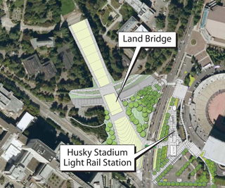
The ST plan is a curved pedestrian bridge from the station across Montlake and Pacific Place, with elevator access at the triangle garage.
The original Vista plan was a pedestrian bridge from the station across Montlake and Pacific Street, with access at the triangle garage via a land bridge to campus.
The modified Vista plan (with no footbridge) seems to cross Montlake at the station at surface level, and connect via a land bridge to campus.
Is this correct?
Yep, you’ve got it right.
Yep!
The original Vista plan is clearly the best, especially if the “optional” footbridge to the hospital is included. Not only does it provide a no-street-crossing access to the hospital from Link at very nearly the minimum possible distance, it gives visual balance from points northwest and higher on the Vista hill.
Your sentence “To me it is more important to grade separate pedestrians from Mountlake and Pacific Ave” is the crux of the issue.
Having downloaded the current Vista PDF from the UW site, I guess that the University at some time in the past year decided that having the bridges connect to the middle of the Triangle is visually unacceptable, since the bridge layout shown in the PDF is the roundabout ST proposal, not the “original Vista” proposal you’ve shown here. Worse, it now seems that ST and the University have decided that there is to be no bridge, presumably because of costs.
Even though the physical distances are shorter with the “current” no-bridge Vista proposal, the traffic and pedestrian access conflicts will be much greater. Remember that with Link east of Montlake (no “u”), the volume of people crossing the Boulevard near the hospital will be at least an order of magnitude greater than any time now except during events at Husky Stadium. And it will happen five days a week, eleven hours a day into the foreseeable future.
Until, that is, the University relents and ST builds exactly those bridges shown in the original Vista plan.
It’s amazing that the University does not understand this. Does the President’s office have a turf war with the College of Architecture and Urban Planning?
First off I don’t know why the footbridge was dropped however I’m pretty sure that it does not interfere with view corridor. The rainier view corridor is pretty narrow and as long as the bridge sets down on the triangle low enough and far enough to the sides it shouldn’t impact the view. Also the topography works really well but the original vista design so the footbridges blend well in with the hill leading up to campus.
As for the president and CAUP I have no idea. I was on the University Transportation Committee last year and it was more of a sounding broad than anything else. I raise my concerns about this then and haven’t really heard much about it until this week. I thought the other bridge was a done deal.
Thanks for the clarifications. This is really an eye-roller of a decision.
This is typically how decisions at UW go. President Emmert is more or less a fundraising figurehead. Several people at different levels in different offices make little choices and you end up with a mess. Just ask me about non-student dining options on campus.
From the fountain, the view is mainly of the hills of the arboretum… here’s a shot:
http://www.flickr.com/photos/hovy/2426101355/
I really don’t understand why you think this is a mess. We’re switching from a design that wouldn’t ever serve the hospital well to a design that serves both hospital and campus pretty well with the option to improve the connection dramatically later for a lot less money.
I didn’t mean this design is a mess, just that the decision process for the UW as a whole is a mess. The design seems decent but less than ideal, but maybe there’s no ideal. The B-G and Pacific Pl overpass is a really big plus.
The ped bridges in the Vista plan seem to have been dropped due to cost, not due to sight concerns. We can build them later with this intermediary plan.
Ben,
Thanks. Costs I can understand; we’re all kind of poor right now.
However there has been a lot of crowing about how the bids on U-Link have been much lower than expected. So it would seem that a shorter bridge directly to the Triangle which would be less costly than the long arc ST had decided upon in order to overpass the Burke-Gilman should be within the budget.
Would someone please remind the planners of that “syllogism” tonight?
In another thread on the subject, someone said that it was these freed up funds that allow ST to go in partially on the Vista concept.
You’re missing a piece.
The short bridge to the triangle requires that the land bridge work is already done – there’s a 16′ increase in triangle height in the land bridge plan.
The original ST ped bridge costs $6.7 million. The land bridge work, which must be done before the new ped bridge can happen, costs $18.7 million. Sound Transit will be contributing the ped bridge money as well as an additional $4 million to the land bridge work (UW and SDOT will split the last $8 million).
It’s possible ST could later come up with the money for the ped bridge, but the land bridge has to happen first to provide the Pacific Pl. and Burke Gilman crossing. The B-G crossing is much more dangerous than a signaled street crossing.
As both a foot and bike user of the area, I definitely agree that presently the Burke-Gilman is more dangerous than the Montlake crosswalk!
Exactly. That’s why the land bridge is a bigger priority – and why the original ST ped bridge went so far onto campus.
This gets us most of the benefit of the ST ped bridge without making the connection bad for the hospital. And later we can relatively cheaply add the ped bridges of the original rainier vista design. The land bridge has to be built before those can go in, it’s not clear from the renders that this is the case, but it is.
Ben,
Thank you for taking the time to make a fully detailed post. And it does make sense to wait because of the elevation changes to come.
If anything is to be dropped due to cost, it would make more sense to drop the grandiose land bridge.
Since we’re talking about ST dollars, build a simple ped bridge across pacific place for now, and let UW bury pacific place from their theoretic stadium rebuild cash.
The original ST plan had two ped bridges. The original vista plan also had two different ped bridges.
Burying a functional surface street, and having zero ped bridges is a huge step backwards.
This plan would still have a ped bridge over Pacific Place and the B-G trail.
The land bridge is necessary to connect the hospital to the station in the future with ped bridges.
P.S.
If the original Vista plan were adopted, the tunnel to the garage I advocated would obviously be completely unnecessary. It was proposed because the ST plan has no reasonable grade-separated access to the hospital.
The new plan helps a lot with hospital access, and in the future we can finish the vista plan. With the original ST design, the land bridge would have been impossible, and direct grade separated access to the hospital would have been impossible.
Grade separated access to the hospital wouldn’t have been impossible, just very circuitous and expensive. The Vista PDF downloadable from here shows an essentially identical arcing bridge to the hospital on the other side of the Triangle.
It would be a pretty long walk, though.
Yes I agree but it would be even longer otherwise. This is by far the best solution. In the future buses that stop in front of the medical center could possibly be routed onto Pacific place and then onto Mountlake, making the transfer much shorter.
By “this” do you mean the illustration in the June, 2008 PDF, the direct bridges in your third link in the original post, or the current at-grade road crossings?
I like the direct bridges better than the June, 2008 ones. That idea isn’t horrible by any means, bit it looks like someone tried to fit the ST design to curve beyond the B-G to the idea of having the bridges land inside the Triangle in order to maximize use of the landbridge.
The more direct bridges might not be a “pretty” from the air, but they’d give essentially equally direct access to campus — actually a few feet shorter, but not enough to matter — but considerably more direct access to the hospital. And they’d be quite a bit cheaper simply from being shorter and not curved.
By the way, for people searching for the illustration to which I’m referring, it’s on page 4, immediately after the Table of Contents.
When you talk about looping “buses that stop in front of the Medical Center” around the Triangle, do you mean the 25, 43, and 48 only or would you also include the east side expresses? That might be a bit of overkill.
There’s no prettiness problem. You seem to have come up with that yourself and then applied it to the UW.
It’s a matter of cost.
The land bridge work in the new vista plan will be affordable, and allow us to build the shorter ped bridges later.
By this I mean the original vista design.
About the looping I’m not entirely sure but the thing is that I have never heard Metro and ST even say anything about it. For example they were looking at having BRT service from UW and they just plopped the stops down next to the existing stops, no concern about the quality of transfer between Link and the buses at all. Its obvious that the plans don’t have much experienced with more developed transit systems where the transfers are actually planed very well.
Ben,
The change between the February, 2008 and June, 2008 plans makes no sense other than as the consultants trying to make the original two bridges look like the arcing ST proposal. Since it costs more to make a longer curved bridge than it does to make a shorter, straight one, I think “prettiness” or the view shed must have been a consideration, at least to someone. Maybe not “UW”, but someone.
Adam demonstrated that the view shed is not a concern, so why else would the designers have changed from short and straight to long and curved other than they or their client thought it more attractive?
The question is, “Why is ST agreeing to participate in a plan that eliminates the grade separations for its riders over the busiest streets in the area and instead subsidizes a visual upgrade for the University?”
Grant, it’s an upgrade we can all applaud and does provide a grade separation over Pacific Place (the street that least needs it…), but first things first for the transit agency: ST needs to fight for its riders’ welfare.
Adam,
Oh, I misunderstood your idea. Beg pardon.
You aren’t talking about routing existing services around the Triangle, but rather the BRT’s to come. Well, they will need somewhere to lay over, and Pacific Place would be a good one for most of the day. It would definitely improve schedule reliability not having them wander down Pacific Avenue, which unfortunately is never going to have bus lanes.
I wonder though if it doesn’t make sense to send them on into the U-District at least during commute hours to avoid forcing transfers. Maybe they could have a little layover at the Triangle stop built in eastbound so that they leave there at a reliable time for transfer from Link.
The reason the skybridge is so long is because they wanted to grade separate riders from the burke gilman trail. The long curved bridge gets over all of the obstacles.
Anandakos, I think you’re confused about the plans. The original Vista plan had the curving pedestrian bridges. The new Vista plan does not due to cost, but is designed so they can be added later.
I answered your question – the burke-gilman crossing is more dangerous to pedestrians than the road crossing, because burke-gilman cyclists don’t have a stoplight.
Aside from that, I think your concerns are because you’re looking at the two designs backwards.
Ben,
There were two renderings of the Vista plan with bridges. The one Adam links to with straight (more or less) bridges and the rendering in the long PDF from the UW with a more curved bridge design.
I think the main difference is one assumes a bridge connection to the station parallel to the tracks while the other has a perpendicular connection.
Chris is right. The “original Vista plan” Adam links to in the headline post is dated February, 2008. It has the straight across bridges to the Link station and the hospital. The curved bridge design in the PDF version is dated June, 2008.
Anyway, it isn’t “danger” that I’m concerned about this time. Danger was the Point Defiance Bypass. It’s pure and simple the enormous hassle of waiting up to three minutes twice a day to cross Montlake for every one of the thousands of people who will be using U-Link during the time between completion of the station and completion of the Montlake overcrossing. Whenever that is. And since it’s not scheduled it could be a long time.
I think it should be scheduled as a part of the Triangle Vista improvement, even if it means ST has to pony up another three million. That should handle the cost for crossing Montlake because the straight across bridge to the Triangle is way less than half as long as the $6.7 million long arc.
I admit that my experience with the Burke-Gilman trail was three decades ago when I worked in the University Retirement and Insurance Office at Brooklyn and the crossing of the B-G. Since I lived in Wallingford I walked it every morning and evening for three years while I worked there and I honestly can’t remember having been hit once.
I’m certain that bike traffic is heavier now, and you’re right, there’s no light at the crossing of the Vista pedestrian way and the trail. But it’s a whole lot less hassle for a pedestrian to slow down or pause for a few seconds for a bicycle or two to pass than to wait for a signaled crossing of Montlake. Yes, very few pedestrians get hit by cars in cross-walks, thanks to the relatively sane drivers in Seattle. And, yes, there are some jerks on bicycles who just blast through pedestrian zones. Still, I think it’s a stretch to say we’re getting “most of the benefits” of the long arc bridge.
There’s nothing to be done about the crossings until the Vista modifications to the Triangle are done. That’s the way it is and you’re absolutely correct about that. But please argue for having the Montlake overcrossing included in the construction of the Triangle improvements so the value of the landbridge is maximized from day one.
What exactly is a land bridge, and how is it different from a foot or pedestrian bridge? Length?
It is just a bridge pretending to be land. Just like a freeway lid. The idea is that it will create a continuous view corridor from the top of rainier vista to the bottom.
Ah, thank you. I’m assuming it will be on pylons, not a berm? Will the surface be actual dirt, or concrete?
I must not be understanding something, b/c the image I have in my head doesn’t make a lot of sense.
Click the link in the post about six or seven up that starts “Grade separated access to the hospital…” and you’ll see that the plan is to cover it with the same plantings as those on either side of it. So the landbridge will be essentially invisible to people in the Vista. For folks on Pacific Place it will look like a freeway lid.
Anc, did you look at the renders that Adam linked to?
Yes, thanks y’all!
Oh. I thought we were planning on connecting to Asia or something.
Walt Disney had a notion of tall structures that could be seen from a distance, that were used to guide people to certain areas around his parks. He called them “weenies.” Cinderella’s Castle is one example. The peak of Space Mountain is another. From far enough away, you can see the structure, it’s interesting, and walking towards it directs you to a new and interesting place that you want to go.
Even if there is not direct line of sight between the UW Link Station, UW Medical, and the UW Campus, proper use of a weenie in the middle of the crosswalk triangle, with localized directional signs and maps at the base, can be used to direct people in the proper direction.
Of course, solving the pedestrians vs. cars problem is another issue.
There will be direct line of sight between the three. Wayfinding should be quite simple – it’s not really a problem now. The hospital’s main sign is within view of where you’ll be coming up from U Link, and several main campus buildings are visible within moments.
sorry to get a little off topic, but i’m curious why the station is next to the stadium and not in the triangle where it would be closer to campus and hospital. was preservation of this rainier vista (which seems very important to the university) the reason?
My understanding is that we can blame physics. The UW didn’t want trains near their physics labs, messing up their measurements. Why they couldn’t just move the physics lab or float the equipment is beyond me…
Ah, it was more than just that. There’s a long comment string here.
That, and because the triangle has a parking garage underneath it.
The original preferred alignment was at 15th Ave NE below Pacific St, which in my opinion is even worse than Husky Stadium because it’s much farther from the hospital and a steeper hill than Rainer Vista. UW owns all the land around both. UW has a poor record on urban form, but I really hope that will change in the future.
I think the alignment was also moved to Montlake Blvd partially because of difficulty tunneling under Portage Bay (near the University Bridge).
Yes, the two stations for the original preferred alignment were located at 15th & Pacific and 15th & 45th. This alignment was discarded due to the risks involved in tunneling under Portage Bay and in building two mined stations (needed due to the crossing depth).
The original Montlake alignment was relocated to the current one due to concerns by the UW of vibrations interfering with research. This required moving the station from Rainier Vista to Husky Stadium. The other station was moved from the Burke Museum parking lot to Brooklyn Ave at the urging of the business community.
If there won’t be any footbridges connecting to the station, it doesn’t need to be built with a second level.
Adam, it would be interesting to me if you were to add an option for an underground pedestrian passage across Montlake to your tables in the post. It seems to me that it would score near the top against most of the other designs for EWD to most destinations. It would have fewer stairs than either of the bridge options for some destinations, and it would have fewer road crossings than the surface level Montlake crossing option. Combined with the underground crossing of Pacific Street, it would provide a weather-protected passage to the medical center.
For those of you concerned about the security in a pedestrian tunnel, you can always get up on the street and walk to the station there.
There’s also plenty of ways to make a pedestrian tunnel feel safer, like having it be wide and have plenty of light, and maybe close it at night when traffic is lighter anyways. Of course, none of these options make it impossible to add a pedestrian tunnel in the future, so hopefully they’ll do that.
You could also add video surveilance and call boxes to a tunnel to increase security. My problem is that if ST can save money by not building a bridge and having a one story station instead of two stories, that money could go into a pedestrian tunnel instead of to the UW. Or to extending the line further north sooner.
AW,
I suggested a tunnel a couple of days ago and most people objected because of safety (and one for “smell”…). You and Alex make good points about how to make it work but it seems like we have a minority opinion, and if they’ll build the Montlake overcrossing promptly, it will be better in any weather except a Pineapple Express. It’s not clear how to make the trip through the garage pleasant and direct. I’m sure it could be done at some cost to the parking capacity.
But the cost of the tunnel would be greater than the cost of the second story of the station. That second story is like the part of an iceberg sticking out of the water, anyway. This sucker is going to be HUGE because of its depth and will sit in an enormous hole bigger than BART’s Montgomery station.
Shaving off the second floor will save only pennies on Grants. Besides, there has to be a mechanical level for the elevators.
It’s great to finally get some attention on this problem.
My understanding is that while ST and the UW are open to pedestrian bridges, the City (SDOT) has a blanket policy against them, and believes people will jaywalk anyway so you might as well provide a crosswalk. I’m not sure I agree, but regardless of that, there’s something else lacking in all these plans.
We need bus stops in front of the UW rail station.
We need a northbound bus stop in front of the station entrance (ideally), or, as another option, bus stops on a traffic island in the center of Montlake Blvd. integrated with the proposed crosswalk. Bus transfers from the south (25, 43, 48), and the Eastside would use this stop to access light rail, a few steps from bus door to to the station. Also anyone coming out of the rail station could board a northbound or westbound bus here to get to the SW campus which is otherwise a bit of a hike from both U District stations. Future bus routes heading straight north would also stop here, providing better access to U Village, 25th Ave., and the Sand Point corridor, which includes Children’s Hospital, which proposes to double in size.
After stopping in front of the station, buses destined for the U District would then access the lowered Pacific Place, either with some kind of a transit-only turn lane, or a grade-separated ramp (which starts as a transit-only right hand lane and then curves west to pass underneath Montlake Blvd., connecting with the widened and lowered Pacific Place proposed in this plan.) This could be funded as part of the SR 520 program which has a legislative mandate to optimize the transit connection at UW for transit service on 520.
We also need a southbound bus stop across the street from the station entrance. This would allow you to exit the rail station and quickly grab a local bus headed south, or east across SR 520 to Bellevue, Kirkland, Redmond.
With the proper treatment of Montlake Blvd., buses could be given a queue jump from that street just as they have a queue jump now on Pacific St. These are pretty straightforward problems to solve.
The addition of East Link across I-90 does not even slightly diminish the need for these bus stops to be close to the UW rail station. East Link targets a different transit market from all of the buses that circulate in the UW triangle area today. There is no advantage to making the walk distance longer than it needs to be. We can come in later and fix this, but it would be better to do it right from the get-go.
People definitely jaywalk across Pacific under the pedestrian bridge near Hitchcock. Personally I think that’s because of the poor access to the bridge (from T-wing you have to go around to get to the stairs, or much farther if you need a ramp).
Johnathan,
These are excellent thoughts; it’s a long way to the bus stops on Pacific Street across from the hospital. The Vista Plan PDF does show new bus stops across from the hospital emergency access, so they’d be closer than the existing first stop at Pacific Place. But not that much closer. So your idea will be much more convenient for arriving passengers wanting to access Link.
However, I’m wondering if you’ve really analyzed the geometry of the bus underpass idea. If you look at the station Site Plan (the first link in the headline post) you can see a faint outline of the station body superimposed on the landscaping. Notice the “Vent” just west of the end of Husky Stadium. If you look at the Wide Cross Section view in the ST Library, that vent is near the north end of the station, but not quite at it. You can see the dashed line maybe fifteen yards north of the “Vent” oval in the cluster of three trees. That’s the north end of the station body.
I think you have a space problem if you try to dive down and to the right of Montlake to make your grade-separated left turn from the right hand lane of northbound Montlake. The downsloping road will really need to “belly-out” to the east a bit under the pink square in order to make the turn at the bottom a decent radius to fit standard buses comfortably. It might fit between the road and the station body, but it will be a really close thing.
If it does miss the station footprint, there’d be no problem clearing the tubes vertically. The top of them is about sixty feet down.
Once the roadway passes under Montlake, how do you propose to connect it to Pacific Place? The roadway surface of the underpass would have to be down at least 22 feet to allow for trolley poles and enough of a roof to support Montlake, and it has to miss the parking garage body under the Triangle, so it can’t join to the east side of Pacific Place. The connection will have to be a rising merge lane in the middle of Pacific Place or on the west side of the street.
Either might work since the street will be depressed for the Triangle Vista improvement, and if the bus tunnel crossed Montlake directly underneath the Pacific Place intersection the depression for the lid and the rise of the bus subway could “meet in the middle” (vertically speaking). However it does mean that the roadway footprint would have to be a lane wider to accommodate the rising bus roadway (actually a little wider than a lane because of the retaining walls).
The current plan under the landbridge shows a somewhat wider than normal two lane road with the support posts directly west of the roadway, between it and the B-G trail. It’s wider than usual because of the bus bays on the east side for most of the distance north of the garage entrance alley. The east side also has a pedestrian path which is necessary to access the bus stops. It seems likely that the rising lane would have to extend at least part way under the lid to make the merge safe.
It’s not going to be easy to squeeze “a widened and lowered Pacific Place” in there. Perhaps if the northbound lane, the bus bays and the eastside walkway were moved east so that he walkway is directly adjacent to the parking garage body it could fit, but that’s the only way.
If it can be made to fit, it’s going to be expensive, but that’s not a reason not to pursue it. The best thing about it is that it gets the buses from the south out of the left turn mess onto Pacific Street. Buses arriving should experience more rapid and reliable access to the U District as well as the Link station through the exclusive bus tunnel.
Unfortunately, the same can’t be said for the buses heading out, because of the fairly involved detour around the Triangle and losing access to the jump lane onto Montlake. It doesn’t look like it’s possible to replace the jump lane by adding one along Montlake because there’s already a dedicated right turn lane along the curb. The buses are going to be stopping in that lane and will have to criss-cross between the bus stops and the Pacific Street intersection with traffic wanting to turn right. The right turners will stay in the right-hand “through” lane until they’re past any bus(es) at the stop, then move into the turn lane. At the same time, buses leaving the stop will want to move left into the Montlake through lane. This is a recipe for lots of fender-benders.
So it seems to me that it might make more sense to keep the departing buses on Pacific Street and add a long stop close to the Montlake intersection, east of the hospital emergency entrance. The buses often have to stop there anyway because of the back up from the light at Montlake.
Then build a diagonal pedestrian tunnel from the southwest corner of the mezzanine level under the Pacific/Montlake intersection to the bus stop and beyond to the basement of the Med Center building if acceptable to the University. That’s not cheap either and would “compete” with the proposed bridge from the raised Triangle to the Med Center. The bridge would be a longer walk from the bus stops but would serve more needs, since it would connect to the campus through the landbridge.
A tunnel to the bus stop would be similar to one of the entrances to the Civic Center BART station which runs nearly a block under Market to the west in order to underpass Hyde and give a “no-major street crossing” access to the Civic Center Plaza.
Doing the incoming buses with the “island” stop would be operationally questionable. Assuming the placement of the cross-walk as shown in the “revised Vista” plan, there will be room for only one articulated bus at the island platform if it’s south of the cross-walk. That might cause traffic jams by a following bus waiting for the platform.
If it’s north of the cross-walk there are no size constraints and you can have a waiting queue holding an artic or a couple of standard buses south of the cross walk. But you’ll have people fidgeting on buses stopped in that holding queue, wanting to use the light cycle for which they’re stopped to get to the Link train. The “walking man” won’t come on very often with all the traffic on Montlake; you can be assured that WADOT will make sure that the cars get priority.
This really is quite an awkward location for the station considering the bus interface. There are no really “good” solutions because the buses don’t have their own access to the station.
What an excellent, detailed response.
From a transit planning perspective this station would have been better placed under Rainier Vista between Stevens Way and Pacific Place, which is where Sound Transit wanted to put it once the decision was made to cross under Montlake, but the UW put the kibosh on that plan. That location had the best bus transfer story and better served the central campus. It would have fit perfectly there. But, sadly, there were other issues.
At least we can have a good interface with the buses that run today on Pacific St., with a bit of effort. It doesn’t appear that effort has been made by anyone up to now, despite official policies at the city and state levels that prioritize a direct transit connection here. The key is figuring out how to get the buses through there with a minimum of delay for through-trips while still providing bus stops in front of the station, at least northbound. That leads to interest in a transit-only grade-separated connection from northbound Montlake to westbound Pacific Place.
When you look at the sum of all the transit-related investments we are making in the region (ST, HOV lanes on 520, etc.) and consider the importance of this transit hub at the confluence of major transit services, the amount of money it would take to fix this particular problem is miniscule by comparison. I’d like to see the various agencies, institutions and jurisdictions here work together to find a way to make it work. It’s a fairly self-contained integrated design problem.
I have not actually laid out a grade-separated transit-only lane under Montlake connecting to Pacific Place, but there’s a fair amount of room to work with west of the station box and north and east of the actual triangle parking garage underground structure, which is a lot smaller than the triangle on the surface. I think it can be spared completely even though it does not deserve to be treated as some kind of sacred site of great cultural significance — it’s a parking garage.
The elevation of the Montlake/Pacific Place intersection should not be held as sacred either. If this had to be raised a few feet in the process of building a transit lane underneath, I don’t think it would harm that area. That intersection is out of the view corridor for Rainier Vista. A slightly raised ped crosswalk at Pacific could easily be matched on the triangle side in conjunction with the rest of the Rainier Vista plan. It wouldn’t be raised more than a few feet, and then only if it helps get the buses to Pacific Place. That may or may not help; it needs to be laid out.
In the other direction (southbound), the right turn volume from southbound Montlake Blvd. to westbound Pacific St. (not Pacific Place) is very low-volume. This is fed by the existing lane on Montlake Blvd. north of Pacific St. adjacent to the triangle. Buses already use this lane (e.g. 44) to turn back west. We could simply carry this lane through the intersection and connect it to the existing transit merge lane on Montlake Blvd. just north of the bridge, which is the same place buses already go from the existing eastbound Pacific St. HOV lane. The southbound through-movement would be transit-only.
The route around the north end of the triangle is about an eighth of a mile longer than just going up Pacific Street (the current routing.) It would involve an additional stop for buses, yes, but they already stop for drawbridge openings that take six minutes. The extra dwell time and distance might add a minute or so to travel times for through trips, but would save maybe four minutes of walk time and one major street crossing in each direction of a commute for the approximately 25% of the users of this station who are transferring to or from buses.
At yesterday’s ST meeting, the facilities planning officer from the UW told me that all the buses were full in that stretch, as if that would be a reason not to make this connection efficient. If buses are full, then we need to add some more buses, not make it less convenient. If masses of people have yet to clamor for a better bus-rail transfer here, maybe it’s because ST has yet to start excavating the hole for the station. Most people aren’t following the planning process as closely as we are. Once people make this walk a few hundred times in the rain across two busy streets, I think they’ll have formed an opinion on this connection.
It seems like it would be possible to reconfigure the area between the east side of the station and Husky Stadium to accommodate a bus transfer area for northbound buses. The buses could enter near the existing entrance to the Husky Stadium parking lot and exit at the existing intersection of Montlake and Pacific Place. This would keep stopped buses from blocking northbound traffic on Montlake and allow U-District bound buses to use Pacific Place to get back to Pacific.
Re Update #2,
The straight across bridges would serve nearly all trips optimally except those to the southbound bus stop on Montlake. From the Vista PDF diagram it looks like the “ADA Accessible Path” running off the picture toward the corner of Montlake and Pacific Place should have a branch back toward the elevator. Most people would prefer to walk an extra twenty yards than wait for a hydraulic elevator. I know I would.