Seattle’s growth is still accelerating. Census estimates released yesterday show almost 21 thousand new residents in Seattle in the year ended July 2016. With 704 thousand residents, Seattle is once again the nation’s fastest growing city with 3.1% annual growth.
We’ve become accustomed to fast growth, averaging 15 thousand new residents in Seattle annually between 2010 and 2015. So it’s impressive how Seattle has stepped up its game to add even more residents. As Gene Balk observed yesterday, Seattle is only the second top 50 city to grow more than 3% in one year this decade (the other was Austin in 2012). 3% growth in a mature city is a big deal.
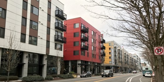
Demand for urban living is strong, as evidenced by high prices for homes in walkable neighborhoods all over the US. But most cities have a hard time delivering those homes. Curbs on urban growth push many involuntarily to the suburbs, and most metropolitan areas are still becoming more suburban. More so than any large American metropolitan area, Seattle has densified as it has grown.
Seattle accounted for a massive 58% of all King County growth in 2016. Seattle’s acceleration was matched by a slowing of growth in many King County suburban cities. Total growth in King County in 2016 was about the same as 2015. A few cities on the central Eastside performed well. Bellevue (+1.3%), Redmond (+3.2%), and Issaquah (+3.6%) all showed healthy growth rates. But the rest of King County had its weakest growth since the recession, and expanded just 0.8%.

Taken together with the county-level migration patterns we reported in March, we see two diverging trends. Seattle and a few progressive cities on the Eastside are expanding housing to match the employment boom. At the same time, other King County suburbs are slowing housing growth, fueling an accelerated migration to more distant suburbs in Snohomish and Pierce Counties.

The largest cities in Snohomish and Pierce Counties had a good year. Lynnwood added 1,200 residents (+3.1%), more than in the preceding five years together, boosted by development near Alderwood. Everett added 1,800 (+1.7%). Tacoma added 3,600 (+1.7%). Everett and Lynnwood outpaced the Snohomish County average, but Tacoma has persistently lagged exurban Pierce County.
While not large in absolute terms, some exurban cities are growing strongly. Marysville and Puyallup were among those adding more than one thousand residents in 2016.
The centralization of growth in Seattle in 2016 was remarkable. For most of this decade, Seattle’s share of King County population growth hovered around 40%. The lopsided urban expansion (58% in Seattle) reflects both the city’s success in expanding housing supply, and failure in many King County suburbs to accommodate housing demand. We should celebrate 21 thousand new Seattleites, but not be distracted from the growing housing shortage countywide.
I think percentage growth is a bit misleading. It tends to make smaller areas look they are growing faster than bigger ones. Given that, it is even more impressive that Seattle is one of the leading cities in terms of percentage growth.
I would like to see some of the charts showing absolute growth. Places like Issaquah and Lynnwood growing at 3% sounds impressive (like they are nipping at the heels of Seattle) but are nothing compared to what Seattle is experiencing. Issaquah has grown 22% since 2010, but since there were only 30,000 people then, they have added less than 7,000 people. Seattle adds that many people in about four months.
In general what I see happening is that Seattle is adding a lot of new apartments. While some of that is going on in other cities, not nearly as much. The other parts of the region are generally growing by sprawling — adding new houses on empty land. Growth like that is huge from a percentage standpoint (for the particular region) but not as significant from an absolute standpoint. The 58% number bears that out.
I would assume that this is very unusual. It is one thing for a town or city to grow by sprawling. But it is another thing for a mature city to grow so fast.
I made a chart of Population increase vs land area, it’s a little better than just raw population increase since it accounts for the fact that Seattle is physically larger than most of the surrounding cities.
http://imgur.com/a/N2yB4
Seattle has the most growth by far, but Issaquah is still in second, which just shows how much Issaquah has been growing recently.
Notice who brings up the rear of the population growth/square mile chart? Lakewood, home of [ot] O’Ban voters.
Jes’ sayin’.
Good chart, Colin. Thanks.
From that chart the trend looks a lot more straightforward. Seattle is booming, and no one is even close. The east side is also growing very rapidly — faster than the northern or southern suburbs (or cities). The biggest outlier is Marysville, which has outpaced every other Snohomish County area. I wonder why. Everett doesn’t seem to be growing very fast, and business in Everett doesn’t seem to doing that well. I would imagine there are folks that commute all the way to Seattle, but that doesn’t seem like enough to explain it. Maybe it is just a case of having way more land available for homes than Everett.
Agreed, good chart.
Kirkland, Sammamish, and Issaquah all annexed unincorporated land in 2010-2016, so that explains a chunk of their growth, though for Sammamish & Issaquah the annexations were generally greenfield development so it’s still net growth for the region. My best guess on Marysville is annexation plays a role, or at least large greenfield development.
The numbers I used, and I think Colin’s too, are adjusted for annexation. The Census uses updated shapefiles to reestimate prior year’s population within current boundaries.
For instance this.. https://twitter.com/danjryan/status/867597308963151872
The Kirkland annexation was 2012, but the estimates for each year are within current boundaries, while the April 2010 count alone is within the then boundary.
“The biggest outlier is Marysville, which has outpaced every other Snohomish County area. I wonder why. Everett doesn’t seem to be growing very fast, and business in Everett doesn’t seem to doing that well. I would imagine there are folks that commute all the way to Seattle, but that doesn’t seem like enough to explain it. Maybe it is just a case of having way more land available for homes than Everett.”
Word from north Snoho is that’s it: they’re slashing farmland to build single-family sprawl inside the urban-growth boundary. Because everybody wants a detached house with yard and nobody wants to tear down their existing houses to make room for more. Greenfield Marysvillites, meet NIMBY Everettites. This is the same Everett that opposed Link on 99 and threatened to sue ST if it did so because it thinks 99 is perfect and dense enough and we need that many car dealerships. (How can they all stay in business anyway?) Everett wants a cool downtown, but that should be seen in the context of several previous attempts to revitalize downtown Everett that all failed, although the last one did have some minor success. I see a whole lot of houses and one-story businesses around Broadway that could easily be upzoned. But Marysville is the flashy new thing, and people want flashy new things. That’s why malls killed Main Street and now new malls are killing old malls. So the leapfrog to Marysville is similar as the leapfrog over King County to Snohomish and Pierce Counties.
Lynnwood will save us. It’s sure to become the largest urban center in Snohomish County, and it’s centrally located and will have double-frequency Link and 405 BRT. There’s already a lot of apartments on 200th between downtown Lynnwood and the college. The biggest question will be, will it allow the periphery to grow around the new downtown, for those who can’t afford to live in a highrise.
Political units are fairly arbitrary. You could chop Seattle into 10 cities and argue that none of them individually matter. But collectively, there’s an urbanizing core which includes a lot of Seattle and Bellevue and Redmond. Arguably Issaquah, but there’s a more complex story about development patterns there. The Highlands aren’t urban, but maybe the new developments on the valley floor are.
If this were just a story about high growth in Seattle and a few nearby suburbs, and lower growth in other suburbs, it would be a clear good news story.
What makes low suburban growth concerning are the increasing number of people driving through low-growth King County suburbs to get to higher growth Snoco and Pierce suburbs. Places like Kirkland, Renton, Bothell all posting weak 2016 numbers in the face of obvious housing demand and pass-through traffic.
I wonder (hope?) if some of the pro-growth politicians in Shoreline can use the city’s declining population to make the case for the urgency of serious upzones.
Shoreline’s population can’t be declining. If it were you’d see a rising vacancy rate and falling home prices, and would-be Seattlites would be flocking to it to avoid moving further out. My friend who lived in Shoreline said taxes are high because people want the highest school quality, and that attracts education-minded parents. So Shoreline is sitting pretty as far as I can tell. It will get growth in 5-10 years with the upzones, and that will fill up immediately due to Shoreline’s schools, close-in location, double-frequency Link, and intact street grid.
Places like Kirkland, Renton, and Bothell won’t have light rail anytime soon if ever. I don’t fault them for accomdating less growth than those that will. Shorline however could do a lot more IMO.
@Mike — Shoreline’s population could be shrinking without any vacancies. Smaller families is the short answer. As small houses disappear and grow more expensive in Seattle, people are pushed out to areas like Shoreline. So they buy bigger houses, and just find things to do with the extra space (computer room, man cave, etc.). You also have people living longer, which means empty nesters don’t turn their house over to the next generation as quickly.
That doesn’t mean that Shoreline isn’t adding new units. They obviously are. It is just that the two largely balance each other out.
In general this is where the growth should come from. Not just Shoreline, but similar areas in Seattle. There are lots of places with really big lots. In most cases you could easily add another house on the lot. If the house is big (and there are some big ones) you could split it up into apartments. ADUs — we need more ADUs in those areas. Places like Shoreline (and Magnolia, Pinehurst and Wedgewood) could have way more people per house than they do now — maybe even more than when people had lots of kids. All it would take is a change in the rules.
It can even be couples moving there before they have children, buying houses with extra bedrooms for a planned family that hasn’t arrived yet. Given the Shoreline schools, i can certainly see couples moving into a three bedroom house pre-need.
Issaquah has strong growth in because of annexations and greenfield development, in particular the Highlands and Taulus communities. Issaquah will likely continue to have strong growth, but the type of growth will transition from greenfield to infill in Central Issaquah.
The Bellevue-Redmond development is occurring along an axis that is basically the East Link alignment. Issaquah, OTOH, is development along the I90 corridor that includes large planned communities in Snoqualmie.
For the rest of King, it’s still 6% growth in 10 years, which isn’t shabby. I think the big opportunities for growth are Shoreline and Kent around future Link stations, and the 522 BRT corridor. The lack of growth in Shoreline really seems like more of a timing thing than anything else.
Ah, annexation certainly complicates things. It can make cities appear to be booming when all they did was change the borders.
As Ryan notes, population growth in some surrounding cities is flat. That’s ok in the abstract, but we are building light rail to some (Shoreline) in ST2 and several others in ST3.
Some surrounding cities are expected to add density but it isn’t yet enough to show significant population growth. Is there another structural cause in the market (like a desire to live in hip urban neighborhoods), NIMBY pressures or just non-visionary staff and boards?
Shoreline, as I said below, has impressive zoning around its RapidRide stations and Link stations. Its 2016 growth was negligible probably because zoning was in flux and everybody was waiting for it to finish. It has now finished the zoning around Link stations and 145th, so growth should catch up in the next 5-10 years.
Shoreline was minus 30 people in 2016 (though that’s probably within the margin of error on these estimates). But it makes sense if multifamily development was on hold pending regulatory action. Lots of mature single family areas losing population as empty-nesters outrun densification of established neighborhoods.
30 people is equivalent to two blocks of houses being held vacant for a couple years until zoning solidifies.
If people are actually moving out of Shoreline houses then… there’s fewer people to complain about converting them to apartments and townhouses, right? So was that opposition about upzoning the station areas weak because people were moving out of the area anyway? That may have been a factor to help the city council stand firm in the upzones.
Dan, three and a half years ago, Seattle’s spectacular densitizing threw me and dozens of my neighbors out of our small apartments a hundred feet from the Route 44 trolleywire. 20 days notice to vacate more than 20 years of Seattle’s densest and most Transit Oriented residence. Hope they call the Ballard LINK station something else.
Relocation wasn’t my choice. But saw to it new address gave me reliable transit literally from my door to Downtown Seattle. Faster and more fuel efficient ride than any King County address I could afford. Especially in Seattle.
Three years later, results of Seattle’s spectacular densitality add at least a hundred motoring miles to my every round trip parallel to I-5. One seventy to Angle Lake for closest reliable transit anyplace north. Tacoma Dome being trafficked in as well.
Not putting a tire on a “freeway” subject to instant lockdown makes three scenic hours bearable and fuel efficient. But tempting for Steilacoom, Yelm, and Belfair to do checkpoints after three AM.
Shouldn’t be a “like it or not” that Seattle is part of same region as Vancouver BC and Portland. Which when the United States rejoins the advanced industrial world, will leave feuding subareas to Europe.
Making it worth their own while for the beneficiaries of Seattle’s current prosperity to carry their share of the costs of the regional membership from which they’ll probably gain the most benefits. Mature cities do that, don’t they, Ross?
Mark
Claudia Balducci keeps saying the Eastside’s population is almost equal to Seattle’s now. In the Eastside Transportation Forum video article I wrote, “1:25:51. Seattle in 2035 will have 720,000 residents and 664,000 jobs. Eastside cities in 2040 will have almost 700,000 residents and more than 550,000 jobs. Traffic across Lake Washington is nearly the same in both directions.”
So how true is that? How fair is the comparison? How does it relate to the apparently contradictory data above? Should we rethink our attitude toward the Eastside, and if so how?
One discrepency is that if she’s using the commonly-understood meaning of “Eastside”, Bothell to Renton, that’s a larger north-south area than Seattle. The comparable west side would include Shoreline, Skyway, Burien, and at least part of Tukwila. So the Eastside numbers are being “helped” by a quarter or third more area. If we accept that as a kind of golf handicap (i.e., unequal deemed as equal), then what?
It’s intuitively hard to believe the Eastside has as many people as Seattle since there’s no equivalent to Center City, the U-District, or Ball-emont-ingford. So how can its population be so high? Are the apartment units in Bellevue, Redmond, and Issaquah really as numerous as that? Apparently so, if the population is not in the other cities, which have much less density and are decelerating.
As for sprawl, I’m pretty sure Bellevue is not building any more single-family houses since the last empty land was built up in the 90s (Richards Road and Allen Road areas). Instead there’s lots of new apartments and townhouses downtown, on NE 8th Street, 145th Place SE (northwest of Bellevue College), and Overlake and the Spring District are next. Spring District apartments are already under construction. Maybe Crossroads and Factoria will follow eventually.
Redmond I don’t know much about, although it supposedly has the highest average density in the region (even over Seattle) and is the fastest growing. I see the apartments downtown but the cluster doesn’t look that big, yet maybe there’s more going on that’s harder to see from the 554, B, 224, adn 232. Or maybe I’m underestimating the population of Redmond Ridge.
Issaquah since the 90s has been a story of lots of two-story apartments, close-together houses, and new urbanism. I was shocked when I saw tons of apartments in central Issaquah, row after row of them.It’s not something you expect twenty miles out. And we’ve written a lot about the Issaquah Highlands, probably the best example of new urbanism in the region, with a mixture of close-together houses and apartments, much of it within walking distance of the P&R and less than a mile from a shopping district; if only it weren’t so isolated. The only parts of Issaquah I’ve seen are those visible from the 554 and 208 and the old town. There may be something happening in the northwest along the 200. Still I’m impressed with the apartments and close-together houses: it’s a great step for a no-longer-exurb. And it has been enthusiastic about Link and upzoning an urban center for Link.
There’s one glaring discrepency in all this. Kirkland has upzoned Totem Lake in an effort to keep growth in the periphery along 405 where nobody wants to live (or at least existing Kirklanders don’t). Totem Lake is getting 405 BRT and the promise of at least thinking about future Link. But Kirkland has the smallest growth on the chart re Eastside cities. So it needs to step up. On the other hand, maybe it’s just in a lull until Totem Lake opens. That seems to be the case in Shoreline, which has no growth in 2016 but that’s probably because its zoning has been in flux and it just finished upzoning around the Link stations and 145th, so it should catch up in a few years.
Other thoughts on the Eastside’s relative population, density, and what attitude we should take toward it? The central core (Bellevue-Redmond axis) certainly seems to be becoming an extension of Seattle, even if there’s nothing as highly walkable as Summit or the U-District.
(I don’t understand why the Eastside doesn’t simply build a neighborhood like Summit/Broadway/Pine since there’s certainly high demand for it. There’s enough demand for three or four of them. And then fewer people would commute from Seattle.)
Those are clearly old estimates as Seattle probably has 720,000 people right now. The numbers just released (704k) are estimates as of last July, and Seattle added 21k people in the preceding year. So by May of this year Seattle almost certainly has 720k total population, given there is no evidence of a residential slowdown. By July Seattle is likely to have about 725,000 people. 18 years ahead of that estimate.
I thought that Capitol Hill activity example is kind of the goal for the Spring District and Downtown Redmond. Am I wrong?
The Factoria-to-Eastgate area also has the bones to be a more intense urban center as well — except for the effects of that wide, noisy river called I-90 running through it.
No you’re right – the Bel-Red corridor is the big piece that Mike is missing. Redmond’s growth is much more that just their downtown (though the downtown is definitely growing). In Overlake (i.e. Microsoft) there are dozen 4-6 story apartment buildings in the pipeline.
“I thought that Capitol Hill activity example is kind of the goal for the Spring District and Downtown Redmond.”
That would be wonderful if so. I’m not confident they understand how to make a Capitol Hill. It’s not just density. You also need small blocks, small buildings, narrow vertical buildings, narrow storefronts, minimum parking garages, and no excessive open spaces. This makes it pedestrian-friendly. If you walk down Broadway or the Summit residential streets any hour day or night you’ll see other people walking home, walking to the store, walking their dog, etc. That’s what you don’t see in downtown Bellevue. Yes, there are pedestrians, but not enough to feel like you’re in a pedestrian neighborhood. Everything needs to scale down, both the buildings and the parks. Boston, Paris, and Summit are dense but downscaled and lowrise. That’s what suburban neighborhood centers need to do.
I know that it is arbitrary, but I think of the Eastside as being Bellevue, Newcastle, Issaquah, Sammamish, Redmond and Kirkland. Renton is south-end and Bothell is north-end.
Issaquah may be almost 20 miles out from Seattle, but it has good freeway access and the core is only 12 miles from Bellevue. Additionally, I-90 east of I-405 flows considerably better at rush hour than I-90 across the bridge or I-405. Put those together and Issaquah is a great location for commuting (by car) to a lot of good jobs. Not exactly what a transit advocate would be celebrating, but something that would be embraced by a lot of people. Peak transit access to Seattle is good, but access to Bellevue (271,555,556) is lukewarm at best.
Now add that to all of the flat land that is ripe for redevelopment and a pro-density Issaquah city council and you have a recipe for quick growth.
“RCW 81.104.040
Policy development in central Puget Sound—Voter approval.
Transit agencies in each county with a population of one million or more, and in each county with a population of from two hundred ten thousand to less than one million bordering a county with a population of one million or more that are authorized on January 1, 1991, to provide high capacity transportation planning and operating services must establish through interlocal agreements a joint regional policy committee with proportional representation based upon the population distribution within each agency’s designated service area, as determined by the parties to the agreement.
(1) The membership of the joint regional policy committee shall consist of locally elected officials who serve on the legislative authority of the existing transit systems and a representative from the department of transportation. Nonvoting membership for elected officials from adjoining counties may be allowed at the committee’s discretion.
(2) The joint regional policy committee shall be responsible for the preparation and adoption of a regional high capacity transportation implementation program, which shall include the system plan, project plans, and a financing plan. This program shall be in conformance with the regional transportation planning organization’s regional transportation plan and consistent with RCW 81.104.080.
(3) The joint regional policy committee shall present an adopted high capacity transportation system plan and financing plan to the boards of directors of the transit agencies within the service area or to the regional transit authority, if such authority has been formed. The authority shall proceed as prescribed in RCW 81.112.030.
[ 1992 c 101 § 21; 1991 c 318 § 4; 1990 c 43 § 25.]”
Whatever the limitations of the Washington State Legislature, notice the number of times they used the word “regional” when they conceived what became Sound Transit. And Claudia Balducci chairs the County Council’s REGIONAL Transit Committee.
Our land use and transit planning this afternoon are in same condition as the European continent. Europe’s only hope for dealing with the very large problem of survival, let alone functioning, is to start thinking of all its component states as part of a single country.
Interim, it would make huge sense for us to divide transit into corridors, instead of subareas, whose multiple divisions every corridor must cross. I-5 between Everett and Centralia is an excellent example. No satellite can see the city and county lines through the car roofs, hoods, and trunks. Let alone subarea boundaries.
But even though in 1992 the State Legislature capitalized “Region” with a goose-feather in long-hand, and made every final “S” look like an “F”, RCW 81.104.040
left a rare example of, like somebody else put it in inky longhand, Common Sense.
What its neighborhoods, cities, subareas, counties, and State can’t handle politically, like land use planning and public transportation…worth giving the Central Puget Sound Region its turn.
Mark
I suppose it depends on how you define “Eastside”, but I find the idea that the Eastside will be similar in population to Seattle to be absurd. Here are some numbers, rounded to the nearest 5,000, as of 2014:
Bellevue — 140,000
Issaquah — 35,000
Kirkland — 85,000
Sammamish — 50,000
Mercer Island — 25,000
New Castle — 10,000
Redmond — 60,000
Renton — 100,000
Bothell — 35,000
Seattle 670,000
So Eastside as Andy and I would define it is about 400,000. Even if you toss in Renton and Bothell, Seattle is bigger, by over 100,000. So the only way that the East Side would be bigger in a few years is if it is growing faster. But it isn’t. Quite the opposite. Holy cow, Seattle — just Seattle — accounts for over 58% of the growth. At best those East Side cities are only 42%, but other parts of King County are growing (including places like SeaTac, Burien and unincorporated areas). So the East Side is growing way slower than Seattle, and would have to grow way faster — I mean really, really fast — to catch up. Unless, of course, you use a very loose definition of “East Side”, like calling Kent the East Side.
“Political units are fairly arbitrary.”
I meant to mention that. The above numbers imply Seattle’s growth is even throughout but it certainly isn’t. Only urban villages are getting growth, and they’re a quarter of the residential land. Suburban cities are the size of Seattle’s districts, so their true character is more transparent. Bellevue is visibly different from Newport Hills and Renton in the stats, while the contrast between the Admiral District, downtown, and Lake City are invisible
From our own knowledge of Seattle, we can say that its urban villages are growing fast like Redmond, while its single-family areas are hardly growing at all like Newport Hills.
Dexter needs a Link stop. What, Link under Dexter? Yes, if there ever is an ST4 there should be a branch which diverges from the Green Line between Gates Foundation and Lower Queen Anne. To accommodate this branch, the Gates Foundation station should be “stacked” like the 1-2-3 line subway stations on Park Avenue West.
The Dexter stop would be “on the way” to Lower Fremont where the line would do one of two things, depending what happens to the Green Line beyond 17th (I hope) and Market. If it turns east to build “Ballard-UW” — and serves as a one-transfer intercept for Greenwood/Green Lake bus lines — then the branch line (“Yellow”?) would continue north from central Fremont. It would travel Fremont up to around 45th/46th then under the park to join Phinney/Greenwood about 58th with three stops between Fremont and “downtown” Greenwood: 45th/46th and Fremont, 62nd and Phinney and 72nd and Greenwood. The blocks on either side of Phinney/Greenwood north of the zoo would be upzoned for 30-stories at the station nodes producing hundreds of new, high-quality “view” properties with little impact on the neighborhoods on either side of the ridge. The buildings should be “checkerboarded” like in Vancouver BC to preserve sight lines for their occupants and reduce shadow effects on the hillsides.
From downtown Greenwood it would continue north under Greenwood with another station about 96th and then turn east to enter the Interurban ROW on which it could run “at-grade” in reserved right of way. There are few streets which cross it south of 145th; they could have under-passes or over-passes if it is desired to protect the line from vagrant automobiles.
It would make sense to terminate it at the old Sears development at 160th and high-rise the heck out of it. It’s surrounded by commercial activities, so shadows are a non-issue.
On the other hand, if the Green Line continues north on 15th NW eventually to serve the area north of Woodland Park, the Yellow line would turn east through lower Wallingford with a station somewhere around 37th and Wallingford for a node there, one in the southwest U-District (8th and 42nd?), a cross-station at 43rd and Brooklyn, one in northeast campus for the dorms there and then on north via a TBD route to Lake City.
The station at Fremont would lie on a southwest-northeast axis and be stacked so that a spur could branch to the west just beyond the platforms to create Ballard-Fremont-UW-Kirkland-Redmond.
Dexter needs a Link stop.
When we get 45th and Lake City squared away, and a Metro 8 line is either adopted or rejected, then the next priority will probably be an Aurora line. That could diverge to Dexter and Greenwood possibly. If the pessimists are right that Central Link in north Seattle will become full by 2040 or 2050, then an Aurora relief line will become more urgent.
And the redevelopment opportunities are enormous. Linear or not, you could fit a lot of TOD along Aurora. That alone should raise the priority level for such a line.
I’d rather have “real” BRT along Aurora, as that would allow much closer stop spacing in Seattle than a light rail line. Leave Link as the “express” route for riders coming from Snohomish into Seattle.
We can certainly invest more into Aurora, but I actually think a rail station with 1/2 mile station placement is inferior to center-running BRT with 1/4 mile station placement.
The extra expense of a rail line vs. BRT is better spent elsewhere in the system, in particular east-west subways like Ballard-UW and/or Metro-8. Aurora’s wide ROW is well suited for BRT.
If we don’t build an Aurora line, what will we do instead if Central Link approaches capacity? We’ll have to start something ten years before it gets overcrowded, otherwise we’ll be back to the situation we are now.
If you read carefully you saw that I advocated that this either go to the U District and “then on north via a TBD route to Lake City” and include the spur to Ballard to create Ballard-Fremont-UW (IOW “45th”). If the Green Line turned across 45th it would provide “45th” and the “Yellow” line would head on north.
Either way, Ballard-UW would be handled. If by the Green Line it’s probably not possible to have the Tacoma trains continue on to Lake City, but an “overlay” service that turned back at an appropriate destination in the near south end could use the route.
All I’m saying is that, as Lazarus noted, Aurora/Dexter south of the bridge is a great place for ultra high-density. There’s nobody to the west to have their view or sun blocked because the top of the hill is a hundred feet higher than Aurora and 150 than Dexter. The extra shadowing to the east from high rises there is trivial because east of the plateau on which Dexter runs is nothing but commercial development on Westlake.
North of the Aurora Bridge, however, Aurora is a lousy transitway. It is completely neutered for a half mile by Woodland Park and half neutered by Green Lake for another half-mile. The same thing happens north of 110th; there are cemeteries on both sides to 125th and then the stroad is surrounded by big boxes. It’s two blocks either way to actual housing. A subway under Fremont/Phinney/Greenwood is much better placed to take advantage of the elevated topography and provide a decent walkshed around the stations.
Interestingly, having a subway placed along the crest of a long fairly narrow hill like Phinney Ridge actually makes access from the sides easier than from the street level. The Second Avenue entrance to University Street under Benaroya Hall is an excellent example. But on Phinney Ridge the “walk straight into the Mezzanine” effect would be to both the east and the west.
So far as the Metro 8, I don’t see how that will ever qualify as “regional transit”. It’s a City of Seattle responsibility. The only reason Ballard and West Seattle were included and got support from the suburbs is that they are planned for extension north to Shoreline and south to Burien.
Sure, have Sound Transit build a Metro8 — they have a great engineering department — and run it of course, but if it ever happens it will be built with City funds.
Mike,
Thanks. I don’t think there’s any possibility that rail can cross the Aurora Bridge. So though the line may seek Aurora somewhere north of Evergreen-Washelli, depending how far it goes, it makes sense to have it in the Phinney/Greenwood corridor where there is already a significant degree of density and room for much more.
@- Mike, I guess I don’t think capacity will be an issue. I think the system can run 4-car trains at sub-3 minute headways, and I think even at our current growth rate that’s adequate for the next 30~50 years. We won’t need a whole extra line unless we take out I5
@Richard – I agree, any “Aurora” line wouldn’t actually follow 99 directly but would likely wander to Greenwood for a few stops north of Fremont before coming back to Aurora.
But I think it’s difficult for a single rail line to serve Aurora, Dexter, and Westlake at the same time given the geography in the corridor between Mercer Ave and Fremont. I actually prefer having 3 separate high frequency bus routes to provide better coverage. Truncating these routes at Fremont might be good for a rider coming from Phinney Ridge but it cuts services for Westlake, so I don’t think it’s a net gain for the city.
@AJ,
You might prefer such a “real” BRT solution, but there is exactly zero evidence that such a scheme would do anything more than what RapidRide E has done to date. The stop spacing is roughly what you propose, the features are roughly what you propose, the frequency is roughly what you propose, and yet what has it done per redevelopment and increased housing in Seattle? Statistically nothing.
Seattle needs to stop looking for magical bullets that involve little to no spending yet solve all the world’s problems. Such magical thinking is what gave us the 5 votes on the monorail. It is the same thinking that gave us a large bus system that has been limping along for decades.
Na, if you want to increase housing in Seattle by providing fast, efficient, and convenient transit, then skip the half-step of faux BRT (which is all this region would be willing to pay for a bus based system) and just make the investment that is required.
Real investments bring real rewards. Half steps do not, no matter how well intentioned.
“So far as the Metro 8, I don’t see how that will ever qualify as “regional transit”. It’s a City of Seattle responsibility. The only reason Ballard and West Seattle were included and got support from the suburbs is that they are planned for extension north to Shoreline and south to Burien.”
No, they’re regional. The spine-centric view is that Sound Transit’s mandate is to build the spine first, not to build the spine only. When people travel from Bellevue or Burien to Ballard, that’s a regional trip. If a significant number of people do it, then it should be on the regional transit network. People go to Ballard for the Locks, for their favorite music bands, for the old-fashioned town center, for work, for the large farmers’ market, etc. I know people who go from the Eastside to Fremont for users groups and medical-social events. All of that justifies regional transit to those places, at minimum to decrease the amount of driving. West Seattle is the same way. People go to West Seattle to go to Alki, the ferry, Lincoln Park, the Junction Village, and to visit people and attend events.
The fact that Ballard and West Seattle aren’t along the highest-volume downtown-Capitol Hill-UW-Northgate axis doesn’t mean they aren’t regional centers. Ballard-Fremont is “almost” a PSRC regional growth center, and this an automatic candidate for high-capacity transit. The reason it isn’t is that King County’s formula focuses on jobs: an area has to have a minimum amount of zoned job capacity to become an RGC. Ballard-Fremont has more of a housing-jobs balance: it has more housing capacity than required but not enough job capacity, and housing capacity doesn’t count in King County’s formula. Which means that either the formula needs to be revised, or that Ballard-Fremont and Lake City should be granted exceptions. If they were official regional growth centers, then there would be no question about extending Link to them, and it would also have affected the decisions in ST1 and ST2.
@Lazarus, the E-line is the highest preforming line in the city! I wouldn’t call that nothing. Moving from BAT lanes to center running lanes would improve speed, reliability, and frequency along the line, and would do a better job connecting communities than a rail line that’s optimized to just get people to downtown quickly. There are plenty of examples of good BRT internationally. To date, this region hasn’t had the political focus to implement true BRT, but I think we are getting closer and Aurora is an appropriate corridor to invest beyond RR+ into true BRT.
And I don’t get your comments around housing. Light rail doesn’t create housing, upzones create housing.
@Mike – wholeheartedly agree. Any expansion of the Link system is a benefit to everywhere else in the region connected to that system.
@AJ,
RR E might be performing well by bus standards, but it is still operating at a fraction of what the one LR local line is operating at. And a even smaller fraction of what U-Link brought to the table.
And it still has done essentially nothing to change the conversation regarding housing and development along Aurora. Compare anywhere along Aurora with what is happening in Roosevelt and you can get an idea of the difference in scale that LR brings to the table.
But hey, the one thing LR has done locally is to change the expectations regarding transit in Seattle. Metro would never have even started RR if they didn’t perceive of LR as some sort of competition, if in no other sense as in PR.
>> Compare anywhere along Aurora with what is happening in Roosevelt and you can get an idea of the difference in scale that LR brings to the table.
OK, I’ll bite.
Aurora: https://goo.gl/maps/jXwjPn2N8oA2.
Roosevelt:: https://goo.gl/maps/wLa49QHxMjo
Rainier Valley: https://goo.gl/maps/Nv2C5NPtDAr
Now consider a few places that grew long before they planned a Link station.
Ballard:https://goo.gl/maps/s6md94yGPZD2
Fremont: https://goo.gl/maps/s6md94yGPZD2 (in progress)
Gas Works: https://goo.gl/maps/R4no8TeBU7G2
Madison: https://goo.gl/maps/Bv7BU6zmMxM2
The point being that if you looked at growth in the last few years, or the growth planned in the future (https://www.seattleinprogress.com/), you would have a tough time guessing where the light rail line ran, or where it will run. You might guess Roosevelt, but you might also guess Ballard, or Fremont, or lower Wallingford. Basically everywhere they changed the zoning. You wouldn’t think the line ran on MLK Way, despite the fact that it has for a very long time now.
There are a number of reasons why places are popular, and public transportation definitely plays a part. But zoning rules play an even bigger part. People are building apartments in the Roosevelt area because it is nice area (like Fremont, Wallingford and Ballard) and they changed the zoning. Change the rules in Fremont — allow building everywhere, not just along the narrow strips — and you would see the same sort of development. The same goes for most of the city. Not necessarily next to a major, noisy highway with drug dealers and hookers (although they are building there) but a couple blocks away.
I notice there is a lot of work planned along Madison — quite a bit considering it is already very dense — that must be because of the new Madison BRT, right?
@AJ is right. Aurora as a light rail corridor is way down the list in terms of priority. It makes way more sense to build the other lines first, starting with Ballard to the UW then the Metro 8 subway. The E is not super fast, but it is reasonably fast. Ballard to the UW is extremely slow, as is the Metro 8. Both of those lines would be a much bigger improvement than running rail on Aurora (or building another bridge).
The 7 is our third most popular bus — only the E and D are more popular. Should we replace that with light rail, too? As it is, we are spending an enormous amount of money on light rail — it is unrealistic to think we can build something as comprehensive as all that. We have to pick and choose, and it only makes sense to spend money on rail when it gives you value well beyond that possible with bus service. As it is, we are obviously way under spending on bus service. The amount of money spent on Move Seattle bus improvements is tiny compared to Link, even though it will likely save as much people as much time as ST3. If we spent more, then projects like Roosevelt HCT could actually be BRT. Doing that all over the city would be a much better value than replacing what is already a fairly fast line with something only marginally faster.
“what has it done per redevelopment and increased housing in Seattle?”
Why is that. Could it be… SATAN? No, it’s just that certain powerful Aurora landowners want to keep it car-centric and undense like it is. They opposed turning street parking into transit lanes and the city caved except in a few areas. Never mind that Shoreline, Tukwila, SeaTac, Des Moines, and Federal Way have complete BAT lanes for their RapidRides, and the so-called city doesn’t. But they’ll get theirs when HALA comes knocking. I’m sure developers would love to densify Aurora if the intransigent landowners and zoning would let them. There’s certainly a market for it, because all those people who are boo-hooing because they can’t live in Seattle would instantly move to Aurora: it’s not great but it’s close in.
We should focus on the question, why is the E Metro’s most popular route? Richard rightly points to the expressway on Queen Anne, the bad access from Fremont, the undensity at 46th, the park around the zoo, the even lower density around 65th, and the cemetary. So why is it so popular that Metro had to buy extra buses for it and run them every 5-7 minutes at rush hour and 10 minutes midday? Why aren’t they on the 5 and 26, which are denser residential areas? Is it simply because the line is the longest one so it accumulates a lot of people? Are people going to all those Aurora businesses? Or what is it? The answer to this may help inform what we should do to the corridor.
Aurora is growing though, it just took a while. These things happen. It is not a lot different than Lake City. I walk by places that are obviously underutilized all the time. But for whatever reason, the owner is comfortable with the place being a car lot or dumpy old house instead of an apartment. Eventually it fills in. But not at a regular pace.
You also have the areas just adjacent to Aurora. These are places that have had apartments for a while, but are also growing (filling in). I know someone who used to live in an apartment a block away from Aurora, but moved because of the construction noise from all the new apartments (he worked nights). If you look at this map, https://www.seattleinprogress.com/, you can see plenty of activity along Aurora, or near it.
As for why the E is more popular than the 5, it is hard to say. I would guess it is a couple of things. The first is speed. From anywhere north of 45th, the E is much faster than the 5 if you are headed to downtown or Queen Anne. So much so that it would be worth walking a few blocks. During rush hour, the bus is competitive with driving for long stretches. The 5 is a very nice bus, but it doesn’t have much in the way of bus lanes (and no off board payment), so it will only go as fast as Greenwood allows. This is still pretty fast, but not faster than a car.
The other is that Aurora may actually be close to more people, if you consider areas within a few blocks. Places like Licton Springs, for example, have apartments, just not many on Aurora proper. Greenwood has apartments, but mostly on the street itself, or crossing streets (like 85th). There is often density between the two streets, but rarely is there density to the west of Greenwood, whereas there is often density to the east of Aurora. Meanwhile, the 5 ends at Shoreline Community College. While the college makes a decent anchor for the 5, there is nothing but houses once you cross the city border. In contrast, Shoreline does have some apartments and plenty of businesses on Aurora. Riders along that stretch (where — as you said, it is fast) could explain the difference.
AJ,
Aurora is a terrible stroad for “center-running BRT”. Traffic moves at 45 miles per hour south of 62nd and there are no lights south of Winona. How do people get to island stations?
For that matter, how do you squeeze an island station in at 45th and 39th? There’s little enough roadway as it is. And, of course, it belongs to WSDOT.
The stretch along West Green Lake is very expensive housing because of the proximity of the lake. It’s not likely ever to be high rises. But the crest of Phinney Ridge four (steep) blocks west is fairly screaming for view towers. They can only be accommodated by a subway.
DO you really want Seattle to become a dense European-style city or not? Because if you do, it has to have much larger buildings where they can make use of the great views the City has to offer. The bungalow owners of North Seattle are already raging about parking problems as it is. They won’t stand for a major proliferation of DADU’s and apartments unless it becomes possible to get in and out of their neighborhoods more easily. That can only happen if a third and even a fourth north-south subway is built north of the Ship Canal. Fremont – Phinney – Greenwood and north is one of those lines. The other is U-District to Lake City alignment TBD.
Despite the overall robust population growth in Seattle, enrollment in Seattle Public Schools only increased by 2.4% between 2016 and 2014. Compare that to the enrollment increases in nearby suburban districts: Auburn 4.6%, Bellevue 5.0%, Issaquah 5.8%, Kent 4.3%, Lake Washington 7.5%, Northshore 5.0%, Puyallup 6.7%.
Comparing Seattle’s public school enrollment to Seattle’s total population shows that 7.7% of Seattle’s population is enrolled in the Seattle Public Schools system. Comparing that number to the suburbs shows a startling difference: in Bellevue 14.5% of the population is enrolled in a Bellevue public school, Auburn 20.9%, Federal Way 23.8%, Issaquah 55.0%, Kent 21.8%, Puyallup 56.8%, Renton 15.7%.
Some of the suburban school district boundaries aren’t exactly matched with the city’s boundaries which may cause some distortion of the data. For example, the Renton School District includes parts of Newcastle and Skyway, but the overall trend is clear: if you have kids, you are living in the suburbs.
Most people I know in Seattle who have kids send their kids to private school. There are some absolutely fantastic private schools available.
There are other factors in that too. Seattle has few houses or 2+ bedroom apartments for families, and those that exist cost an arm and a leg. Seattle public schools are average but the Eastside and Northshore schools are among the best in the country so parents clamor to get their kids into them. Seattle has a lot of singles without kids due to its history as a countercultural, gay, and tech mecca. Over the past two decades Seattle and San Francisco have been leapfrogging each other as the lowest number of children per capita in the country. Seattle’s child ratio reached bottom in the 2000s and now it’s slowly climbing, But most families with children who want to live in Seattle can’t afford to so they live in the suburbs.
On top of that, half of Seattle’s parents send their children to private schools for whatever reasons. That may be a lingering effect of white flight, desegregational busing, lowering school quality, an erroneous perception of lower quality and unsafe schools. Or it may be that the schools just aren’t as excellent as the Eastside’s and they want their child to have an excellent education and get into the top universities.
Yes, there are some great private schools in Seattle but I don’t think their combined enrollment would equal the public school enrollment (approx. 54,000). Many of Seattle’s private schools draw students from outside of the Seattle city limits, too.
Private schools play a factor, but it’s also the mix of housing stock. Much of the growth in Seattle a single bedroom apartments, whereas the suburbs are still overwhelming SF homes. # of bedrooms matter when you have school aged kids, and generation after generation people have shown that they are willing to give up the benefits of a high quality urban environment (Seattle) for the benefits of more space and better schools.
I would guess it is simply because Seattle is more expensive. You have a lot more money to spend on rent if they don’t have to pay for diapers. This means that a couple without kids can afford a Capitol Hill apartment, but if they adopt a kid, they have to move someplace cheaper (like Kent).
If you compare the numbers in the various buroughs of New York City. you see the same thing. In terms of population, Manhattan has more than half the population of Brooklyn, but Brooklyn more than doubles them in terms of kids in public schools. Queens is smaller than Brooklyn, but has more kids in school than Brooklyn. The same sort of phenomenon exists for both Staten Island and the Bronx. The farther out you go — the more affordable the places are — the fewer kids (per person) go to public schools.
The quality of the schools — even the perceived quality — probably has very little to do with it. Federal Way, Auburn and Kent have struggled when it comes to funding their schools (the result of our failure to fully fund them on the state level and rely on local property taxes) but they still have numbers well above Seattle. There are just a higher percentage of kids in those other cities.
Evidently people with kids like to have a detached house, not a shoebox apartment – which everyone thinks is the solution, so they move further out. Just like we did, all the way to Puyallup where I can commute on rail to Seattle and where a modest single tech job income affords us an ok house on an ok street with some space. But even what we bought has seen a 40% price gain in 2.5 years – today we wouldnt be-able to buy into this area. 2.5 years ago it was a house no one else wanted, now our street just got rezoned to high density as part of the South Hill neighborhood plan.
Lets throw some salt on the wound, we blew into Seattle little over 3 years ago, quickly saw what the housing market was doing, got the h@ll out of and away from Seattle and bought the best house in the best area we could afford 6 months later. Snooze you lose :-)
Only thing that might fix Seattle’s housing woes and families desires to have detached houses and work in Seattle is high speed rail to affordable areas. Not shoebox apartments and slow light rail.
How’s that work in Germany. Japan, Taiwan, etc, where there are not Puyallup-like houses to move to. In Duesseldorf I don’t recall seeing even one detached house. Mark can fill in on Sweden. The idea that a million people can all live in low-density houses is not scalable, and when you try to it uses a lot of energy, a lot of infrastructure, and a lot of individual maintenance costs (which you may not perceive because they’re built into society: there’s nothing to compare it to and much of the costs are externalized into general taxes).
A significant difference between the typical American suburb and the suburbs of the world’s major metropolitan areas is transportation infrastructure. The USA has chosen to build highways and roads to serve the mobility needs of the modern American suburbanite while fast and reliable public transportation is available in most European suburbs. The lesson that the traditional post-war American suburb is not scalable is clear, but is it possible to provide the social structures needed in The New Urban Center for families that want to raise children? So far, New Urbanism seems to be failing.