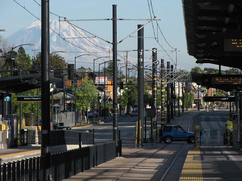
In debating the relative merits of transit and bike priority in the Eastlake and Roosevelt corridors, it’s easy for each side to instinctively defend their own prior preferences. But largely unanswered in the debate so far is the fundamental existential question about the corridor, namely: How important is it from a mobility perspective, and for whom?
SDOT’s continued prioritization of the corridor, and its inclusion in Move Seattle, goes against Metro’s own planning instincts. Metro, having noted the poor off-peak performance of former Route 66, decided to break the corridor in two for the ULink restructure, and add peak-only service from Northgate (Route 63) and Roosevelt (Route 64) to South Lake Union to compensate. And we’ve already catalogued the dwindling importance of the corridor from a policy level, from the McGinn-era “rapid streetcar” dreams to the dangled possibility of real Bus Rapid Transit, to the current concept of modest improvements, electrification, and protected bike lanes.
So then, a question that needs answered: In 2021, which trips would be faster by bus, by Bus + Link, and by Link alone? With an educated guess of 20 stops in each direction, there are total of 380 possible trip pairs, and I won’t analyze them all. Rather, I’ll look at travel times for every southbound stop to each of the 6 major destinations along the corridor: Maple Leaf (75th), Roosevelt Station (65th), UDistrict (45th), Eastlake (at Lynn), South Lake Union, and Downtown.
One of the first things to note is that for all the proposed investment, baseline travel time would still be worse than today’s scheduled times. Travel time improvements are relative to worsened baseline assumptions for 2021, not today’s travel times. Nearly all of the congestion is between Downtown and the UDistrict, with a travel time of 40 minutes to travel 3.8 miles (an average speed of just 5.7 mph). The trip from Roosevelt to Northgate is projected to much speedier, traveling the final 3.4 miles in just 16 minutes (average speed of 12.75 mph). Average speed for the entire end-to-end corridor would be roughly 7.7 mph.
Link, of course, will be 5 times faster from Westlake to the UDistrict (8 minutes), 5 times faster to Roosevelt (10 minutes), and 4 times faster to Northgate (13 minutes). Average corridor speed between Northgate and Downtown will be roughly 35 mph. So it’s clear from the outset that the bus corridor will serve primarily a shadow function, either connecting riders to their nearest Link station or facilitating trips between two in-between destinations (say, Eastlake to Ravenna Boulevard).
But from my attempt at a travel time analysis, assuming 6-minute frequencies on both Link and bus, it’s even trickier than that. For most riders, Link alone, the bus alone, or a simple same-direction transfer between bus/Link will yield the fastest trip. But if the analysis is close to correct, there are several major trips for which a 3-seat ride (bus-Link-bus) or a backtrack (Link to bus) will be faster. Prominent among these are trips to South Lake Union from Northgate, Roosevelt, or even the UDistrict, for which backtracking from Westlake will save time. Others fast backtracks are Westlake to Maple Leaf (via Northgate), or Westlake to Upper Eastlake (via UDistrict Station). Trips from Maple Leaf to Eastlake or South Lake Union would be fastest via a 3-seat ride, using Link between UDistrict and Roosevelt in between two bus trips.
Bellevue’s City Hall. The protected views would have been from the balcony and a public area inside.
Last month, Zach explained how a view of Mount Rainier from Bellevue City Hall had become a roadblock to rezoning of several redevelopable sites near the East Main Link station. Last week, the Bellevue City Council voted 5-1 to not retain the view corridor. While the rezoning process is not over, this decision makes it much more likely that the East Main station walk-shed will support much higher development densities.
Bellevue is engaged in several rezoning efforts. The East Main Citizens Advisory Committee (CAC) is reviewing the area immediately adjacent to the East Main station. The Downtown Livability CAC has made recommendations for areas which include the Sheraton site northeast of East Main, and most directly within City Hall’s view of Mount Rainier.
The goals around the station are commendably ambitious. Current height limits of 75-90 feet may be increased up to 200 feet at the Sheraton site, and up to 300 feet on lots to the south (including the Red Lion across from the station). The current FAR of 3.0 on the Sheraton site, and just 0.5 further south, would increase up to 5.0.
Bellevue City Council Chambers, and an adjacent balcony and interior concourse, enjoy a view of Mount Rainier over these sites. Current zoning doesn’t allow buildings tall enough to impinge on those views, but preserving the view would require that portions of the Sheraton site in the view corridor be built up to no more than 91 to 117 feet, and portions of the Red Lion site be no taller than 123-148 feet.
Council Members opposed to mandating a view corridor cited the detrimental impact to likely development. Kevin Wallace, in an earlier meeting, described the view corridor as “extremely close to a regulatory taking” because it had not been considered before developers began planning for the site.
OneBusAway, one of the essential transit rider tools available to us, has unveiled its updated Android app with a major redesign to its interface. The app now adheres to Google’s “Material Design” guidelines, emphasizing the use of “cards” and responsive animation, bringing a modern look that is a far cry from the bland look of yesteryear.
In addition to the redesign, the app now features live trip status and displays real-time positions of buses on a given route. The live tracking also features fleet numbers, allowing transit nerds to select their bus type of choice and ensure that they never trip over the stairs of a high-floor bus ever again.
The app still displays real-time arrival information for participating systems (as of this writing, King County Metro, Pierce Transit, Intercity Transit, and Washington State Ferries) and scheduled arrivals for other agencies (including Community Transit, Everett Transit, Sound Transit’s Sounder commuter rail and Link light rail, the King County Water Taxi, and Seattle Streetcar). The app also has an online client, an iOS app on the App Store, and Windows Store app (for mobile and desktop).
A front-page story in yesterday’s Times ($) describes a study that shows much higher property values around light rail stations. “Studies” that come from local firms trying to generate PR deserve some skepticism. Nevertheless, I think their headline writer is trying to spin this as a bad thing: “To live near light rail in Seattle, you’ll have to pay up, study shows.” Clearly, though, the obvious conclusion is that light rail is a huge improvement to neighborhoods, an improvement that people are willing to pay for.
Moreover, there is far more demand to live near light rail stations than than there are homes. A housing shortage is a product of both bad zoning and not nearly enough stations. A coherent response would both upzone and build more stations.
Somehow, the Times editorial board is opposed to the latter. Their headline is even refuted by the article’s own map, showing median homes for less than $275,000 near some stations in South King County. This is way below the King County median, the Snohomish County median, and is near the Pierce County median.
However, I have to credit the editorial staff for publishing a front page story that, to the mildly economic literate, suggests that light rail is a boon to neighborhoods. It does make you wonder about the thought process of Surrey Downs and “Save Our Trails” NIMBYs who have done everything in their power to keep away high property values and convenient transportation.
Bike and transit advocates share many common goals. We all want walkable and bikeable cities alongside (or atop) fast and reliable transit. But potential fracture points have arisen between the sometimes competing visions of the Center City Bike Network (and the broader Bike Master Plan), Move Seattle’s Rapid Ride corridors, and the sudden entry of a new process layer in the Center City Mobility Plan. The challenges are real and it’s imperative both that bike and transit advocates work together for each others’ mutual benefit, and that we understand each others’ biases and policy preferences.
To that end, please join us Tuesday from 4:30-6:00pm in the Bertha Knight Landes room at City Hall for a discussion with Transit Center Policy Director Jon Orcutt. The topics couldn’t be timelier for Seattle, including “(1) a discussion of bike/transit integration in urban areas, particularly downtowns; (2) bike network connectivity and its import; and (3) rapid implementation of bike networks.”
STB is co-sponsoring the event with Councilmember Rob Johnson, Cascade Bicycle Club, Commute Seattle, Futurewise, Seattle Bike Blog, Seattle Neighborhood Greenways, Transportation Choices, and The Urbanist. They do ask for an RSVP here.
Growth skeptics love to complain about South Lake Union. It’s too sterile, too corporate, too luxury — it couldn’t possibly help address housing affordability.
I never bought into that — just building units does a lot of good for the region — but give it just a little time, and districts like SLU can solve the problems that growth critics claim to care about. Exhibit A: Crystal City, Virginia ($), a soulless 1980s sea of single-use office buildings, now in hard times due to defense cuts:
At first glance, there appears to be nothing new among the high-rise offices and apartments lining Crystal Drive and its bisecting streets in this Arlington County enclave. In fact, there is little new construction. Instead, buildings from the 1960s to 1980s are being retrofitted, some converted from offices to apartments, others welcoming new commercial tenants, including tech start-ups, co-working spaces and restaurants.
The area… is attracting residents and younger workers with competitive rents and convenient transportation options.
Perhaps this won’t be SLU’s fate: I’ve spent enough time in both to know that it is a much better urbanist space than its counterpart. It may continue to thrive as a regional economic driver. This wouldn’t be a bad thing! But in the long term, SLU will either succeed or it will fail, and in either case all of these buildings developers are putting up will do Seattle a lot of good.
Of all the good urban problems to have, an overactive downtown core is among the best of them. We’ve come to the point where a weekday/weekend transit service dichotomy is too simple to adequately respond to unique changes in demand or stresses to the system. From Pride, SeaFair, Rock and Roll Marathon, Obama x 3, Xi Jinping, and on and on, there are ever more days each year in which unique pain points occur for Downtown service.
The impetus for this post, of course, is Obama’s visit yesterday. Walking along Stewart in the PM peak, it was a wall of continuous gridlocked buses from Harrison all the way to 6th, burning fuel, transporting no one, and wreaking havoc on the broader transportation network. The poor Tacoma drivers operating Sound Transit’s 590s were diverted onto westbound Denny, woefully stuck with everyone else.
At the ST3 Board Meeting last Thursday, CEO Rogoff gave his customary ridership update, and disclosed that not only will ST be tripling 3-car trains on weekdays, but will also be looking at turnback trains between UW and Sodo for special events. Previously, this idea was limited to helping bridge the 2 years between Convention Place closure and Northgate Link’s opening. But why should event-related service improvements be limited to trains, when buses and their crazy reroutes bear the brunt of the pain?
A proposal: its time for a new “Enhanced Weekend/Event” layer of service. Here are some possible criteria: If both of the following are true, operate “Enhanced Weekend/Event” service:
Sound Transit expects weekend/ridership to be within 10% of weekday ridership
Buses will be rerouted by 2 blocks or more for 4 or more hours that day
If buses cannot serve the downtown core, and if the stops they serve are duplicated by Link, those buses should not serve Downtown at all. Routes such as 255, 545, 554, 578, and 594 should run to their nearest Link station, and run twice as often.
In turn, Sound Transit should operate Link with equivalent weekday capacity, just spread out evenly throughout the day. So instead of 10-minutes off-peak and 6 minutes peak, run it 7-8 minutes all day.The truncations proposed could also apply on weekdays for limited but severe stresses like Presidential motorcade closures.
Surely a forced transfer is preferable to a bus that’s an hour late, and buses idling with no passengers are in nobody’s interest. What do you think?


.jpg)

