
Rainier Avenue Must Choose Between Buses and Bikes

Rainier Avenue is one of the more dangerous roads in Seattle. SDOT says that the road has averaged one crash per day over the past 10 years. Phase 1 of Seattle’s approach to fixing it took it from four lanes to three between Kenny (near Orcas) and Alaska Streets, added some transit queue jumps, and reduced speed limits. Although it’s about a minute slower to drive through the corridor, collisions are down about 15%, and Northbound transit times improved 3 minutes.* Vehicle volumes dropped on Rainier, though they increased on MLK a similar amount.

Now it’s time for Phase 2. The next segment continues the revision from S Kenny St. all the way down to S. Henderson St. The 4-lane-plus-parking roadway will transform into one of two alternatives as early as next year [edited], but they involve difficult tradeoffs:

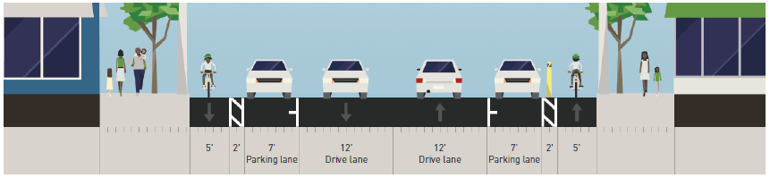
Alternative 1 turns one traffic lane into a center turn lane, and one into a Northbound bus lane. This transit improvement anticipates Metro and Seattle upgrading Route 7 to RapidRide.
Continue reading “Rainier Avenue Must Choose Between Buses and Bikes”

SDOT September 2017 Service Investments

map showing coverage of Seattle's transit network by frequency, most of the city is covered by 15-minute servuce
September investments bring 10-minute service to much of northeast Seattle (graphic: SDOT)

The footprint of Seattle’s frequent transit network is expanding this September thanks to service investments funded by the voter-approved Seattle Transportation Benefit District (STBD). Routes 65 and 67 in northeast Seattle and Route 60 connecting Capitol Hill and First Hill with Beacon Hill, Georgetown, and West Seattle are getting a boost in weekday frequency.

SDOT presented its STBD September investments to the City Council’s Sustainability & Transportation Committee last month. The route selection was informed by a Race and Social Justice (RSJ) analysis that SDOT completed in spring. It identified a lack of 10-minute service in northeast Seattle serving low-income & minority communities and infrequent east-west service in south Seattle.

Route 60 joins the Frequent Transit Network with weekday service improved to every 15 minutes or better from 6 am to 7 pm. Currently service runs every 20 minutes midday and every 15 minutes in the peak direction during peak hours. Weekend and evening service remains every half hour. South Park and Georgetown will now have a frequent connection to White Center, Beacon Hill, and beyond.

Metro’s 2016 Service Evaluation report lists Route 60 second among corridors that need investment to meet target service levels. It is also marked as needing schedule reliability improvements.

Routes 65 and 67 are improved to run every 10 minutes or better on weekdays from 6 am to 7 pm, instead of every 15 minutes currently. This brings the 67 up to service levels Metro proposed in its first draft of U-Link Connections. Both routes will have late-night service as part of the night owl overhaul that also begins this September.

That improvement means 64% of Seattle’s households will be within a 10-minute walk to 10-minute transit service, up from 51% last year and surpassing the 2020 goal of 53% three years early. The city is aiming for 72% by 2025.

Another improvement of note is to Route 50 which connects the Rainier Valley with West Seattle via SODO. Service will be improved to every 30 minutes or better for 18 hours a day, every day of the week. Currently the 50 runs hourly after 8 pm on weekdays and all day Sunday.

News Roundup: 100%

Mike Bjork/Flickr

This is an open thread.

An OBA Hack for Multiple Stops

The complexity of our bus system often presents power users with a dilemma. There are often multiple ways to get to a destination, and the bus to take often depends on which one comes first. Sometimes, it’s a choice whether to travel east-west or north-south at start. In other cases, extreme bus density downtown means routes to the same place stop in as many as three different places. Juggling arrival times can be hard. However, there’s an undocumented OneBusAway hack for that.

As reader Tim Bond explains, just type in and bookmark the URL you need. The format is:

http://pugetsound.onebusaway.org/where/standard/stop.action? followed by stuff, where each item is separated by a “&.”

Each stop is represented by an ‘id=1_’ followed by the stop number.

Each route follows its stop number with a ‘route=1_’ followed by the route code, which doesn’t always relate to the actual route number. You can get these numbers by clicking around regular OBA pages.

For instance, the query below will give you all the options to get from the Westlake area to the west side of Lower Queen Anne, on the 1, 2, 13, 24, 33, or D. The stops are 575 (Routes 1, 2, and 13), 578 (D), and 590 (24, 33).

http://pugetsound.onebusaway.org/where/standard/stop.action?id=1_590&route=1_100132&route=1_100194&id=1_578&route=1_102581&id=1_575&route=1_100001&route=1_100089&route=1_100028

The result is shown at right.

Pierce Transit considers HCT on Busiest Route

HCT study area Image: Pierce Transit

To establish a north/south link in the heart of the county, Pierce Transit is weighing the potential of high-capacity transit (HCT).

These systems, designed to carry a larger volume of riders with greater speed, reliability, and frequency than a standard fixed route bus system, can operate either on a dedicated track or lane, or on existing streets in mixed traffic.

With a goal of increasing bus speeds and ridership, in February the Pierce Transit launched a HCT feasibility study along Pacific Ave South (SR 7) between downtown Tacoma and Spanaway. The transit agency said ridership and cost will determine the most appropriate HCT mode, which could include rail, streetcar or bus rapid transit (BRT).

Building a high-capacity transit along this corridor has been in Pierce Transit’s plans for many years, said Alexandra Mather, a government and community relations officer for the agency.

“The economic downturn in 2008 required the project to be put on hold,” Mather wrote in an email. “Fortunately, with sales tax revenues up in Pierce County and successful funding out of the state’s 2015 Connecting Washington package, as well as a $60 million capital commitment for transit speed and reliability in the corridor from ST3 (Sound Transit Three), the project was made a priority for the agency.”

Continue reading “Pierce Transit considers HCT on Busiest Route”

Spokane Transit Begins Implementation of STA Moving Forward

The Empire Builder at Spokane WA. ( 4 Views )

STB hasn’t written much in-depth about transit in Spokane since the passage of their scaled back STA Moving Forward initiative in November of last year, which followed the failure of the original package in 2015. To catch up on the Spokane Transit Authority’s progress in implementing Moving Forward, I reached out to Director of Planning and Development Karl Otterstrom. What follows is a lightly-edited transcript of our email interview.

Seattle Transit Blog: What parts of STA Moving Forward have been implemented or are currently in progress? I know there’s been some service improvements, you’ve got new artics on the way, and you’ve broken ground on the West Plains Transit Center.

STA Moving Forward is a ten-year plan for more and better transit service. It is phased to avoid debt and make implementation more manageable. As part of the effort behind the second ballot measure in November 2016, the STA board directed us to accelerate elements that could move forward sooner. Part of our response was introducing new service at both the May and September service changes. In future years we intend to make STA Moving Forward service adds just once in a calendar year, devoting other service changes to timepoint adjustments and other minor revisions as necessary.

IMPLEMENTED: During the May service change, we added the following service:

Continue reading “Spokane Transit Begins Implementation of STA Moving Forward”

Downtown Bellevue to be rezoned

The rezoning will increase capacity near I-405, rebalancing growth in other neighborhoods.

Bellevue is nearing approval of a comprehensive update to downtown zoning. It could mean taller buildings up to 600’ in some areas of the downtown core. It’s the culmination of a multiyear process to improve downtown livability, improving the pedestrian realm and fostering a more distinctive skyline. Approval by the City Council is anticipated this Fall.

Despite fairly significant increases in allowed height, the zoning update is not intended as a major increase in developable capacity. Buildings may be much taller, but not much greater in mass. Increases in FAR (floor/area ratio) are limited in most of downtown. The goals are slimmer and more diverse building forms, and more public space and sunlight at ground level. Many in the city leadership view downtown buildings as too uniform, making for a sometimes dull skyline.

The most unambigous upzones are in the OLB zones between 112th Ave and I-405, and around the future Downtown Link station. This area is conspicuously under-zoned today, with height limits of just 75 to 90 feet. Those would increase to 200 feet south of NE 4th, and 350 feet north of there.

Elsewhere, the rezone redistributes growth within downtown, often equalizing what are now different height limits for residential and commercial towers. The net impact is to encourage more residential towers in the corporate-heavy center of downtown, while making office development easier in some areas around the core that have recently seen mostly residential development. That’s something of a policy reversal. Previous zoning had encouraged office development in the tallest part of the “wedding cake” with more residential on the outer areas of downtown.

In the center of downtown, permitted height would increase from the current 450 feet to 600 feet. But, maximum FAR limits would remain unchanged. Other restrictions on building form will encourage slimmer residential buildings, particularly if developers take advantage of the height increase.

Continue reading “Downtown Bellevue to be rezoned”

Community Transit Proposes “Simpler” Fare For Some Commuter Routes

CT 23800 at Lynnwood TC
Route 421, one of several commuter routes affected by the fare policy change

Community Transit is proposing a small fare policy change for next year, as part of preparation for the next-generation ORCA system planned to launch in 2021. If approved at next month’s board meeting, the fare policy change would eliminate a lower-cost fare used on commuter routes by riders who only ride within one or two zones. The change comes as part of a region-wide push to streamline fares for the next-generation ORCA system, which will already be limited in some ways.

As it currently works, a rider in Lynnwood who is bound for Marysville can take Route 421 (the Seattle-Lynnwood-Marysville Express) and only pay $2.25, the regular local fare, as opposed to the $5.50 fare charged for commuter routes from the North and East ends of the county. Route 421 is also able to carry Seattle-Lynnwood commuters and charge the South County fare ($4.25) through the same arrangement. Riders request the lower fare from the driver, who will either accept the lower cash fare or manually override the ORCA reader with the Local or South County fare option, before switching back for the next person in line.

Continue reading “Community Transit Proposes “Simpler” Fare For Some Commuter Routes”