Page Two articles are from our reader community.

North by Northwest 66: Go Try Out Community Transit’s Trip Calculator…

Figure you might want to consider calculating the cost of your commute sometime.  Might be a good idea to use the Community Transit trip calculator to do so.

Also, listen I hate rude people okay, but unless you want to buy up a tiny but sporty Toyota Yaris like a relative did for a while, maybe you should save money and Dump the Punp.

View post on imgur.com


My Toyota Yaris photo from my amateur photography days – pardon the low quality

Or you can get a Ford Focus

https://flic.kr/p/oXDNBV
Flickr photo by Ford Europe used under noncommercial license

Or you can really think long and hard about your transportation choices versus the money you’d be saving.  About 30 miles per gallon going from Mukilteo to Seattle in a small car like the above is the tipping point back in favor of the car over the bus…

Up to you.  I so prefer the view from King County Metro 124… and riding what I see below when I’m in Seattle:

Enjoying Light Rail Out the King County Metro 124
My photo

It’s your money.  Give the cost calculator a go.

North by Northwest View 18: What Should I Ask North by Northwest Transit Agencies about…

A Light Rail Driver and A Passenger Wave
My photo: A Light Rail Driver and A Passenger Wave

This should have happened long ago, but with Thursday evening’s Sound Transit 3 meeting knowing Community Transit & Everett Transit & more will be there, thought I’d let you plant some questions into my mind.

I already got several that went from ideas to words, thanks to Mike Orr, so let me start with his help:

  • What is the projected ridership for a Lynnwood – Paine Field – Everett CC corridor and where do those people live?
  • How would workers get from Paine Field Station to their scattered jobs in the Paine Field industrial complex – whether at museums or flight schools or industrial?
  • How will a Link route service Mukilteo and other points west towards the coast?
  • What barriers are there to hourly if not half-hourly transit service from Seaway Transit Station to Hwy 525 & 84th St SW if Community Transit gets its transit levy lift?
  • What if Paine Field does get its passenger terminal – what then in regards for transit?!?
  • What if Sound Transit 3 only has $12 Billion of taxation authority, what then?
  • How does the Mayor of Everett’s Office respond to the current issues around lack of transit ridership to Paine Field?

Plant a few more questions in the comments if you would please.  As I cannot edit this post, I think I’ll post my final question list in the comments as well.  So make sure to follow along here…

NORTH BY NORTHWEST 65: FUTURE OF FLIGHT DEFEATED IN GETTING IMMEDIATE TRANSIT SERVICE

The Future of Flight W/ A Dreamlifter Nose Sticking Through...
My Aerial Photo: The Future of Flight W/ A Dreamlifter Nose Sticking Through…

Well folks, it is my displeasure and sadness to report that any short-term fix to the Future of Flight getting transit service is a nonstarter.  Last week, I learned Community Transit has vetoed changing Community Transit Route 113 to support the Future of Flight due to scheduling concerns and inconveniencing local Community Transit users for international Future of Flight visitors.  This defeat of getting public transit services to the Future of Flight however in the short term is ultimately because the better argument won inside Community Transit; and I accept full and total responsibility for the failure to succeed this time around.

I acknowledge the difficulty of asking a transit agency to change a transit schedule broadly advertised and should be reliable to the taxpayers to magically change a community’s main route to service a major tourist-powered economic engine.  A proposal that the Mayor of said community was apprehensive about in a North by Northwest Big Interview.

Some will ask, “Why not Everett Transit?”  Believe me, I have.  I went to the Everett Transit August 2015 Service Change Proposal public meeting at Thursday, April 16, 2015 where senior Everett Transit leaders and I discussed potential options for the Future of Flight.  One option thoughtfully proposed was an express shuttle linked to Everett Station.  One option frankly is insulting – and that’s the Everett Transit Planner’s demand of direct Future of Flight funding for Everett Transit service as if magically the nonprofit Future of Flight can write a check.  I also learned at this meeting from the Everett Transit Planner that hourly Everett Transit service to Boeing’s Paine Field factory and even with three Boeing employees helping get Boeing employees to choose transit first was not going so well so there’s understandable Everett Transit reluctance to further service Paine Field.  One would hope the Everett Mayor will listen rationally to Everett Transit staff before further championing light rail to Paine Field without firing Everett Transit professionals championing data-based contrarian viewpoints.

Speaking of comments, let me be clear, read carefully trolls: To lob from the dark corners of the room the hecklers’ veto and snipe at a major nonprofit doing good works is a classless disgrace and speaks volumes about how some transit advocates misperceive their role.  Make no mistake, I am confident other nonprofits who need transit service are going to keep their hands down and point to your sniping as a reason why not to ask for help. Running a mostly positive campaign clearly has less weight than that of anonymous coward internet trolls sniping because some people are unhappy with their transit service levels now means less transit for all.  Some heckler’s veto to celebrate.

That said this is all in the past. There is one good option left not just for the Future of Flight but also for giving Mukilteo a fair slice of transit service.

If we can get the City of Mukilteo City Council to please pass a resolution as a part of this Community Transit levy lift to request a bus route from 84th Street & Mukilteo Speedway to Seaway via Future of Flight so as to link Seaway Transit Center to the Mukilteo Multimodal Terminal in 2020 & the City of Mukilteo… but this route request requires Mukilteo community support, a bold investment of the City Government of Mukilteo’s political capital, and Community Transit to get its levy lift at the ballot box.

Arguably best to get the Seaway to Mukilteo connection is via commenting on the 2016 Transit Development Plan (TDP) for Community Transit.  In a recent public records request, Community Transit’s Public Records Officer wrote, “The full text of each comment received was provided to board members, initially to the board committee reviewing the plan, and then to the full board.  Comments were discussed in the context of the plan.  The final adopted plan includes the full text of each comment.”  When asked to share route planning for the Seaway Transit Center, Community Transit also replied, “There is no specific route planning for the transit center at this time. It’s too early in the process.”  Therefore a letter from the Mukilteo Mayor coupled to a Mukilteo City Council Resolution would certainly influence Community Transit’s “route planning”.

I will conclude with the genuine concern I have a Community Transit levy lift is going to require transit advocate enthusiasm to win. I know many share my fear a Sound Transit 3/ST3 package that rewards Seattle/North King insufficiently will not be pushed over the top.  So I legitimately fear a Community Transit levy lift transit package that insufficiently excites Mukilteo and Everett will ultimately fail.

Over to hopefully thoughtful comments at 777 words…


Programming Notes: Tomorrow I will post a North by Northwest View 18: What Should I Ask North by Northwest Transit Agencies about…

Also since I am no longer able to edit what’s posted to Seattle Transit Blog and writing this post is rather emotional for me, I drafted in Microsoft Word.  I encourage other Page Two writers to do the same.

Message to ERC Trail Proposal Planning Committee: Design for Rail

Written By Andrew Stephenson, 13 June 2015

Sent To the members of ERC Trail Proposal Planning Committee; ERCtrail@kingcounty.gov

Greetings,

In your hands is the future of the Eastside.  In the midst of the biggest infrastructural revolution since the dawn of the Federal-Aid Highway Act of 1956, cities have recently reinvested billions solely into mass transit, bike trails and better walkable communities, attracting Millennials and retiring Boomers in the tens-of-thousands.  The current ERC bike trail proposal only addresses the need for a bike trail, naturally, continuing the “suburbia culture” of drive-drive-drive, spending every hour not working sitting in traffic congestion, dropping-off and picking-up people you know without cars, due to the lack of TOD planning.  The valuable time left at the end of the day not spent commuting is used to exercise, in this case: on the ERC trail.  In 10 years, there will be no time left after one’s commute for any activity whatsoever.  The future involves incorporating activity into your commute and avoiding traffic gridlock, whether that involves commuting by bicycle or walking to the train station.  The ERC trail addresses only commuting by bicycle, this is not an appropriate investment for the fastest-growing metropolitan region in the nation. To accommodate bicyclists is a significant achievement, a recently acknowledged mode of transport for this nation, but will not improve Eastside mobility nor attract Millennials and techies from Seattle whom are desperate for a “car-less” lifestyle.  Addressing only one issue along a corridor that can support two modes of transportation is comparable to a D+ on your exam.  Take this rare opportunity to use the ERC, a grade-separated, tree-lined (thus sound-mitigating) right-of-way to please bicyclists, families, motorists, tourists and transit users alike. This is a two-in-one opportunity.

For the sake of our future, it is imperative that you include and leave room for a double-tracked electrified heavy-rail line in the design to parallel the bike trail on the ERC alignment.  Having world-class rail infrastructure in addition to a paved trail for cyclists to commute on will make Bellevue the centerpiece of the rapidly growing Eastside, promoting Bellevue as a potential economic competitor to neighboring Seattle.

Yours sincerely,

Andrew Stephenson

President, Developing Sustainable Communities, Washington State University

I have only posted one other time here on STB Page 2 which also concerned the ERC for heavy rail, an important connection between Eastside communities that could be voted on and approved in 2020 and easily completed no later than 2025 due to its conveniently unobstructed right-of-way.  I suggest others on the Eastside also enthusiastic about using the ERC for heavy rail to email the ERC trail proposal committee like I have.

Thanks everyone,

Andrew Stephenson

North by Northwest 64: Update on Paine Field…

Here in Nikon D5300 Minature Mode is Historic Flight Foundation at 10 AM On Paine Field Aviation Day at 10 AM
My aerial photo: Here in Nikon D5300 Miniature Mode is Historic Flight Foundation at 10 AM On Paine Field Aviation Day at 10 AM^

Figure since many of you in the Seattle Transit Blog comments have some concerns about future Paine Field transit service and in particular light rail… let me give you some updates:

  • Beacon Publishing is doing a survey on transportation with emphasis on the proposed Paine Field passenger terminal.  Some would say supporting a commercial terminal at Paine Field means supporting light rail to Paine Field…
  • Today, and I’m sure this will be covered more thoroughly on Page One, Sound Transit has a new website for ST3.  One part is a survey on what projects for ST3.  If you have an agenda you want to accomplish or help accomplish*… vote and ditto at the upcoming meetings where other local transit agencies will also participate such as the 18 June meeting at Everett Station which I will attend.
  • The Everett Herald kindly posted an update on conversations the Future of Flight and Community Transit are having about weekend transit service to Future of Flight as an initial hydration to the transit desert.  As I said to the Everett Herald, “The Future of Flight deserves a fair slice of service and this is a significant step in that direction.”  I don’t think light rail is that “fair slice of service” any longer but feel the Future of Flight, the #1 tourism destination for Snohomish County with 777.8 daily visitors – many of which international who rely on mass transit back home – needs a “fair slice of service”.  Another option I am now proposing is for that “fair slice of service” being an express bus route from Seaway Transit Center at the east end of the Boeing Paine Field campus to Future of Flight and then Community Transit Route 113…

There you go.

—FOOTNOTES—

^Yes, I write long photo titles :-).  I also wanted an aerial photo that showed more than the Future of Flight.  Below Historic Flight Foundation/HFF will be a major park & ride in a few years.
*Help accomplish like light rail to Ballard, I just expect support for more, better bus service to all Paine Field tenants in return from you commentors.

North by Northwest View 19: Time for Camano Island to Pivot to Community Transit?

A Quick Snap of Island Transit Route 411C
My recent photo of an Island Transit 411C Camano Bus

Full disclosure: The below letter to the editor by me ran in the Stanwood-Camano News today.

Bus service

Camano should switch to Community Transit

Dear Editor:

Island Transit is removing its county connector services from Whidbey to Skagit.

This is after the unilateral withdrawal of the Camano to Everett Island Transit connector service last June. Without state support, Island Transit cannot continue to provide those services. Representative Dave Hayes has finally proposed a fare on Island Transit in return for some state support.

But perhaps I have a thought for my Camano Island friends: Maybe with the lassitude that Island Transit board meetings are run, where charging a fare to reenlist state support in many meetings since November when the county connector crisis came to light has not happened and with the Island Transit board being so inaccessible to Camano Island.

Perhaps the time is right for Camano Island to change to Community Transit as your transit provider.

At least Community Transit’s finances are in great shape. has good public communications and is about to seek a three-tenths of 1 percent tax increase to dramatically increase service. Can you say any of those things about Island Transit?

Just something to debate – namely changing transit taxing districts to get a better provider.

Figured some of you in the transit advocate community would want to discuss this.  Island County Commissioner Rick Hannold also told the Stanwood-Camano News in part:

The board is not sure how long the routes will be cut. Hannold said they are investigating the initiation of a fare system that would help to alleviate the burden of the 411 routes’ additional expense.
“I’ve been pushing for a fare system since the get-go,” Hannold said. “Riders need to have a stake in this; it doesn’t come for free.”
A fare system, he said, would be helpful in many ways.
For one, the House and the Senate have approved funding for the Everett connector, Hannold said, though it is awaiting the governor’s signature. To benefit, though, Island Transit is required to include fare boxes in each of their buses.
Additionally, if fare boxes are installed, Island Transit can apply for Medicaid reimbursement for paratransit expenses –a special service for disabled individuals not accommodated by the regular bus service.
Paratransit costs Island Transit approximately $1.5 million per year.
In April alone, Hannold said, the cost for paratransit services was $70,000, while Island Transit spent $180,000 on all other services combined.
“It’s costing us so much, and we’re required by law to provide it,” he said. If they could alleviate some of the cost associated with that service, Hannold thinks money could be redirected toward other things, which may include reintroducing the 411 routes down the road – a service that has cost them around $500,000 over the past six months.
“We just don’t have it,” Hannold said.

Figure this will help fuel the debate that should have happened, like oh, last November.  I even had inside information on 2 July of 2014 this was a distinct possibility.  Yet no action until too late… the blame falls on both Skagit Transit & Island Transit for not being proactive with contingency planning for this day.

Move the 255 Out of the Tunnel and Move Other Buses In

The question of which buses should be in the tunnel has been asked in at least two different ways. Right now, the buses that are slated to remain are the 41, 74, 101, 102, 106, 150, 255. I agree with David Lawson, that the 255 should be removed. I think it should be replaced by either the 77 or the combination of the 76 and 316.

One of the big advantages to the bus tunnel is that it feeds very well into the express lanes. The 255 does not use the express lanes, so it does not gain much of an advantage (if it gains one at all) by using the bus tunnel.

It also makes sense to cluster similar bus routes into the tunnel, or out of the tunnel. The old 71,72, 73 and 74, for example, all served the U-District, and they all went in the tunnel. This meant that someone headed to the U-District from downtown simply waited for the first available bus starting with a “7”. The 255 doesn’t pair well with any other bus that travels in the tunnel. It is possible that someone might want to head to Montlake on either the 255 or Link, but I doubt very many.

The buses that use (or could use) the express lanes, but are not slated to use the tunnel are the 76, 77 and 316. By my estimation, they make the following number of trips:

76 — 11 trips at rush hour.
77 — 8 trips at rush hour.
316 — 11 trips at rush hour.

By removing the 255, we would remove 23 trips at rush hour. So, obviously, we can’t put all three in the tunnel. Each bus overlaps (or shares) some of the other routes in the tunnel, so there are several possibilities. These are the two that I believe make the most sense:

76 and 316 — They both serve the Green Lake Park and Ride. They diverge from there, but since there are a lot of transfers from there, and this a fairly populous area, the shared ridership is probably significant. In addition, the 76 and 74 are close enough in service area to have significant overlap (for those who live in between the routes).

77 — The 77 and 41 both serve Pinehurst (NE 125th and 15th NE). This also means either one works as the first bus to the 347/348. In addition, those headed to the area served by the 77 can take a 74 (or Link) and then transfer to the 73 or 373 instead. Replacing the 255 with the 77 would mean significantly fewer buses in the tunnel. This could improve reliability in the tunnel, especially for Link.

Either option (either the 77 or the combination of the 76 and 316) would be an improvement over the 255. The 255 does not take advantage of one of the best features of the bus tunnel (its connection with the express lanes) nor does it’s service area overlap with buses that will be in the tunnel.

What Public Transit Looked Like in 1939 Seattle

The Seattle Room, on the top floor of the Seattle Public Library, is a great place to get lost in for a few hours.  A few years ago, looking around for old documents about the Alaskan Way Viaduct, I stumbled across a book detailing a proposal to redesign the Seattle transit system back in 1939.

Inside this book were two really interesting maps, one showing the existing system in 1939 and the other detailing a proposed overhaul of the whole system using only buses (using both electric- and gas-powered coaches).  I photocopied the two maps, scanned the photocopies (pasting the odd-sized maps together with MS Paint), and now that I remembered I had them, put them online.  Here is what public transit looked like toward the end of the Great Depression:
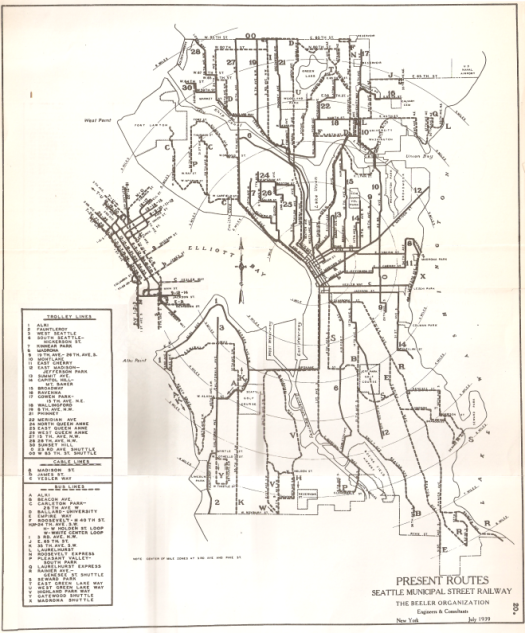
1939 Seattle Public Transit System Map

A Patchwork System

As mentioned in Vox not too long ago, trolley service had been in decline for decades by the Great Depression, and not just because of the automobile.  Many streetcar operators were hampered by contracts that prevented raising fares to pay for escalating operating costs.  This also prevented expansion of any streetcar system, as seen with Seattle’s myriad of bus routes operating shuttles and connectors on the fringes of the city and in places where expansion of a particular rail line might otherwise seem more logical (like Route X along Lake Washington Blvd.).  Other factors, like congestion (which streetcars couldn’t avoid well) and the increased affordability of private vehicles, made streetcars all the more obsolete.

Still, even in 1930’s Seattle, it seemed that streetcars were expected to stick around: one of the first things you might notice about the system map is that the numbering scheme seems backwards. Streetcar routes use numbers, while gas-powered bus routes use capitol letters.  As you can see from the map, they were quickly running out of letters for their buses.  Perhaps using letters for bus routes signified a desire to keep streetcar route numbers intact – after all, they have been used for decades by that time.  Perhaps planners thought gas-powered buses were merely a stopgap to use until trolley lines were extended into those new neighborhoods.

Most likely, they didn’t think that far ahead.  After all, two of the glaring exceptions to the above theories are the “R” and “E” lines, respectively serving Rainier Avenue and Empire Way.  These two routes would be as important as any other for the entirely of Seattle’s existence, but trolleys never operated along these major corridors – a sign that Rainier Valley (and, by extension, its mostly non-white population) was disconnected from the rest of Seattle in more ways than one.  Be sure to note that the streetcars from Routes 9 and 14 stay high up on Mt. Baker, since there would be little interest in connecting to the valley below.

(Not that this should explain the dangling appendix that is the Mt. Baker portion of Route 14 still in use today, judging the residents of the valley below with its fancy-pants hilltop boulevard turnabout… wouldn’t Route 14 drivers rather terminate near the Safeway down the hill?  Just curious.)

The next thing you might notice about the map in general is that the transit corridors themselves haven’t changed all that much over the last century, even though the route numbers have (except Route 14 in Mt. Baker… that route seems to be the only one to survive the streetcar-to-bus transition intact).

In fact, aside from a few deviations into Ballard and Columbia City, only Route I along 3rd Avenue (N)W is significantly different than today, and was probably abandoned due to a combination of being exactly halfway between 1/2-mile-spaced transit corridors (the baseline distance of North Seattle bus routes today), while also serving a relatively-affluent neighborhood (and therefore has less demand).

What you might not be able to see clearly on the scanned photocopy are the three cable car lines:

  • The “a” line traveled along Madison Street, but only between 1st and 14th Avenues.  At 14th, the “a” line connected with the 8 and 12 trolleys, serving Madrona and Madison Park, respectively.
  • The “b” line served James Street between 1st Avenue and Broadway (connecting with the 11 trolley, which continues to Madrona, á la current Route 3).
  • The “c” line was probably the most impressive, running along the entirety of Yesler Way – which included an impressive trestle along the northern boundary of Leschi Park that brought the trolley from the top of the hill down to Lake Washington, connecting to a bus shuttle (the “X” line – a cool designation that route certainly did not deserve).

Quick Sidebar: The Madison BRT Line

I don’t know about you, but I feel that if you are seriously considering a BRT line along Madison Street, you should seriously consider a cable car connecting the “a” and “c” lines above, only instead of 1st Avenue, they should continue all the way down to Alaskan Way and serve the Colman Ferry Terminal as well.

The cable cars should use Madison/Marion Streets between Alaskan Way and 6th Avenue, then continue along Madison Street all the way to Madison Park.  Along Yesler, the trolley would operate to 32st Avenue, then descend Lake Dell Avenue S to Lake Washington Boulevard, like current KC Metro route 27.

Eventually, the trolley could be extended to follow Lake Washington Blvd. through the Frink Park and Colman Park curly-cues – how awesome would it be to ride a trolley though this Olmstead Pleasure Drive?  That could be a real tourist-driven money-maker in addition to providing an attractive alternative to the S Jackson Street corridor.  It could work (as long as the cable car uses the same gauge rails as the First Hill Streetcar, which would provide an incredible connection at the foot of Broadway).

The 1939 Proposal

1939 Seattle Transit Proposal System Map

The proposal is almost as fun to comb over just to see how much of the proposal was not only approved and enacted, but have yet to be changed to this day:

  • Routes 1, 2, 3 and 4 atop Queen Anne Hill have remained virtually the same for seven decades now, with only minor changes to the terminal turnarounds.  Route 1 has also directly served North Beacon Hill until very recently (via through-routing with Route 36).
  • Route 5 no longer serves Lower Fremont, but the rest of the Phinney/Greenwood routing remains the same.
  • Routes 10 and 11 on Beacon Hill remains the same (except for Route 11 operating along E Pike Street).
  • Route 14 was only recently replaced by Route 47 in the Summit neighborhood of West Capitol Hill.
  • Route 16 also still operates portions of the route along Stone Way N and in North Greenlake (this proposed version of Route 16 also serves Rainier Avenue S a la current Route 7, making a monster of a route).
  • Routes 15 and 18 appear to have switched places in Ballard, and Route 18 was moved to 15th Avenue W, but are otherwise still in action as express routes (and this version of Route 18 is currently served by Route 40).
  • Route 17 is also very similar, having detached from the W Nickerson Street routing only a few years ago (except for that weird four-block westward deviation between (NW) 62nd and 65th Streets).
  • Congratulations, Magnolia!  Route 19 is coming back!  That route just won’t die.  Speaking of which, what percentage of Magnolia homeowners do you think are older than this bus route?  I am guessing 40%.
  • Route 21 is unchanged almost to (SW) Roxbury Street, not including additional service added to the south.  (it should also be noted that Route 20 is the direct precursor to current Route 120, unchanged except for the additional service to the south of Roxbury).
  • Route 25 along Lakeview Blvd. and through Portage Bay is virtually unchanged – merely extended into Laurelhurst.

It’s also fun to trace back changes made.  For example, you can see that Route 1 operated to North Beacon Hill; eventually, the Beacon Hill routing got its own Route 36 designation when it combined with what was then Route 26 to serve the entirety of Beacon Avenue (S).

Downhill on Pike Street

You can also figure out something you might not know about the street alignment in Downtown Seattle.  Look at the turnaround for Route 22 in Downtown Seattle) on the map below, circled in purple:

1939 Proposed Seattle Transit Downtown Map

Notice it operates westbound on University Street?  This is the opposite of today, where University Street is an eastbound street that leads to the I-5 northbound on-ramp.  Also notice that Pine Street is a two-way street, which you can tell by the lack of a second corridor for Routes 9 and 10 (which serve Broadway and 15th Avenue, respectively).

This means that Pike and Union Streets each operated in the opposite direction as it does today, with downhill/westbound traffic using Pike Street and uphill/eastbound traffic using Union Street.  I am unsure if this was changed as a direct result from Interstate 5 construction (which destroyed Union and University Streets between 6th and 8th Avenues) or if the realignment happened prior.

Anyway, I have speculated enough – enjoy pouring over these old maps, fantasizing about a Seattle in which trolleys still operated along Pike/Pine!

Proposed Changes to the new 67 and 73

Metro presented its new “Alternative 3″ U-Link restructure proposal. As part of that process, I would like to propose the following changes for the 67 and 73:

1) As David Lawson suggested, combine the 73 and 373 through the U-District.

2) Have the 67 use 5th Ave. NE, instead of Roosevelt Way, north of 80th and south of the transit center. This is the routing that the city is proposing for a new high speed corridor. A shorter, less congested route will make the connection between Northgate and Roosevelt much faster. This will, in turn, reduce the number of service hours necessary for this route, which can increase frequency on this (or other) buses.

A fast connection to Northgate Transit Center is important. This is a major connection point to other buses. For example, if you are traveling from Northwest Hospital to the UW Medical Center (both owned by UW Medicine) then you would use this bus. Likewise, if you are headed to North Seattle College from the UW. It makes sense to provide a fast, convenient connection between the very popular Northgate Transit Center, Roosevelt and the UW.

This isn’t without its drawbacks. There are probably more people along the currently proposed route. But I believe the difference is small, and not worth the substantial difference in distance (4.4 miles versus 5.5 miles). The distance isn’t the only problem. You have several turns in a very high traffic area. It is simply a lot quicker (and a lot more direct) to use the southern part of 5th. This area is not devoid of apartments or other destinations either. There are plenty of apartments and offices at the bottom of the hill (close to the transit center) as well as up on top (around 85th). Compared to the rest of the area (the transit center, the Roosevelt neighborhood or the UW) the number of additional people served by the currently proposed routing is small. It doesn’t make sense to slow down the bulk of riders just to serve a handful of additional people (while leaving out a different handful).

Of course, this would mean no service on Roosevelt Way through Maple Leaf. There would also be no weekend service on the northern part of Maple Leaf at all (on any street). Which is why I propose the following:

3) Move the 73 and 373 to Roosevelt Way. This routing has been used before — when the bridge over Thornton Creek on 15th was being repaired. This will, of course, slow down the 73, ever so slightly. But it is hard to justify slowing down a bus like the 67 so that the 73 can run faster, since the 67 is much more frequent. Since the 73 is slated to follow Roosevelt on the south end anyway (south of 65th), this routing will reduce the number of turns. This means that the speed difference will be minor, if there is one. Overall, the combination is much faster and much less congested.

4) Either make the changes to the 67 applicable on the weekdays only, or run the 73 on the weekend. Either way, you would get needed coverage for the north part of Maple Leaf. Having a weekend routing is nothing new. If you can’t find the service hours to run the 73 on the weekends, this is a good solution. The vast majority of riders on the 67 will only experience a delay, as opposed to a loss of service. Only those on the southern part of 5th (who are currently slated to have no service at all) are left out on the weekend. Those on Roosevelt Way would hardly notice the change (since the southern part of the 67 and 73 are very similar). Overall, it is less confusing than other changes for the weekend (such as a complete lack of service, which is common).